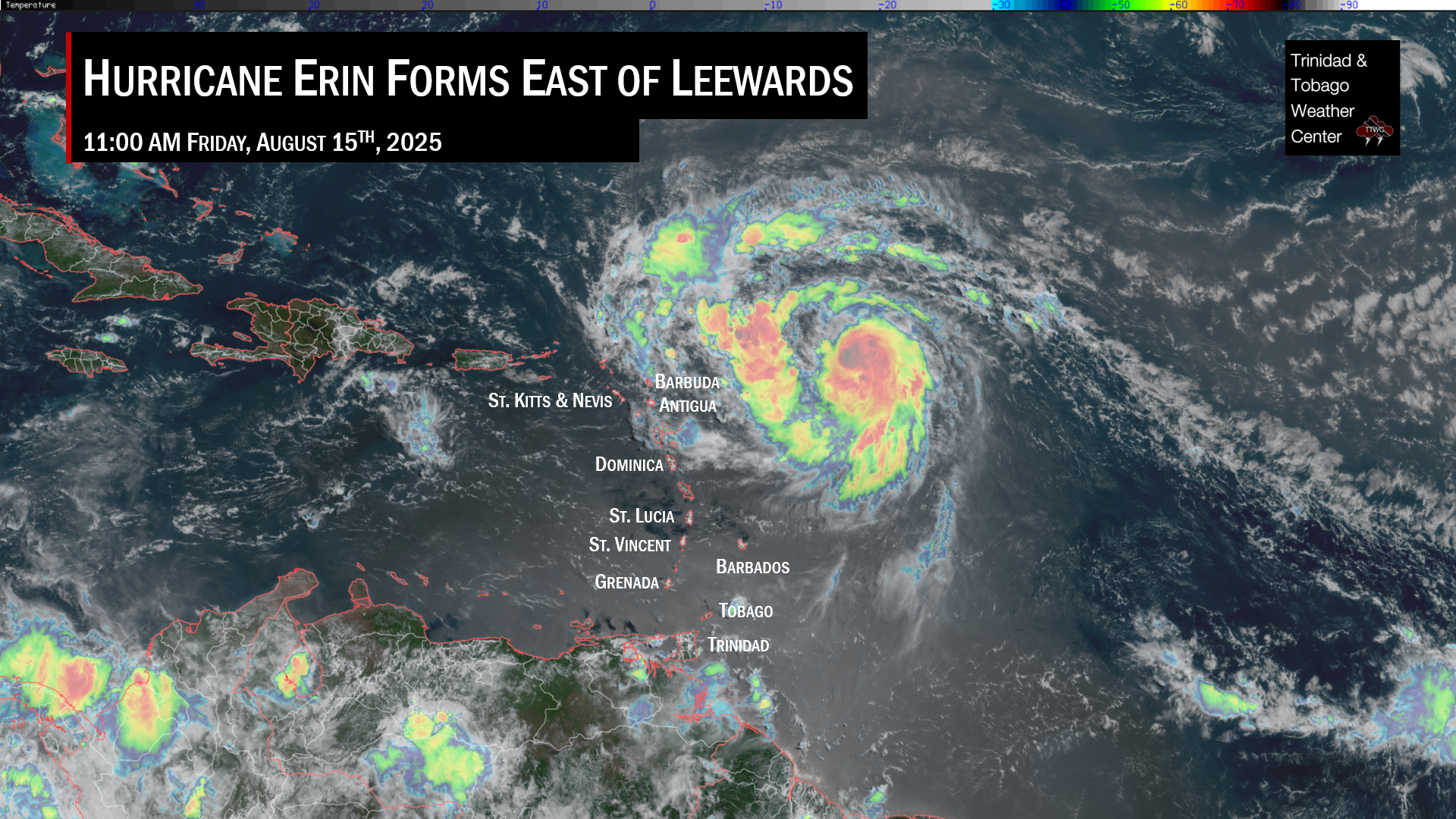
Tropical Storm Tammy has formed and is taking aim at the northern half of the Lesser Antilles, forecast to bring tropical-storm conditions, hazardous seas, and surge, as well as potentially flooding rainfall mere weeks after Tropical Storm Philippe caused destructive floods across Antigua and Barbuda and Guadeloupe.
For the southern Windward Islands, though, we remain on the lookout for feeder band activity, near calm winds, warm temperatures with slow-moving late morning through afternoon showers/thunderstorms are likely to occur through Saturday, with agitated seas.
What you need to know
— What has happened: A robust tropical wave, designated as Invest 94L, has formed into Tropical Storm Tammy east of the Lesser Antilles, with multiple islands north of Barbados and Dominica under tropical cyclone watches and warnings.
— Where is it forecast to move: Forecast models have consistently shown Tropical Storm Tammy remaining north of Trinidad and Tobago and the southern Windwards. The latest models and the National Hurricane Center forecast show the center of the system moving near or even across the northern Windwards and Leewards from Friday morning into Saturday.
— The Intensity & Impacts: The National Hurricane Center brings Tropical Storm Tammy’s circulation near or directly over the Leewards by Friday night through Saturday night, potentially strengthening into a hurricane. Damaging winds, flooding rainfall, and hazardous seas are forecast for the Leewards and northern Windwards from Friday morning for central and northern areas of the Lesser Antilles. For the southern Windwards, including T&T, while feeder band activity could bring periods of inclement weather, generally settled and near-calm conditions are likely with isolated daytime thunderstorms from the late morning through the afternoon.
— Latest from officials: There are multiple alerts, watches, and warnings in effect for the Lesser Antilles. See below for more information. For Trinidad and Tobago, there are no alerts, watches, or warnings in effect from the Trinidad and Tobago Meteorological Service.
The latest
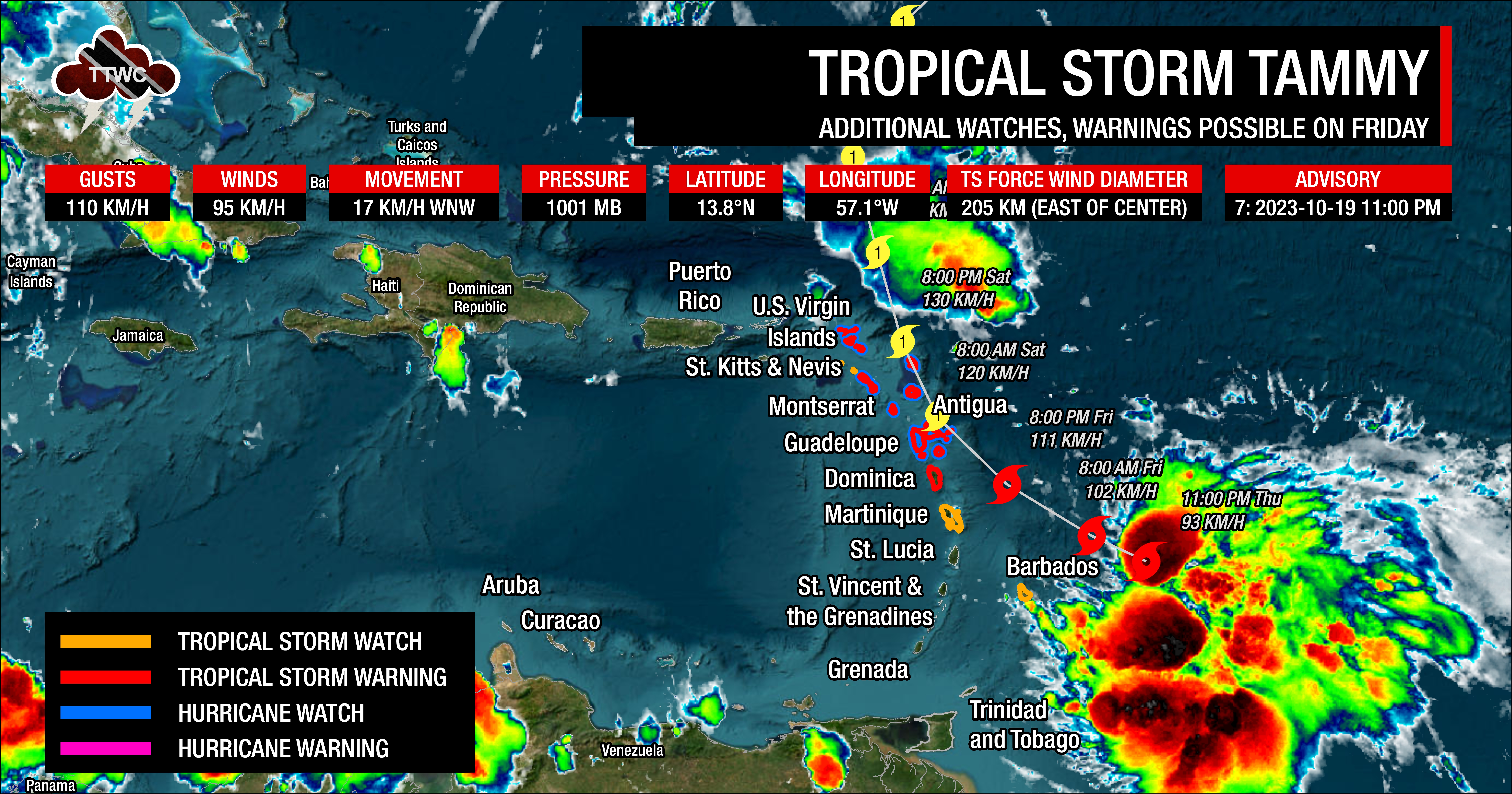
At 11:00 PM Thursday, October 19th, 2023, the center of Tropical Storm Tammy was located near latitude 13.8 North, longitude 57.1 West. Tammy is moving toward the west-northwest near 17 KM/H.
According to the National Hurricane Center (NHC), a gradual turn to the northwest with some additional slowdown is forecast on Friday, and this motion should continue through Saturday. A more northward motion is forecast to begin Saturday night or Sunday. On the forecast track, the center of Tammy will move near or over the Leeward Islands Friday and Saturday and then move north of the Leeward Islands Saturday night and Sunday.
Data from both Air Force Reserve and NOAA reconnaissance aircraft indicate that the maximum sustained winds remain near 95 KM/H with higher gusts to 110 KM/H. The NHC says gradual strengthening is expected to begin on Friday and continue into this weekend. Tammy is forecast to be at or near hurricane intensity when it moves near the Leeward Islands Friday night and Saturday.
Tropical-storm-force winds extend outward up to 205 kilometers, primarily to the east of the center. The latest minimum central pressure estimated from reconnaissance aircraft data is 1001 millibars.
Alerts, Watches, & Warnings
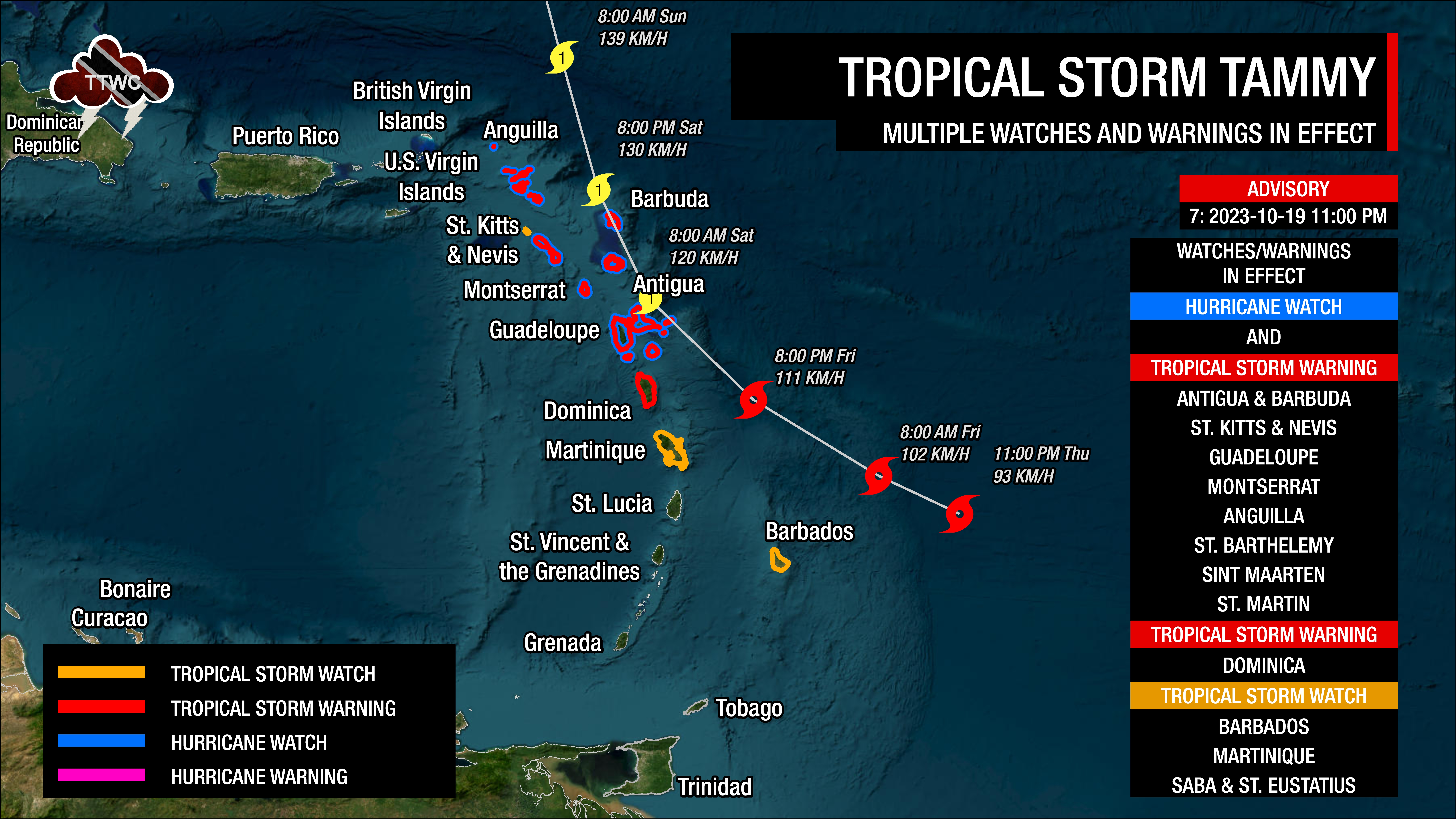
There are multiple alerts, watches, and warnings in effect for the Lesser Antilles as of 11:00 PM Thursday, October 19th, 2023. From south to north:
- Trinidad and Tobago: None
- Grenada: Small Craft Advisory
- St. Vincent and the Grenadines: Marine Advisory
- St. Lucia: Small Craft Advisory
- Barbados: Tropical Storm Watch, Small Craft Warning, High Surf Advisory
- Martinique: Tropical Storm Watch, Yellow Alert: Tropical Cyclones, Hazardous Seas
- Dominica: Tropical Storm Warning, Small Craft Warning, High Surf Advisory
- Guadeloupe: Hurricane Watch, Tropical Storm Warning, Orange Alert: Tropical Cyclones
- Montserrat: Hurricane Watch, Tropical Storm Warning
- Antigua and Barbuda: Hurricane Watch, Tropical Storm Warning, High Surf Warning, Small Craft Warning
- St. Kitts and Nevis: Hurricane Watch, Tropical Storm Warning, High Surf Warning, Small Craft Warning
- St. Barthelemy & St. Martin: Hurricane Watch, Tropical Storm Warning, Yellow Alert: Tropical Cyclones
- Saba & St. Eustatius: Tropical Storm Watch, Severe Wind Gusts, Flooding, Small Craft Advisory
- Sint Maarten: Hurricane Watch, Tropical Storm Warning, Small Craft Advisory
- Anguilla: Hurricane Watch, Tropical Storm Warning, High Surf Warning, Small Craft Warning
- British Virgin Islands: High Surf Warning, Small Craft Warning
A Hurricane Watch means that hurricane conditions are possible within the watch area. A watch is typically issued 48 hours before the anticipated first occurrence of tropical-storm-force winds, conditions that make outside preparations difficult or dangerous. A Tropical Storm Warning means that tropical storm conditions are expected somewhere within the warning area within 36 hours. A Tropical Storm Watch means that tropical storm conditions are possible within the watch area, generally within 48 hours.
Where is it going?
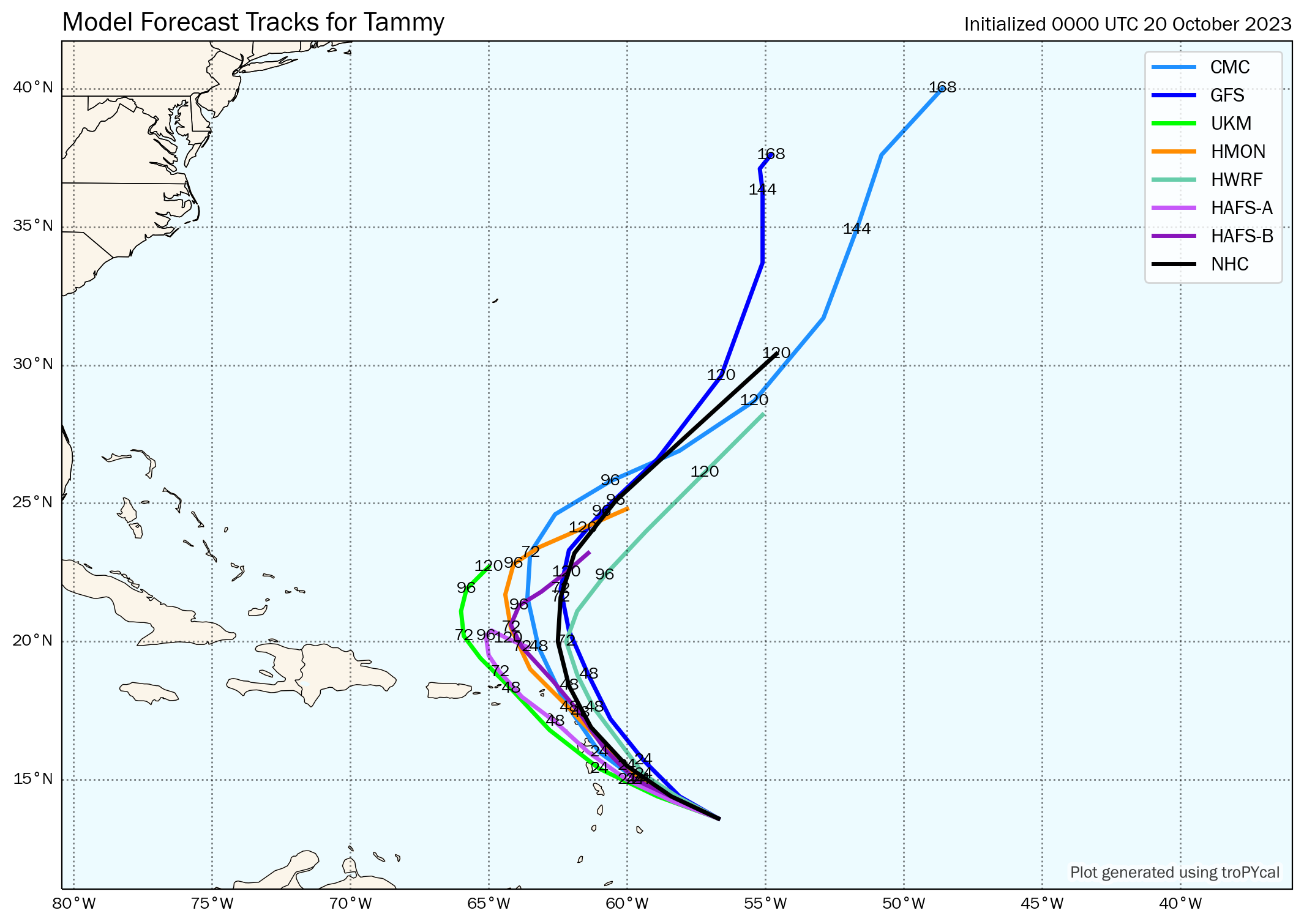
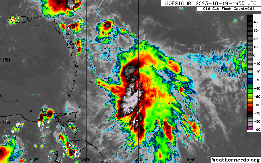
Tropical Storm Tammy has slowed down east of the Lesser Antilles over the last several hours and as continued to track south of model guidance. However, Tammy is forecast to continue moving along the western periphery of a high-pressure system anchored over the North Atlantic, taking it more northwestward on Friday through Saturday as a sharp, mid-latitude trough moves in from the west. Tammy’s motion could bring the center of circulation near or over the Leeward Islands by Friday night through Saturday with a fairly slow movement.
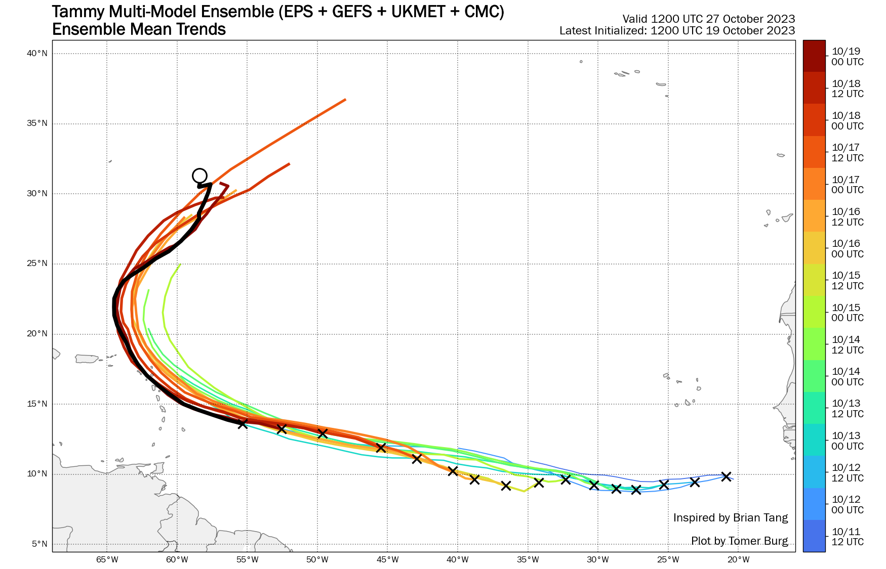
As it stands on Thursday evening, Tropical Storm Tammy is no direct threat to Trinidad and Tobago. While forecast models keep this low-pressure system north of the southern Windwards, those north of Barbados and St. Vincent and the Grenadines, feeder band activity could impact the region, including T&T. However, feeder bands are notoriusly difficult to forecast (in location, intensity and duration.)
How strong could it get?
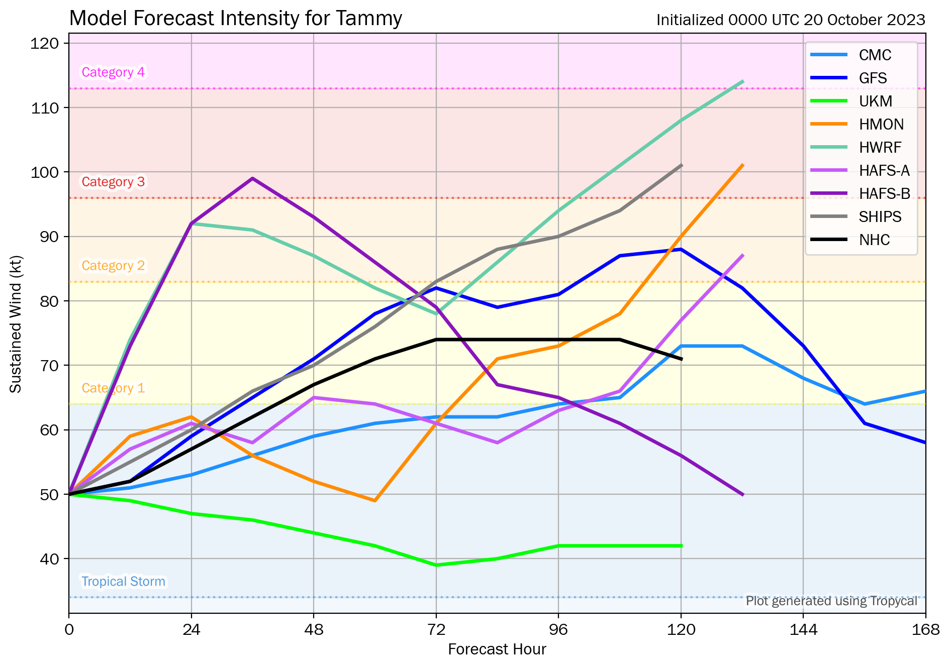
Tammy, though still packing quite a punch with winds of 95 KM/H and gusts to 110 KM/H, is still quite disorganized for a tropical storm. This disorganization should prevent any rapid intensification in the short term (through the next 48 hours) but it should be noted that both the HWRF and HAFS-B models, both top regional hurricane models, explictly show rapid intensification during tnis period, showcasing the uncertainty in the forecast. Most models, and the NHC show a gradually intensifying system. The NHC is forecasting Tammy to become a hurricane by Saturday afternoon (36-hour mark).
According to the NHC, warm sea surface temperatures and moderate wind shear could allow for intensification by the weekend (by the 48-hour mark). Once Tammy clears the Leeward Islands by the end of the weekend (96-hour mark), further strengthning is possible as it recurves over the central Atlantic Ocean.
What does this mean for the Lesser Antilles?
For the northern half of the Lesser Antilles, tropical cyclone preparedness plans should be rushed to completion, mainly north of Barbados and St Lucia, where Tropical Storm Warnings and Hurricane Watches are in effect. There is an increasing risk of heavy rainfall that will produce floods, landslides, and mudslides, as well as strong winds and gusts that can produce wind damage and agitated seas. See the local alerts above for more information.
For the southern half of the Lesser Antilles, mainly from Barbados and St. Vincent and the Grenadines southward, the main hazards from Friday into the weekend will be localized, heat-driven, heavy showers/thunderstorms along western and northern areas of islands, and potentially hazardous seas, mainly for the northern islands. Stronger southerly winds may also lead to isolated thunderstorms being enhanced by topography, and with near-calm to light winds mainly on Friday and clockwise turning winds through the atmosphere, the potential for funnel clouds will also exist.
Wind
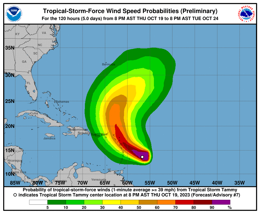
Based on the latest guidance and forecasts, tropical-storm-force winds and gusts (above 34 knots, 39 MPH, 63 KM/H) are forecast to primarily affect the northernmost Leewards, mainly north of Dominica and east of the U.S. Virgin Islands are forecast to experience wind gusts in heavy showers/thunderstorms, where Tropical Storm Warnings are in effect. Hurricane-foce wind gusts are possible, and stronger tropical-storm-force winds are likely, mainly for areas north of Guadeloupe towards Anguilla.
For the central Lesser Antilles (Martinique to St. Vincent and the Grenadines, including Barbados), a low-level to surface trough extending southwestward from the eventual low-pressure system will create slack to near-calm winds, leading to hot daytime temperatures and isolated late-morning through afternoon showers/thunderstorms along western and hilly areas. However, in feeder band activity, wind gusts to tropical-storm-force strength are possible.
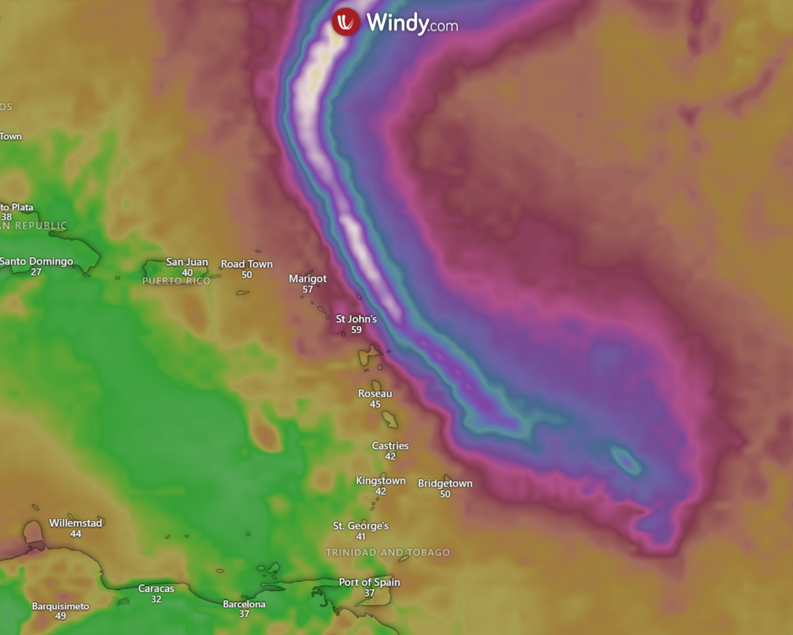
For the southern Lesser Antilles (south of the Grenadines, including T&T), the pressure gradient between the low-pressure system north of the Lesser Antilles and a high-pressure system over northern South America will lead to strong low-level southeasterly winds across the area from Friday (the peak) through Saturday, which can make it to the surface in showers or thunderstorms. Wind gusts exceeding 35 KM/H are likely during this period.
Rainfall
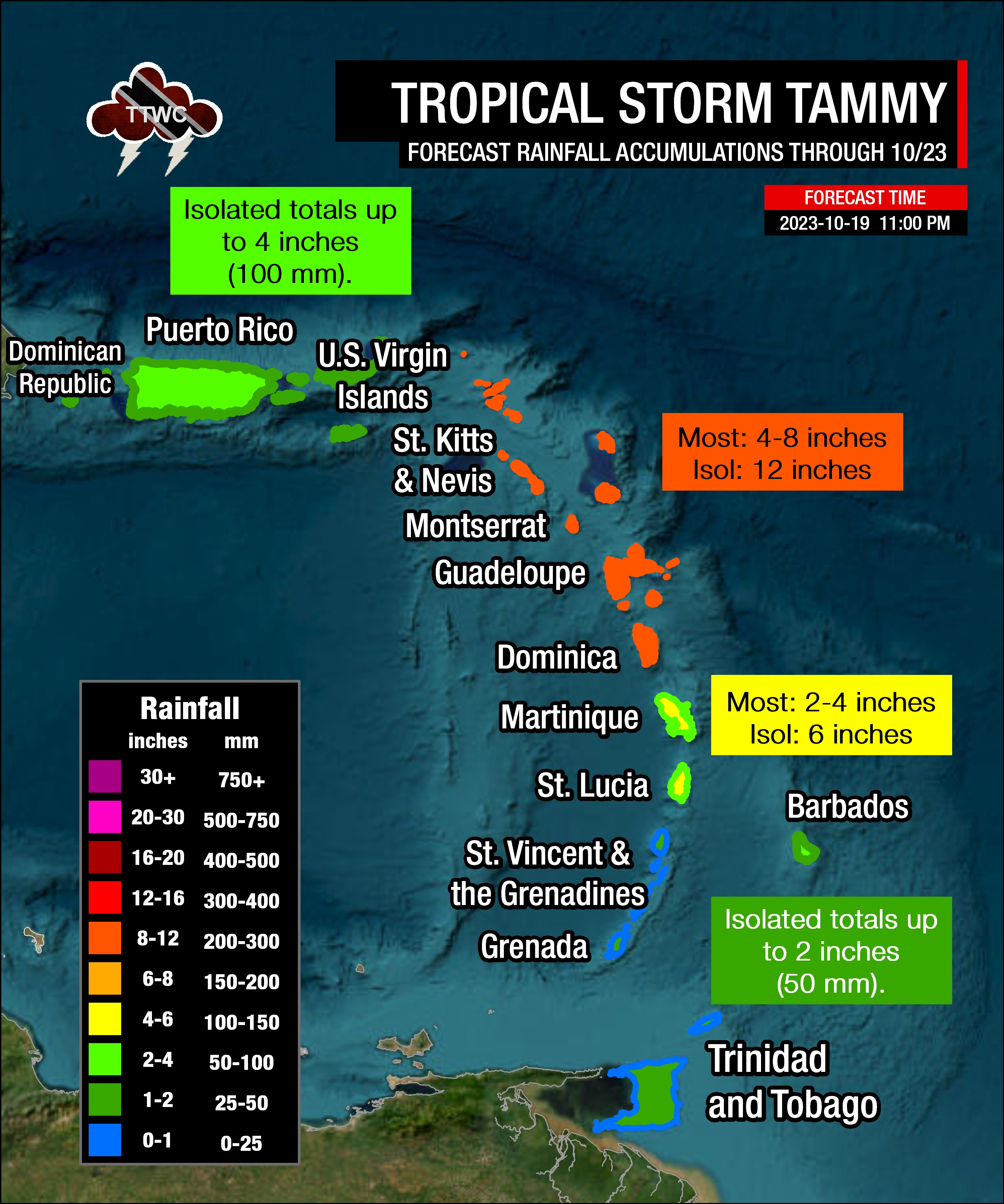
The highest rainfall accumulations are forecast to occur across the northernmost Leewards and the northern half of the Lesser Antilles, with rainfall totals through Monday, October 23rd, 2023, ranging between 100 and 200 millimeters (4-8 inches) with isolated totals up to 300 millimeters (12 inches) based on the current forecast track.
For the southern half of the Lesser Antilles, for Martinique and St. Lucia, rainfall totals are forecast to be between 50 to 100 millimeters (2-4 inches), with isolated totals of up to 150 millimeters (6 inches).
For Barbados, between 25 to 75 millimeters (1-3 inches) are forecast, with the remainder of the southern Windwards, including T&T, forecast to see up to 25 millimeters (1 inch) with isolated totals up to 50 millimeters (2 inches)
Seas and Storm Surge
Based on the latest model guidance:
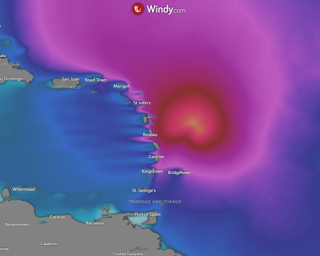
- For Trinidad and Tobago, and Grenada to St. Vincent and the Grenadines: Open water waves are forecast to reach as high as 2.5 meters, particularly Friday into Saturday
- For Barbados to Martinique: Open water waves are forecast to be near 3.5 meters, nearing 4.5 meters in channels between islands and Atlantic-facing coasts, with the highest waves forecast on Friday night through Sunday morning.
- For Dominica to Anguilla (not including St. Kitts & Nevis and the Leeward Dutch Antilles): 3.5 meters to 5 meters, reaching as high as 7 meters in channels and Atlantic-facing coasts of Antigua and Barbuda.
For islands north of Martinique, storm surge could raise sea levels by 1-3 feet (up to 1 meter) above sea level near coastal areas.
For Trinidad and Tobago
Latest Forecast

Wet Easter Weekend Forecast For T&T
Trinidad and Tobago is NOT under any tropical storm or hurricane threat, watch, or warning at this time.
Pay close attention to official forecasts in the coming hours and days from your respective authorities. For Trinidad and Tobago, official forecasts and early warnings come from the Trinidad and Tobago Meteorological Service.