Slight to Moderate Seas Forecast For T&T

Winds are set to remain generally light to moderate across Trinidad and Tobago over the next seven days, leading to slight to moderate seas. Windier conditions are forecast by Monday, leading to more moderate seas in open waters. No spring tides, long-period swells, or hazardous seas are anticipated over the next seven days, but this is dependent on ongoing tropical cyclone activity in the North Atlantic.

Latest Alerts

Trinidad and Tobago is NOT under any tropical storm or hurricane threat, watch, or warning at this time.

Seas Forecast For Trinidad and Tobago

Sea state through the next seven days as generally slight to moderate seas are forecast. Note that sheltered areas include bays, beaches, and generally, the Gulf of Paria and western areas of the Columbus Channel in Trinidad and the western coasts of Tobago. Open waters are the Atlantic Ocean (Eastern Trinidad and Tobago), the Eastern Columbus Channel (Southern Trinidad), and the Caribbean Sea (north of Trinidad, west of Tobago).

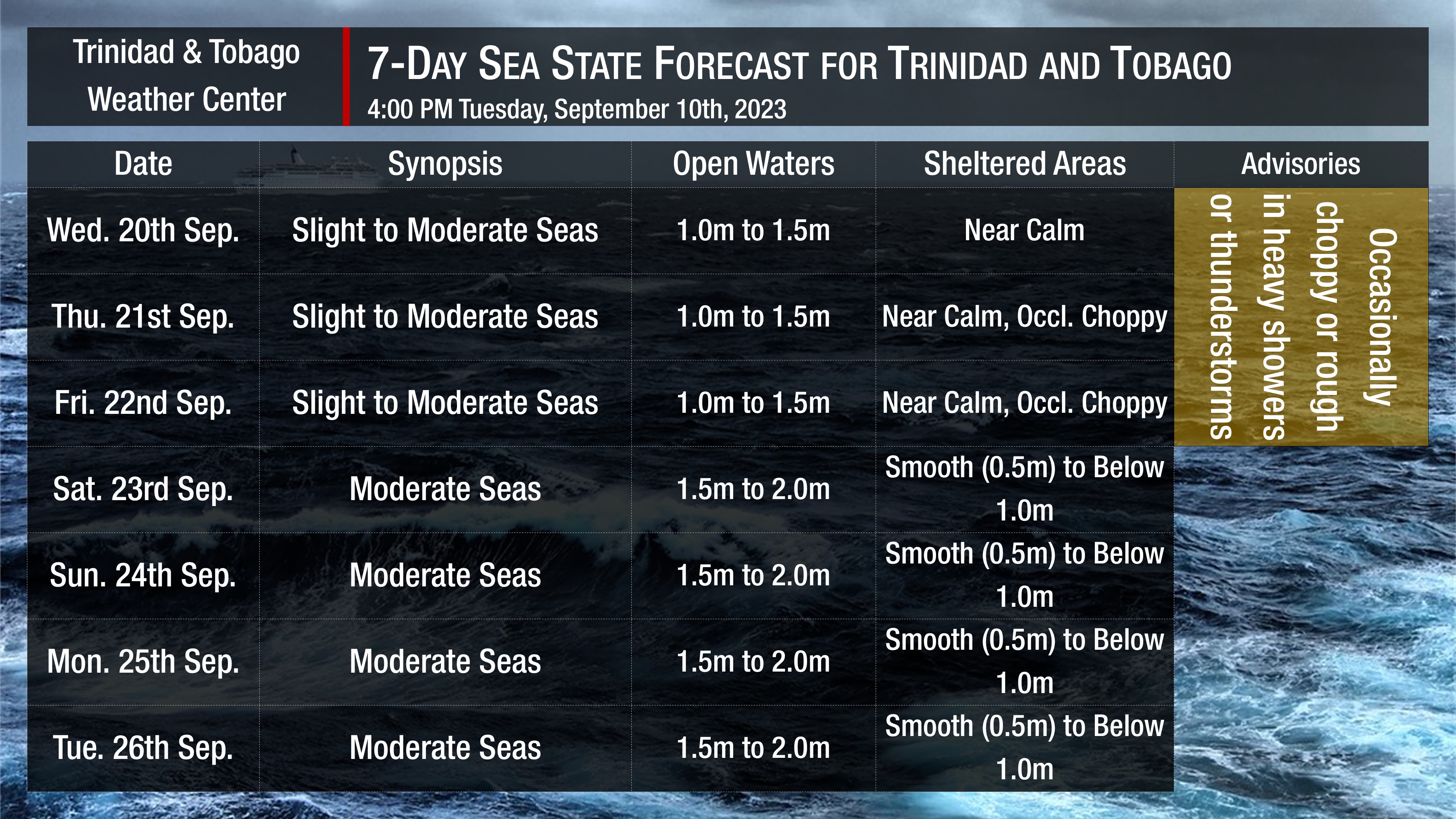
Wednesday through Friday: Seas are forecast to be slight to moderate in open waters with waves between 1.0 meter and 1.5 meters, while in sheltered areas, waves are forecast to be calm to near calm but occasionally choppy due to heavy showers or thunderstorms. Swell periods are forecast to range between nine and 11 seconds. Winds are forecast to range between 5 to 10 knots from the southeast to east-northeast, gusting to 20 knots in the vicinity of heavy showers or thunderstorms.

Saturday through Tuesday: Seas are forecast to be moderate in open waters with waves between 1.5 and 2.0 meters, while in sheltered areas, waves are forecast to be between 0.5 and 1 meter. Swell periods are forecast to range between 6 and 10 seconds. Winds are forecast to range between 10 to 15 knots from the southeast to northeast, gusting between 20 and 25 knots, particularly near showers or thunderstorms.

Tidal forecast for Port of Spain, Trinidad (above) and Scarborough, Tobago (below) courtesy Tide-Forecast.com

Possible Impacts

Saharan Dust concentrations are forecast to fluctuate at mild to moderate concentrations through the forecast period.

While there are no outright marine hazards, many of our northern and eastern beaches are prone to rip current activity, which can be deadly.

How to spot a rip current

Rip Currents

Going to the beach is one of Trinidad and Tobago’s favorite pastimes, but not too far from the shore lies a seemingly hidden danger – rip currents. As waves crash on our…
Total
0
Shares
Related Posts
Total
0
Share
perihoki perihoki perihoki perihoki perihoki duta76 duta76 duta76 duta76 duta76 gates of olmpus perihoki main sekali bisa langsung wede perihoki beri perkalian besar di starlight princess x1000 panduan trik jam gacor pgsoft mahjong ways di perihoki pola jackpot mahjong ways 2 pgsoft perihoki buat heboh perihoki beri cara dapat scatter hitam mahjong wins 3 scatter petir emas gates of olympus duta76 auto tajir duta76 bongkar rahasia gitar dan emas wild bandito rtp pgsoft mahjong ways 2 naik pola duta76 lagi bocor pola jitu duta76 mahjong ways pgsoft jadi perbincangan main di duta76 pemuda ini dapat jackpot mahjong wins 3 Aksi kilat farhan mahjong ways Kisah spektakuler joko mahjong wins Kode rahasia warna scatter mahjong wins Kombinasi warna scatter mahjong wins Mahjong wins 3 pola lintas generasi Pertarungan epik scatter hitam mahjong wins Pgsoft luncurkan pola eksklusif mahjong ways Pgsoft mahjong ways 2 update pola scatter shock Strategi kilat pro player scatter hitam mahjong Trik terpendam mahjong ways 2 pola gacor