


Gusty winds swept across Trinidad, Tobago, and offshore areas on Wednesday and Thursday, associated with a low-level jet and low-level wind surge. While the peak of this event has passed, the Met Office has downgraded the High Wind Alert to Yellow Level, as gusts may still accompany isolated showers or thunderstorms on Friday.
What you need to know
— Rainfall: Through the next 12 hours, mostly hazy and variably cloudy skies with isolated light to moderate showers are possible, favoring western, southern, and hilly areas of Trinidad. Through Saturday morning, between 0 and 5 millimeters of rain is forecast across the country, with isolated totals exceeding 5 millimeters across southern and eastern coastal areas.
— Hazards: Gusty winds in excess of 45 KM/H are likely, with gusts in excess of 55 KM/H remain possible, accompanying isolated heavy showers or thunderstorms.
Latest Alerts

Localized Flood Alert Discontinued For Trinidad
Trinidad and Tobago is NOT under any tropical storm or hurricane threat, watch, or warning at this time.
The High Wind Alert
The Trinidad and Tobago Meteorological Service downgraded the High-Wind Alert (Orange Level) on Friday morning at 9:51 AM. The alert went into effect from 8:00 AM Wednesday, June 14th, 2023, and remains in effect through 2:00 PM Friday, June 16th, 2023. The alert is in effect for Trinidad, Tobago, and offshore areas.
Trinidad and Tobago is not under any tropical storm watch or warning at this time.
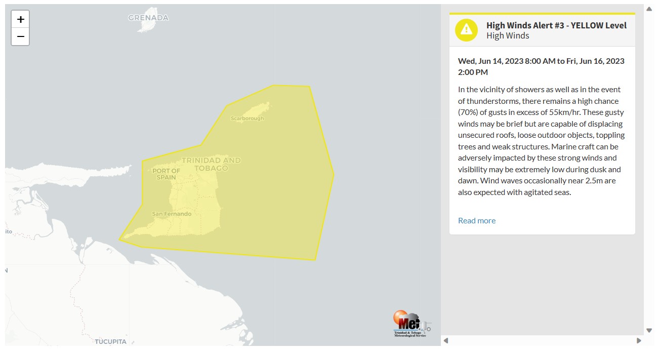

“In the vicinity of showers, as well as in the event of thunderstorms, there remains a high change (70%) of gusts in excess of 55km/h. These gusty winds may be brief but are capable of displacing unsecured roofs, loose outdoor objects, toppling trees, and weak structures. Marine craft can be adversely impacted by these strong winds, and visibility may be extremely low during dusk and dawn. Wind waves occasionally near 2.5m are also expected with agitated seas,” according to the Trinidad and Tobago Meteorological Service. This “alert” status takes into account the possibility of the event occurring. This high wind event is likely.

The color of the alert indicates the severity of the event and the probability of the event occurring. Currently, the alert level is Yellow. This means that the hazard is likely, but the severity of impacts is moderate for this particular alert. You should be aware of the hazards in your area associated mainly with gusty winds in excess of 55 KM/H.
These include the toppling of potted plants and light objects outdoors falling over or becoming airborne. Larger but weaker trees may fall, causing roof damage or downing power lines and utility poles. Unsecured roofs may be damaged. These strong winds are forecast to agitate seas and reduce visibility in marine areas.
For a moderate High Wind Alert, there is the potential for possible injuries, where behavioral changes are required to ensure safety. There may be minor damage to property, with income-earning temporarily disrupted, and a couple of communities are affected.
The Met Office is advising the public to secure loose items outdoors and livestock. Small craft operators should be on the alert for above-normal or choppy sea conditions in strong winds. Avoid venturing into floodwaters. The public should monitor weather conditions and updates from official sources.


