


A low-level jet is forecast to develop across the Southern Windwards, producing strong winds at low levels of the atmosphere. In heavy showers and thunderstorms, these strong winds can make it to the surface, producing damaging gusty winds. On Tuesday, showers and thunderstorms have already produced wind gusts to 50 KM/H across parts of Tobago.
Over the next 36 hours, a weak tropical wave, the Intertropical Convergence Zone, and this low-level jet are all forecast to interact across T&T, producing isolated to scattered showers and isolated thunderstorms, favoring southern and eastern Trinidad and Tobago.
What you need to know
— Rainfall: Through the next 48 hours, isolated areas of rain, moderate to heavy showers, and isolated thunderstorms are forecast, interrupting variably cloudy and increasingly hazy skies. Peak intense activity is forecast on Wednesday through Thursday afternoon. Over the next 24-48 hours, an additional 5-15 millimeters of rain is forecast across Trinidad, with isolated higher amounts ranging between 25-40 millimeters favoring southern and eastern areas of Trinidad.
— Hazards: Gusty winds in excess of 45 KM/H (expected) to in excess of 55 KM/H (likely) are forecast. Stronger gusts are forecast to accompany heavy showers or thunderstorms. Lightning will accompany thunderstorms.
Latest Alerts

Localized Flood Alert Discontinued For Trinidad

Localized Flood Alert Issued For Trinidad
Trinidad and Tobago is NOT under any tropical storm or hurricane threat, watch, or warning at this time.
The High Wind Alert
The Trinidad and Tobago Meteorological Service issued a High-Wind Alert (Yellow Level) on Tuesday afternoon at 3:59 PM. The alert goes into effect from 8:00 AM Wednesday, June 14th, 2023, and remains in effect through 2:00 PM Friday, June 16th, 2023. The alert is in effect for Trinidad, Tobago, and offshore areas.
Trinidad and Tobago is not under any tropical storm watch or warning at this time.
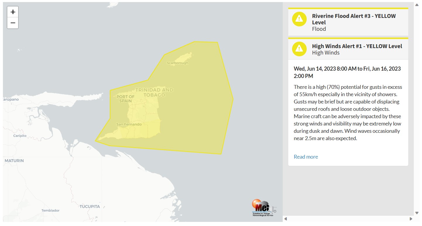
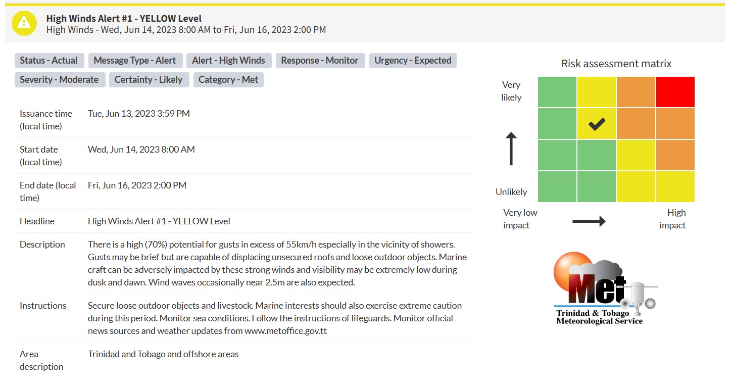
“There is a high (70%) potential for gusts in excess of 55km/h especially in the vicinity of showers. Gusts may be brief but are capable of displacing unsecured roofs and loose outdoor objects. Marine craft can be adversely impacted by these strong winds and visibility may be extremely low during dusk and dawn. Wind waves occasionally near 2.5m are also expected.” according to the Trinidad and Tobago Meteorological Service. This “alert” status takes into account the possibility of the event occurring. This high wind event is likely.

The color of the alert indicates the severity of the event and the probability of the event occurring. Currently, the alert level is Yellow. This means that the hazard has been observed, but the severity of impacts is moderate for this particular alert. You should be aware of the hazards in your area associated mainly with gusty winds in excess of 55 KM/H.
These include the toppling of potted plants and light objects outdoors falling over or becoming airborne. Larger but weaker trees may fall, causing roof damage or downing power lines and utility poles. Unsecured roofs may be damaged. These strong winds are forecast to agitate seas and reduce visibility in marine areas.
For a moderate High Wind Alert, there is the potential for possible injuries, where behavioral changes are required to ensure safety. There may be minor damage to property, with income-earning temporarily disrupted, and a couple of communities are affected.
The Met Office is advising the public to secure loose items outdoors and livestock. Small craft operators should be on the alert for above-normal or choppy sea conditions in strong winds. Avoid venturing into floodwaters. The public should monitor weather conditions and updates from official sources.


