


Heavy rains fell across the southern half of Trinidad on Sunday, producing significant rainfall accumulations that caused multiple rivers across central and southern areas to overtop. Several communities remain underwater on Sunday night as flood waters rise, with additional rainfall on its way.
What you need to know
— What has happened: Over the last 24 hours, between 50 and 80 millimeters of rain fell across parts of southern and central Trinidad, with totals up to 25 millimeters across northern Trinidad. Compounding the flooding situation, over the next 24 hours, an additional 15-35 millimeters of rain is forecast across Trinidad, with isolated higher amounts favoring southern and eastern areas of Trinidad.
— What to expect: More rainfall over the next 24 hours. Riverine flooding is likely across river basins across southern Trinidad, particularly smaller tributaries to larger rivers.
Latest Alerts

Flooding Continues To Subside As Riverine Flood Alert Discontinued
Trinidad and Tobago is NOT under any tropical storm or hurricane threat, watch, or warning at this time.
The Riverine Flood Alert
The Trinidad and Tobago Meteorological Service issued a Riverine Flood Alert (Yellow Level) at 10:12 PM Sunday. The alert went into effect for parts of southern Trinidad from 10:10 PM Sunday, June 11th, 2023 and remains in effect until 5:00 PM Monday, June 12th, 2023. The alert is in effect for the Cipero River and the South Oropouche River, as well as all surrounding tributaries. Note that tributaries and smaller rivers outside of this alert area have overtopped or near threshold levels in central Trinidad
Trinidad and Tobago is not under any tropical storm watch or warning at this time.
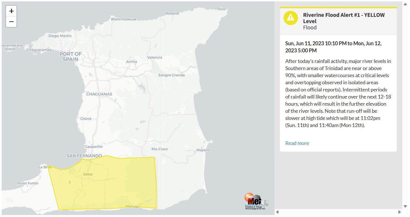
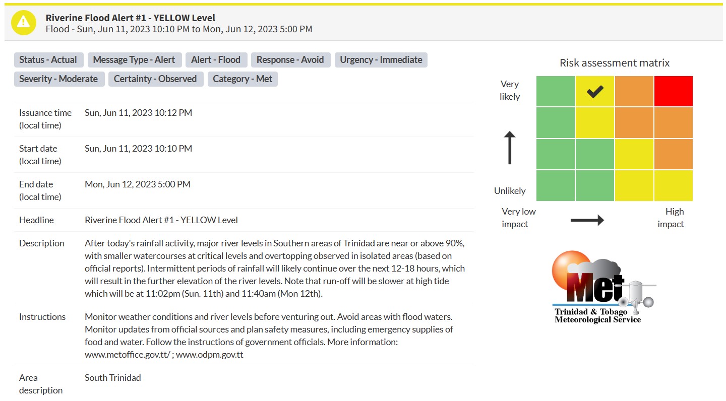
“After today’s rainfall activity, major river levels in Southern areas of Trinidad are near or above 90%, with smaller watercourses at critical levels and overtopping observed in isolated areas (based on official reports). Intermittent periods of rainfall will likely continue over the next 12-18 hours, which will result in the further elevation of the river levels. Note that run-off will be slower at high tide which will be at 11:02pm (Sun. 11th) and 11:40am (Mon 12th).” according to the Trinidad and Tobago Meteorological Service. This “alert” status takes into account the possibility of the event occurring. This riverine flood event has been observed.

The color of the alert indicates the severity of the event and the probability of the event occurring. Currently, the alert level is Yellow. This means that the hazards have been observed, and the severity of the impacts is moderate for this particular alert. You should be aware of the hazards in your area, and you need to be aware of the impacts of street, flash, and riverine flooding in your area.
For a moderate Riverine Flood Alert, there is the potential for possible injuries, where behavioral changes are required to ensure safety. There may be minor damage to property, with income-earning temporarily disrupted and a couple of communities affected. Note that depending on the amount of rain that falls overnight Sunday into Monday, this alert could be raised to orange level.
The Met Office is advising the public to monitor weather conditions and river levels before venturing out, avoid areas with flood waters, monitor updates from official sources and plan safety measures, including emergency supplies of food and water, and follow the instructions of government officials.


