When tropical cyclones near Trinidad and Tobago, generally passing north of the country, the question always arises: “Why are we not under a watch or warning?”
The very short answer is that if a tropical storm or hurricane watch or warning is not issued, the chances of tropical storm-force or hurricane-force winds are low, generally below 30%.
However, a tropical storm or hurricane watch or warning is a very specific type of watch/warning and doesn’t account for other hazards associated with tropical cyclones, including torrential rainfall, hazardous seas, the potential for tornadoes, storm surge, and coastal flooding.
Tropical Storm & Hurricane Watches/Warnings are for very specific conditions.
These specific watches and warnings are issued solely based on sustained wind speeds produced by tropical depressions, storms, or hurricanes.
Why am I under a tropical storm watch or warning?
A tropical storm warning is an announcement that sustained winds of 34 to 63 knots (39 to 73 mph or 63 to 118 km/hr) are expected somewhere within the specified area within 36 hours in association with a tropical, subtropical, or post-tropical cyclone.
A tropical storm watch is an announcement that sustained winds of 34 to 63 knots (39 to 73 mph or 63 to 118 km/hr) are possible within the specified area within 48 hours in association with a tropical, subtropical, or post-tropical cyclone.
A hurricane watch or warning is issued when a tropical cyclone begins producing winds greater than 119 KM/H or has the potential to do so.
Why am I under a hurricane watch or warning?
A Hurricane Warning is an announcement that sustained winds greater than 74 MPH or 119 KM/H are expected somewhere within the specified area within 36 hours in association with a tropical, subtropical, or post-tropical cyclone.
A Hurricane Watch is an announcement that sustained winds of greater than 74 MPH or 119 KM/H are possible within the specified area within 48 hours in association with a tropical, subtropical, or post-tropical cyclone.
As mentioned earlier, when it comes to tropical cyclones, these specific watches or warnings are based solely on the potential for tropical storm-force or hurricane-force winds, not on other hazards associated with a tropical storm (hazardous seas, torrential rainfall, etc.).
If the system tracks close to your country, but the strongest winds remain offshore or north/east of your location, you may not be placed under a tropical storm watch or warning or hurricane watch or warning, but you may have other advisories in effect.
According to the Trinidad and Tobago Meteorological Service’s Meteorologist II (Ag.) Carolyn Decouteau, the Met Office uses the likelihood (probability) of tropical storm-force or hurricane-force winds to place T&T and Grenada and its dependencies under a tropical storm or hurricane watch or warning when the probability exceeds 30%.
The Luck of T&T: Remaining On The Southern Side
Trinidad and Tobago is on the southern periphery of what is known as the “Hurricane Alley” of the Atlantic, and as a result, most tropical cyclones stay north of the country. Since 1850, of the 84 tropical depressions, storms, or hurricanes that have moved within 100 nautical miles of Trinidad and Tobago, 17 have moved across or within one nautical mile of the country.
Generally, with low-pressure systems – from strong tropical waves, tropical depressions, tropical storms, and hurricanes, the northern portion of the low-pressure area has the highest impact with the strongest winds, heaviest rainfall, and roughest seas. Conversely, the southern half of these systems has light to near-calm winds (depending on the system’s strength and proximity to the center if it’s a strong tropical storm/hurricane), leading to cloudy, humid, and warm conditions.
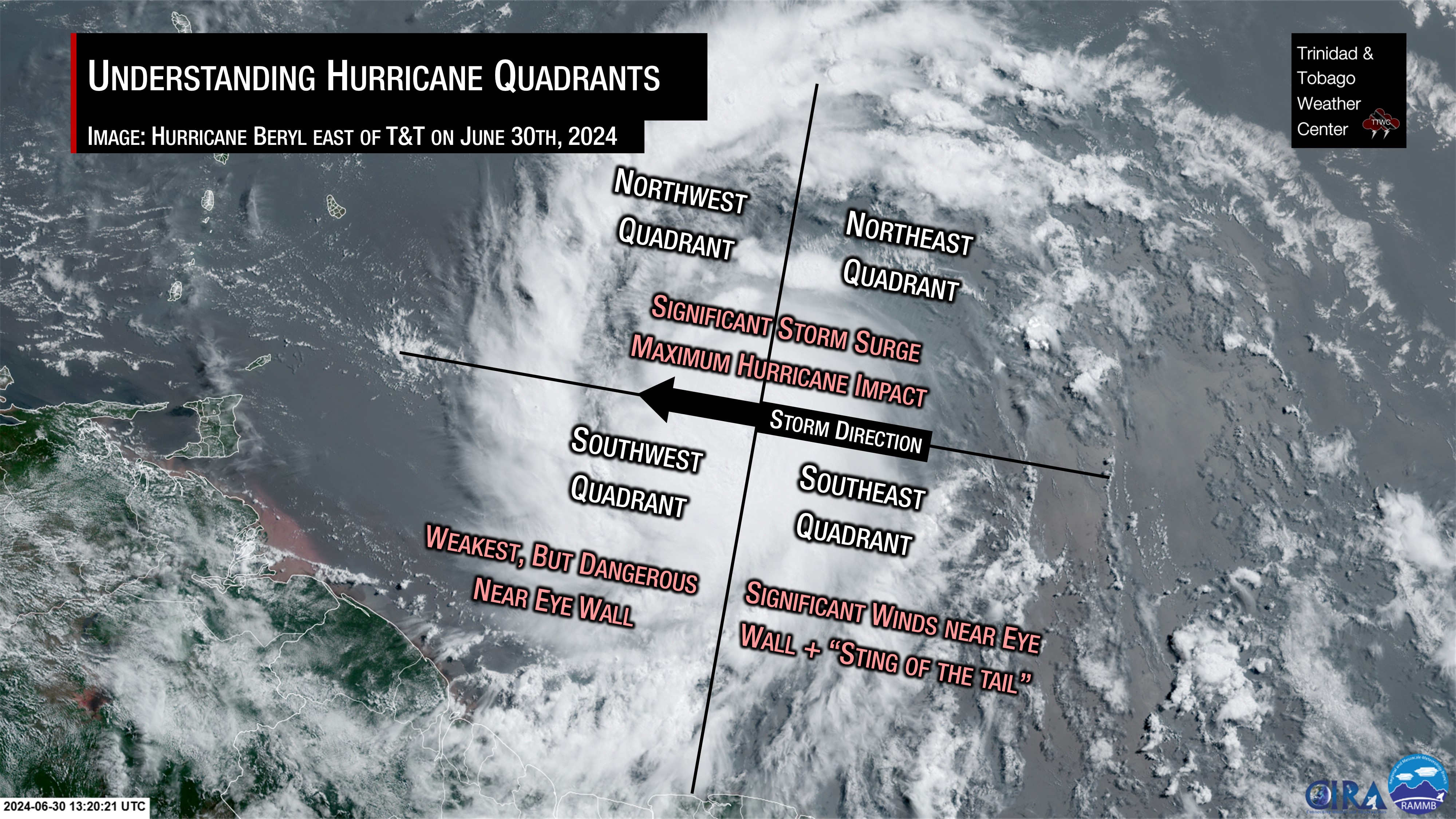
Tropical storms and hurricanes can be divided into four regions based on the direction of storm tracks.
Northern Half (Northwest or Right-Front & Northeast or Right-Back Quadrants)
Across the northern half of the storm, we see the strongest winds, as the storm’s general east-to-west movement compounds the already powerful winds near the system’s core, which, in this half, generally moves from east to west as well.
When a hurricane makes landfall in the Caribbean, areas hit by the northern half of the storm typically sustain the worst of the damage.
It is where we see extreme winds, flooding, heavy rain, and dangerous storm surge. This is also likely where outer bands spawn tornadoes. Most tornadoes formed from a tropical system are usually short-lived and appear 100 miles or 160 kilometers to the east of the eye wall.
Research has shown that, in hurricanes and tropical storms, most tornadoes occur between 200 km and 750 km from the storm center. In stronger cyclones, such as hurricanes, most tornadoes occur in the right-front quadrant of the storm. They relocate to the lower right-front quadrant and right-back quadrant as the cyclones become weaker (e.g., tropical depressions).
The most dangerous wind speeds are located in the northeastern (right-back) quadrant of a tropical storm or hurricane. Apart from the eye wall, the strongest winds within the storm are located here. The winds blow from southeast to east, which can exacerbate storm surge and flooding, especially in areas that have been hard hit by the northwestern (right-front) quadrant, where winds blow from the east to the southwest.
Southwest (Left-Front) Quadrant
Dangerous winds exist near the storm’s core in this quadrant, which can cause rough seas and storm surge.
However, once away from the hurricane or tropical storm’s core or eye wall, if one exists, this is considered the “weakest” part of the storm. When powerful low-pressure systems move through the Lesser Antilles, this area, where winds shift from the northwest to the southeast, is at odds with the trade-wind flow and the storm’s general westward motion.
When tropical cyclones (tropical storms and hurricanes) have a small core, the strongest winds remain closest to the center of circulation. In the case of small but strong tropical storms or hurricanes, these strong winds are generally near the eye wall of the system. The further away from the core, particularly on the southern half of the system, the winds decrease dramatically.
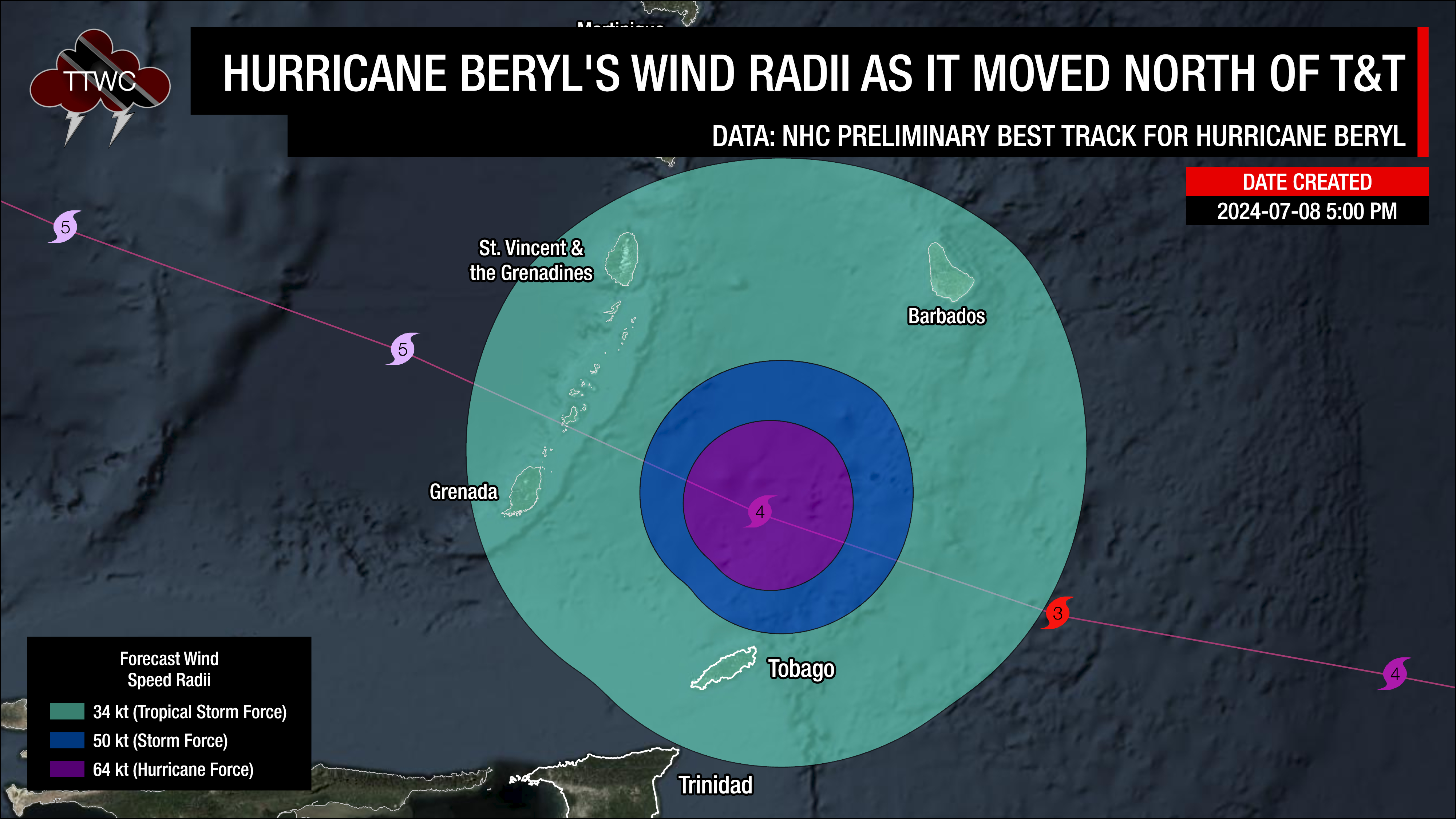
In the case of Hurricane Beryl, which moved north of T&T on July 1st, 2024, Tobago’s northeasternmost point was 75 kilometers away from Beryl’s eye with tropical-storm-force winds across the island and, to a lesser extent, northeastern Trinidad. However, when you look at how Beryl’s winds were distributed, tropical storm-force winds extended 130 kilometers on the southwestern side but up to 195 kilometers on the northern side of the hurricane.
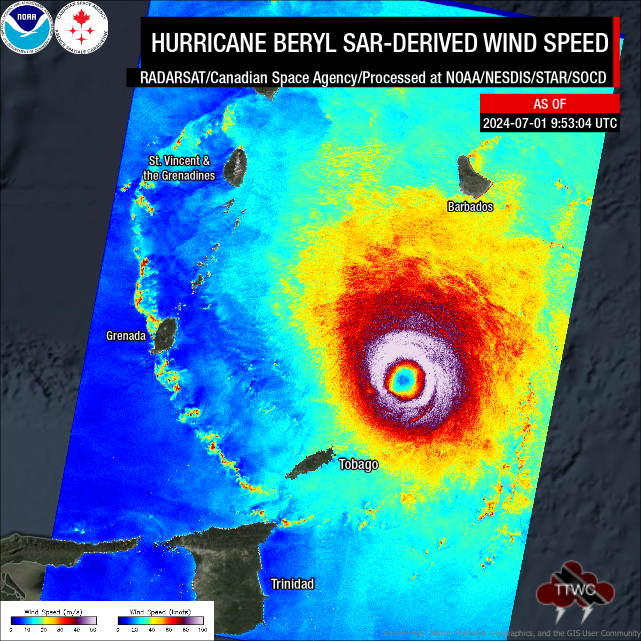
However, while windy conditions (less than tropical-storm-force) were observed north of Beryl, across Trinidad, winds were calm to light, which is quite typical. While this generally means settled weather initially, if conditions become destabilized by sufficient daytime heating, isolated strong thunderstorms can develop.
As powerful low-pressure systems, like Hurricane Beryl, move north, light southerly winds (from the southwest to southeast) and near-calm conditions create optimal conditions for funnel cloud development as sea-breeze convergence and daytime heating dominate.
Additionally, with steering from south to north for any shower or thunderstorm, Trinidad’s mountain ranges enhance shower and thunderstorm activity, leading to intense rainfall along south-facing slopes.
If the northerly wind flow continues into the evening and night, strong thunderstorms along the northern coast of Venezuela can move toward Trinidad, producing intense lightning and heavy rainfall, particularly in the Gulf of Paria and across southern Trinidad.
Southeast (Left-Back) Quadrant
In this area, winds generally move from the southeast to the northwest. Damaging winds, dangerous seas, and storm surge are expected near the core of the storm.
However, meteorologists in the Caribbean often talk about the “sting of the tail,” where feeder bands trailing a tropical storm or hurricane, with enhanced convergence, lead to severe weather. Training showers and thunderstorms are often found here, where they move over the same area for hours, posing a significant flash-flood risk.
Feeder bands trailing tropical storms or hurricanes can continue up to a day after the system clears the area, depending on the forward speed of the tropical cyclone. Flooding poses a threat not only in feeder bands but also in frequent lightning, funnel clouds, waterspouts, and tornadoes.
As mentioned above, research has shown that most tornadoes occur between 200 km and 750 km from the storm center, and that with weaker tropical cyclones, such as borderline tropical storms and tropical depressions, tornadoes mostly form in the lower-right-front and right-back quadrants.
Generally, after a tropical cyclone moves across the area, a high-pressure ridge builds, leading to a period of settled weather just after the cyclone’s influence on the atmosphere ceases. However, this is not a hard-and-fast rule, as another tropical wave or cyclone could follow the initial tropical system.
What about other alerts for T&T?
Ultimately, this is left to the Trinidad and Tobago Meteorological Service, which looks at the likelihood of impactful rainfall and thunderstorms for an Adverse Weather Alert, impactful seas for a Hazardous Seas Alert, or impactful winds/gusts for a High Wind Alert. The Trinidad and Tobago Meteorological Service is the only organization authorized to issue an official alert, watch, or warning for T&T and, in the case of tropical cyclones, for Grenada and its dependencies.
While alerts, watches, or warnings may not be issued for a tropical storm or hurricane if you are outside its path, hazards always extend well beyond the system’s center.
Generally, our advice is to ensure you are ready to face a tropical storm or hurricane by having yourself, your family, and your property prepared to deal with flooding, rainfall, and strong winds between June and November every year. It is also important to ensure you have supplies to last at least 72 hours in the event of power outages or other hazards materializing.