Heavy rainfall and gusty winds have moved across the Windward Islands, including Trinidad and Tobago, associated with Tropical Wave 35, now tagged as Tropical Disturbance Invest 90L.
As Invest 90L moves into the Caribbean Sea over the next 24 hours, a deep-layered and moist southeasterly flow is forecast to bring copious amounts of moisture and instability across the Windwards on Sunday, leading to further heavy rainfall and occasional gusty winds.
The National Hurricane Center has now given Invest 90L a high chance of tropical cyclone formation over the next seven days.
What you need to know
— What has happened: An area of low pressure formed along the axis of Tropical Wave 35 and is moving into the Caribbean Sea on Saturday night. High levels of moisture and instability, combined with favorable upper-level conditions, have produced heavy rainfall up to 2 inches (50 mm) across the Windwards, with totals up to 4 inches across Trinidad. Gusty winds up between 50 KM/H and 90 KM/H have been recorded across the Windwards and French Antilles.
— Where is it forecast to move: This disturbance is forecast to move into the Caribbean Sea on Sunday, with two different tracks depending on the eventual strength. A stronger system moves over the Greater Antilles and northward into the Atlantic Ocean, while a weaker system says in the south-central Caribbean Sea.
— The Intensity & Impacts: Overall, this tropical disturbance is forecast to produce rainfall amounts between 50 and 100 millimeters from Trinidad and Tobago to Barbuda between Saturday and Monday, with higher amounts up to 150 millimeters. Stronger wind gusts are forecast to remain north of Barbados and St. Vincent, where gusts could exceed 65 KM/H and reach as high as 90 KM/H.
— Latest from officials: Across the island chain, there are no tropical storm watches or warnings. However, several meteorological offices have issued local alerts, watches, and warnings for flooding, thunderstorms and agitated seas.
The latest
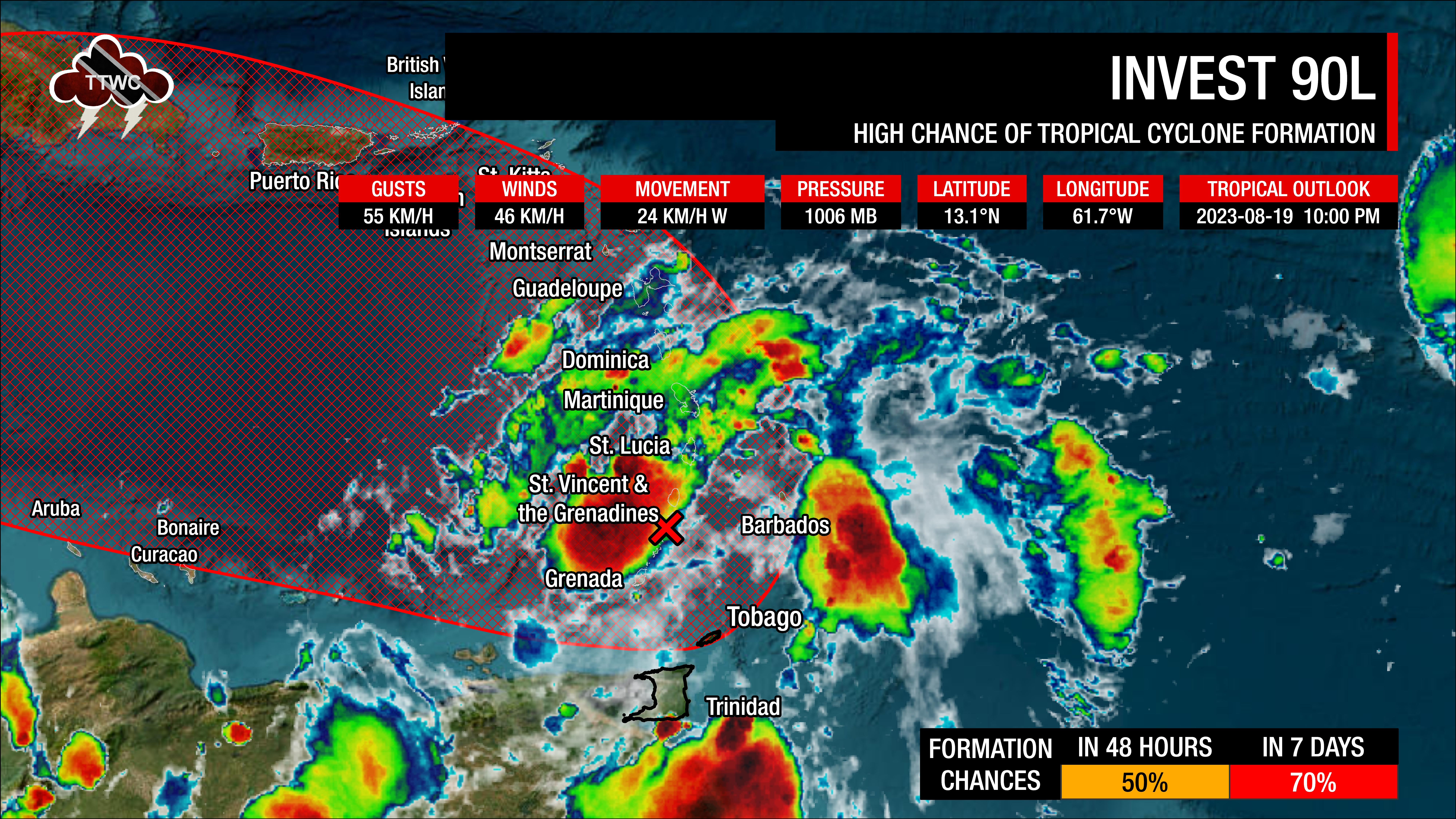
At 10:00 PM Saturday, August 19th, 2023, the axis of Tropical Wave 35/center of low pressure associated with Invest 90L was located along 61.7°W, well north of Trinidad and Tobago
According to the National Hurricane Center’s 8:00 PM Tropical Weather Outlook, “Shower and thunderstorm activity continues in association with an area of low pressure near the Windward Islands. Some additional development of this system is likely, and a tropical depression could form by early next week while this system moves westward to west-northwestward at 10 to 15 MPH (16-26 KM/H) over the eastern and central Caribbean Sea.”
This area of low pressure is producing scattered showers and thunderstorms across and near Trinidad, Tobago, and the Windward Islands with widespread cloudiness. It is also located in a pocket of favorable upper-level divergence, low-level convergence, and a narrow area of light to moderate wind shear. Sea surface temperatures are between 29°C and 30°C with anomalously high atmospheric moisture. The area of low pressure is also pulling isolated strong thunderstorms off the north coast of Venezuela northward toward T&T.
When it comes to development chances, the NHC gives Invest 90L a medium (50%) chance of tropical cyclone formation over the next 48 hours and a high (70%) chance of development over the next five days.
Current Alerts, Watches, Warnings
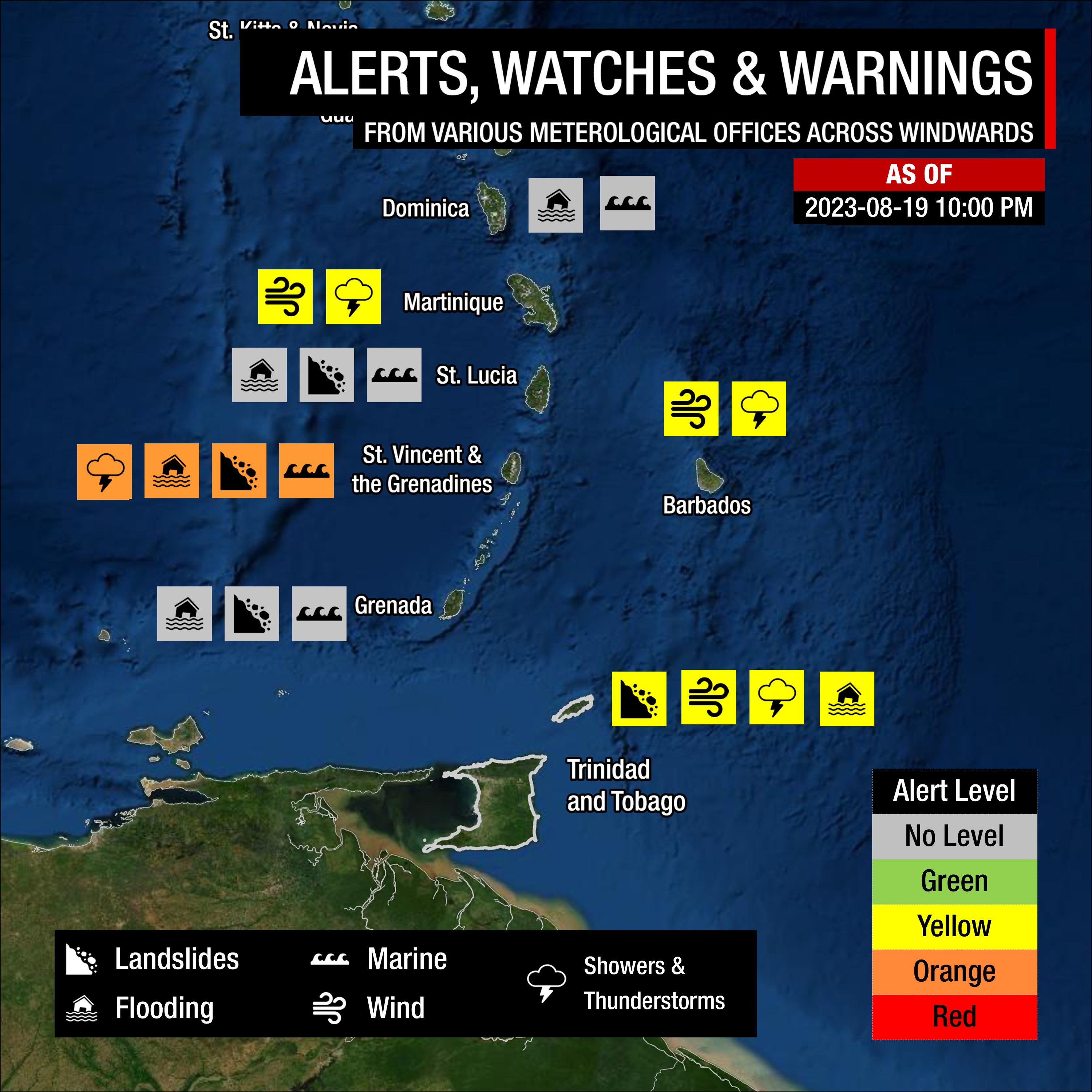
For Trinidad and Tobago, Trinidad and Tobago Meteorological Service issued an Adverse Weather Alert (Yellow Level) from 6:00 PM Saturday through 6:00 PM Sunday.
Barbados has yellow-level alerts for excessive rainfall through August 20th and for small craft through August 20th.
Grenada’s Meteorological Service has the country and its dependencies under an alert for flash flooding and landslides and a marine advisory in effect for small crafts.
St. Vincent and the Grenadines Met Service has the country under orange-level weather warnings for heavy showers and thunderstorms and a marine warning for large waves, with a flash flood watch until 6:00 AM Monday, August 21st, 2023.
The St. Lucia Met Service has advised of flash flooding, landslides, and locally rough seas, leading to a small craft advisory on Friday evening.
A small craft advisory is also in effect for Dominica, with their Met Service issuing a flood warning until Sunday, August 20th, 2023.
Both Martinique and Guadeloupe are under yellow-level alerts for heavy rainfall and strong winds through August 21st.
There are no tropical storm watches or warnings in effect for the Lesser Antilles, including T&T.
What could be the impacts on the Lesser Antilles?
Favorable upper-level conditions are forecast to enhance showers and thunderstorms across the island chain, leading to flooding rainfall, agitated seas, and gusty winds. Fallen trees, landslides/mudslides, and power outages with coastal, street, and flash flooding are possible.
Wind
On Saturday, several countries reported wind gusts of tropical depression or tropical-storm strength. Grantley Adams International Airport, Barbados, reported wind gusts up to 65 KM/H and sustained winds up to 46 KM/H between 7:00 AM and 11:00 AM Saturday. Argyle International Airport, St. Vincent, reported sustained winds up to 41 KM/H and wind gusts up to 54 KM/H on Saturday morning. Further north in Martinique, a wind gust of 78 KM/H was reported on Mount Pelée and 87 KM/H at Vauclin. In Guadeloupe, gusts of 71 KM/H in Abymes Raizet, 70 KM/H in La Désirade, 66 KM/H in Grand-Bourg and Morne-à-l’Eau were reported.
As with all strong tropical waves, the strongest winds remain across the northern portion of the wave axis. In this case, the northern half of the axis extends north of St. Vincent and Barbados to the Leewards. Across these islands, winds are likely to reach up to 50 KM/H and gusts as high as 90 KM/H, particularly in heavy showers, thunderstorms, and hilly terrain on windward or Atlantic-facing slopes.
For Grenada and T&T, sustained winds can reach as high as 40 KM/H and gust to 55 KM/H, particularly in heavy showers and thunderstorms. Locally higher gusts are possible in strong thunderstorms as a result of upper-level support, particularly on Sunday.
When strong low-pressure systems (strong tropical waves, tropical storms, or even hurricanes) move sufficiently north of T&T, the winds across Trinidad and Tobago become light to near-calm as the pressure gradient across the area slackens. This occurred on Saturday, with stronger southerly to southeastern winds on Sunday through early Tuesday, leading to faster-moving showers and thunderstorms, moving from the south/southeast to north/northwest.
Rainfall
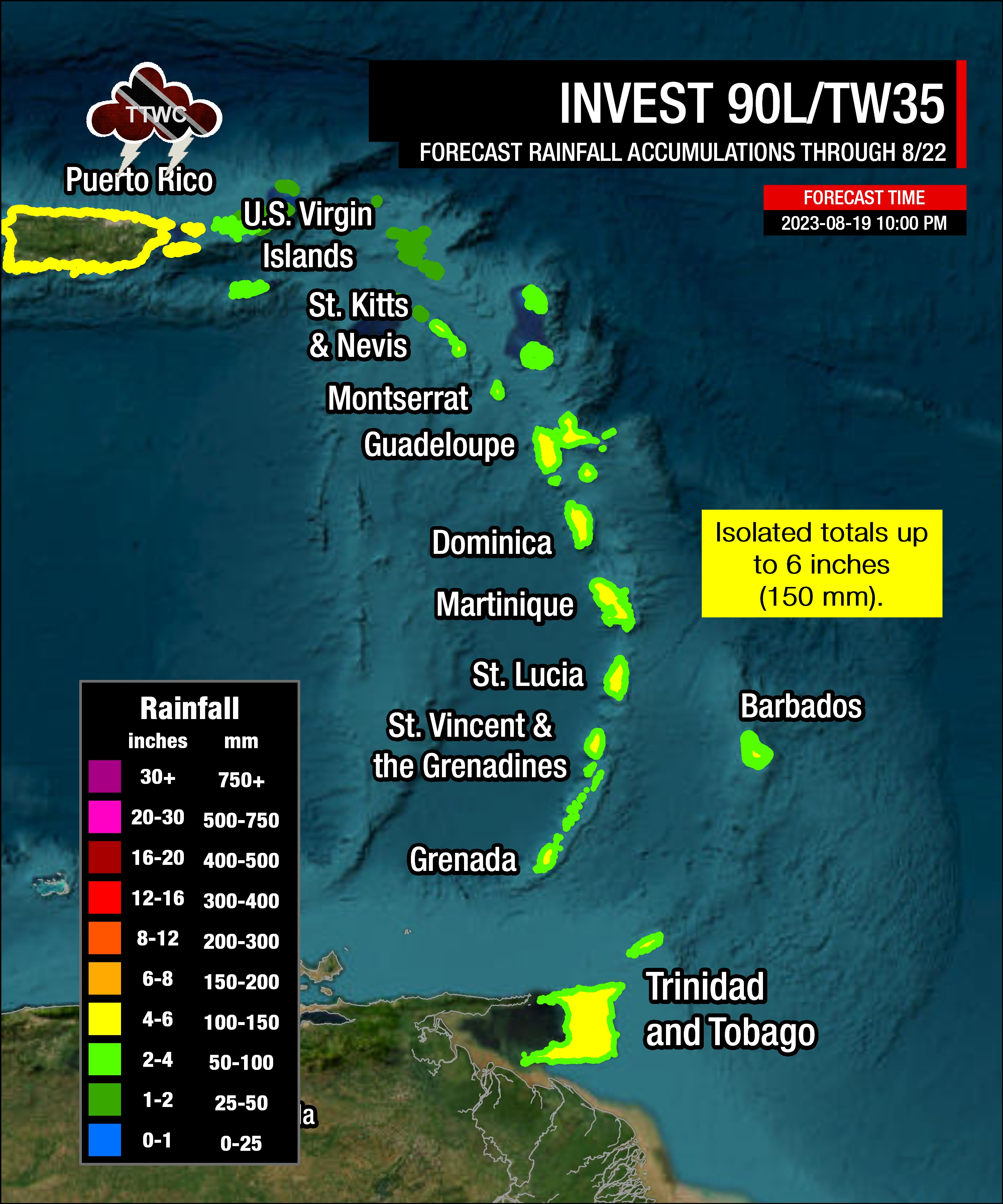
The highest rainfall accumulations are forecast to occur across St. Lucia to Guadeloupe, with rainfall totals through Tuesday, August 22nd, 2023 ranging between 50 and 100 millimeters (2-4 inches) with isolated totals up to 150 millimeters (6 inches).
For Barbados, St. Vincent and the Grenadines, Grenada, and T&T, rainfall totals are forecast between 50 and 100 millimeters (2-4 inches) and isolated totals up to 150 millimeters (6 inches), favoring windward/Atlantic-facing coastlines and south-facing slopes.
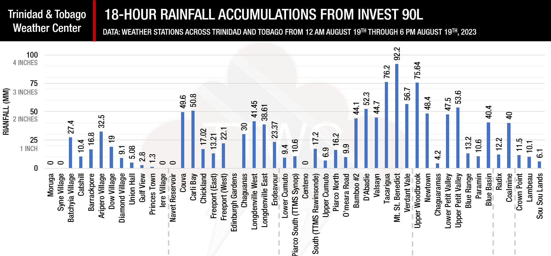
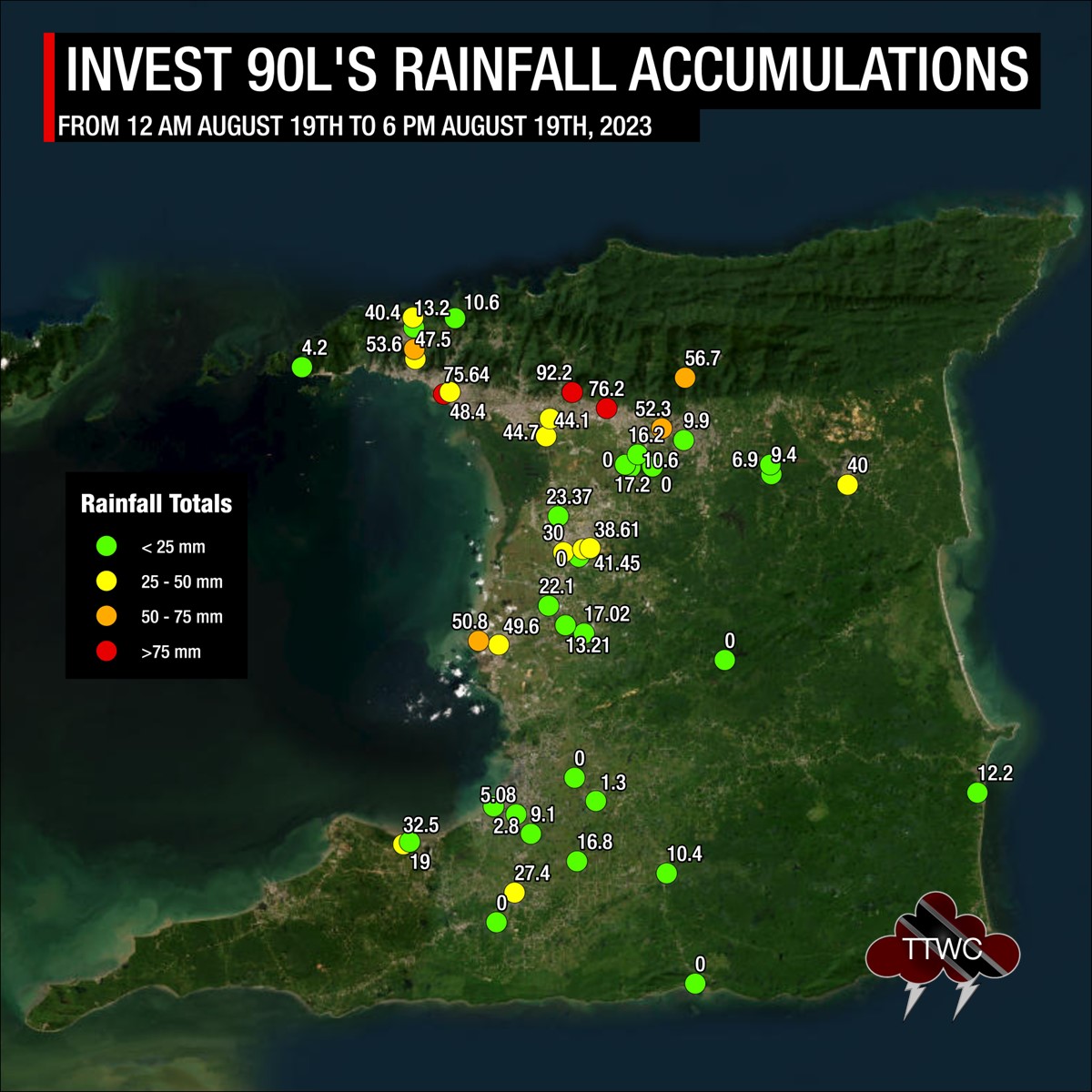
Across Trinidad and Tobago, most areas received between 1 to 2 inches (25 to 50 millimeters) of rainfall, with isolated totals of up to 4 inches (100 millimeters).
Seas and Storm Surge
Forecast models are showing waves in open waters are forecast to exceed 2.5 meters (8 feet) and up to 4.0 meters (12 feet) near east-facing coastlines north of Barbados to Guadeloupe. For areas between islands, waves can reach as high as 4.0 meters (13 feet) near coastlines and higher in open waters. These higher seas are forecast to remain well north of Trinidad and Tobago, with hazardous seas likely from St. Vincent and the Grenadines, as well as Barbados northward. For T&T, seas are forecast to remain moderate with open waters waves occasionally up to 2.5 meters this weekend into early next week.
For Trinidad and Tobago
Tropical Wave 35/Invest 90L’s worst impacts are still forecast to remain north of Trinidad and Tobago.
As forecast, by late Saturday through Sunday, as this disturbance moves into the Caribbean Sea, southerly to southeasterly wind flow feeds into the tropical wave with showers and thunderstorms trailing, moving across Trinidad, Tobago, and the Windwards again.
On Sunday, a deep-layered southeasterly to southerly flow of winds, moisture, and instability are forecast to maintain cloudiness, showers, and thunderstorms across T&T and the Windward Islands, generally settling by the evening.
Like Saturday evening, with southerly winds prevailing through Sunday, thunderstorm activity from northern Venezuela may drift toward Trinidad, particularly within the Gulf of Paria and near south Trinidad, leading to agitated seas and heavy rainfall.
Conditions are forecast to settle by Monday morning as a ridge regains dominance.
Pay close attention to official forecasts in the coming hours and days from your respective authorities. For Trinidad and Tobago, official forecasts and early warnings come from the Trinidad and Tobago Meteorological Service.