


There are no major changes in the latest advisory from the National Hurricane Center, with Bret still briskly moving towards the central Lesser Antilles and the Windward Islands.
While Tropical Storm Bret poses no direct threat to Trinidad and Tobago at this time, periods of showers and thunderstorms associated with outer bands and influenced convergence from Bret are forecast from Wednesday evening through Friday night across and near the country.
What you need to know
— What has changed: There have been no major changes. Tropical storm watches have been issued for countries in the central Lesser Antilles, and Bret has maintained strength over the last 6-8 hours.
— Where is it forecast to move: Forecast models have honed in on the center of circulation moving across the central Lesser Antilles near St. Lucia and Martinique, well north of Trinidad and Tobago.
— The Intensity & Impacts: The current forecast track places islands northward of St. Vincent and Barbados and southward of Dominica at the highest risk for damaging winds, flooding rainfall, storm surge, and hazardous seas. The National Hurricane Center’s forecast calls for a tropical storm with sustained winds up to 100 KM/H and gusts to 120 KM/H moving across the central Lesser Antilles. For the southern Windwards, southward of St. Vincent and the Grenadines, as well as Barbados to Trinidad and Tobago, feeder bands could extend southward, bringing showers/thunderstorms and gusty winds. In addition, light to near-calm winds will lead to increased daytime temperatures, localized, slow-moving afternoon showers and thunderstorms, and agitated seas mainly on Thursday, with increased winds from the southeast on Friday.
— Latest from officials: Tropical Storm Watches are in effect for Barbados, Dominica, St. Lucia, and Martinique, with additional watches or upgrades to warnings likely later today.
The latest
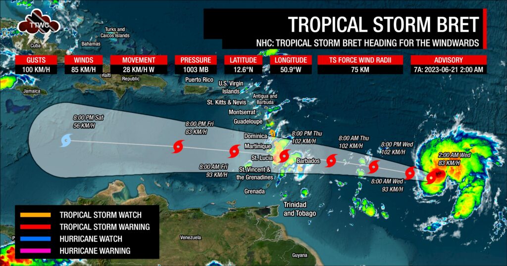
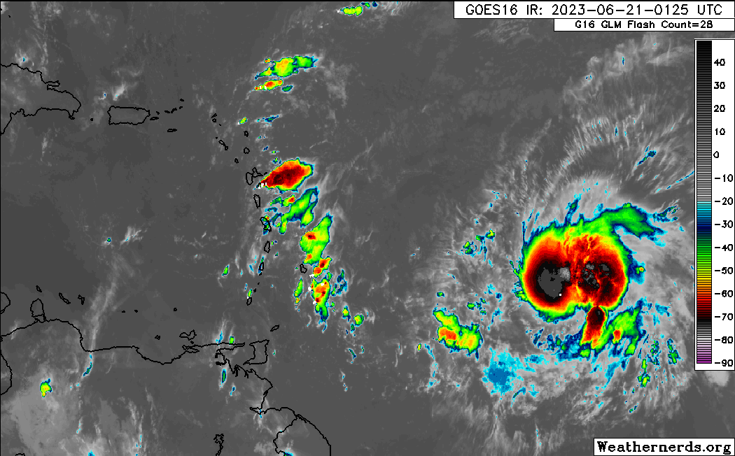
At 2:00 AM Wednesday, June 21st, 2023, Tropical Storm Bret’s approximate center of circulation was located at 12.6°N and 50.9°W, placing the center approximately 1,275 kilometers east-northeast of Tobago and 950 kilometers east of Barbados.
According to the National Hurricane Center’s 2:00 AM Advisory, Tropical Storm Bret is moving west at a brisk pace of 28 KM/H, and this is forecast to continue for the next several days, approaching the Lesser Antilles by Thursday afternoon into the night.
Maximum sustained winds have increased to 85 KM/H with gusts to 100 KM/H, with some strengthening forecast over the next day or so. The NHC says this system is forecast to remain a tropical storm as it moves across the Lesser Antilles, with weakening forecast thereafter in the Caribbean Sea. The current minimum central pressure is 1003 millibars, with tropical storm-force winds extending outwards up to 75 kilometers from the center.
Current Watches & Warnings

Tropical storm watches are now in effect for the following countries:
- Barbados
- Dominica
- St. Lucia
- Martinique
A Tropical Storm Watch means that tropical storm conditions are possible within the watch area, generally within 48 hours.
Interests elsewhere in the Lesser Antilles should monitor the progress of Bret. Additional tropical storm watches or warnings will likely be required for other islands later today.
There are no alerts, watches, or warnings in effect for Trinidad and Tobago at this time from the Trinidad and Tobago Meteorological Service.
What could be the impacts?

For Barbados and the central Lesser Antilles, tropical-storm conditions are possible on Thursday with sustained winds up to 100 KM/H, which can produce wind damage across the islands. Seas are forecast to become hazardous, with forecast rainfall totals likely to produce street/flash flooding and landslides.
For St. Vincent, southward to Tobago (and to a lesser extent Trinidad), and north of Guadeloupe, feeder bands could produce periods of heavy rainfall and gusty winds which would be capable of producing localized wind damage, street/flash flooding, and locally rough/choppy seas.
For the remainder of the Leewards and westernmost Greater Antilles, little to no major impacts are forecast.
Wind
As mentioned above, the National Hurricane Center is forecasting, as of 2:00 AM Wednesday, June 21st, 2023, a tropical storm with sustained winds up to 100 KM/H and gusts to 120 KM/H moving across the French Antilles, mainly between St. Vincent and Dominica.
Certainty has increased in both track and intensity, with nearly all intensity models, in line with the National Hurricane Center’s forecast, showing a tropical storm at the time of Bret’s passage across the Lesser Antilles.
Over the last 24 hours, the track has shifted south and stabilized near St. Lucia and Martinique as a result of Bret remaining weaker than initially forecast.

With weaker tropical cyclones, the stronger winds generally remain on the northern half of the system’s circulation, meaning St. Lucia, Martinique, Dominica, and even Guadeloupe, could see winds of tropical storm strength.
With feeder bands forecast to traverse much of the eastern Caribbean over the next 48-72 hours, the National Hurricane Center has much of the eastern Caribbean area, north of Trinidad and Tobago, under a low to medium probability of experiencing tropical storm-force winds, but higher probabilities now exist for the central countries of the island chain.
While the southern Windwards aren’t in the direct line of fire from Tropical Storm Bret at this time, outer bands from the tropical cyclone could still have strong showers and thunderstorms that produce tropical-storm-force wind gusts or sustained winds for brief moments – hence the risk is not zero.
Global models, which keep Bret weaker, show higher winds remaining north of the southern Windward Islands, including Trinidad and Tobago. As mentioned earlier, when strong low-pressure systems (strong tropical waves, tropical storms, or even hurricanes) move sufficiently north of T&T, the winds across Trinidad and Tobago become light to near-calm as the pressure gradient across the area slackens. By Friday, across Trinidad and Tobago, winds are forecast to increase from the southeast, with faster-moving showers and thunderstorms forecast.
Rainfall

Generally, rainfall totals associated with Bret are forecast to range between 50 and 150 millimeters (2-6 inches), with higher totals up to 250 millimeters (10 inches) along Windward facing coastlines near the center of circulation in the central Lesser Antilles – namely, from Barbados and St. Vincent and the Grenadines, northward to Guadeloupe. Isolated higher amounts are possible, but the fast-moving nature of Bret is forecast to limit persisting heavy rainfall and higher accumulations.
As mentioned above, feeder bands, convergence associated with Bret, and local topography could produce locally heavy rainfall totals that may trigger localized flooding and mudslides/landslides. Ultimately, all islands across the Lesser Antilles should remain on guard for some form of flooding rainfall associated with this tropical cyclone later this week, whether there is a direct impact or not.
Seas and Storm Surge
Similar to the rainfall totals, how agitated seas become and the level of storm surge is dependent on the strength of the tropical cyclone.
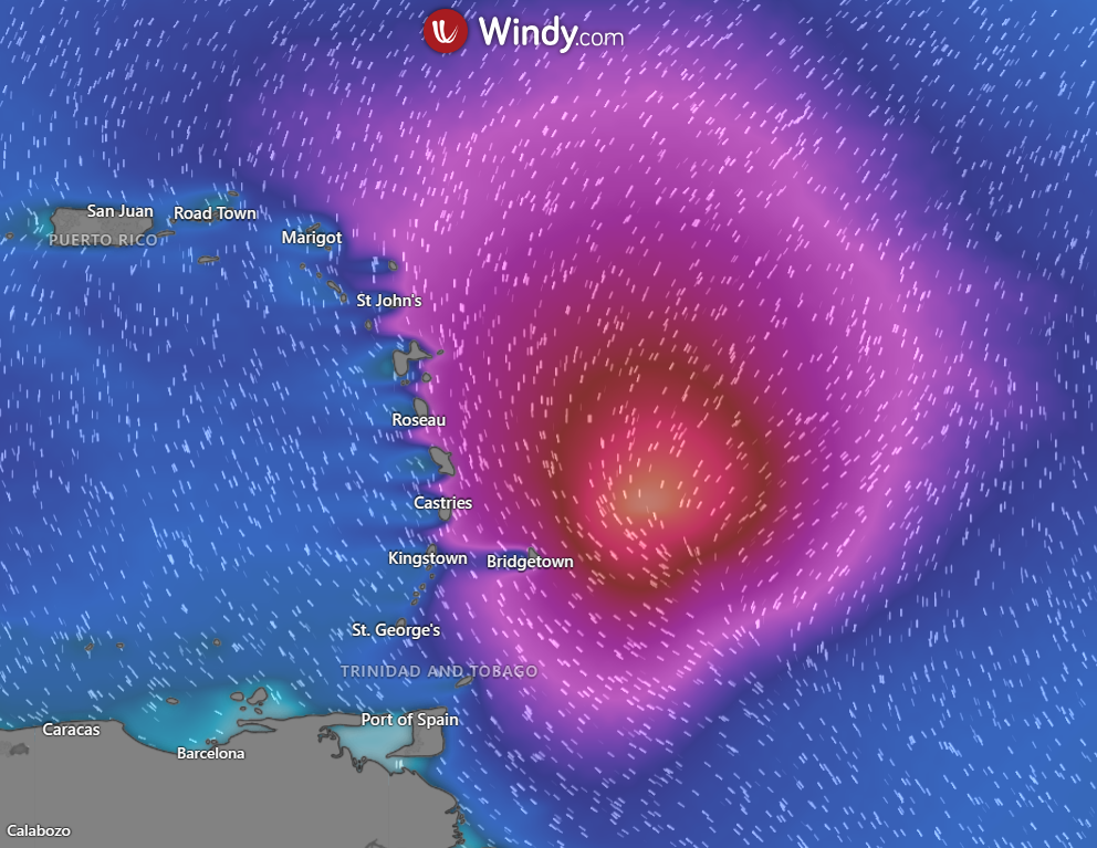
Forecast models are showing waves in open waters are forecast to exceed 2.5 meters and up to 3.5 meters near east-facing coastlines. For areas near the center, waves can reach as high as 6.5 meters (21 feet) in open waters. These higher seas are forecast to remain well north of Trinidad and Tobago, with hazardous seas likely from St. Vincent and the Grenadines, as well as Barbados northward.
For Trinidad and Tobago
Latest Forecast

Tropical Storm Bret, With No Direct or Significant Impacts, Forecast To Influence T&T’s Weather
Trinidad and Tobago is NOT under any tropical storm or hurricane threat, watch, or warning at this time.
In nearly all forecast model guidance as of 2:00 AM Wednesday, June 21st, 2023, Bret’s center of circulation moves well north of Trinidad and Tobago.
As the system nears on Wednesday night into Thursday, convergence ahead of the tropical cyclone, with winds coming from the northeast to north, moves some of the outer bands across the southern Windwards and Trinidad and Tobago. Then, on Thursday, as the center tracks north of Barbados, showers and thunderstorms move across Trinidad, Tobago, and the southern Windwards from the south to the north, feeding into the circulation (feeder bands and localized climatic effects). By Friday into Saturday, southerly to southeasterly wind flow feeds into the tropical cyclone with showers and thunderstorms trailing, moving across Trinidad, Tobago, and the Windwards again.
On Thursday, due to slack to near-calm winds, localized climatic effects like daytime heating, sea breeze convergence, and orographic effects take over, producing slow-moving showers and thunderstorms that are enhanced by topography. These effects can trigger locally heavy rainfall, producing street/flash flooding, gusty winds, and other hazardous weather impacts in localized areas while most of the region experience sweltering temperatures.
Pay close attention to official forecasts in the coming days from your respective authorities. For Trinidad and Tobago, official forecasts and early warnings come from the Trinidad and Tobago Meteorological Service.


