


Tropical Storm Bret’s center has moved near Barbados and now moving across St. Vincent, with the strongest winds affecting northern St. Vincent, St. Lucia, and Martinique on Thursday night. Wind gusts up to 115 KM/H have been recorded, with damage reported on St. Vincent, St. Lucia, Martinique, and Barbados in Bret’s wake.
Although Bret is forecast to weaken in the coming hours, heavy rainfall is still forecast across the central Lesser Antilles as much of the remaining convection is displaced east of the center and yet to track across the region.
While Tropical Storm Bret poses no direct threat to Trinidad and Tobago, a southeasterly flow of winds and moisture trailing Bret on Friday is forecast to support showers and thunderstorms that may produce locally heavy rainfall and wind gusts to 50 KM/H.
What you need to know
— What has changed: Tropical Storm Bret’s center of circulation has remained south of the initial track, now moving across northern St. Vincent and St. Lucia. Bret remains a strong tropical storm and is now moving in the eastern Caribbean Sea. Tropical storm conditions are affecting all islands that are under a tropical storm warning on Thursday night.
— Where is it forecast to move: Bret is forecast to continue moving quickly westward at 30 KM/H into the eastern Caribbean Sea. However, much of the strongest winds remain north of the center of circulation, while much of the convection (showers and thunderstorms) are still to the east of the center.
— The Intensity & Impacts: Islands northward of St. Vincent and Barbados and southward of Dominica remains at the highest risk for damaging winds, flooding rainfall, storm surge, and hazardous seas. Tropical Storm Bret is producing sustained winds up to 95 KM/H and gusts to 110 KM/H, moving across the central Lesser Antilles. For the southern Windwards, southward of St. Vincent and the Grenadines, as well as Barbados to Trinidad and Tobago, feeder bands on Friday could extend southward, bringing showers/thunderstorms and gusty winds, with increased winds from the southeast on Friday.
— Latest from officials: A Tropical Storm Warning remains in effect for St. Vincent and the Grenadines, St. Lucia, Martinique, Dominica, and Barbados. There are no alerts, watches, or warnings in effect for T&T.
The latest

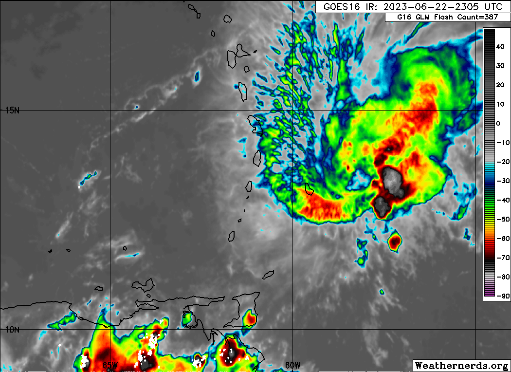
At 11:00 PM Thursday, June 22nd, 2023, Tropical Storm Bret’s approximate center of circulation was located at 13.3°N and 61.1°W, placing the center approximately 55 kilometers south of St. Lucia.
According to the National Hurricane Center’s 11:00 PM Advisory, Tropical Storm Bret is moving west at 30 KM/H, and this general motion is expected during the next couple of days. On the forecast track, the center of Bret is expected to move through and away from the Windward Islands during the next several hours and then move westward across the eastern and central Caribbean Sea Friday and Saturday.
Maximum sustained winds have decreased to 95 KM/H with gusts to 110 KM/H. Gradual weakening is anticipated over the next couple of days, and the system is likely to dissipate over the central Caribbean Sea Saturday night or Sunday.
Tropical-storm-force winds extend outward up to 185 kilometers from the center. The Hewanorra International Airport in St. Lucia recently reported sustained winds of 67 KM/H and a wind gust of 111 KM/H, associated with a blow-up of convection near the low-level center as the system moved past St. Lucia. Tropical storm conditions are also being reported from Martinique.
Current Watches & Warnings

Tropical Storm Warnings are now in effect for St. Vincent and the Grenadines, St. Lucia, Martinique, Dominica, and Barbados. A Tropical Storm Warning means that tropical storm conditions are expected somewhere within the warning area within 24 hours. In this case, tropical storm conditions are ongoing within the warning area.
The Hurricane Watch was discontinued for St. Lucia at 11:00 PM Thursday, June 22nd, 2023.
There are no alerts, watches, or warnings in effect for Trinidad and Tobago at this time from the Trinidad and Tobago Meteorological Service.
What could be the impacts?

For Barbados and the central Lesser Antilles, tropical-storm conditions are ongoing with sustained winds up to 95 KM/H and gusts to 110 KM/H, which can and have produced wind damage across the islands. Seas are forecast to become hazardous, with forecast rainfall totals likely to produce street/flash flooding and landslides. In this forecast update, we’ve upgraded the forecast impact for St. Lucia to high, as the island faces the most prolonged period of Bret’s strongest winds, heaviest rains, and storm surge.
South of St. Vincent, southward to Tobago (and to a lesser extent Trinidad), and north of Guadeloupe, feeder bands could produce periods of heavy rainfall and gusty winds which would be capable of producing localized wind damage, street/flash flooding, and locally rough/choppy seas.
For the Leewards, as a result of an increased pressure gradient, elevated winds and hazardous seas are possible, affecting islands north and west of Montserrat and Antigua and Barbuda through Friday night, but the risk to public safety is negligible.
For the remainder of the westernmost Greater Antilles, little to no major impacts are forecast.
Wind
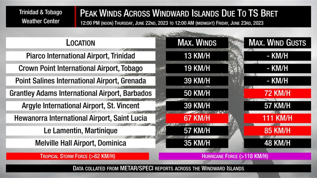
Tropical storm conditions are ongoing across St. Vincent and the Grenadines, St. Lucia, Martinique, Dominica, and Barbados with tropical-storm-force winds and gusts reported.

With feeder bands forecast to traverse much of the eastern Caribbean over the next 24 hours, the National Hurricane Center has much of the Windwards, north of Trinidad and Tobago, experiencing tropical storm-force winds, but higher probabilities exist for the central countries of the island chain.
While Trinidad and Tobago, as well as Grenada and its dependencies, aren’t in the direct line of fire from Tropical Storm Bret at this time, outer bands from the tropical cyclone could still have strong showers and thunderstorms that produce tropical-storm-force wind gusts or sustained winds for brief moments.
Global models continue to show higher winds remaining north of the southern Windward Islands, including Trinidad and Tobago. For Friday, across Trinidad and Tobago, winds are forecast to increase from the southeast, with faster-moving showers and thunderstorms forecast.
Rainfall
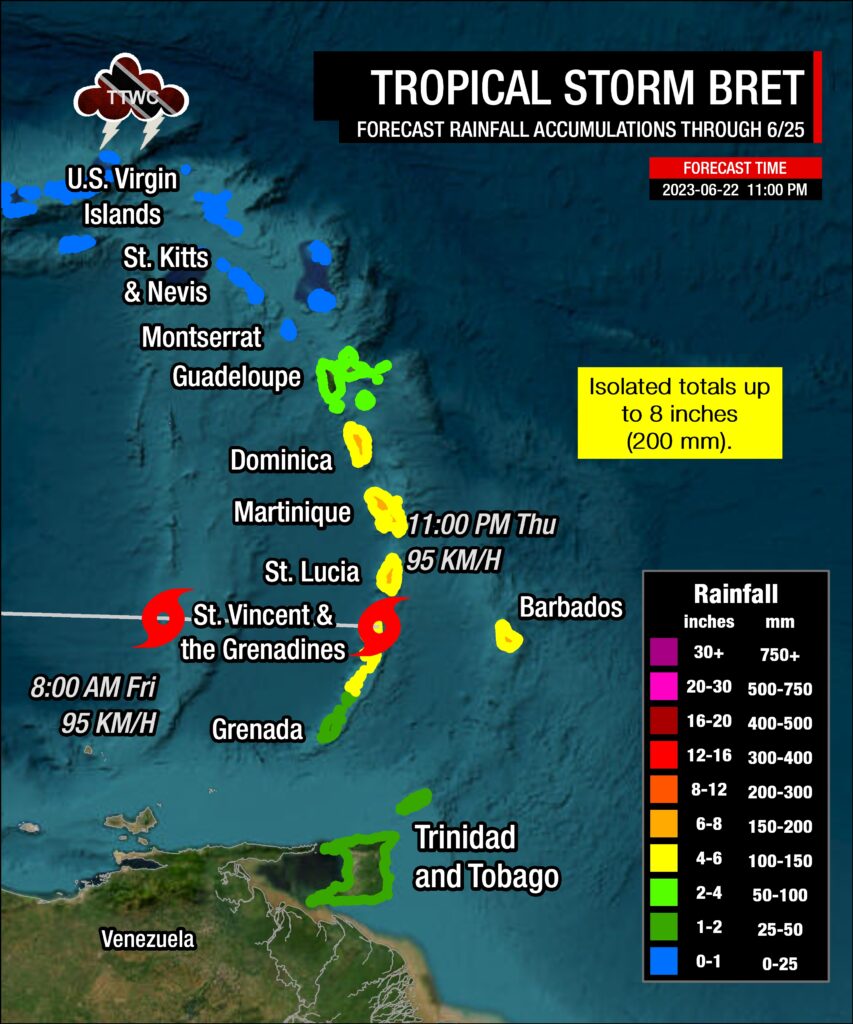
The highest rainfall accumulations are still forecast to occur across Barbados, St. Vincent and the Grenadines, St. Lucia, Martinique, and Dominica, with rainfall totals through Saturday, June 24th, 2023 ranging between 75 and 150 millimeters (3-6 inches) with isolated totals up to 200 millimeters (8 inches).
For Guadeloupe, rainfall totals have decreased, with storm rainfall totals forecast between 50 and 100 millimeters (2-4 inches) and isolated higher totals favoring windward-facing coastlines.
For Grenada, its dependencies, and Trinidad and Tobago, storm rainfall totals are forecast between 25 and 50 millimeters (1-2 inches) and isolated totals up to 100 millimeters (4 inches), favoring windward-facing coastlines and northern areas.
Isolated higher amounts are possible, but the fast-moving nature of Bret is forecast to limit persisting heavy rainfall and higher accumulations.
As mentioned above, feeder bands, convergence associated with Bret, and local topography could produce locally heavy rainfall totals that may trigger localized flooding and mudslides/landslides.
Seas and Storm Surge
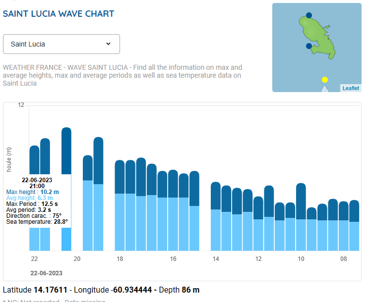
Significant waves have been recorded between St. Lucia and Martinique, with wave heights exceeding 10 meters (33 feet). Storm surge impacts have been reported across Barbados, St. Lucia, and Martinique already.
Generally, the highest waves are forecast between Dominica and St. Vincent and the Grenadines, where wave heights are generally forecast between 5 to 7 meters (16 to 23 feet), but recorded waves have already exceeded these forecasts. North of Trinidad and Tobago, but south of Barbados and St. Vincent, Forecast models are showing waves in open waters are forecast to exceed 2.5 meters (8 feet) and up to 3.5 meters (12 feet) near east-facing coastlines.
For Trinidad and Tobago
Latest Forecast

Tropical Storm Bret, With No Direct or Significant Impacts, Forecast To Influence T&T’s Weather
Trinidad and Tobago is NOT under any tropical storm or hurricane threat, watch, or warning at this time.


