Invest 91L, a tropical disturbance spawned from Tropical Wave 41 east of the Lesser Antilles, is forecast to impact the Windward Islands directly. Though the poorly-defined low-level center is forecast to remain north of T&T, this system is forecast to produce widespread rain, with scattered showers and thunderstorms across Trinidad and Tobago. Similar conditions are possible across the remainder of the Windwards.
Periods of heavy rainfall in shower and thunderstorm activity are possible from Trinidad and Tobago extending northwards to Dominica, accompanied by occasional gusty winds and lightning, while seas are forecast to become agitated.
What you need to know
— What has changed: Showers and thunderstorms have increased with Invest 91L over the last 24 hours, but a Hurricane Hunter flight did not find a well-defined or closed low-level center of circulation. Strong wind shear from the northwest has pushed convection associated with the system south of the center of circulation, placing T&T in the path of the heaviest rains and possibly strong winds.
— Who will be affected: Rainfall associated with this tropical wave and the trailing Intertropical Convergence Zone is forecast to affect the Windward Islands and parts of the French Antilles through Saturday. Namely, islands from Trinidad and Tobago to Dominica, including Barbados, are in the path of this tropical wave’s rainfall and elevated winds.
— What can you expect: Street/flash flooding is highly likely. Chances for riverine flooding will increase through the week for T&T. Gusty winds up to and in excess of 55KM/H accompanying heavy showers or thunderstorms are expected from Trinidad and Tobago towards Dominica. Lightning will accompany thunderstorms. Landslides, mudslides, and rockfalls are possible across the Windwards, with lahars possible in St. Vincent from mid-week. Seas are forecast to become agitated.
— Alerts/Watches/Warnings: The Trinidad and Tobago Meteorological Service (TTMS) issued an Adverse Weather Alert (Yellow Level) for both islands from 5:00 AM Wednesday through 12:00 PM Friday. The Barbados Meteorological Service has issued a High-Surf Advisory and Small Craft Warning for Barbados through 6:00 PM Wednesday and has Barbados under a yellow-level alert for excessive rainfall and winds. St. Vincent and the Grenadines (SVG) Meteorological Services has placed their country under an orange-level Flash Flood Watch, Wind Advisory, and Marine Advisory. Grenada’s Meteorological Service has also issued a warning for flooding, landslides, and a marine advisory. There are no tropical storm or hurricane watches or warnings in effect for any country within the Lesser Antilles at this time.
The latest from the NHC
The National Hurricane Center (NHC) issued two special Tropical Weather Outlooks on Tuesday as satellite imagery showed a rapid increase in convection associated with Invest 91L. However, an aircraft reconnaissance (Hurricane Hunter) flight did not find the organization required to designate the system a tropical depression or tropical storm.
As of their 8:00 PM Tropical Weather Outlook, the NHC says, “A broad area of low pressure located just east of the Windward Islands continues to produce a large area of showers and thunderstorms. Earlier data from the Air Force Reserve Hurricane Hunters indicated that the system did not yet possess a well-defined circulation center, with the majority of the shower and thunderstorm activity displaced to the southeast of the broader rotation.”
They added, “However, upper-level winds are forecast to become more conducive for development, and a tropical depression is likely to form over the next several days if the system remains over open waters while moving westward at about 15 mph through the Windward Islands and into the Caribbean Sea. Another Air Force Reconnaissance mission is scheduled to investigate this system tomorrow morning, if necessary.”
Development chances for tropical cyclone formation have continued to increase over the last 24 hours and are now medium over the next 48 hours and high over the next five days, at 60% and 80%, respectively.
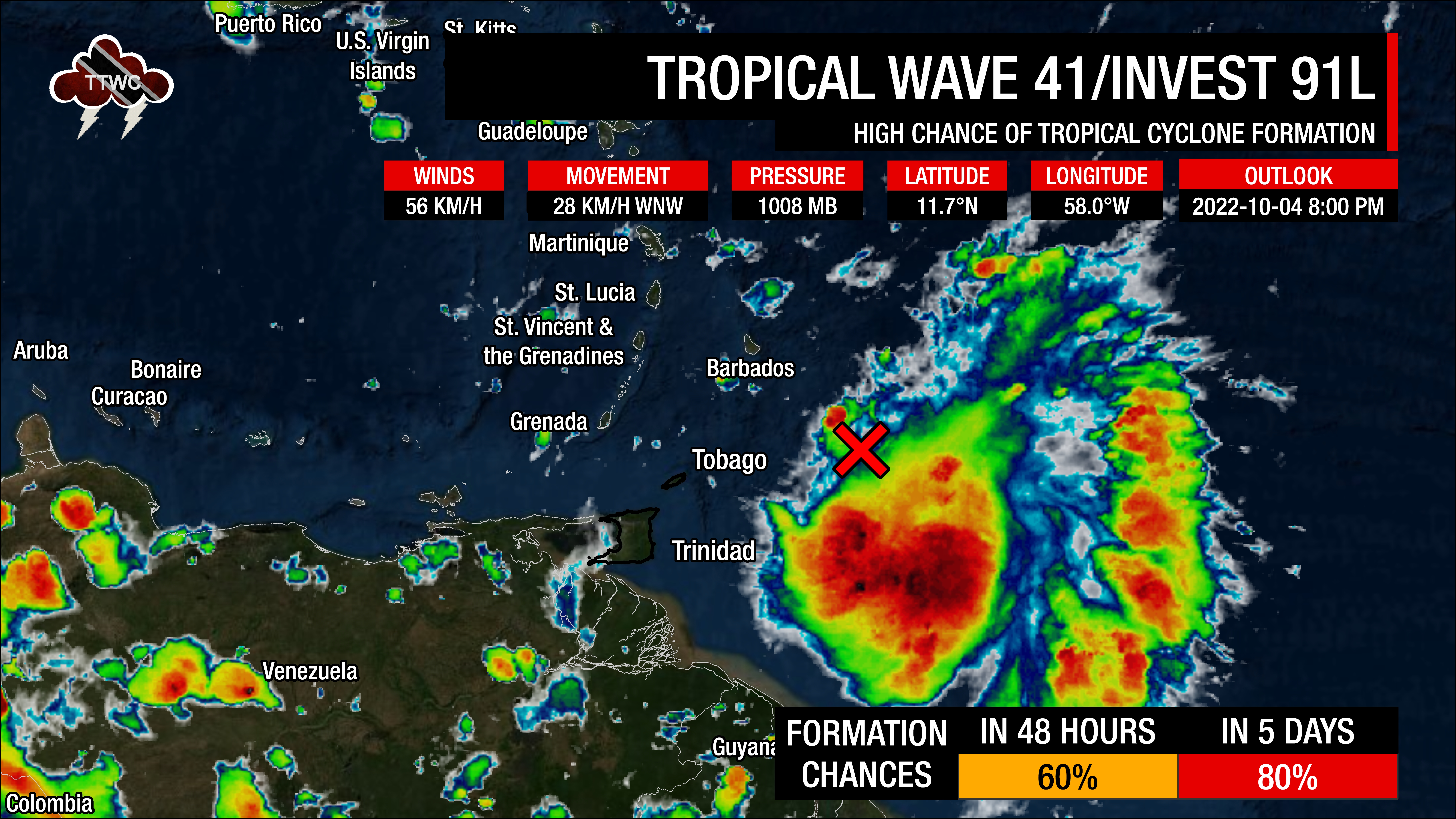
Invest 91L’s center is located approximately 290 kilometers northeast of Tobago or 350 kilometers northeast of Toco, Trinidad, with the leading edge of cloudiness, showers, and thunderstorms just over 100 kilometers east of the country.
The latest data indicate this system is producing sporadic areas of sustained winds of 56 KM/H with higher gusts and a minimum central pressure of 1008 millibars.
Invest 91L’s Forecast
When tropical systems near the Lesser Antilles, all eyes go on the track of the system’s center. However, when these tropical disturbances are weak and disorganized, several things occur:
- The weaker or more disorganized the system is, the more west it travels. Stronger or more organized systems generally take a poleward (northward or northwestward) path.
- Stronger winds generally favor the northern portion of the wave axis or weak circulation. In contrast, the southern portion of the wave or circulation has light to near calm and variable winds.
- Disorganized systems are mainly a rainfall threat over a large area, with sporadic and locally high rainfall totals.
Invest 91L, even with the burst of convection today, has failed to organize considerably. Strong upper-level winds have displaced heavier showers and thunderstorms to the circulation’s south and east. In this area of heavy showers and thunderstorms, sustained winds of 56 KM/H have been recorded.
While the center is moving west-northwest, the remainder of convection is moving general westward and near Trinidad and Tobago. With this latest development, as the low-level center tracks closer to Barbados, the cluster of convection east of T&T moves the area of heaviest rains and stronger winds closer to the country – a marked change from all previous model runs and forecasts.
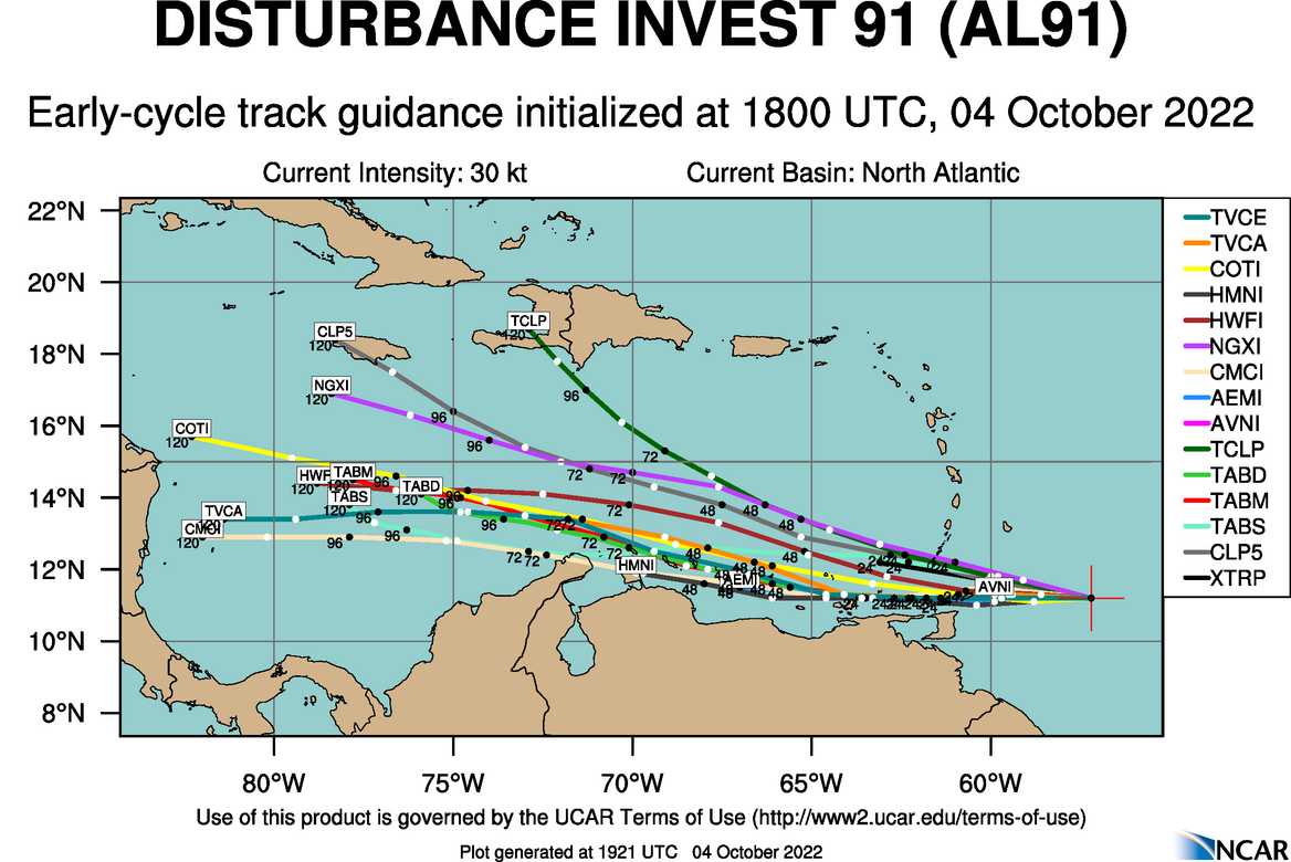
Models continue to handle this system quite poorly, even with the latest runs on Tuesday evening. While upper-level winds are favorable for shower and thunderstorm development, wind shear is forecast to remain moderate from the northeast and east, keeping the strongest showers and thunderstorms displaced southeast of the center. Invest 91L is forecast to traverse very warm sea-surface temperatures between 28°C and 30.5°C on its Windward Islands approach and into the eastern Caribbean.
Deep-layered moisture is present across the Windwards, with precipitable water values exceeding 2 inches (50 millimeters) through the week. Combined with a favorable upper-level environment and deep-layered trough, these factors will support scattered showers and periods of rain, with isolated showers and thunderstorms producing heavy/violent rainfall rates.
The Intertropical Convergence Zone is forecast to move north across the Windwards as this wave traverses the region, supporting showers and thunderstorms through the end of the week.
Later this week into the weekend, Invest 91L could develop further into a tropical depression or tropical storm as it moves across the Southern Caribbean Sea. According to the NHC, “Regardless of development, heavy rainfall with localized flooding, as well as gusty winds, are expected over portions of the Windward Islands, northern portions of South America, and the ABC Islands during the next couple of days. Interests in those locations, in addition to those in Central America, should continue to monitor the progress of this system.”
Invest 91L’s hazards
Given the fairly slow westward movement and largely disorganized nature of the low-pressure area, rainfall and gusty winds are forecast to affect a broad area of the Windwards. Islands from Trinidad and Tobago to Dominica, including Barbados, are in the path of this tropical wave’s rainfall, with elevated winds forecast to affect islands between Trinidad and Tobago toward Dominica.
Islands between Trinidad and Tobago, extending northwards to Dominica, including Barbados, should all be monitoring this system and closely monitoring the meteorological alerts, watches, and warnings from your local meteorological offices.
Rainfall and Flooding
Invest 91L is primarily a rainfall threat to the eastern Caribbean.
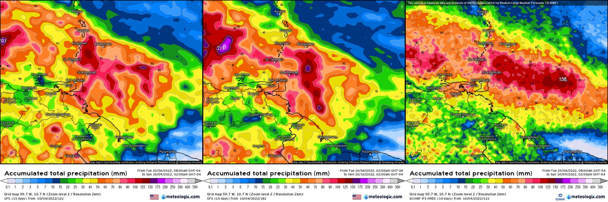
Between 25 and 75 millimeters of rain through Saturday is forecast across the Eastern Caribbean southward of Dominica. Isolated higher totals between 75 and 150 millimeters are possible, particularly across islands’ Windward (or Atlantic-facing) slopes. Specifically for Trinidad and Tobago (Updated as of 2:00 AM Wednesday), overall rainfall totals of up to 150 millimeters are forecast across both islands over the next five days. Isolated totals of up to 200 millimeters are forecast across the southern and eastern areas of both islands.
Putting the rainfall forecast into context, rainfall rates in excess of 50 millimeters per hour or areas that receive in excess of 25 millimeters within an hour tend to trigger street flooding across the country or flash flooding in northern Trinidad. For riverine flooding to occur, a large area of the country (not just in highly localized areas of western coastal Trinidad) would have to record upwards of 75 millimeters within 24 hours, and rainfall would have to fall across major rivers’ catchment areas.
For all islands, street/flash flooding is like to accompany showers and thunderstorms with heavy to violent rainfall rates. Trinidad’s chances for riverine flooding will increase through Wednesday and Thursday as soils become increasingly saturated and rains continue.
Wind
With shear pushing Invest 91L’s convection southeast of the poorly-defined low-level center, Trinidad and Tobago is in the path of experiencing stronger winds than previously forecast.
Elevated winds associated with Invest 91L are forecast to affect islands between Trinidad and Tobago, northward to Dominica. Sustained winds are forecast between 25 KM/H and 40 KM/H, with gusts occasionally exceeding 55 KM/H, generally accompanying showers or thunderstorms.
Possible impacts include localized wind damage to trees, power lines, and small structures. Light outdoor objects may topple or become airborne such as garbage cans, potted plants, loose galvanize or construction material, and other outdoor furniture. Tents may jump. Older/weaker trees may fall, bringing down utility poles and lines.
Seas & Surf
Seas across Trinidad and Tobago are forecast to be agitated but generally remain moderate in open waters with waves up to 2.5 meters. North of T&T and particularly seas east and north of Barbados, waves in open waters could exceed 3.0 meters.
These waves can produce hazardous marine conditions for small craft and sea bathers.
Landslides
With the forecast rainfall accumulations, landslides, mudslides, and rockfalls are possible across islands from Guadeloupe to Trinidad and Tobago. Lahars are also possible in St. Vincent’s orange and red zones.
Tornadoes
A few funnel clouds are possible, mainly through Friday, due to variable winds, particularly across Trinidad and Tobago, as well as Grenada and its dependencies. If a funnel cloud touches down on a body of water, it becomes a waterspout; if it touches down on land, it becomes a tornado.
What should you do?
As an individual, there are a couple of things you can do as we head through the peak of the 2022 Atlantic Hurricane Season:
- Stock your emergency kit
- Clean your surroundings and gutterings
- Secure light or loose objects outdoors
- If your roof is unsecured, purchase and install hurricane straps
- Clear larger trees near your home
- Ensure you have batteries and battery packs for your flashlights, radios, and mobile devices
- Ensure you have sufficient gas for gas-powered stoves and vehicles
- Ensure you have adequate dry foods and water to rally through an extended power outage (generally, the rule of thumb is 72 hours).
- Stock up on candles and mosquito repellant.
- Ensure you have alternative means of communication (like a battery-powered radio) if the internet or television goes down.
- Have a trusted source of information for the latest news before, during, and after a storm.
For the next 24-38 hours, it is important to remain indoors during gusty winds associated with showers and thunderstorms, as light objects outdoors could become airborne. Avoid venturing into flood waters. Plan for your commute and expect traffic disruptions due to fallen trees, landslides, and flooding. Avoid entering the sea if not necessary.
Elsewhere in the Atlantic
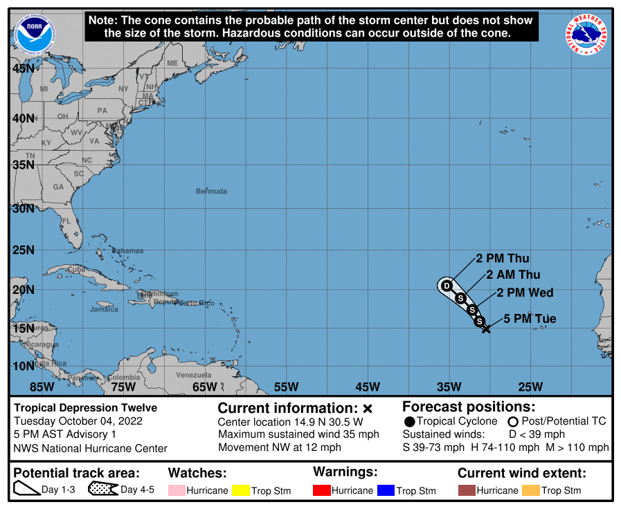
Looking further east, the National Hurricane Center has designated Invest 92L/Tropical Wave 42 as Tropical Depression Twelve on Tuesday afternoon.
At 5:00 PM AST, the center of Tropical Depression Twelve was located near latitude 14.9 North and longitude 30.5 West. The depression is moving toward the northwest near 19 KM/H. A fairly constant motion toward the northwest or north-northwest is expected through Thursday.
Maximum sustained winds are near 55 KM/H with higher gusts. Little change in strength is forecast during the next couple of days, but the depression has some potential to become a tropical storm tonight or on Wednesday. The system is expected to dissipate by Thursday night. Julia and Karl will be the next named storms for 2022 in the Atlantic basin.