


Two tropical waves between Trinidad and Tobago and the African Coast are forecast to move across the region in the coming five days, with the closest wave moving across the country on Saturday, June 3rd, 2023. As we head into June, tropical waves are forecast to become more frequent, moving across T&T every few days.
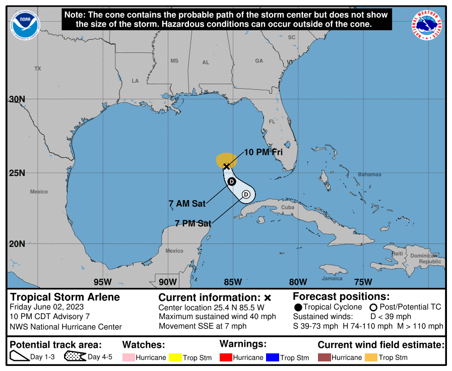
Meanwhile, in the Gulf of Mexico west of Florida, the National Hurricane Center is monitoring Tropical Storm Arlene, which is barely hanging on as a tropical storm.
What you need to know
— Tropical Wave 07: The axis of this tropical wave is located along 55W, moving west at 10 knots (18 KM/H). This wave is forecast to move across T&T and the Windwards on Saturday, June 3rd, 2023.
— Tropical Wave 08: This wave was dropped from the surface analysis.
— Tropical Wave 09: The axis of this tropical wave is located along 37W, moving west at 10 to 15 knots (18-27 KM/H). This wave is forecast to arrive across the southern Windward islands by late Tuesday, June 6th, 2023, into Wednesday, June 7th, 2023.
— Tropical Storm Arlene: The NHC is monitoring a weak tropical storm, forecast to weaken through Saturday, June 3rd, 2023 northwest of Cuba and west of Florida.
— Hazards: For Trinidad and Tobago, scattered showers, periods of rain, and isolated thunderstorms are all forecast, mainly on Saturday, with isolated afternoon activity thereafter. Localized street/flash flooding, landslides, and gusty winds are likely. However, total rainfall accumulations are not forecast to be extreme, likely due to the concentrations of Saharan Dust that are forecast to be present. Still, as we head into next week, river levels are set to become increasingly elevated, with smaller streams becoming overwhelmed. See the forecast for more information.
— Development Concerns: Elsewhere across the Atlantic, tropical cyclone development is not expected, according to the National Hurricane Center.
Tropical Wave 07
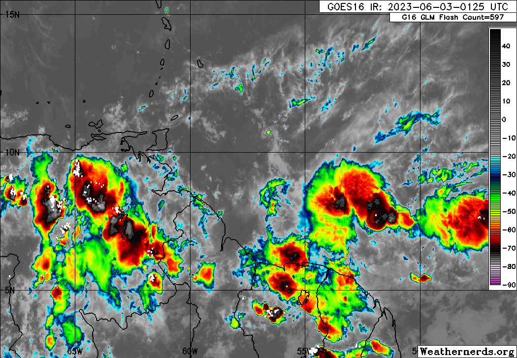
The axis of Tropical Wave 07 along 55W on Saturday, June 3rd, 2023, with scattered moderate to isolated strong convection between 7N and 10N, between 55W and 45W, east of Trinidad and Tobago. (Weathernerds.org)
The seventh tropical wave for the 2023 Atlantic Hurricane season was analyzed along 55W, moving west at 10 knots (18 KM/H). Tropical Wave 08 to the east dissipated, but its moisture field caught up to TW07.
On early Thursday morning, wind shear across Trinidad and Tobago and ahead of the wave axis was minimal, less than 10 knots, and abundant, deep tropical moisture was present. However, the upper-level environment remains hostile across Trinidad and Tobago with favorable upper-level divergence east of the wave axis. Low-level convergence generally hugs the northern coast of South America, south and east of T&T.
As this wave moves slowly west on Saturday, the atmosphere is forecast to remain very moist with relative humidity values above 80%, with near-saturated air at mid to upper levels, resulting in abundant cloudiness. In addition, forecast models indicate moderate instability across Trinidad and Tobago on Saturday with conditions generally favorable for heavy showers and isolated to scattered thunderstorms.
In addition, the Intertropical Convergence Zone is forecast to be pulled northward and remain just south of Trinidad through the weekend.
Tropical Wave 09
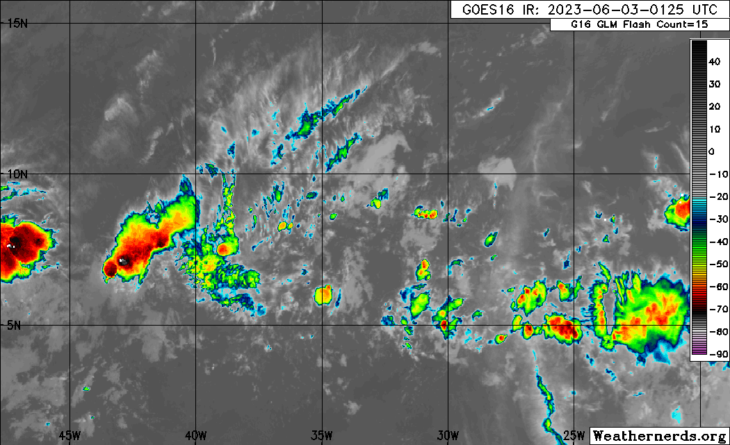
The ninth tropical wave for 2023 is leaving the African coast with scattered weak to moderate convection both ahead and trailing the wave axis. As of 2:00 AM Saturday, the axis of this tropical wave is located along 37W, moving west at 10 to 15 knots (18 to 27 KM/H).
Trade winds are forecast to remain weak across the Atlantic over the next several days, leading to weaker steering currents for this tropical wave. As a result, this tropical wave is forecast to move slowly as it moves across the Atlantic Ocean, with forecast models showing the wave and associated moisture plume reaching across the Windwards by June 6th into June 7th, in tandem with moderate to high concentrations of Saharan Dust present, which could weaken the wave.
While longer-range forecast models show a deep plume of moisture moving across much of the southern Windwards, rainfall totals are forecast to generally remain below one inch (25 millimeters).
Tropical Storm Arlene

The National Hurricane Center (NHC) is issuing advisories on Tropical Storm Arlene, west of Florida.
More on Arlene

Tropical Storm Arlene Forms In The Gulf of Mexico
Trinidad and Tobago is NOT under any tropical storm or hurricane threat, watch, or warning at this time. This system poses no threat to Trinidad, Tobago, and the remainder of the Eastern Caribbean.
Not Every Tropical Wave Brings Severe Weather
Tropical waves vary in intensity as it travels westward across the Atlantic. This variability can be on the order of days to as short term as hours. Sometimes, you may see satellite imagery that shows heavy thunderstorms and deep convective activity east of Trinidad and Tobago during the late night and early morning, but by daybreak – nothing.
This is due to diurnal (daily) variations in convective showers whereby convection peaks overnight and wanes during the day for already occurring convective systems (i.e., not triggered by daytime heating).
Activity can be enhanced by its proximity to upper-level troughs and the ITCZ but can also be degraded by hostile upper-level conditions and Saharan Dust.


