


A robust tropical wave emerged off the African Coast on Thursday, June 15th, 2023, and it has been under close observation since by the National Hurricane Center for tropical cyclone development over the next five to seven days.
Now dubbed Invest 92L, tagged as an area of investigation, it is still six to seven days away from the Lesser Antilles. It has the potential to bring gusty winds, rainfall, and agitated seas to parts of the island chain by the end of the upcoming week.
What you need to know
— Where is Invest 92L: The tropical disturbance is located at 10°N, 27.4°W along Tropical Wave 15 in the far eastern Atlantic Ocean. This current location places Invest 92L, approximately 775 kilometers southwest of the Cabo Verde Islands, over 3,600 kilometers east of Trinidad and Tobago, and just over 3,500 kilometers east-southeast of Barbados.
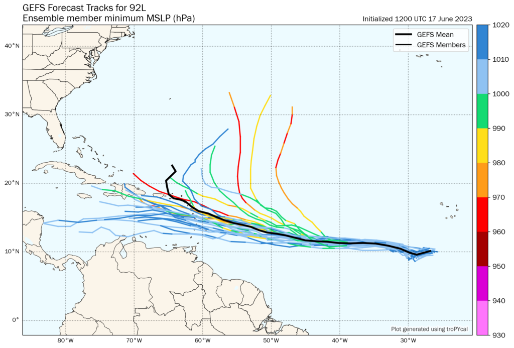
— Where is it forecast to move: This system is still between six and seven days away from nearing the Lesser Antilles, so there is high uncertainty. Based on forecast models as of 2:00 PM Saturday, June 17th, 2023, a weaker low-pressure system could move through the northern Windwards and Leewards while a stronger system could move out to sea, away from the Leewards. Given this system has not yet been formed, there is a large spread among forecast tracks.
— Where could be the impacts: It is too soon to tell. A weaker system (a strong tropical wave or a tropical storm) could bring heavy rainfall, gusty winds, and agitated seas to primarily the northern half of the Lesser Antilles while the southern half, including the southern Windwards and T&T, mostly dry weather. A stronger system (a strong tropical storm or hurricane) could move out to sea, producing light winds across the Lesser Antilles but swells that will impact north/east-facing coastlines.
— Latest from officials: The National Hurricane Center, as of 2:00 PM Saturday, June 17th, 2023, has given a 50% (medium) chance of development over the next two days and a 70% (high) chance of development over the next seven days. Development is likely to occur during the early to middle part of the upcoming week.
The latest
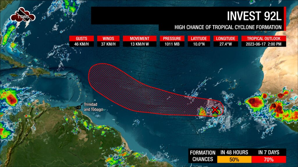
Invest 92L is located 10°N, 27.4°W along Tropical Wave 15 in the far eastern Atlantic Ocean. This current location places Invest 92L, approximately 775 kilometers southwest of the Cabo Verde Islands, over 3,600 kilometers east of Trinidad and Tobago, and just over 3,500 kilometers east-southeast of Barbados.
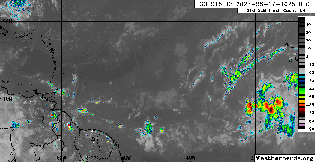
The disturbance is currently producing a broad area of disorganized showers and thunderstorms. Invest 92L is located in an area where sea-surface temperatures are between 27°C and 30°C – some of the warmer waters in the Atlantic. This will provide ample energy for convection to develop in the coming hours, under a relatively low vertical wind shear profile, with favorable low-level convergence and upper-level divergence. Currently, there is little Saharan Dust and dry air present near the wave axis of TW15 and Invest 92L.
According to the National Hurricane Center, environmental conditions appear conducive
for additional development, and a tropical depression is likely to form by the early to the middle portion of next week while the system moves westward at 24 to 32 KM/H across the eastern and central tropical Atlantic.
As of 2:00 PM Saturday, June 17th, 2023, has given a 50% (medium) chance of development over the next two days and a 70% (high) chance of development over the next seven days.
What is an Invest?
In Meteorology, an INVEST (short for an investigative area, also called an area of interest) is a designated area of disturbed weather monitored for potential tropical cyclone formation.
In the Atlantic Basin, these INVESTs are designated by the United States National Hurricane Center, numbered from 90 to 99, followed by the suffix L. These suffixes change for each basin, with “E” and “C” in the Eastern and Central Pacific basins (respectively), or “W” in the Western Pacific basin. Numbers are rotated within the season and are re-used as necessary (the subsequent INVEST after 99 would be numbered 90).
According to the National Hurricane Center, by designating a tropical weather system as an INVEST, the collection of specialized data sets and computer model guidance on the area of interest can begin. This collection and processing of data are shown on several government and academic websites for analysis.
The designation of a system as an INVEST does not necessarily correspond to any particular likelihood of the development of the system into a tropical cyclone.
Where is it going?
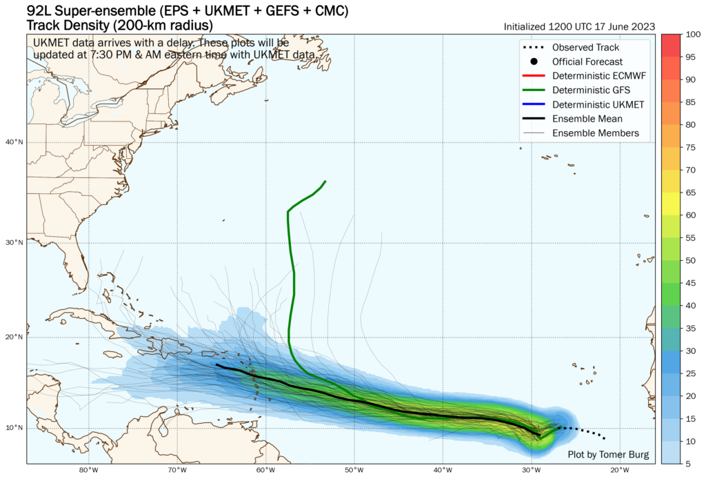
A weaker system will take a more westerly path, driven west by a surface to mid-level high located in the subtropical Atlantic and the trade winds. This would result in the eventual low-pressure system – whether it is a strong tropical wave or modest tropical storm – moving across the northern half of the Lesser Antilles.
A stronger system will recurve out to sea, primarily moving northward (poleward) due to the influence of a mid-level trough in the subtropical/north Atlantic.
But there are many caveats. Firstly, this system has not yet formed a well-defined low-level center for models to track. There are multiple low-level areas of spin as of Saturday afternoon, and depending on where these areas of spin coalesce, we could see changes in the track.
Secondly, if this system develops, depending on where it intensifies, it can recurve out to sea well east of the Lesser Antilles, near the northeastern Lesser Antilles, or there could be no recurve at all.
Thirdly, this system is between six and seven days away from its Lesser Antilles approach, so quite a bit can change between now and next Thursday/Friday.
What could be the impacts?
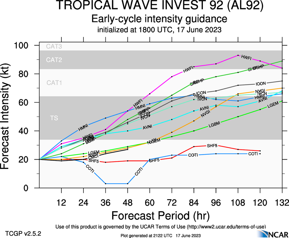
Forecast models are consistently showing development to occur by Monday, June 19th, 2023, with gradual intensification through next week. How much this storm intensifies, changes what impacts the Lesser Antilles could experience.
A weaker system (strong tropical wave or tropical storm), with a more southerly path, brings the heaviest rains and stronger winds across the northern half of the Lesser Antilles, including the northern Windwards and Leewards. Seas will become hazardous, with the possibility of wind damage, flooding, and landslides increasing. Note even with an even more southerly path for the center, the most active weather tends to favor the northern/northeastern portion of the low-pressure systems.
For the southern half of the Lesser Antilles, in this scenario, a low-level trough extending southwestward from this low-pressure system will slacken the pressure gradient across the region, leading to light to near-calm, southerly winds. As a result, localized climatic effects like daytime heating, sea breeze convergence, and orographic effects take over, producing slow-moving showers and thunderstorms that are enhanced by topography. These effects can trigger locally heavy rainfall, producing street/flash flooding, gusty winds, and other hazardous weather impacts in localized areas while most of the region experience sweltering temperatures.
A stronger low-pressure system (stronger tropical storm or hurricane) could also move across the Leewards and produce hazardous seas, strong, damaging winds, and flooding rainfall, with less impactful weather across the Windwards generally.
The strongest storms, based on the latest model guidance, move out to sea with little weather impact on land outside of slackening the pressure gradient across the Lesser Antilles, but swells could create hazardous marine conditions across the northern and eastern coastlines of the islands.
As mentioned above, this range of possibilities will be further refined in the coming days once the track is more confident and a tropical cyclone forms.
What does this mean for T&T?
The most likely scenario for Trinidad and Tobago is one where from Thursday, winds begin to decrease, with the steering flow either weakening to zero or having northerly moving showers and thunderstorms triggered by localized climatic effects. This means we could see localized areas of intense rainfall, street/flash flooding, and gusty winds, while other areas see humid, hot, and settled weather.
As this system moves west (if it tracks across the Leewards), trailing convergence could support scattered showers/thunderstorms across Trinidad and Tobago by Friday, June 23rd, 2023. By Saturday, conditions would begin to settle.
It is important to note again this is for six to seven days away from today, Saturday, June 17th, 2023, when this was written. Quite a bit can change between now and then, so pay close attention to official forecasts in the coming days from your respective authorities. For Trinidad and Tobago, official forecasts and early warnings come from the Trinidad and Tobago Meteorological Service.


