


History has repeated itself six years later, as Tropical Storm Bret formed in the Main Development Region of the Atlantic Ocean at 5:00 PM June 19th, 2023. The National Hurricane Center upgraded Tropical Depression Three, previously Invest 92L, earlier on Monday morning.
The previous Tropical Storm Bret was designated – upgraded from then Potential Tropical Cyclone Two – at 5:00 PM, June 19th, 2017, which then became the earliest named storm to develop in the Main Development Region of the Atlantic basin on record. 2023’s Bret has now tied that record.
However, unlike 2017’s Bret, which took aim at Trinidad and Tobago as a disorganized tropical storm, 2023’s Bret is forecast to take aim at the northern Windwards and Leewards as an organized hurricane by the end of this week. It poses no direct threat to Trinidad and Tobago at this time.
What you need to know
— Where is Tropical Storm Bret: Tropical Storm Bret is located at 11.3°N, 42.2°W central Tropical Atlantic Ocean, placing the center approximately 2,050 kilometers east of Tobago and 1,950 kilometers east of Barbados.
— Where is it forecast to move: Forecast models have honed in on the center of circulation moving between Martinique and St. Lucia, remaining well north of Trinidad and Tobago. A stronger system will move further northwest, while a weaker system will move further west, resulting in some southward adjustment of the track. The current forecast track places the northern and central Windwards and Leewards at the highest risk for damaging winds, flooding rainfall, storm surge, and hazardous seas.
— The Intensity & Impacts: The National Hurricane Center is explicitly forecasting a Category 1 Hurricane to move across the northern and central Windwards, French Antilles, and southernmost Leewards by Friday, June 23rd, 2023. Those areas could see sustained winds up to 130 KM/H and gusts to 160 KM/H, flooding rainfall, storm surge, and hazardous seas. For the southern Windwards, southward of St. Vincent and the Grenadines as well as Barbados to Trinidad and Tobago, while feeder bands could extend southward, bringing showers/thunderstorms and gusty winds, light to near calm winds will lead to increased daytime temperatures, localized, slow-moving afternoon showers and thunderstorms, and agitated seas from Thursday through Saturday.
— Latest from officials: There are no coastal watches or warnings in effect for the Lesser Antilles at this time, but tropical storm and hurricane watches may be issued by Tuesday night for areas with the highest potential for tropical-storm and hurricane-force winds, which is forecast to remain well north of Trinidad and Tobago.
The latest

Tropical Storm Bret was upgraded from Tropical Depression Three at 5:00 PM Monday, June 19th, 2023, with its approximate center of circulation located at 11.3°N and 42.2°W, placing the center approximately 2,050 kilometers east of Tobago and 1,940 kilometers east of Barbados.
According to the National Hurricane Center’s 5:00 PM Advisory, Tropical Storm Bret is moving west at a brisk pace of 35 KM/H, and this is forecast to continue for the next several days, approaching the Lesser Antilles by Thursday into Friday this week.
Maximum sustained winds are now near 65 KM/H with gusts to 75 KM/H, with strengthening forecast this week. The NHC says this system is forecast to become a hurricane in a few days. The current minimum central pressure is 1008 millibars, with tropical-storm-force winds extending outwards up to 75 kilometers from the center.
Tropical Storm Bret is currently producing a broad area of increasingly organized showers and thunderstorms, with the strongest convection near the center of circulation and along the southeast and southwestern quadrants of the storm.
Tropical Storm Bret is located in an area where sea-surface temperatures are between 27°C and 29°C and is forecast to move over some of the warmer waters in the Atlantic. This will provide ample energy for strengthening, under a relatively low vertical wind shear profile, with favorable low-level convergence and upper-level divergence. Currently, there is little Saharan Dust and dry air present ahead of the system, mainly remaining well north of the moisture envelope.
Track and Intensity

A large ridge of high pressure is forecast to take Bret near-westward over the next several days. As the system nears the Lesser Antilles by mid-week, this ridge is forecast to weaken, allowing for a slight west-northwest path.
Where this west-northwest motion begins is crucial in determining where experiences the strongest winds and heaviest rains, which tend to occur north of the center of circulation. The main source of uncertainty is linked to how strong Bret eventually becomes, with a stronger system moving further poleward (northward) while a weaker system maintains a westward path.
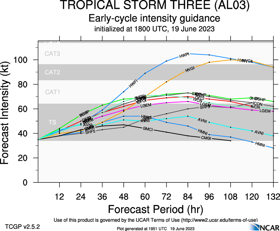
Conditions appear favorable for strengthening with abundant warm sea surface temperatures, light vertical wind shear, and sufficient low to mid-level moisture. However, the intensity forecast as it is on the Eastern Caribbean’s doorstep becomes uncertain. An upper-level trough is forecast to impart elevated wind shear on Bret by late Wednesday into Thursday, with an increase in dry air into its environment leading to some weakening, particularly as it moves in the Caribbean Sea. Hurricane and regional models are trending towards a stronger system, while global models (European, American, and U.K.) show a weaker system.
The National Hurricane Center’s forecast, which historically outperforms model guidance, shows Bret moving through the French Antilles on Thursday afternoon into Friday morning as a Category 1 Hurricane, with sustained winds up to 130 KM/H and gusts to 160 KM/H.
However, the NHC notes that, at this time, this remains a low-confidence forecast. Given this system is still two to four days away, there could be additional southward or northward adjustments. Over the last 24 hours, model guidance has shifted southward for the center of circulation, with current consensus modeling remaining marginally southward of the NHC’s forecast, with the center still remaining north of Barbados and St. Vincent and the Grenadines.
What could be the impacts?
Wind
As mentioned above, the National Hurricane Center is forecasting, as of 5:00 PM Monday, June 19th, 2023, a Category 1 Hurricane with sustained winds up to 130 KM/H and gusts to 160 KM/H moving across the French Antilles, mainly between St. Lucia and Guadeloupe.
However, the forecast model guidance remains widely spread – with some showing a tropical storm with winds near 40 knots (65 KM/H) to a Category 1 Hurricane with winds to 70 knots (130 KM/H).
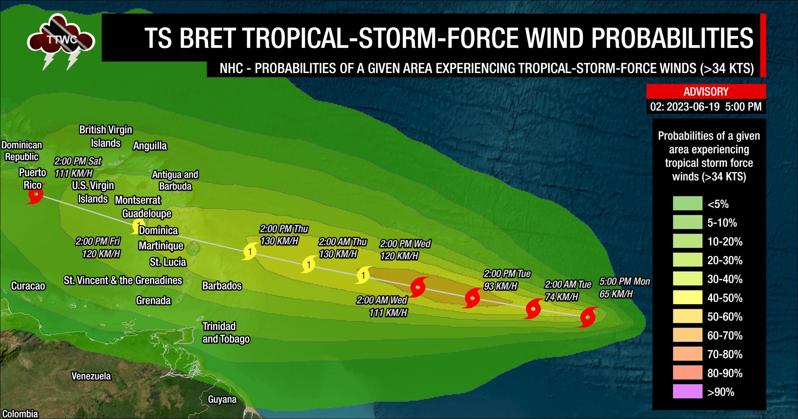
With tropical cyclones, the stronger winds generally remain on the northern half of the system’s circulation, meaning the Leewards like Antigua and Barbuda, as well as St. Kitts and Nevis, could see winds of tropical storm strength. Given that there is still some uncertainty with the forecast, the National Hurricane Center has the entire eastern Caribbean area under a low to medium probability of experiencing tropical storm-force winds, but higher probabilities exist for the northern half of the island chain.
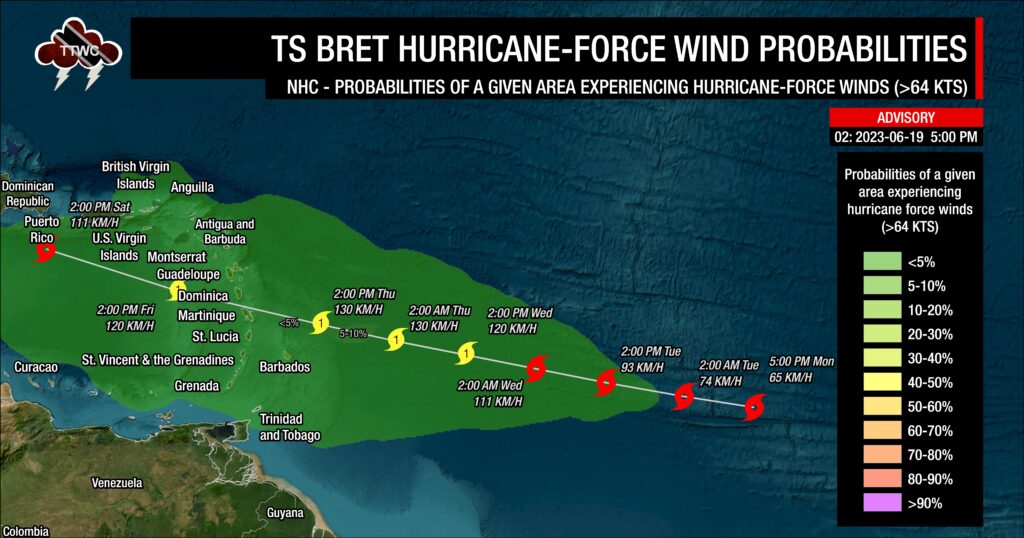
Similarly, when looking at the probability of hurricane-force winds, five days out, there is a very low chance of the eastern Caribbean experiencing hurricane-force winds, but the highest chances exist near the northern Windwards/French Antilles.
While the southern Windwards aren’t in the direct line of fire from Tropical Storm Bret at this time, outer bands from the tropical cyclone could still have strong showers and thunderstorms that produce tropical-storm-force wind gusts or sustained winds for brief moments – hence the risk is not zero.
Global models, which keep Bret weaker, show higher winds remaining north of southern Windward Islands, including Trinidad and Tobago. As mentioned earlier, when strong low-pressure systems (strong tropical waves, tropical storms, or even hurricanes) move sufficiently north of T&T, the winds across Trinidad and Tobago become light to near-calm as the pressure gradient across the area slackens.
Rainfall
Generally, rainfall totals associated with Bret are forecast to range between 50 and 150 millimeters (2-6 inches), with higher totals up to 300 millimeters (12 inches) along Windward facing coastlines near the center of circulation. Isolated higher amounts are possible, but the fast-moving nature of Bret is forecast to limit persisting heavy rainfall and higher accumulations.
Where the heaviest rains fall is contingent on the track, and there’ll be some increasing clarity on this as we progress through the week. Ultimately, all islands across the Lesser Antilles should remain on guard for some form of flooding rainfall associated with this tropical cyclone later this week, whether there is a direct impact or not.
Seas and Storm Surge

Similar to the rainfall totals, how agitated seas become and the level of storm surge is dependent on the strength of the tropical cyclone.
On the weaker end of the spectrum, with a tropical storm moving across the northern half of the Lesser Antilles, waves in open waters could reach up to 4.5 meters (15 feet) and up to 4 meters near east-facing coastlines. For a stronger storm, waves can reach as high as 6.5 meters (21 feet) in open waters. These higher seas are forecast to remain well north of Trinidad and Tobago, with hazardous seas likely from St. Vincent and the Grenadines, as well as Barbados northward.
This forecast will also be refined in the coming days as certainty on track and intensity improves.
For Trinidad and Tobago
Forecast models are consistently showing gradual intensification through this week. How much this storm intensifies, changes what impacts the Lesser Antilles could experience.
In nearly all forecast model guidance as of 2:00 PM Monday, June 19th, 2023, Bret’s center of circulation moves well north of Trinidad and Tobago. The southernmost models place the center near Barbados, while the northernmost models have the center tracking near Antigua and Barbuda.
For the southernmost scenarios – as the system nears on Wednesday night into Thursday, convergence ahead of the tropical cyclone, with winds coming from the northeast to north, moves some of the outer bands across the southern Windwards and Trinidad and Tobago. Then, on Thursday, as the center tracks north of Barbados, showers and thunderstorms move across Trinidad, Tobago, and the southern Windwards from the south to the north, feeding into the circulation (feeder bands and localized climatic effects). By Friday into Saturday, southerly to southeasterly wind flow feeds into the tropical cyclone with showers and thunderstorms trailing, moving across Trinidad, Tobago, and the Windwards again.
Based on the NHC’s forecast and for the northernmost scenarios, a similar situation plays out above with two key differences – less overall rainfall for Trinidad and Tobago and increased southeasterly winds on Saturday, which keeps unsettled conditions just a bit longer.
On Thursday through Saturday, due to slack to near calm winds, localized climatic effects like daytime heating, sea breeze convergence, and orographic effects take over, producing slow-moving showers and thunderstorms that are enhanced by topography. These effects can trigger locally heavy rainfall, producing street/flash flooding, gusty winds, and other hazardous weather impacts in localized areas while most of the region experience sweltering temperatures.
The strongest storms, based on the latest model guidance, move out to sea with little weather impact on land outside of slackening the pressure gradient across the Lesser Antilles, but swells could create hazardous marine conditions across the northern and eastern coastlines of the islands. Within the Gulf of Paria, seas can become agitated due to northerly moving winds.
As mentioned above, this range of possibilities will be further refined in the coming days once the track is more confident and a tropical cyclone forms.
It is important to note that Bret is still three to four days away from today, Monday, June 19th, 2023, when this was written. Quite a bit can change between now and then, so pay close attention to official forecasts in the coming days from your respective authorities. For Trinidad and Tobago, official forecasts and early warnings come from the Trinidad and Tobago Meteorological Service.


