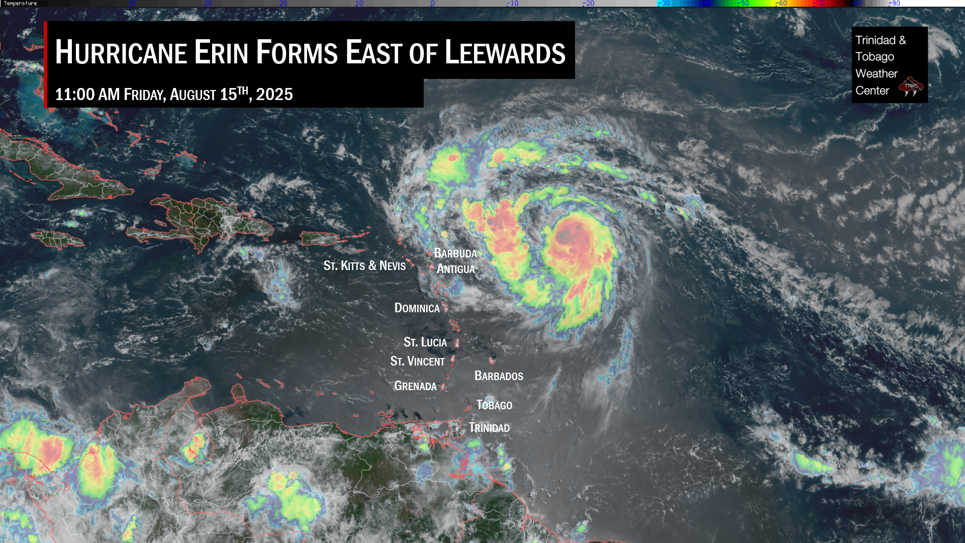
The remnants of Tropical Storm Sean and an active tropical disturbance, Invest 94L, are forecast to bring rainfall to the Lesser Antilles over the next five days. The National Hurricane Center is monitoring Invest 94L for tropical cyclone development, with high chances of formation over the next week.
What you need to know
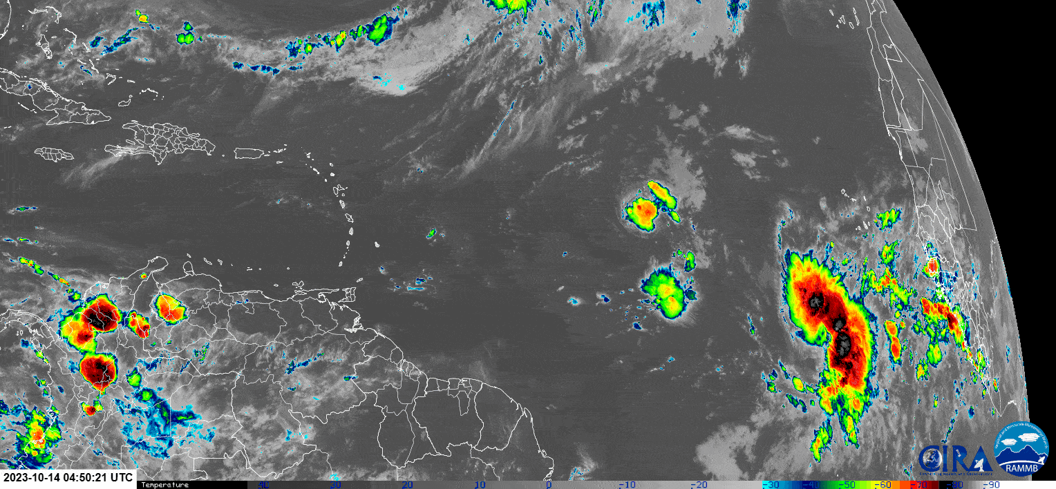
— Ex-TS Sean: The remnants of Tropical Storm Sean are located at 18.58°N, 54°W, with a cluster of convection (showers/thunderstorms) ahead of the trough axis, moving towards the Leeward Islands.
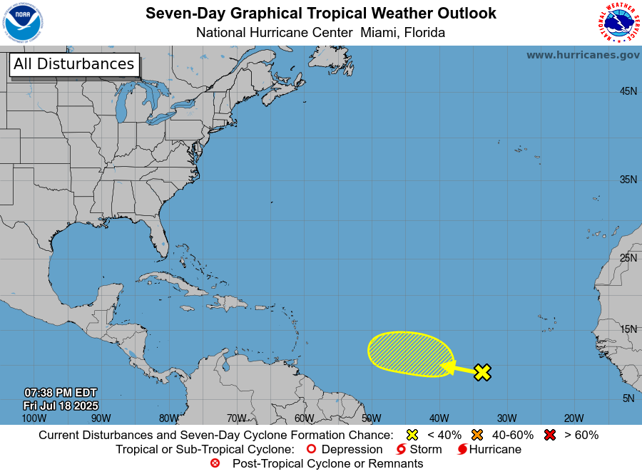
— Invest 94L: This tropical disturbance is located near 10°N, 39.7°W, moving west at 9 knots (17 KM/H). This tropical wave (TW52) has a high chance of tropical cyclone formation over the next seven days and is forecast to move near the Lesser Antilles toward the end of the week.
— Tropical Wave 53: The axis of this tropical wave is located along 38W, moving west at 10 (18 KM/H). This wave’s eventual motion is dependent on the forward speed and track of Invest 94L, with a high level of uncertainty on when (or if) this wave will make it to the region.
— Hazards: For Trinidad and Tobago, rainfall will primarily be due to local atmospheric dynamics influenced by the low-pressure area associated with Invest 94L, daytime heating, sea breeze, and orographic convergence, and the Intertropical Convergence Zone‘s proximity to T&T. See the forecast for more information.
Ex-Tropical Storm Sean
Tropical Storm Sean weakened into a depression on Saturday night, October 14th, 2023, and became a remnant low on Sunday night, October 15th, 2023.
As the remnants encounter a briefly favorable area of lower wind shear (relative to the nearby areas) and upper-level conditions, a flare-up of convection (showers and thunderstorms) has occurred.
However, as the remnant low rides a strong sub-tropical high-pressure system anchored north of the Greater Antilles, this area of moisture and instability is forecast to track just north of the Leewards on Wednesday, producing scattered showers and cloudiness with isolated thunderstorms.
For the remainder of the Lesser Antilles, a line of moisture will support partly to mostly cloudy skies with some scattered showers and isolated thunderstorms generally from the morning through the afternoon. No significant rainfall is forecast across the island chain, with highly isolated areas receiving up to 25 millimeters.
Invest 94L & TW53
The 52nd tropical wave for 2023 is located along 39/40W, moving west at 10 knots (18 KM/H). It currently has a high chance, 80%, of tropical cyclone formation over the next seven days, according to the National Hurricane Center (NHC).
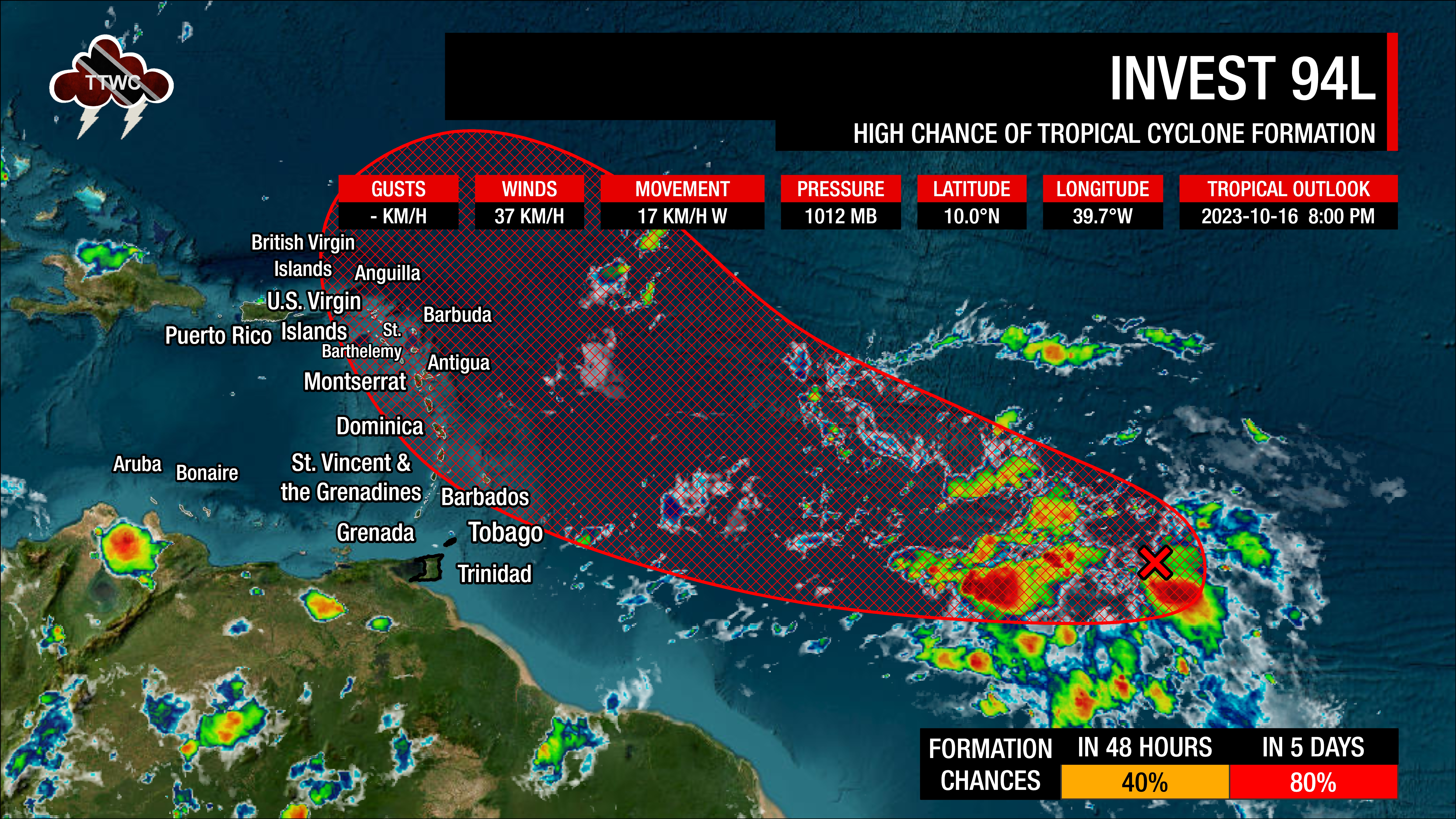
In their 8:00 PM Tropical Update on October 16th, “A broad area of low pressure located over the central tropical Atlantic, about midway between the Windward Islands and the west coast of Africa, is producing a large area of disorganized showers and thunderstorms. Environmental conditions are expected to remain conducive for further development, and a tropical depression will likely form during the next few days. This system is forecast to move westward to west-northwestward across the central and western tropical Atlantic during the next several days.”
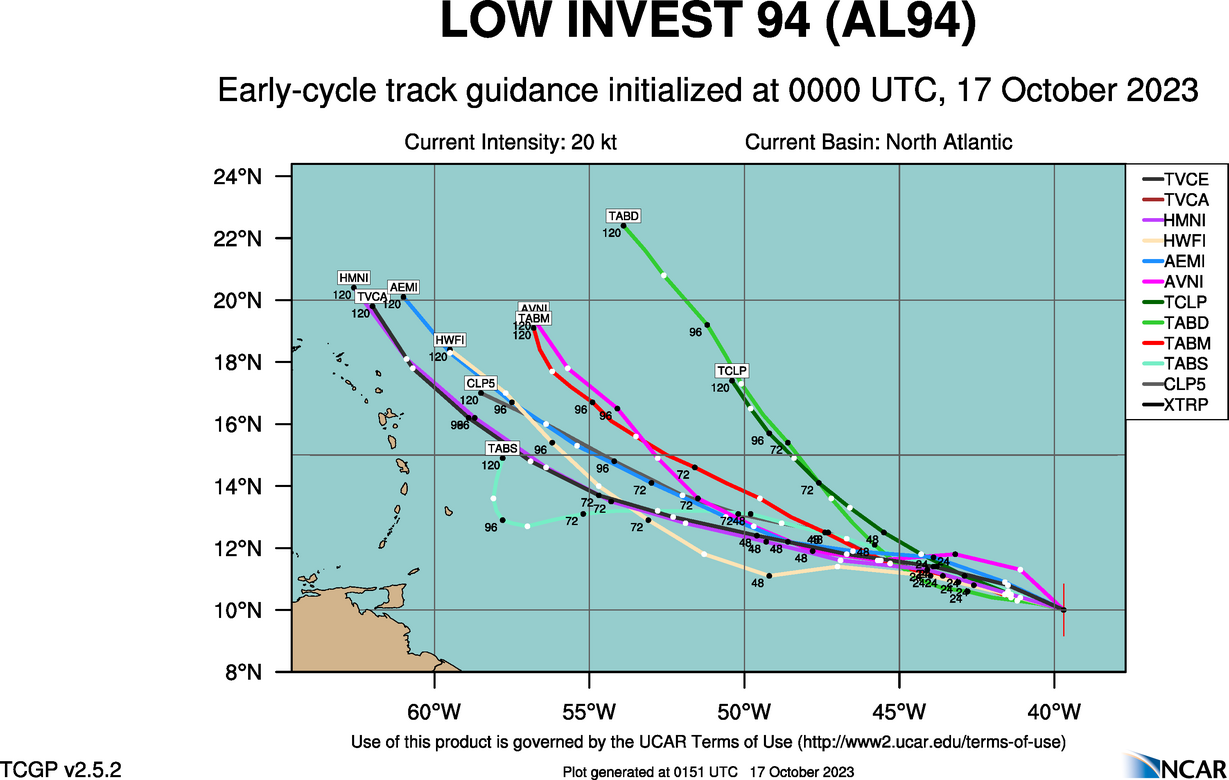
Like ex-Sean, Invest 94L is moving along a deep-layered high-pressure system, taking it mostly westward. As of Tuesday night, forecast models (both global and regional hurricane guidance) show this system developing by Wednesday morning as it begins to take a more northwestward path.
As with systems forming east of the Lesser Antilles, stronger systems tend to curve northwest, while weaker systems generally maintain a westward path. The further west it moves, the more likely rainfall and wind impacts become for the Lesser Antilles, mainly north of Barbados towards the Leeward Islands. There still remains a larger-than-usual spread amongst models, resulting in high uncertainty. For T&T, all forecast models show no significant, widespread rainfall or winds through the end of the upcoming weekend associated with Invest 94L.
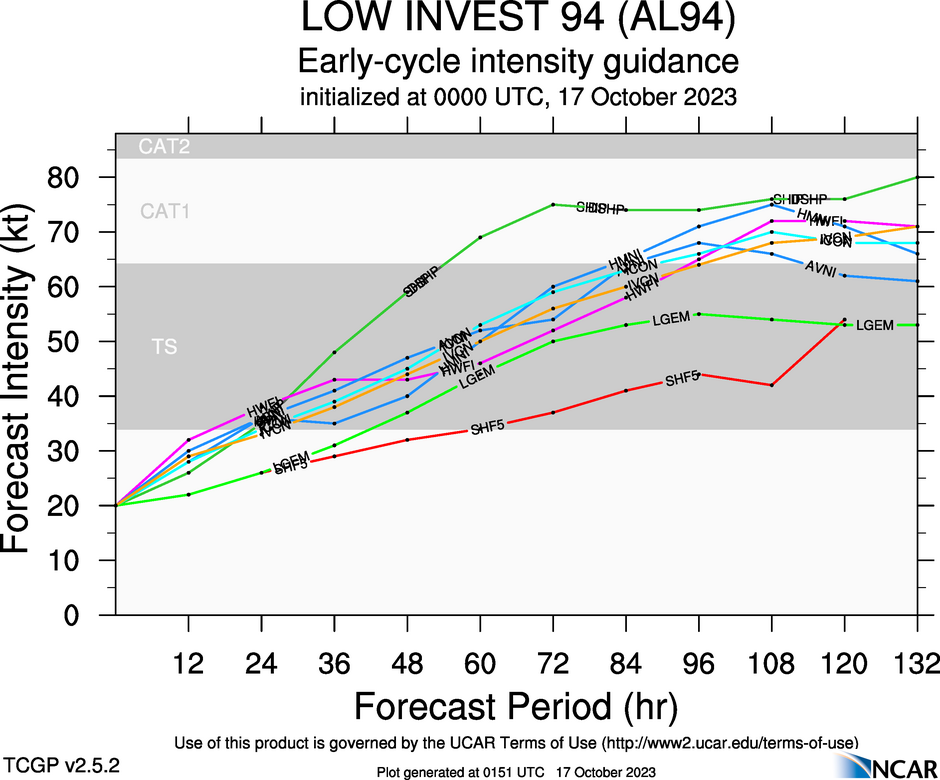
The National Hurricane Center indicates that a tropical depression could form in the next few days, with forecast models showing a tropical storm could develop by Wednesday morning, and it could become a strong tropical storm or borderline Category 1 hurricane by Friday night.
As this system nears the Lesser Antilles and pulls northwest, troughing extending southwest from the system will reduce winds across T&T and the Windwards, with winds moving from the southeast to south, bringing the Intertropical Convergence northward. Forecast models aren’t enthusiastic about significant rainfall, but upper-level conditions will be favorable to enhance convection, leading to locally heavy rainfall or stronger thunderstorms where showers/thunderstorms develop, favoring generally western and hilly areas of the country.
Not Every Tropical Wave Brings Severe Weather
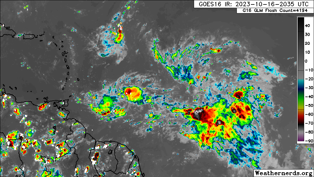
Tropical waves vary in intensity as they travel westward across the Atlantic. This variability can be on the order of days to as short term as hours. Sometimes, you may see satellite imagery that shows heavy thunderstorms and deep convective activity east of Trinidad and Tobago during the late night and early morning, but by daybreak – nothing.
This is due to diurnal (daily) variations in convective showers whereby convection peaks overnight and wanes during the day for already occurring convective systems (i.e., not triggered by daytime heating).
Activity can be enhanced by its proximity to upper-level troughs and the ITCZ but can also be degraded by hostile upper-level conditions and Saharan Dust.
As we progress through October, tropical waves are forecast to gradually decrease in intensity and frequency, but low-level troughs interacting with the ITCZ and occasional tropical wave activity in the past have led to prolific rainfall events in the country.