


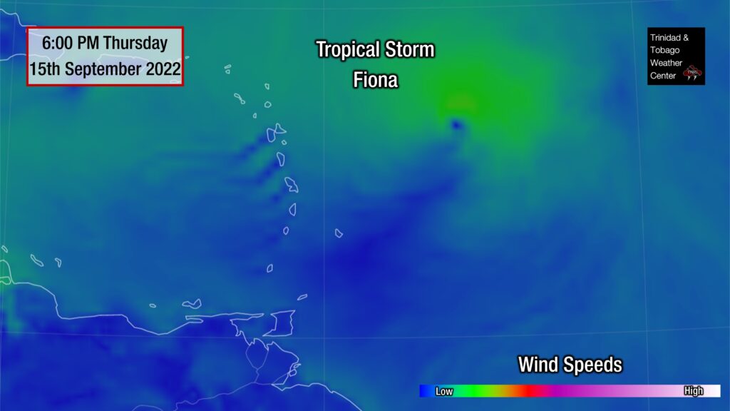
Tropical Storm Fiona has strengthened in the Atlantic Basin, 685 kilometers east of the Leeward Islands, at 5:00 PM Thursday. An Air Force Reserve Hurricane Hunter aircraft is currently investigating the system, which found stronger maximum sustained winds northeast of the center of circulation.
Tropical Storm Warnings have been issued for several islands, including Guadeloupe north to Anguilla and from Antigua and Barbuda, ending east of the Virgin Islands. Tropical Storm Watches are in effect for Puerto Rico and the U.S. and British Virgin Islands.
Over the last 24 hours, Fiona’s center has consistently remained south of the official track. However, it is still forecast to move directly across the Leeward Islands on Friday into Saturday and parts of the Greater Antilles through the weekend.
Specifically for Trinidad and Tobago, while direct impacts are not expected, an atypical wind regime is expected to continue through the weekend, with moisture and light winds moving from the south to the north. This will result in increased maximum temperatures on Friday with showers and isolated thunderstorms possible on Saturday and Sunday.
The Latest From The National Hurricane Center
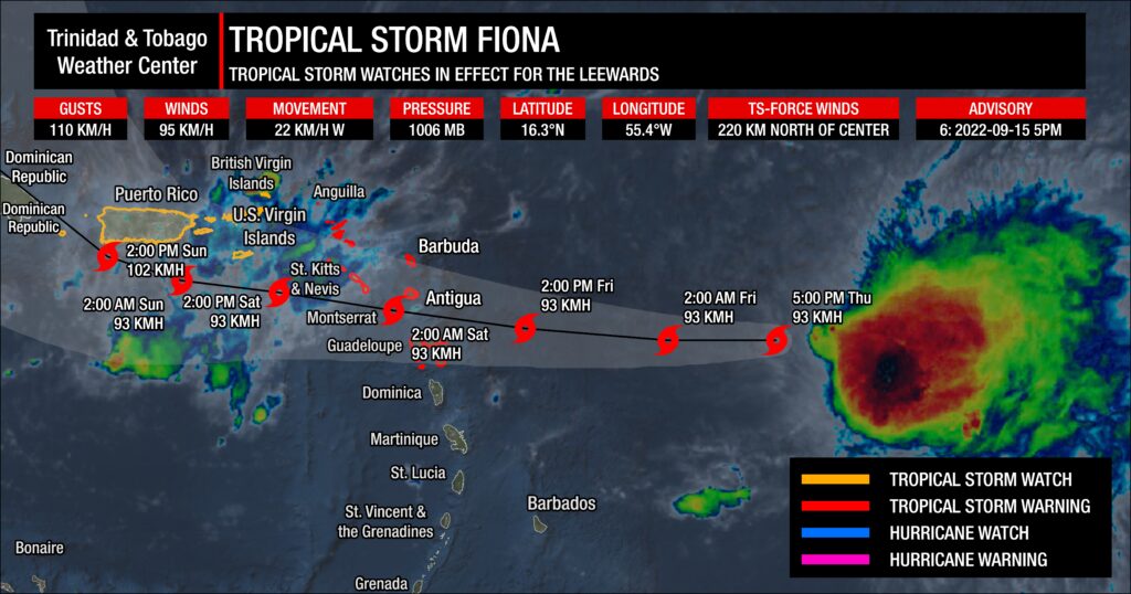
At 5:00 PM AST, the center of Tropical Storm Fiona was located near latitude 16.3°N and longitude 55.4°W. Fiona is moving toward the west near 22 KM/H.
Fiona remains an asymmetric storm with all its thunderstorms and strong winds currently located on the system’s east side. The lopsided structure is due to moderate to strong west-southwesterly vertical wind shear.
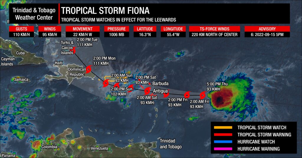
A low- to mid-level subtropical ridge over the central Atlantic should steer the system westward to west-northwestward during the next several days, taking the cyclone across the northern Leeward Islands by Friday night, near the Virgin Islands and Puerto Rico on Saturday, and near Hispaniola on Sunday and Monday. By Monday, the system is forecast to turn to the northwest.
By Monday, there is more divergence among the track models, with the stronger solutions indicating a sharper northwestward turn toward a weakness in the subtropical ridge. The weaker solutions keep Fiona on a westward or west-northwestward track, moving near or over Hispaniola. For now, the official track forecast from the National Hurricane Center is nudged southward and westward from the previous forecast, accounting for the adjusted initial position and the overall trend in the track guidance.
Data from an Air Force Reserve Hurricane Hunter aircraft indicate that maximum sustained winds are near 95 KM/H with higher gusts.
Given the current tilted and asymmetric structure, continued influences of shear, and some dry air, the NHC forecast maintains Fiona’s intensity over the next two to three days. By Monday (Day 3), Fiona is forecast to slow down, allowing for the circulation to become better organized even as shear remains unfavorable. As a result, some gradual strengthening is indicated in the NHC’s forecast by next week.
Tropical-storm-force winds extend outward up to 220 kilometers north of the center. The estimated minimum central pressure is 1006 millibars.
Tropical Storm Fiona’s Watches & Warnings
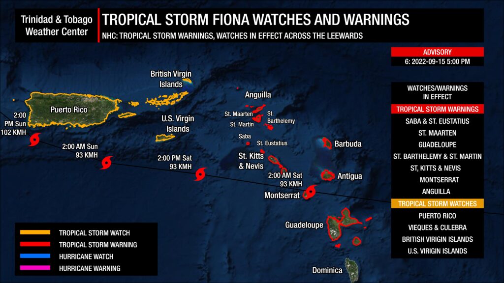
A Tropical Storm Warning is in effect for:
- Antigua, Barbuda, St. Kitts, Nevis, Montserrat, and Anguilla
- Saba and St. Eustatius
- St. Maarten
- Guadeloupe, St. Barthelemy, and St. Martin
A Tropical Storm Watch is in effect for:
- Puerto Rico, including Vieques and Culebra
- U.S. Virgin Islands
- The British Virgin Islands
A Tropical Storm Warning means that tropical storm conditions are expected somewhere within the warning area within 36 hours. A Tropical Storm Watch means that tropical storm conditions are possible within the watch area, generally within 48 hours.
Interests in Hispaniola should monitor the progress of this system. Additional watches or warnings will likely be required tonight or on Friday.
This system is of no direct threat to Trinidad and Tobago.
Hazards Affecting Land
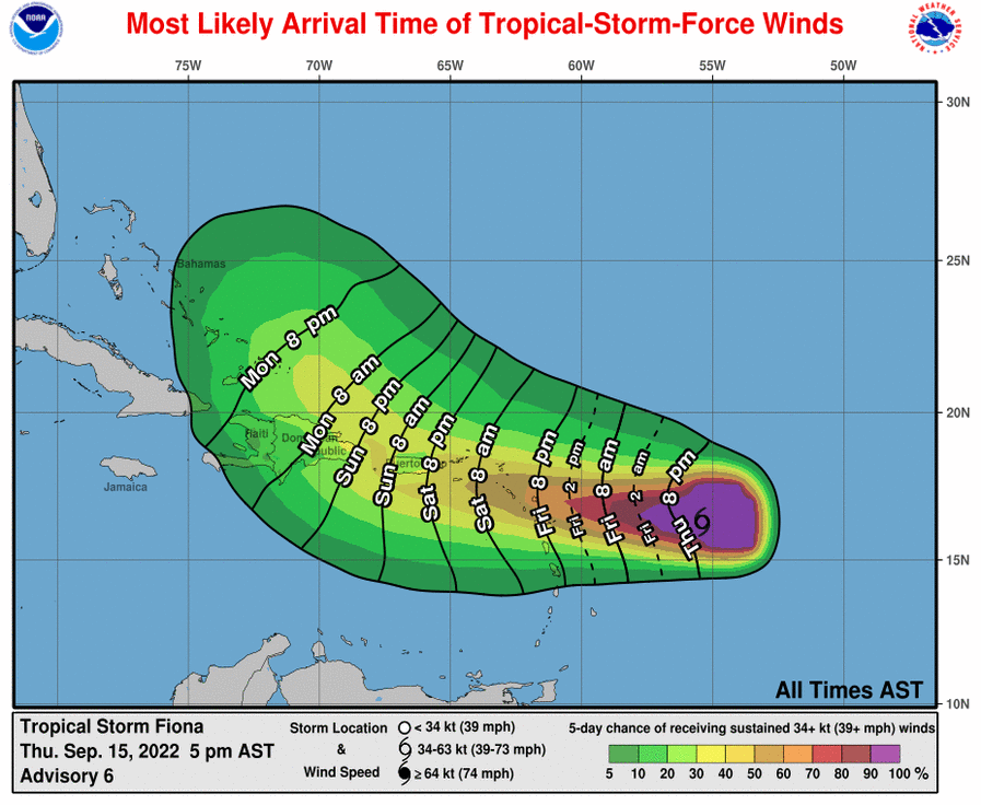
WIND: Tropical storm conditions are expected across portions of the northern Leeward Islands within the warning area beginning Friday evening. Tropical storm conditions are possible within the watch area across the Virgin Islands on Saturday and reaching Puerto Rico late Saturday or Saturday night.
RAINFALL: Fiona is expected to produce the following rainfall totals:
- Northern Leeward Islands, the British and U.S. Virgin Islands, and Puerto Rico: 4 to 6 inches
- Isolated maximum totals of 10 inches across eastern Puerto Rico.
- Eastern Hispaniola: 4 to 8 inches with isolated maximum totals of 12 inches.
Flash, urban, and stream flooding will be possible. Rapid rises on rivers are also possible in Puerto Rico, with mudslides possible in elevated areas. Considerable flood impacts are possible across eastern portions of Puerto Rico.
STORM SURGE: Localized coastal flooding will be possible along the coasts of the U.S. Virgin Islands and Puerto Rico in areas of onshore winds Saturday into Sunday.
SURF AND SWELLS: Swells generated by Fiona are beginning to affect the Leeward Islands and will spread westward to the Virgin Islands and Puerto Rico on Friday and Saturday. These swells could cause life-threatening surf and rip current conditions.
WATERSPOUTS: There is a low chance of waterspouts associated with heavy showers and thunderstorms that develop. If a funnel cloud touches down on a body of water, it becomes a waterspout; if it touches down on land, it becomes a tornado.
How Will Fiona’s Proximity Will Influence T&T’s Weather?
Not much has changed from our last update as Fiona is still forecast to reduce winds and cause a change in wind direction across the Windwards.
As with all tropical cyclones passing safely north of the Windwards, the high-pressure ridge pattern typically in place across the region, producing winds from generally the east, will be eroded. This will result in light to near calm and variable winds across Trinidad, Tobago, and other islands across the Windwards leading to very high daytime maximum high temperatures and uncomfortably warm nights.
While similar activity is forecast across the other islands, specifically for Trinidad and Tobago, by the afternoon on Friday through the weekend, due to sea breeze convergence, daytime heating, and orographic effects, localized showers and the odd thunderstorms are possible, initially favoring western coastal areas but spreading across mainly Trinidad.
By Friday, a surface to low-level trough induced by Fiona will be present across Trinidad and Tobago and the remainder of the Windwards. This trough, an increase in atmospheric moisture and convergence, and a change in the wind direction from predominantly the south to the southeast will marginally increase rainfall chances into the weekend. With a southeasterly or southerly wind direction, late afternoon to nighttime thunderstorms that develop along coastal Venezuela may approach southern Trinidad and into the Gulf of Paria. Still, strong northeasterly wind shear will limit both strength and coverage of thunderstorms from spreading across the country.
This trough is forecast to remain on Saturday and weaken into Sunday, while a trailing area of convergence will maintain unsettled weather and cloudy conditions across the region. However, a caveat will prevent widespread rains across Trinidad, Tobago, and the remainder of the Windwards – dry air at the mid-levels of the atmosphere.
Presently, very dry air exists at the mid to upper level of the atmosphere, while moisture is abundant at low levels of the atmosphere. These conditions will hold into Friday, with moisture increasing through the atmosphere on Saturday and Sunday.
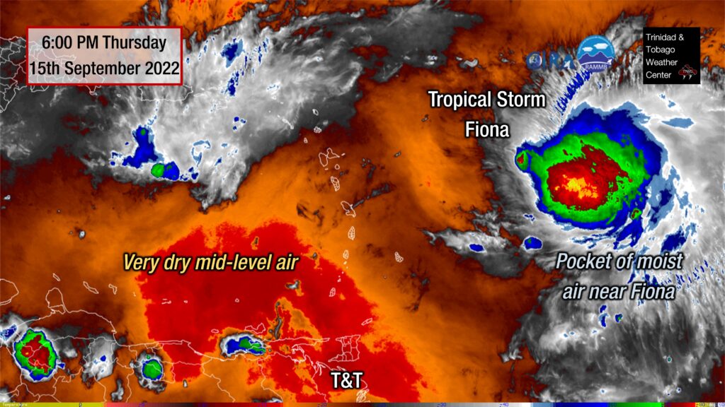
While moisture increased over the weekend, which will allow for increased cloudy periods, moderate to strong wind shear between 20 and 40 knots from the northeast will prevent deep and persistent convection (showers, thunderstorms) across Trinidad and Tobago.
Ultimately, mostly sunny skies and high temperatures are forecast through Friday, with isolated and slow-moving thunderstorms, mainly across Trinidad and, to a lesser extent, Tobago, producing localized inclement weather over the weekend. We’ll be looking out for highly localized gusty winds, localized to sporadic reports of street/flash flooding, and frequent cloud-to-ground lightning if isolated strong thunderstorms develop mainly on Saturday and possibly on Sunday afternoon.


