


The National Hurricane Center (NHC) is monitoring Tropical Wave 39 for development over the next several days as it approaches our area. It is forecast to move across the Windward Islands Wednesday into Thursday. Trinidad and Tobago continues to be influenced by Hurricane Fiona to the north and west of the region, as well as an approaching tropical wave (Tropical Wave 38) with periods of showers and isolated thunderstorms.
What you need to know
— What is it: A tropical wave (also called a tropical disturbance) producing disorganized showers and thunderstorms. It is not a tropical depression or tropical storm, but it is being monitored for development by the NHC for tropical cyclone formation after entering the Caribbean Sea.
— Who will be affected: Rainfall associated with this tropical wave is forecast to affect the southern and central Windward Islands and the French Antilles through Friday. Namely, islands from Trinidad and Tobago to Dominica, including Barbados, are in the path of this tropical wave’s heaviest rainfall, with the strongest winds forecast to affect islands between Grenada and Dominica, remaining north of T&T.
— What can you expect: The main hazards associated with this system will be periodic showers and thunderstorms with isolated heavy to violent rainfall rates. Street/flash flooding may accompany these higher rainfall rates. Gusty winds up to and over 45 KM/H are possible for T&T, with gusts in excess of 65 KM/H possible for islands north of T&T, accompanying heavier showers and thunderstorms. Lightning will accompany thunderstorms. Landslides and rockfalls are possible in elevated areas.
— Alerts/Watches/Warnings: There are no alerts, watches, or warnings in effect for Trinidad and Tobago from the Trinidad and Tobago Meteorological Service at this time. The Barbados Meteorological Service issued a statement on the disturbance, advising that marine and rainfall-based watches/warnings may be issued from Tuesday, September 20th, 2022, where no alerts, watches, or warnings are in effect at this time. Similarly, St. Vincent and the Grenadines (SVG) Meteorological Services issued a statement advising moderate to heavy showers, thunderstorms, and gusty winds across the country by mid-Thursday afternoon. A weather advisory is in effect for SVG due to the low risk of flash flooding. There are no tropical storm or hurricane watches or warnings in effect for any country within the Lesser Antilles at this time.
The latest from the NHC
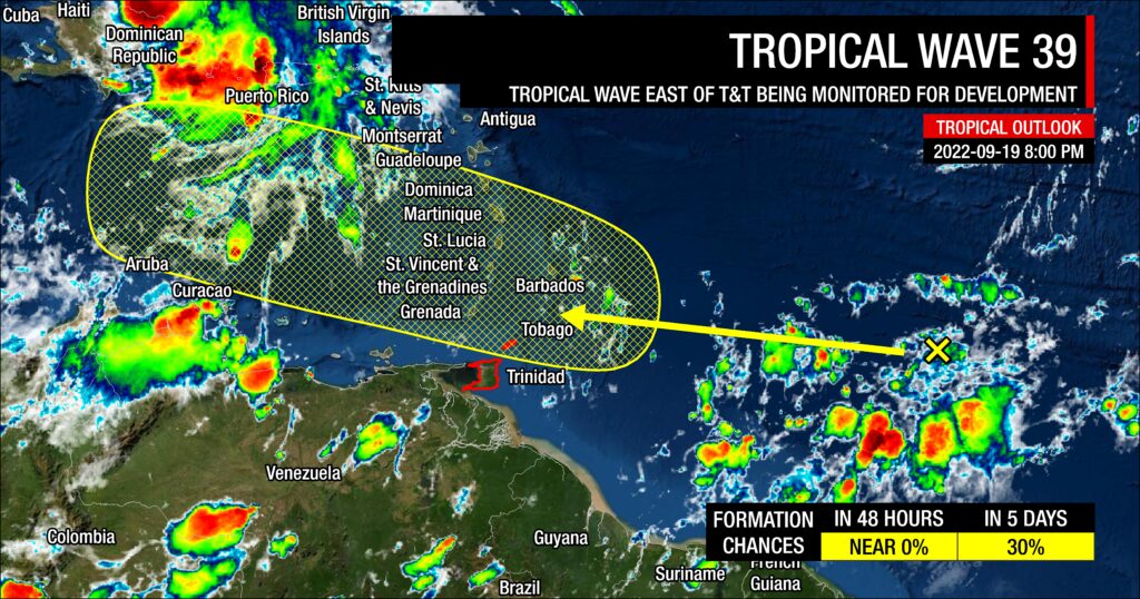
As of their 8:00 PM Tropical Weather Outlook, the NHC says, “A tropical wave located several hundred miles east of the Windward Islands is producing an area of disorganized showers and thunderstorms. Some gradual development of this system is possible during the next several days while the system approaches the Windward Islands toward the end of the week and moves over the eastern Caribbean sea over the weekend.”
They give the disturbance a low chance of development over the next 48 hours and five days at near 0% and 30%, respectively. Five-day chances increased from 20% at 2:00 PM.
The disturbance is located approximately less than 1,300 kilometers east of Trinidad and Tobago, though scattered showers and thunderstorms are widely scattered between T&T and this tropical wave.
Who will be affected?
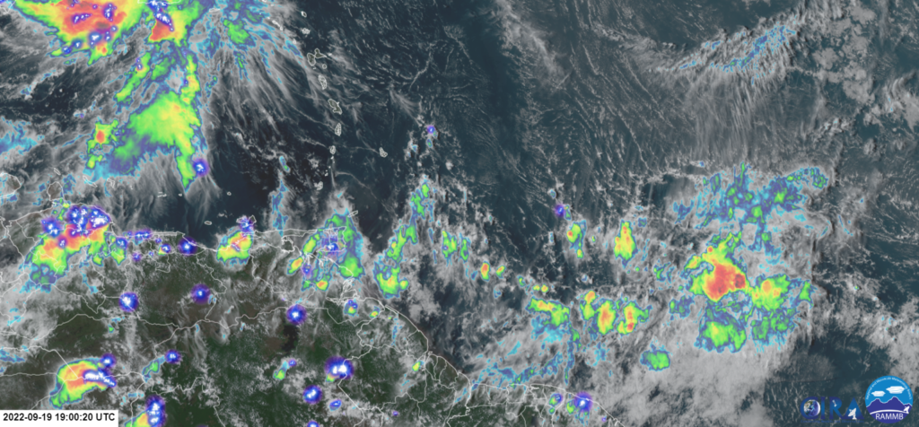
In the short term, low-level convergence trailing Hurricane Fiona is forecast to continue aiding the development of showers and isolated thunderstorms. Then, Tropical Wave 38 is forecast to track across the islands on Tuesday, bringing more showers and isolated thunderstorms.
The European ECMWF, United Kingdom’s UKMO, and French ARPEGE bring an area of weak low pressure (1009-1010 millibars) across or near Trinidad and Tobago on Wednesday morning, while the American GFS model is slower, brings a stronger area of low pressure between Tobago and Barbados early Thursday morning. In all model outputs on Monday afternoon, the heaviest rains and strongest winds remain north and east of the low pressure, generally sparing T&T from the worst of winds from this disturbance but not necessarily rainfall.
Update: The 18Z GFS model, as well as the 18Z Hurricane Weather Research and Forecasting Model (HWRF), which is considered the operational backbone for hurricane track and intensity forecasts by the National Hurricane Center, both show substantial development of this system before reaching the Windwards. The GFS brings a well-organized low-pressure system closer to Tobago, with HWRF showing a similar solution. If these materialize, potentially heavy rainfall and strong winds will likely affect Tobago and possibly northern Trinidad, but these model outputs are currently the outlier.
All models show conditions becoming much more favorable for development as the disturbance moves into the central and western Caribbean Sea.
As this tropical disturbance approaches the Windwards on Wednesday, wind shear is forecast to be light to moderate, up to 20 knots. Mid-level moisture is forecast to be moderately moist with relative humidity values between 55% and 70%, increasing above 70% by Thursday. Precipitable water values are forecast to be above 2 inches (50 millimeters) from Wednesday through Tuesday. These factors, combined with a favorable upper-level environment due to the favorably positioned upper-level trough east of the region, will support scattered to widespread showers and periods of rain with isolated showers and thunderstorms producing heavy/violent rainfall rates.
Islands between Trinidad and Tobago, extending northwards to Dominica, including Barbados, should all be monitoring this system and closely monitoring the meteorological alerts, watches, and warnings from your local meteorological offices.
Tropical Wave 39’s hazards
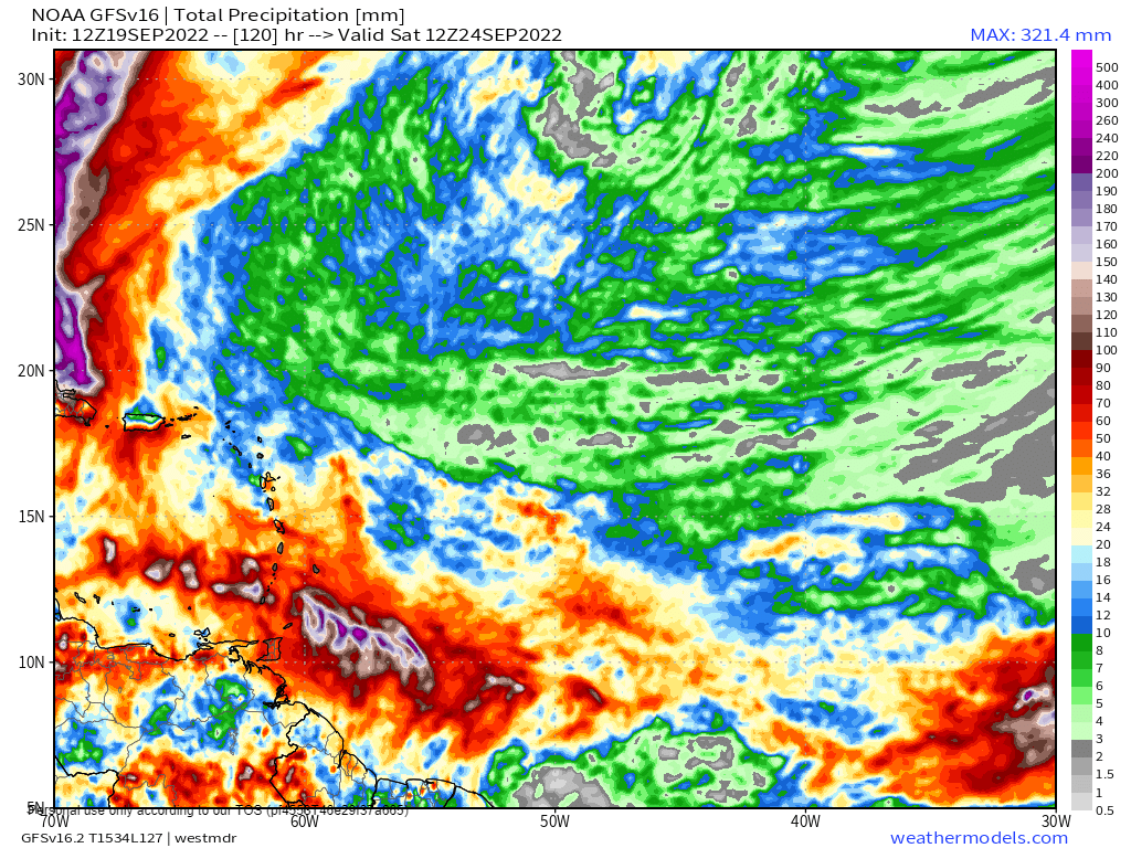
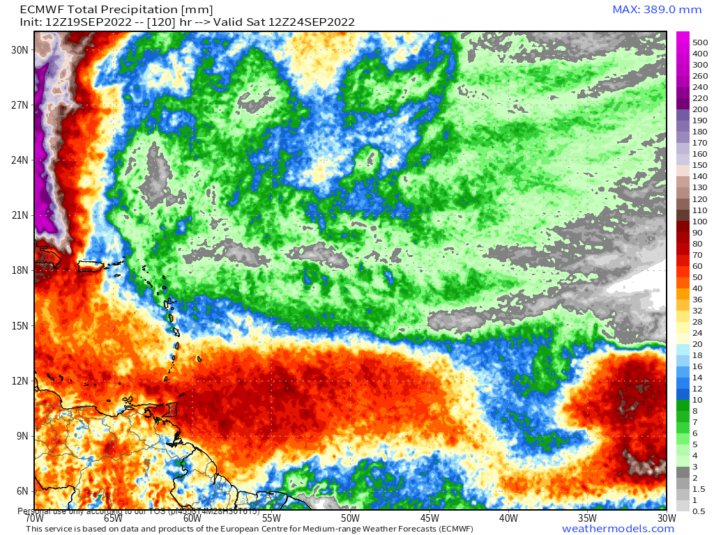
This tropical disturbance is primarily a rainfall threat to the eastern Caribbean. Forecast models indicate rainfall accumulations between 50 and 100 millimeters are forecast from Trinidad and Tobago to Martinique, including Barbados, with isolated totals reaching 150 millimeters over the next five days. In highly localized areas, overall rainfall accumulations could exceed 150 millimeters. These higher totals are possible on islands’ Windward (or Atlantic-facing) slopes. Street/flash flooding is likely in heavier showers/thunderstorms or areas that receive prolonged rainfall.
For Trinidad and Tobago, localized climatic effects will also contribute to shower/thunderstorm activity. Rainfall accumulations between 50-75 millimeters are forecast across both islands, with isolated totals up to 150 millimeters, favoring Tobago and northern and eastern Trinidad, through Saturday. Similarly, street/flash flooding is possible through Saturday, with chances for riverine flooding low at this time.
Elevated winds associated with this tropical disturbance are forecast to mainly affect islands north of Tobago, between Grenada to Dominica, with sustained winds generally up to 35 KM/H and gusts up to 65 KM/H. Peak sustained winds can exceed 35 KM/H, with gusts exceeding 65 KM/H, across St. Lucia, St. Vincent and the Grenadines, Grenada and its dependencies, and Barbados. Lightning will accompany thunderstorms. Landslides and rockfalls are possible in elevated areas.
As a fairly light and variable wind regime is in place across Trinidad and Tobago through Wednesday, funnel cloud development is possible. If a funnel cloud touches down on a body of water, it becomes a waterspout; if it touches down on land, it becomes a tornado.
What should you do?
No tropical storm or hurricane is bearing down on Trinidad, Tobago, or the remainder of the Lesser Antilles at this time.
As an individual, there are a couple of things you can do as we head through the peak of the 2022 Atlantic Hurricane Season, though there are no organized tropical cyclones on our horizon:
- Stock your emergency kit
- Clean your surroundings and gutterings
- Secure light or loose objects outdoors
- If your roof is unsecured, purchase and install hurricane straps
- Clear larger trees near your home
- Ensure you have batteries and battery packs for your flashlights, radios, and mobile devices
- Ensure you have sufficient gas for gas-powered stoves and vehicles
- Ensure you have adequate dry foods and water to rally through an extended power outage (generally, the rule of thumb is 72 hours).
- Stock up on candles and mosquito repellant.
- Ensure you have alternative means of communication (like a battery-powered radio) if the internet or television goes down.
- Have a trusted source of information for the latest news before, during, and after a storm.
Elsewhere in the Atlantic
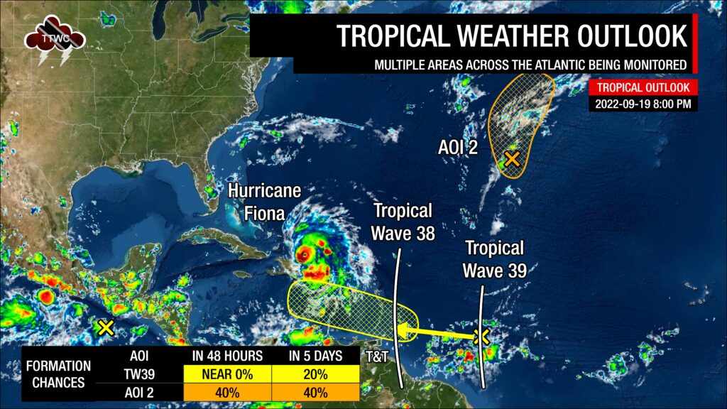
The NHC is also monitoring another tropical disturbance – an area of low pressure over the Central Subtropical Atlantic for tropical cyclone development. The system has a low chance of development over the next 48 hours and five days, with a 40% chance of development. According to the NHC in their 8:00 PM Tropical Weather Outlook, “Some slow development, however, is possible during the next couple of days before environmental conditions become less conducive later this week. The system should generally move northward or northeastward while remaining over the open central subtropical Atlantic.”
Advisories are also being issued on Hurricane Fiona, which continues to bring catastrophic flooding to Puerto Rico and the Dominican Republic. Fiona is forecast to become a major hurricane by Wednesday.


