Tropical Storm Philippe’s center relocated approximately 130 kilometers east-southeast of Barbuda on Monday morning, prompting the Antigua and Barbuda Meteorological Service to issue a Tropical Storm Warning for Barbuda as the risk for tropical-storm-force winds has increased.
Meanwhile, feeder band activity continues to affect the entire Lesser Antilles island chain, from as south as Trinidad and Tobago, to as north as Anguilla, with the most intense activity generally remaining east of the region.
What you need to know
— What has happened: Tropical Storm Philippe has remained near the Lesser Antilles for the last several days, influencing the atmosphere across the region, leading to strong afternoon thunderstorms and hot temperatures in T&T. Feeder band activity has also affected the Lesser Antilles, and influencing prevailing low-level winds across T&T, leading to showers and thunderstorms developing and moving from the southwest/south to northeast/north.
— Where is it forecast to move: As Philippe moves slowly but erratically west-northwest, a northwestward to north-northwestward turn is expected later today and tonight before moving into the open North Atlantic Ocean. However, it is forecast to make a fairly close pass to Antigua and Barbuda, bringing the risk of tropical storm-force winds, gusts, and heavy rainfall.
— The Intensity: Forecast models and the National Hurricane Center indicate Philippe remains a tropical storm as it moves past Antigua and Barbuda and further strengthen as it moves into the North Atlantic Ocean later this week, with the potential to become a hurricane.
— The Impacts: For Barbuda, tropical-storm-force winds and gusts are expected, while for Antigua, tropical-storm-force winds are possible with heavy rainfall, strong wind gusts, and agitated seas likely for both islands. For the remainder of the Lesser Antilles, including T&T, feeder band activity and enhanced convergence will support heavy showers and isolated intense thunderstorm activity that can produce gusty winds (>55 KM/H) capable of causing wind damage, heavy/violent rainfall rates triggering street/flash flooding, agitated seas, landslides, and frequent cloud-to-ground lightning.
— Latest from officials: Barbuda is under a Tropical Storm Warning. Antigua is under a Tropical Storm Watch. T&T’s Adverse Weather Alert (Yellow Level) has been discontinued, but thunderstorms continue. Yellow-level alerts for heavy rains and thunderstorms exist for Martinique and Guadeloupe, while an Orange-level Flash Flood Watch and Severe Thunderstorm Watch are in effect for Barbados.
The Latest
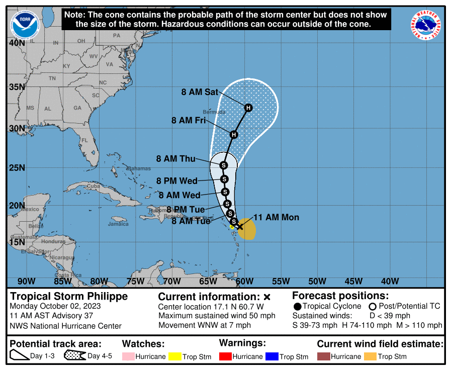
According to the National Hurricane Center, at 11:00 AM AST, the center of Tropical Storm Philippe was located by an Air Force Reserve Hurricane Hunter near latitude 17.1 North, longitude 60.7 West. Philippe is moving toward the west-northwest near 11 KM/H, and a northwestward motion is expected to resume later today through early Tuesday.
A turn toward the north-northwest is forecast to occur by late Tuesday, followed by a northward motion on Wednesday. On the forecast track, the center of Philippe is expected to pass near or just northeast of the northern Leeward Islands tonight. Note that the strongest winds and heavy rains will likely occur after the center passes.
Maximum sustained winds remain near 85 KM/H with higher gusts. Little change in strength is forecast during the next day or so, but Philippe could begin to intensify more significantly around the middle of the week. Tropical-storm-force winds extend outward up to 280 kilometers from the center, mainly toward the south and east. The estimated minimum central pressure is 1000 millibars based on dropsonde data.
A Tropical Storm Warning is in effect for Barbuda, while a Tropical Storm Watch is in effect for Antigua. A Tropical Storm Warning means that tropical storm conditions are expected somewhere within the warning area, in this case, within 12 hours. A Tropical Storm Watch means that tropical storm conditions are possible within the watch area, in this case, within 12 hours. Interests elsewhere in the northern Leeward Islands should monitor the progress of this system, according to the National Hurricane Center.
Philippe is forecast to produce the following rainfall amounts through Tuesday:
- Barbuda and Antigua: 4 to 6 inches (100 to 150 millimeters)
- Rest of Leeward Islands: 2 to 4 inches (50 to 100 millimeters)
This rainfall may result in isolated to scattered flash flooding.
WIND: Tropical storm conditions are expected in the warning area beginning this evening and are possible in the watch area beginning this evening.
SURF: Swells generated by Philippe will affect portions of the Atlantic coasts of the northern Leeward Islands, the Virgin Islands, and Puerto Rico through midweek. These swells are likely to cause life-threatening surf and rip current conditions.