


A well-defined tropical wave – Tropical Wave 52 – has been designated as Invest 94L and has a high chance of tropical cyclone formation over the next 48 hours and seven days, respectively. Forecast models show the development of this system over the next several days, but increasing shear is forecast to keep most of the strong winds and heavy rains east of the Lesser Antilles and well north of T&T and the Windwards based on model runs on Wednesday afternoon.
Based on the projected path, this system is forecast to spare Trinidad and Tobago and the Windwards from significant winds and rains but will bring a weakened wind regime, marginally increased temperatures, elevated rain chances, and agitated seas to the area.
What you need to know
— What has happened: A robust tropical wave, designated as Invest 94L, is being monitored for tropical cyclone formation in the Main Development Region of the Tropical Atlantic, approximately 1,100 kilometers east of Trinidad and Tobago.
— Where is it forecast to move: Forecast models have consistently shown Invest 94L and the eventual tropical cyclone remaining north of Trinidad and Tobago and the southern Windwards, based on model runs over the last few days. However, the latest models show the center of the system moving near or even across the northern Windwards and Leewards from Friday morning into Saturday.
— The Intensity & Impacts: Forecast models indicate this disturbance will likely be a tropical storm as it moves near or even through the central/northern Lesser Antilles. While feeder band activity can’t be ruled out at this time for the Windwards, for islands south of the center of circulation, no significant rainfall or winds are forecast. Isolated daytime showers and thunderstorms, favoring the western halves of the islands, are possible from Friday for the southern Windwards, while cloudy skies, windy conditions with periods of showers and thunderstorms, and agitated seas are likely for the northern half of the island chain.
— Latest from officials: Across the island chain, there are no alerts, watches, or warnings. However, several meteorological offices, like Antigua and Barbuda, Barbados, and Trinidad and Tobago, have issued statements on the system.
The latest

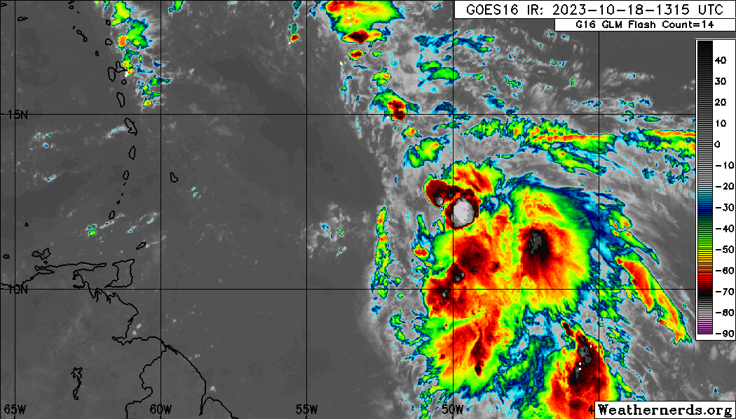
At 2:00 PM Wednesday, October 18th, 2023, the approximate center of Invest 94L’s compact low-pressure area was located along 50.5°W, placing it approximately 1,100 kilometers east-northeast of Trinidad and Tobago.
According to the National Hurricane Center’s (NHC) 2:00 PM Tropical Weather Outlook, “Recent visible satellite images indicate that the circulation associated with an area of low pressure located about 700 miles east of the Windward Islands is gradually becoming better defined. In addition, the associated shower and thunderstorm activity is becoming more organized, and satellite-derived wind data indicated that the system is already producing winds to tropical storm force. Continued development is anticipated, and a tropical storm is expected to form later today or tonight while moving westward or west-northwestward toward the Lesser Antilles.”
The NHC adds, “Interests in the Lesser Antilles should continue to monitor the progress of the disturbance. Advisories may be initiated on this system as early as later this afternoon and could include the issuance of watches for some of the islands. Regardless of development, this system has the potential to bring gusty winds, heavy rainfall, and flash flooding to portions of the Lesser Antilles beginning on Friday.”
This area of disturbed weather is producing a cluster of cloudiness with scattered showers and thunderstorms. It is located in a pocket of favorable upper-level divergence and low-level convergence. The area of most intense convection is located in an area with low to moderate vertical wind shear, but to the east, very strong shear has kept thunderstorms at bay. Sea surface temperatures are between 29°C and 30°C with anomalously high atmospheric moisture.
What is an Invest?
In Meteorology, an INVEST (short for an investigative area, also called an area of interest) is a designated area of disturbed weather monitored for potential tropical cyclone formation.
In the Atlantic Basin, these INVESTs are designated by the United States National Hurricane Center, numbered from 90 to 99, followed by the suffix L. These suffixes change for each basin, with “E” and “C” in the Eastern and Central Pacific basins (respectively), or “W” in the Western Pacific basin. Numbers are rotated within the season and are re-used as necessary (the subsequent INVEST after 99 would be numbered 90).
According to the National Hurricane Center, by designating a tropical weather system as an INVEST, the collection of specialized data sets and computer model guidance on the area of interest can begin. This collection and processing of data are shown on several government and academic websites for analysis.
The designation of a system as an INVEST does not necessarily correspond to any particular likelihood of the development of the system into a tropical cyclone.
Where is it going?

Forecast models show Invest 94L being steered west-northwest over the next several days as it ridges the periphery of a large subtropical ridge anchored in the North Atlantic Ocean, taking the system near or even across the northernmost Windward islands and Leewards.
Over the last 36 or so hours, Invest 94L has maintained a generally west-northwestward path, but once this system consolidates, as with most tropical cyclones east of the Lesser Antilles, it begins to move west-northwest and northwestward as it strengthens.
As it stands on Wednesday, Invest 94L and the eventual tropical cyclone from this disturbance is no threat to Trinidad and Tobago. While forecast models keep this low-pressure system north of the southern Windwards, those north of Barbados and St. Vincent and the Grenadines, towards the Leewards should pay close attention to forecasts over the next 48 hours as it nears the area.
How strong could it get?
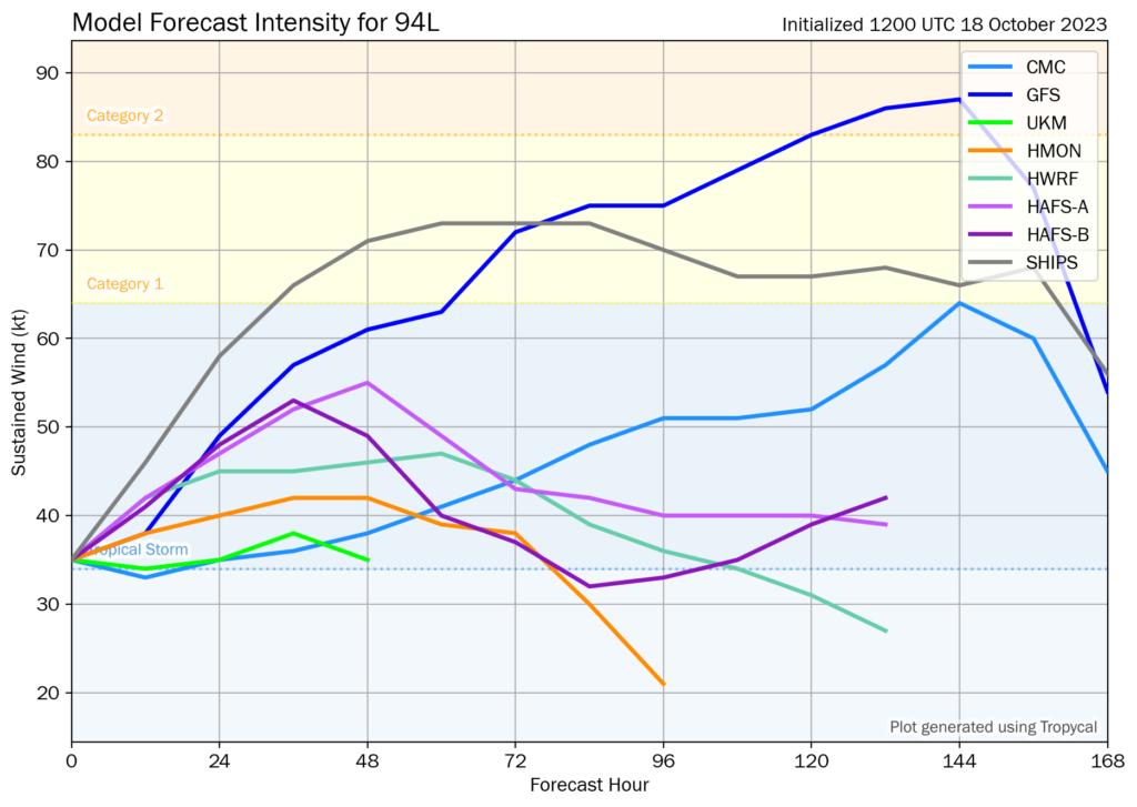
Based on the current forecast tracks, models move Invest 94L through a favorable environment. With an upper-level high above the eventual tropical cyclone, with subtropical jet streams allowing for the storm to be ventilated (outflow leading to favorable upper-level condition, high sea-surface temperatures, and a relatively moist environment, leading forecast models and their ensembles show Invest 94L becoming a tropical storm as early as this (Wednesday) evening the limiting factors will be moderate to strong wind shear from the west, which will keep most of the clouds, rains, and intense winds east of the islands.
According to the National Hurricane Center’s 2022 verification report, the consensus models IVCN and HCCA were the best aids overall, while the HWFL was the best individual model. For Invest 94L, these models have continuously shown a tropical storm through the next 72 to 96 hours (3 to 4 days).
What does this mean for the Lesser Antilles?
For the northern half of the Lesser Antilles, tropical cyclone preparedness plans should be reviewed, as some islands may be placed under a tropical storm watch as early as later today, Wednesday afternoon. There is an increasing risk of heavy rainfall that will produce floods, landslides, and mudslides, as well as strong winds and gusts that can produce wind damage and agitated seas.
For the southern half of the Lesser Antilles, mainly from Barbados and St. Vincent and the Grenadines southward, the main hazards from Thursday into the weekend will be localized, heat-driven, heavy showers/thunderstorms along western and northern areas of islands, and potentially hazardous seas, mainly for the northern islands. Stronger southerly winds may also lead to isolated thunderstorms being enhanced by topography, and with near-calm to light winds mainly on Thursday and Friday and clockwise turning winds through the atmosphere, the potential for funnel clouds will also exist.
Wind

Based on the latest guidance, tropical-storm-force wind gusts and sustained winds (above 34 knots, 39 MPH, 63 KM/H) are forecast to primarily affect the northernmost Leewards, mainly north of Guadeloupe and east of the U.S. Virgin Islands are forecast to experience wind gusts in heavy showers/thunderstorms up to 35 MPH or 56 KM/H. However, this is dependent on how close the core of the eventual system moves to the Leewards. It should be noted that with systems that have not yet formed, there is a larger-than-usual uncertainty in both the track and intensity forecast.
For the central Lesser Antilles, a low-level to surface trough extending southwestward from the eventual low-pressure system will create slack to near-calm winds, leading to hot daytime temperatures and isolated late-morning through afternoon showers/thunderstorms along western and hilly areas.
For the southern Lesser Antilles, including T&T, the pressure gradient between the low-pressure system north of the Lesser Antilles and a high-pressure system over northern South America will lead to strong low-level southeasterly winds across the area from Friday (the peak) through Saturday, which can make it to the surface in showers or thunderstorms. Wind gusts exceeding 35 KM/H are likely during this period.
Rainfall

The highest rainfall accumulations are forecast to occur across the northernmost Leewards and the northern half of the Lesser Antilles, with rainfall totals through Monday, October 23rd, 2023, ranging between 50 and 100 millimeters (2-4 inches) with isolated totals up to 150 millimeters (6 inches) based on the current forecast track.
For the southern half of the Lesser Antilles, rainfall totals are forecast to be between 0 to 25 millimeters (0-1 inches), with isolated totals of up to 75 millimeters in afternoon thunderstorm activity.
Seas and Storm Surge
There is still substantial uncertainty on where the strongest winds from Invest 94L are forecast to track, which highly influences the sea’s forecast. Based on the latest model guidance, waves in open waters are forecast to be near 3.0 meters (9 feet) at east and north-facing coastlines from Guadeloupe to Anguilla. From Dominica to Barbados, inclusive of St. Vincent and the Grenadines, open water waves can reach as high as 2.5 meters (8 feet), mainly Thursday night into Friday, but this is dependent on a more northwestward path, otherwise for much of the Lesser Antilles, larger waves are possible for all islands. For T&T, seas are forecast to remain moderate, with open waters waves occasionally up to 2.5 meters from Friday morning through Saturday.
Again, this is based on current track and intensity guidance, which can change in the coming days.
For Trinidad and Tobago
Latest Forecast

Forecast: Isolated Showers, Thunderstorms Ahead of Significant Saharan Dust Surge
Trinidad and Tobago is NOT under any tropical storm or hurricane threat, watch, or warning at this time.
Pay close attention to official forecasts in the coming hours and days from your respective authorities. For Trinidad and Tobago, official forecasts and early warnings come from the Trinidad and Tobago Meteorological Service.


