


Four tropical waves between Trinidad and Tobago and the African Coast are all forecast to move across the region in the coming seven days, with the closest wave moving across the country overnight tonight. As we head into June, tropical waves are forecast to become more frequent, moving across T&T every two to three days.
Meanwhile, in the Gulf of Mexico west of Florida, the National Hurricane Center is monitoring an area of low pressure for tropical cyclone development, but chances are low as it meanders in the eastern Gulf over the weekend, with atmospheric conditions becoming increasingly unfavorable as the system drifts southeastward.
What you need to know
— Tropical Wave 05: The axis of this wave moved across Trinidad and Tobago on Monday into Tuesday, producing scattered showers and thunderstorms. This wave has since dissipated well west of T&T.
— Tropical Wave 06: This axis of this tropical wave is set to move across Trinidad and Tobago on Wednesday night, with widely scattered showers and isolated thunderstorms, as well as a surge of winds trailing the wave axis. Higher winds are forecast to remain north of T&T.
— Tropical Wave 07: The axis of this tropical wave is located along 53W, moving west at 10 to 15 knots (18-27 KM/H). This wave, though dropped from the National Hurricane Center’s surface analysis, is forecast to move across T&T and the Windwards on Thursday, June 1st, 2023.
— Tropical Wave 08: The axis of this tropical wave is located along 43W, moving west at 10 to 15 knots (18-27 KM/H). This wave is forecast to move across T&T and the Windwards on Friday, June 2nd, 2023, into Saturday, June 3rd, 2023.
— Tropical Wave 09: The axis of this tropical wave is located along 13W, moving west at 10 to 15 knots (18-27 KM/H). This wave is forecast to arrive across the southern Windward islands by late Tuesday, June 6th, 2023, into Wednesday, June 7th, 2023.
— Invest 91L: The NHC is monitoring a low-pressure system off the coast of Florida in the southeastern United States in the Gulf of Mexico. The system is producing disorganized showers and thunderstorms, forecast to bring heavy rainfall and flooding to Florida into the weekend.
— Hazards: Showers, periods of rain, and thunderstorms are all forecast across Trinidad and Tobago over the next five to seven days. While localized street/flash flooding, landslides, and gusty winds are likely, the total rainfall accumulations are not forecast to be as extreme as we’ve seen in the past with multi-day rainfall events, likely due to the concentrations of Saharan Dust that are forecast to be present. Still, as we head into next week, river levels are set to become increasingly elevated, with smaller streams becoming overwhelmed. See the forecast for more information.
— Development Concerns: Outside of Invest 91L in the Gulf of Mexico, elsewhere across the Atlantic, tropical cyclone development is not expected, according to the National Hurricane Center.
Tropical Wave 06
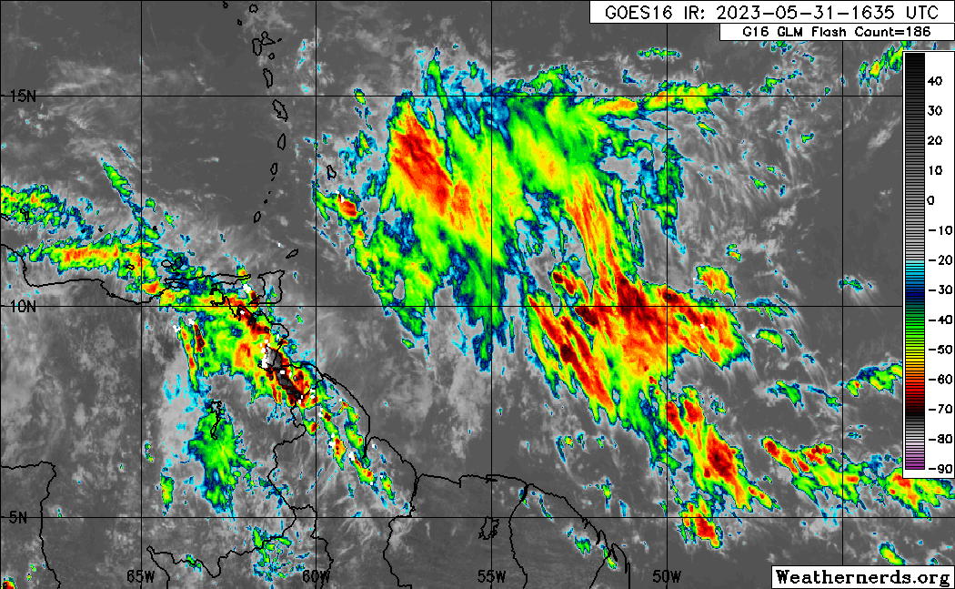
The sixth tropical wave for 2023, analyzed as of 4:00 PM May 31st, 2023, is along 58/59W and south of 14N, moving west at 10 to 15 knots (18 to 27 KM/H). While the axis of the wave is still east of T&T, showers and thunderstorms ahead of the wave axis affected T&T on Wednesday, with much of the stronger convection remaining north and east of the country.
Additionally, a surge of strong winds (up to 60 KM/H) follows the wave axis, but based on satellite-derived wind data, these stronger winds remain north of Tobago.

Across the wave axis, total precipitable water (a measure of atmospheric moisture) values are near 2.16 inches, but with relative humidity between 300mb to 850mb, around 75%, indicative of a very moist atmosphere.
Upper-level conditions have been very favorable east of Trinidad and Tobago and are becoming increasingly favorable over the southern Windward Islands on Wednesday evening, supporting increased cloudiness and pockets of stronger convection (showers/thunderstorms). Low-level conditions are marginally favorable but still supportive of isolated showers and thunderstorm activity. Wind shear is strong, up to 45 knots from the northwest, which is keeping much of the heavier showers and thunderstorms east of the country.
Specifically for T&T, as this tropical wave and associated activity move west, wind shear across Trinidad and Tobago is forecast to remain strong, with mid to upper-level conditions becoming increasingly unfavorable due to sinking air, inhibiting widespread and persisting showers and thunderstorms. As a result, while there is the potential for increased showers/thunderstorms, overall, stronger showers, thunderstorms, and heavy rainfall are forecast to remain offshore eastern Trinidad and Tobago. Additional details can be found in the weather forecast.
Tropical Wave 07
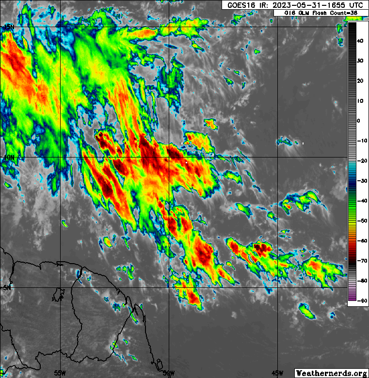
The axis of Tropical Wave 07 along 53W on Wednesday, May 31st, 2023, with scattered moderate to isolated strong convection between 8N and 12N, between 55W and 45W, east of Trinidad and Tobago. (Weathernerds.org)
The National Hurricane Center has dropped this tropical wave from its surface analysis. However, while the wave axis may no longer be clearly defined to be classified as a tropical wave, the moisture surge and active convection still exist as it is currently in a highly favorable upper-level and low-level environment.
Based on satellite and satellite-derived data, the seventh tropical wave for 2023 is located along 52/53W, south of 13N, moving west at 10 to 15 knots (18-27 KM/H). Scattered showers, isolated thunderstorms, and widespread cloudiness exist between 45W and 55W south of 15N.
Based on forecast models, this wave is forecast to eventually move across the Windwards on Thursday, June 1st, 2023. However, low-level conditions are forecast to be fairly unfavorable.
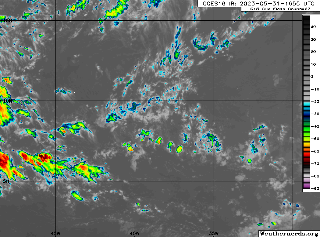
Tropical Wave 08

The eighth tropical wave for 2023 is located along 43W, south of 14N, moving west at 10 to 15 knots (18 to 27 KM/H). Currently, scattered weak to moderate convection (showers and thunderstorms) are associated with this wave, mainly following the wave axis.
Forecast models also show this wave not being particularly intense as it moves across Trinidad and Tobago on Friday into Saturday. Still, showers and thunderstorms are possible during this period, though activity is likely to be suppressed by a surge of approaching Saharan Dust even though the overall atmosphere will be very moist, with subsiding air at the upper levels. Shear is also forecast to be moderate, up to 20 knots, during this period.
The highest chances for heavy rainfall exist on Friday morning and Saturday morning, where the overall atmospheric state will support heavy rainfall rates.
Tropical Wave 09
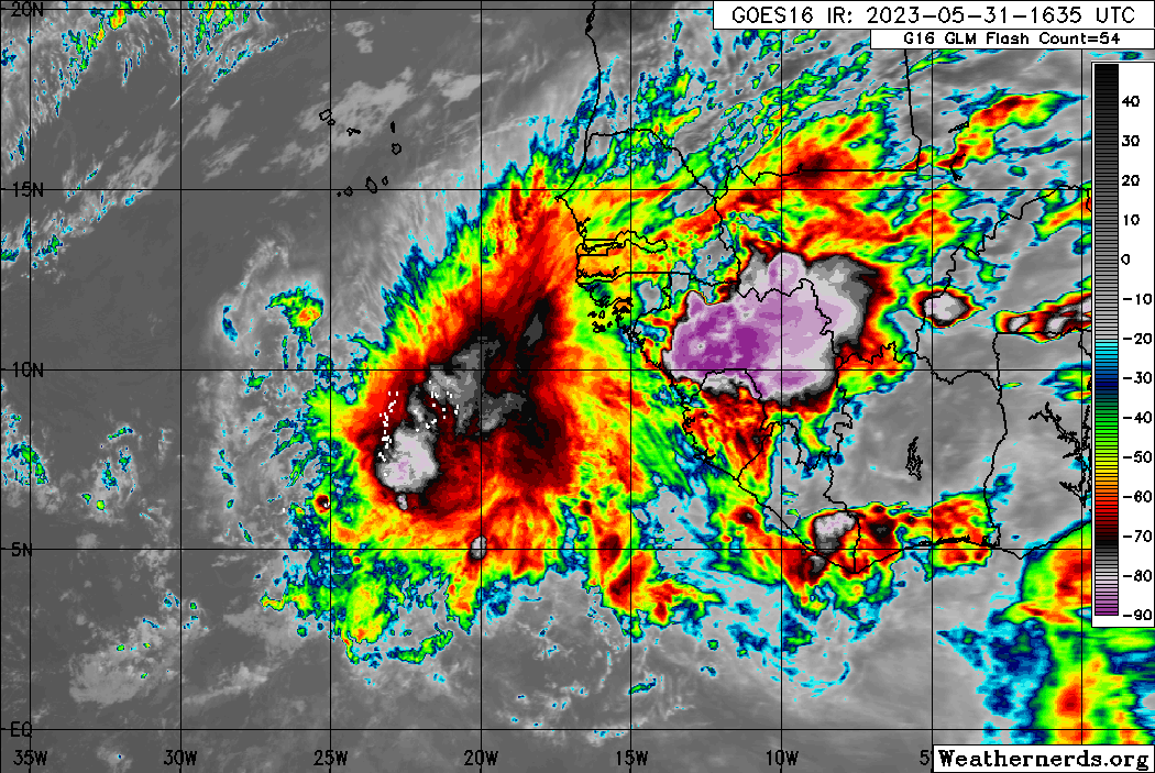
The ninth tropical wave for 2023 is leaving the African coast with significant convection both ahead and trailing the wave axis. As of 4:00 PM, the axis of this tropical wave is located along 13W, moving west at 10 to 15 knots (18 to 27 KM/H).
Trade winds are forecast to remain weak across the Atlantic over the next several days, leading to weaker steering currents for this tropical wave. As a result, this tropical wave is forecast to slow down as it moves across the Atlantic Ocean, with forecast models showing the wave and associated moisture plume reaching across the Windwards by June 6th into June 7th, in tandem with moderate to high concentrations of Saharan Dust present, which could weaken the wave.
While longer-range forecast models show a deep plume of moisture moving across much of the southern Windwards, rainfall totals are forecast to generally remain below one inch (25 millimeters). Ultimately, there is still abundant time to monitor this wave as it moves across the Atlantic, with eventual impacts still a week away.
Invest 91L
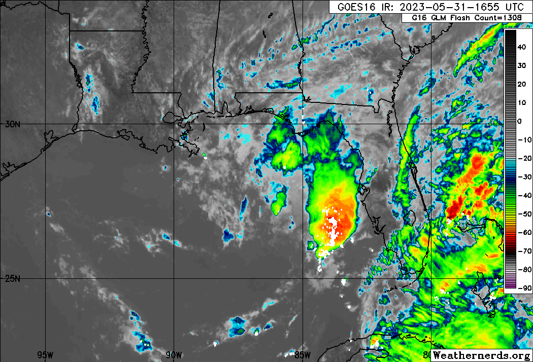
The National Hurricane Center (NHC) has been monitoring an area of disturbed weather south and west of Florida for the last several days, giving it a low (20%) chance of tropical cyclone formation over the next 48 hours and seven days as of 2:00 PM Wednesday, May 31st, 2023.
In their latest Tropical Weather Outlook, the NHC says, “An area of low pressure has formed over the northeastern Gulf of Mexico in association with disorganized showers and thunderstorms displaced to its northeast. Environmental conditions appear marginally favorable for some slow development over the next day or two as the system meanders over the northeastern Gulf of Mexico. However, by this weekend, environmental conditions are forecast to become unfavorable for additional development as the system drifts southeastward towards the Florida Peninsula. Regardless of development, the system could produce heavy rainfall and gusty winds over portions of the Florida Peninsula through this weekend.”
On Wednesday afternoon, the NHC designated this area of low pressure as Invest 91L. This designation is given to systems that warrant additional attention, with two aircraft reconnaissance flights carded for June 1st, 2023.
This system poses no threat to Trinidad, Tobago, and the remainder of the Eastern Caribbean.

Not Every Tropical Wave Brings Severe Weather
Tropical waves vary in intensity as it travels westward across the Atlantic. This variability can be on the order of days to as short term as hours. Sometimes, you may see satellite imagery that shows heavy thunderstorms and deep convective activity east of Trinidad and Tobago during the late night and early morning, but by daybreak – nothing.
This is due to diurnal (daily) variations in convective showers whereby convection peaks overnight and wanes during the day for already occurring convective systems (i.e., not triggered by daytime heating).
Activity can be enhanced by its proximity to upper-level troughs and the ITCZ but can also be degraded by hostile upper-level conditions and Saharan Dust.


