


Two tropical waves between Trinidad and Tobago and the African Coast are forecast to move across the region in the coming five days, with the closest wave moving across the country on Monday into Tuesday. As we progress through June and July, tropical waves are forecast to become more frequent, moving across T&T every few days.
Elsewhere, the National Hurricane Center says tropical cyclone development is not expected over the next seven days.
What you need to know
— Low-level Trough: The axis of this trough is located along 58W, moving west at 20 knots (37 KM/H). This trough is already affecting T&T, forecast to move across the country on Sunday, June 11th, 2023.
— Tropical Wave 11: The axis of this tropical wave is located along 50W, moving west at 15 knots (28 KM/H). This wave is forecast to move across T&T and the Windwards late Monday, June 12th, into Tuesday, June 13th, 2023.
— Tropical Wave 12: The axis of this tropical wave is located along 30W, moving west at 15 to 20 knots (28-37 KM/H). This wave is forecast to arrive across the southern Windward islands by late Wednesday, June 14th, 2023, into Thursday, June 15th, 2023.
— Hazards: For Trinidad and Tobago, high levels of atmospheric moisture are forecast to remain across the country from Sunday, June 11th, 2023, through mid-Thursday, June 15th, 2023, with light to moderate shear and moderate low-level winds. As a result, isolated to scattered showers, periods of rain, and isolated thunderstorms are all forecast through the next five days. Localized street/flash flooding and gusty winds are possible. Overall rainfall accumulations have trended higher in the latest model runs as we head into next week, river levels are set to become increasingly elevated, with smaller streams possibly becoming overwhelmed. See the forecast for more information.
— Development Concerns: Elsewhere across the Atlantic, tropical cyclone development is not expected, according to the National Hurricane Center.
Low-Level Trough

The axis of a fast-moving low-level trough is approaching Trinidad and Tobago, with showers and thunderstorms ahead of the trough axis already affecting the country.
As of 8:00 PM Saturday, June 10th, 2023, the axis was located along 58W, south of 11N, moving west at 20 knots (37 KM/H). However, convection associated with this trough has been moving as fast as 25 knots (46 KM/H), producing wind gusts as high as 50 KM/H on Saturday afternoon and evening.
Currently, this broad area of lower pressure is located in an area with relatively high total precipitable water, a measure of atmospheric moisture, marginally favorable upper-level conditions, and little to no wind shear, allowing for scattered but brief showers and thunderstorms. These conditions are forecast to spread across Trinidad and Tobago overnight Saturday into Sunday.
Low to mid-level convergence is forecast to become very favorable on Sunday, with moderate to high CAPE, leading to shower and thunderstorm development. However, while total atmospheric moisture remains high, between the lower to upper levels of the atmosphere, dry pockets exist and may hamper persisting convection (showers and thunderstorms).
Is this a tropical wave?

For a tropical wave to be designated, the convection and vorticity signature needs to be traced back to African origins – meaning it would have formed from Ethiopian convection and the African Easterly jet. However, waves have formed along the Intertropical Convergence Zone along the Gulf of Guinea and along the west coast of Africa at times.
At present, the Barbados Meteorological Service is the only agency tracking this trough system as a tropical wave, while the Trinidad and Tobago Meteorological Service, the U.S.-based National Hurricane Center and International Desk of the U.S. National Weather Service, and us at Trinidad and Tobago Weather Center, are tracking this system as a low-level trough, given the convection seems to originate from the Atlantic ITCZ in the east Atlantic.
Tropical Wave 11
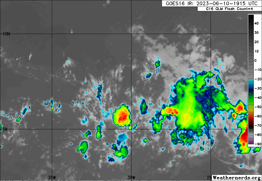
The 11th tropical wave for 2023 is along 50W, south of 12N, moving west at 15 knots (28 KM/H) with scattered weak to moderate convection both ahead and trailing the wave axis. This wave is forecast to move across T&T and the Windwards late Monday, June 12th, into Tuesday, June 13th, 2023.
Though this wave is not forecast to be particularly strong or active, it will be moving across Trinidad and Tobago at a time of weak trade winds, weak wind shear, and relatively high atmospheric moisture.
Low-level convergence and upper-level divergence are not forecast to be strong, while between the 850-millibar and 350-millibar levels, relative humidity levels (another measure of atmospheric moisture) are forecast to be on the drier side, between 55-65%. Combined, it results in less organized and persisting convection, meaning rainfall is forecast, but not persisting, heavy or severe showers and thunderstorms.
Tropical Wave 12
The 12th tropical wave for 2023, as of 8:00 AM Saturday, is located along 30W, moving west at 15 to 20 knots (28-37 KM/H). This wave is forecast to arrive across the southern Windward islands by late Wednesday, June 14th, 2023, into Thursday, June 15th, 2023.
Wind shear is forecast to increase as this wave moves across the area, with relative humidities between the 850-mb and 300-mb levels remaining dry to moderately moist, between 65% and 75%. Similar to TW11, low-level convergence, and upper-level divergence are not forecast to be strong. The result – showers and isolated thunderstorms but no persisting, strong convection.
West African Monsoon
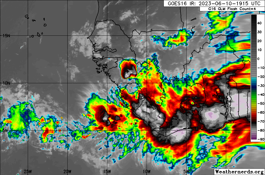
The next tropical wave, yet to be officially analyzed, is likely along the west coast of Africa with moderate to strong convection. Longer range models suggest this wave, while looking quite active presently, is forecast to be another weak tropical wave as it moves across the Atlantic, dealing with increasing shear and Saharan Dust.
Not Every Tropical Wave Brings Severe Weather
Tropical waves vary in intensity as it travels westward across the Atlantic. This variability can be on the order of days to as short term as hours. Sometimes, you may see satellite imagery that shows heavy thunderstorms and deep convective activity east of Trinidad and Tobago during the late night and early morning, but by daybreak – nothing.
This is due to diurnal (daily) variations in convective showers whereby convection peaks overnight and wanes during the day for already occurring convective systems (i.e., not triggered by daytime heating).
Activity can be enhanced by its proximity to upper-level troughs and the ITCZ but can also be degraded by hostile upper-level conditions and Saharan Dust.


