


After a drought of tropical cyclones in the Atlantic Basin for 2022, two new systems have developed in the last 36 hours – Danielle and now, Tropical Storm Earl.
Earl is the fifth-named storm for the 2022 Atlantic Hurricane Season, forming northeast of the Lesser Antilles. After days of being monitored as Invest 91L, the system organized sufficiently to be designated Tropical Storm Earl late Friday night.
Earl is forecast to move north or near the northernmost Leeward Islands and parts of the Greater Antilles through the weekend, with the strongest activity generally remaining north of the region. This tropical storm formed from Tropical Wave 34, which is also forecast to move across the region on Saturday
Specifically for Trinidad and Tobago, while direct impacts are not expected, an atypical wind regime is expected through the weekend, with moisture and light winds moving from the south to the north. There are no alerts, watches, or warnings in effect for T&T from the Trinidad and Tobago Meteorological Service at this time for T&T.
The Latest From The National Hurricane Center
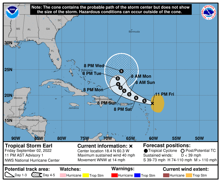
At 11:00 PM AST, the center of Tropical Storm Earl was located near latitude 18.4°N, longitude 60.3°W. Earl is moving toward the west-northwest near 22 KM/H, and this
motion with a decrease in forward speed is expected through early Sunday. A turn toward the northwest with an additional decrease in forward speed is expected Sunday through Monday. On the forecast track, the center of Earl is expected to pass near or north of the northern Leeward Islands on Saturday and north of the Virgin Islands and Puerto Rico Saturday night and Sunday.
Maximum sustained winds are near 65 KM/H with higher gusts. Some strengthening is forecast during the next couple of days.
Tropical-storm-force winds extend outward up to 280 kilometers, mainly to the north and east of the center, with a minimum central pressure of 1005 millibars, according to the National Hurricane Center.
Tropical Storm Earl’s Watches & Warnings
There are no tropical storm watches or warnings in effect for the Leeward Islands or the Greater Antilles.
The National Hurricane Center notes that interests in the northern Leeward Islands, the Virgin Islands, and Puerto Rico should monitor the progress of Earl.
Tropical Storm Earl: Hazards Affecting Land
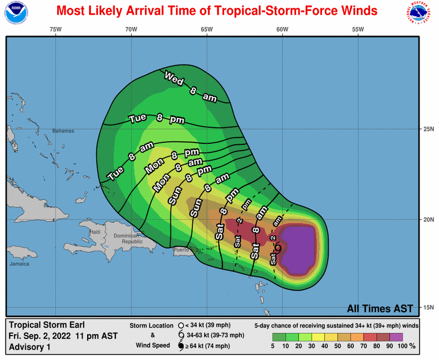
RAINFALL: Earl is expected to produce total rainfall amounts of 2 to 4 inches (50 to 100 millimeters), with isolated totals of 6 inches (150 millimeters), across the Leeward Islands, U.S. and British Virgin Islands, and Puerto Rico through this weekend. Limited flash, urban, and small stream flooding will be possible. Rapid rises on rivers are also possible in Puerto Rico.
WIND: Gusty winds, especially in squalls, are possible across the northern Leeward Islands, the Virgin Islands, and Puerto Rico through the weekend.
This system is of no direct threat to Trinidad and Tobago.
Tropical Storm Earl’s Forecast Discussion

Air Force Reserve and NOAA Hurricane Hunter aircraft each flew missions into the area of low-pressure east of the Leeward Islands this afternoon into this evening, and the data from those flights indicated that the circulation and center of the low became well defined today. Deep convection has also persisted with the low, albeit sheared near and to the east of the center, which means the system has finally met the criteria of a tropical cyclone.
Flight-level, surface, and dropsonde data from the reconnaissance flights all indicate that the system is producing tropical-storm-force winds in the convection well to the east of the center, and for good measure, TAFB provided a Dvorak estimate of T2.5/35 kt. The low is therefore being designated as Tropical Storm Earl with maximum winds of 35 kt. The minimum pressure is estimated to be 1005 mb based on an Air Force dropsonde that measured a surface pressure of 1007 mb with 23-kt winds.
Earl is moving toward the west-northwest or 295/12 kt. The track guidance is in fairly good agreement during the next 3 days, with a low- to mid-level ridge expected to steer Earl west-northwestward and then northwestward at decreasing forward speed. The ridge to the north is forecast to weaken and shift westward around day 3, which should cause Earl to slow down to less than 5 kt and turn northward by day 4, and then north-northeastward by day 5 as it begins to feel the influence of the mid-latitude westerlies to the north. The biggest outliers on days 4 and 5 are the GFS and HMON, which show a stronger Earl moving faster toward the northeast. For now, the NHC official forecast favors a slower scenario on days 4 and 5, closer to the ECMWF, HWRF, HCCA, and TVCN.
Moderate to strong shear is likely to continue affecting Earl for much of the next 5 days, possibly peaking in 3 to 4 days, according to the SHIPS guidance. Mid-level relative humidity ahead of the system also remains lower than what is ideal for strengthening, and as a result, the NHC intensity forecast shows only modest intensification through the forecast period. This forecast is very close to the IVCN and HCCA consensus aids.
Tropical-storm-force winds are forecast to remain on the northern and eastern side of the circulation and, as a result, are not expected to move across the northern Leeward Islands, the Virgin Islands, or Puerto Rico. However, any southward shift of Earl’s center would increase the risk of tropical storm-force winds in those areas.
KEY MESSAGES:
- Tropical storm Earl is forecast to pass near or just to the north of the northern Leeward Islands, the Virgin Islands, and Puerto Rico over the weekend. Gusty winds, especially in squalls, area possible on those islands over the next day or two.
- Heavy rainfall from Earl is expected to lead to limited flash, urban, and small stream flooding over the Leeward Islands, U.S. and British Virgin Islands, and Puerto Rico this weekend. Rapid rises on rivers are possible in Puerto Rico.


