


The first day of a five-day severe weather event brought significant flash floods to parts of northwestern Trinidad on Tuesday, October 25th, 2022.
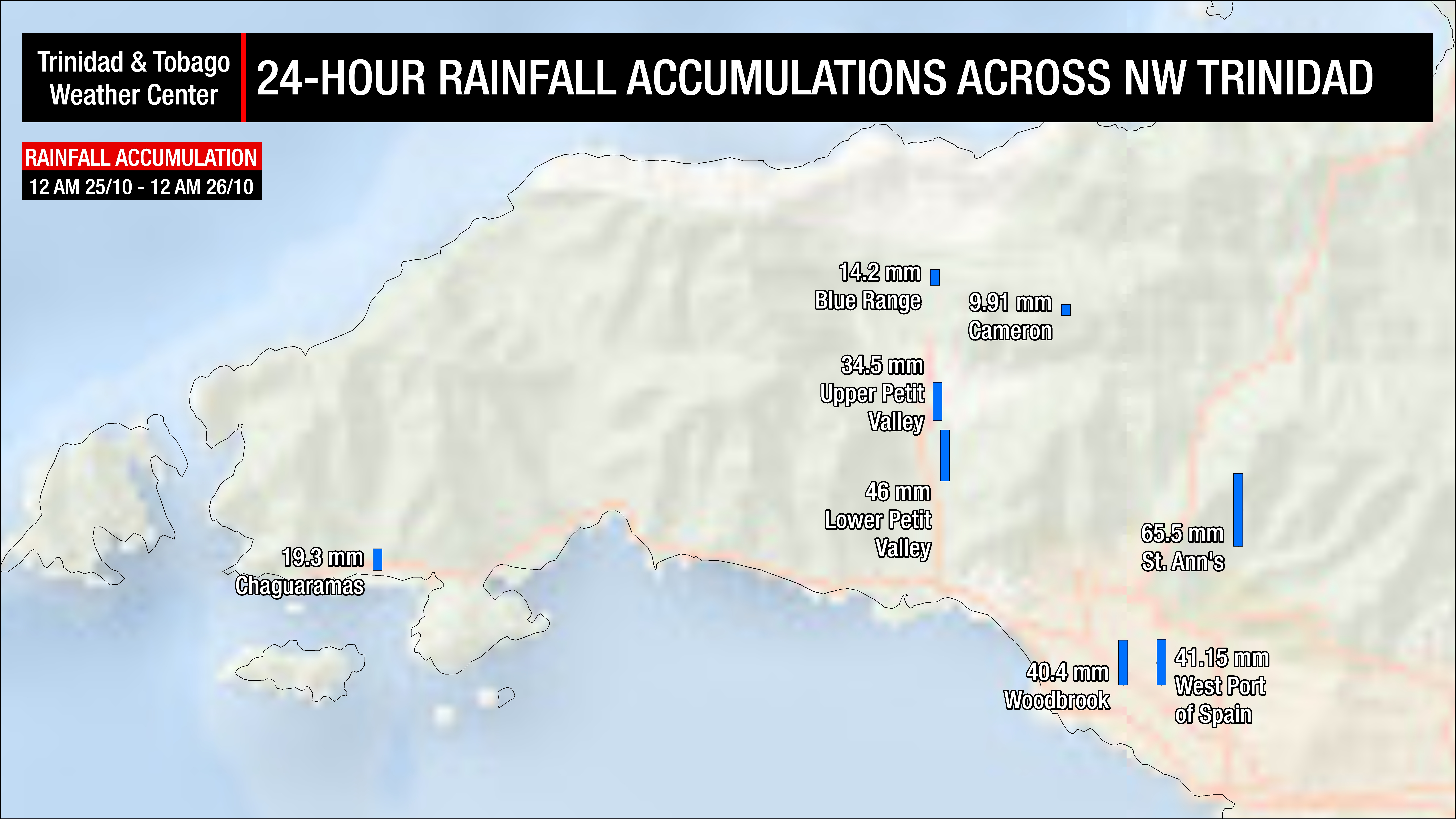
Thunderstorms ahead of Tropical Wave 47 produced rainfall rates exceeding 5 inches per hour (125 millimeters per hour) across parts of Port of Spain, St. Ann’s, and Maraval. Upwards of 2.5 inches (63.5 millimeters) of rainfall were recorded. As drains reached capacity, waters cascaded along St. Ann’s Road and Ariapita Road in St. Ann’s, turning it into a river.
1:00 PM – Flooding ongoing along St. Ann’s Road, St. Ann’s.
— TTWeatherCenter (@TTWeatherCenter) October 25, 2022
Flooding has also been reported in Cocorite, St. James, Maraval, and Long Circular.https://t.co/235fAlNLC7 pic.twitter.com/JF2f6ZHJ3g
A similar situation unfolded in La Seiva, Maraval, as the Maraval River overtopped, rendering many smaller side roads impassable. However, a tributary to the Maraval River crossed Saddle Road, damaging the bridge railing and cutting off motorists in the vicinity of Royal Palm Plaza. Equipment from the Ministry of Works and Transport and a team from the Trinidad and Tobago Fire Service assisted the Diego Martin Regional Corporation (DMRC) in clearing debris late Tuesday afternoon.
1:20 PM – Major flash flooding is ongoing at Saddle Road, Maraval. Debris and flooding has temporarily rendered the roadway impassable. Do NOT venture into flood waters!https://t.co/235fAlvCnZ pic.twitter.com/S5hKem2Mua
— TTWeatherCenter (@TTWeatherCenter) October 25, 2022
The DMRC also reported flooding in Boissiere #1 and #2, with six landslides requiring backhoes and trucks to be dispatched to Fondes Amandes, St. Ann’s, and Fort George Road, St. James. The DMRC responded to one fallen tree, one damage report involving high winds, and a collapsed house at Farrel Lane, Belmont.
According to the Office of Disaster Preparedness and Management, flooding was reported across twelve areas within the Port of Spain City Corporation’s area of responsibility. These included Long Circular Road, Ariapita Avenue, Wrightson Road; Hamilton Holder Street; Panka Street; Vidale Street, St James; Bourne’s Road, St James; Mucurapo Road; Audrey Jeffers Link Road; Jeffers Lane; Cocorite (under the flyover; Western Main Road eastbound (vicinity of the Stuart brothers); Queen’s Park Savannah; the Hollows; and Newton, Maraval Road.
1:10 PM – Flash flooding ongoing at the Queen’s Park Savannah between Maraval Road and Circular Road.https://t.co/235fAlNLC7 pic.twitter.com/8XCmSkPYrB
— TTWeatherCenter (@TTWeatherCenter) October 25, 2022
Four landslides were reported within the San Juan/Lavantille Regional Corporation, one within the Sangre Grande Regional Corporation (SGRC), and one within the San Fernando City Corporation. A fallen tree was also reported within the SGRC’s area of responsibility.
While major rivers remain contained as of Tuesday evening, according to the Ministry of Rural Development and Local Government, 14 sandbags were already distributed within the DMRC, and 32 sandbags were distributed within the SGRC.
T&T Under An Adverse Weather Alert
At the time of Tuesday afternoon’s floods, Trinidad, Tobago, and surrounding marine areas were under a yellow-level Adverse Weather Alert from the Trinidad and Tobago Meteorological Service, which went into effect at 9:00 AM Tuesday. By the mid-afternoon, the Met Office extended this alert until 3:00 PM Saturday, maintaining the yellow alert level.

