


Though development chances from the National Hurricane Center have decreased on Monday, Invest 91L, a tropical disturbance east of Trinidad and Tobago is still forecast to bring unsettled weather to the Windwards by midweek.
Periods of heavy rainfall in shower and thunderstorm activity are possible from Trinidad and Tobago extending northwards to Guadeloupe, accompanied by occasional gusty winds and lightning, while seas may become agitated.
What you need to know
— What is it: A tropical wave (also called a tropical disturbance) is producing widely scattered and disorganized showers and thunderstorms. It is not a tropical depression or tropical storm, but it is being monitored for development by the NHC for tropical cyclone formation. As of 2:00 PM Monday, development chances remain low over the next 48 hours and five days.
— Who will be affected: Rainfall associated with this tropical wave is forecast to affect the Windward Islands and the French Antilles through Friday. Namely, islands from Trinidad and Tobago to Guadeloupe, including Barbados, are in the path of this tropical wave’s rainfall, with elevated winds forecast to affect islands between Barbados and Guadeloupe.
— What can you expect: Street/flash flooding is highly likely. Chances for riverine flooding will increase through the week for T&T. Gusty winds up to and in excess of 55KM/H accompanying heavy showers or thunderstorms are possible mainly north of Barbados, with wind gusts in excess of 45 KM/H likely for all Windward and French Antilles islands, including Trinidad and Tobago. Lightning will accompany thunderstorms. Landslides, mudslides, and rockfalls are possible across the Windwards, with lahars possible in St. Vincent from mid-week. Seas are forecast to become agitated.
— Alerts/Watches/Warnings: There are no alerts, watches, or warnings in effect for Trinidad and Tobago from the Trinidad and Tobago Meteorological Service (TTMS) at this time, though they have issued a statement. The Barbados Meteorological Service issued a Weather Information Statement and has Barbados under a yellow-level alert for excessive rainfall from Tuesday evening and agitated seas on Wednesday. St. Vincent and the Grenadines (SVG) Meteorological Services has issued its own Weather Information Statement for their country. There are no tropical storm or hurricane watches or warnings in effect for any country within the Lesser Antilles at this time.
The latest from the NHC

As of their 2:00 PM Tropical Weather Outlook, the NHC says, “Showers and thunderstorms associated with a tropical wave located several hundred miles east of the southern Windward Islands have changed little in organization during the last several hours. Slow development is possible during the next several days while the wave generally moves westward at 15 to 20 mph, reaching the Windward Islands and the eastern Caribbean Sea by midweek. Interests in the Windward Islands should monitor the progress of the system. “
Development chances for tropical cyclone formation have decreased slightly and are now low over the next 48 hours and five days, at 20% and 30%, respectively.
The National Hurricane Center has scheduled three weather reconnaissance flights on Invest 91L beginning from 2:00 PM Tuesday, October 4th, 2022 (18Z October 4th)
Invest 91L is located approximately 1,000 kilometers east of Trinidad and Tobago. However, dry air ahead of the system has infiltrated Invest 91L’s convection, causing weak and widely scattered showers and thunderstorms.

Though on visible satellite imagery, the circulation looks threatening, it is all happening at the mid-levels of the atmosphere rather than the surface, which was confirmed by a recent scatterometer pass showing little organization at the surface. Invest 91L remains weak with a minimum pressure of 1012 millibars.
Invest 91L’s Forecast

When tropical systems near the Lesser Antilles, all eyes go on the track of the system’s center. However, when these tropical disturbances are weak and disorganized, several things occur:
- The weaker the system is, the more west it travels. Stronger or more organized systems generally take a poleward (northward or northwestward) path.
- Stronger winds generally favor the northern portion of the wave axis or weak circulation. In contrast, the southern portion of the wave or circulation has light to near calm and variable winds.
- Disorganized systems are mainly a rainfall threat over a large area, with sporadic and locally high rainfall totals.
Invest 91L has failed to organize considerably even in generally favorable conditions over the last 24 hours due to dry air infiltrating its convection. However, Tropical Wave 41, the tropical wave associated with this area of disturbed weather, is over 1,500 kilometers long with scattered cloudiness, isolated showers, and thunderstorms.
The general westward movement of Tropical Wave 41 and Invest 91L is forecast to continue though forecast models indicate a marginal increase in latitude as it nears Trinidad and Tobago. It should be noted that while the low-pressure center may track across or near T&T, the strongest winds and overall higher rainfall totals are forecast to remain well north of the country, with light and variable winds across Trinidad and Tobago.
Models generally remain unenthusiastic about the development of this tropical disturbance, although conditions are somewhat favorable. Upper-level conditions are quite favorable through the next 72 hours, with an upper-level low providing favorable upper-level divergence. Low to moderate wind shear is forecast to affect this system through the next three days, and Invest 91L is forecast to traverse very warm sea-surface temperatures between 29°C and 30.5°C on its Windward Islands approach.
Mid to upper-level moisture is forecast to be moderate between Wednesday and Thursday, with relative humidity values between 50% and 65%. Precipitable water values are forecast to exceed 2 inches (50 millimeters) through the week. Combined with a favorable upper-level environment and deep-layered trough, these factors will support scattered showers and periods of rain, with isolated showers and thunderstorms producing heavy/violent rainfall rates.
This weak and broad area of low pressure is forecast to track near or across the country during the first half of Wednesday, with increased cloudiness, showers, and thunderstorms occurring from late Tuesday through Thursday.
The Intertropical Convergence Zone is forecast to move north across the Windwards as this wave traverses the region, supporting showers and thunderstorms through the end of the week.
Invest 91L’s hazards
Given the fairly slow westward movement and largely disorganized nature of the low-pressure area, rainfall and gusty winds are forecast to affect a broad area of the Windwards. Islands from Trinidad and Tobago to Guadeloupe, including Barbados, are in the path of this tropical wave’s rainfall, with elevated winds forecast to affect islands between Barbados and Guadeloupe.
Islands between Trinidad and Tobago, extending northwards to Guadeloupe, including Barbados, should all be monitoring this system and closely monitoring the meteorological alerts, watches, and warnings from your local meteorological offices.
Rainfall and Flooding
Invest 91L is primarily a rainfall threat to the eastern Caribbean.
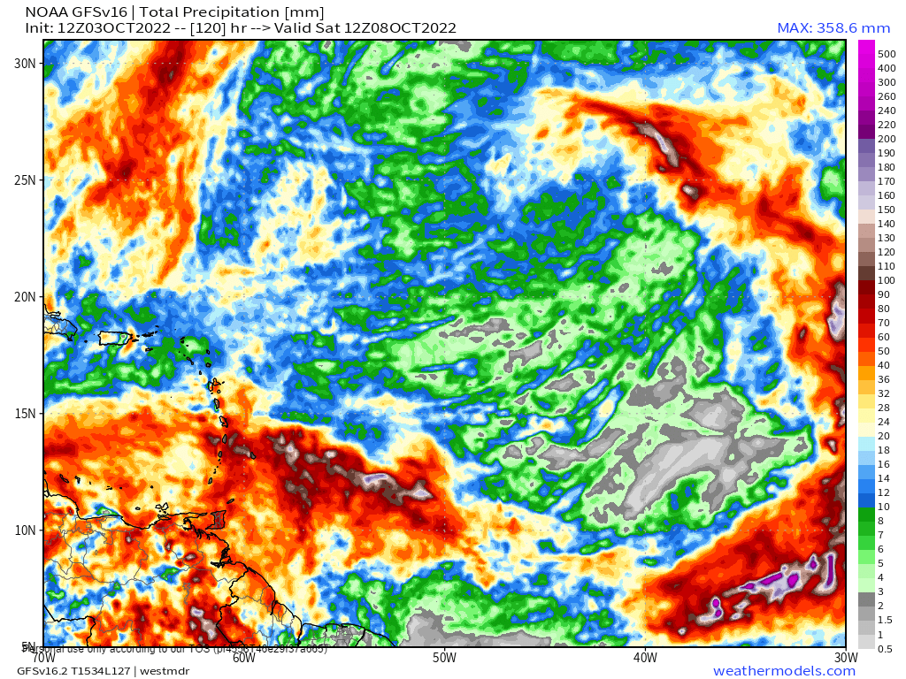
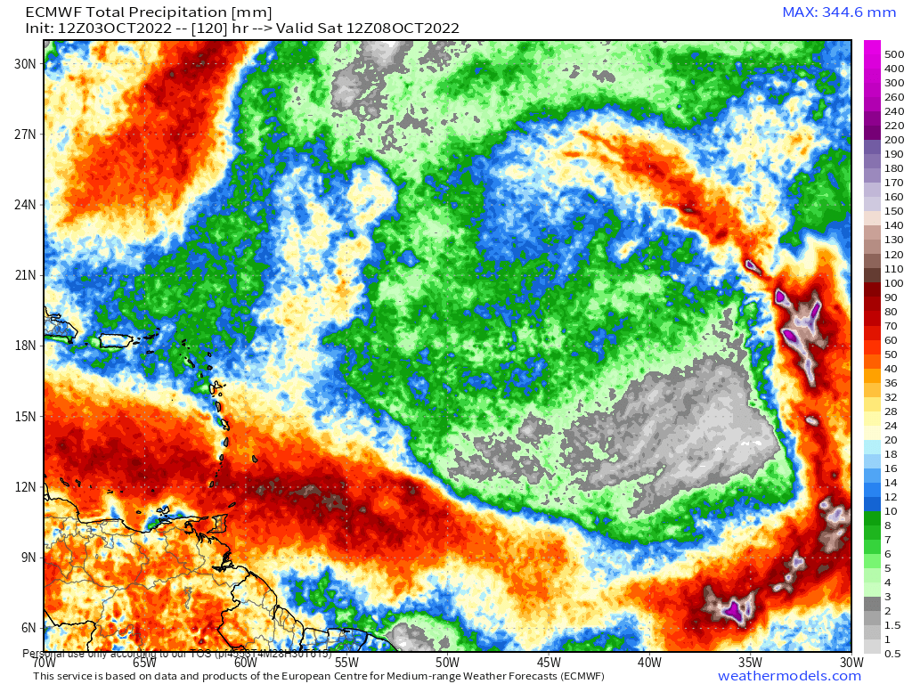
Between 25 and 75 millimeters of rain through Saturday is forecast across the Eastern Caribbean southward of Guadeloupe. Isolated higher totals are possible on islands’ Windward (or Atlantic-facing) slopes. Specifically for Trinidad and Tobago, between 25 and 50 millimeters are forecast across both islands, with generally low totals across northwestern Trinidad, with rainfall totals between 50 and 100 millimeters favoring the southern and eastern halves of Trinidad, as well as across Tobago. In highly isolated areas, rainfall totals over the next five days can exceed 125 millimeters.
Putting the rainfall forecast into context, rainfall rates in excess of 50 millimeters per hour or areas that receive in excess of 25 millimeters within an hour tend to trigger street flooding across the country or flash flooding in northern Trinidad. For riverine flooding to occur, a large area of the country (not just in highly localized areas of western coastal Trinidad) would have to record upwards of 75 millimeters within 24 hours, and rainfall would have to fall across major rivers’ catchment areas.
For all islands, street/flash flooding is like to accompany showers and thunderstorms with heavy to violent rainfall rates. Trinidad’s chances for riverine flooding will increase through Wednesday and Thursday as soils become increasingly saturated and rains continue.
Wind
Elevated winds associated with Invest 91L are forecast to affect islands between Barbados and Guadeloupe mainly. Sustained winds are forecast between 25 KM/H and 40 KM/H, with gusts occasionally exceeding 55 KM/H, generally accompanying showers or thunderstorms.
Possible impacts include localized wind damage to trees, power lines, and small structures. Light outdoor objects may topple or become airborne such as garbage cans, potted plants, loose galvanize or construction material, and other outdoor furniture. Tents may jump. Older/weaker trees may fall, bringing down utility poles and lines.
Seas & Surf
Seas across Trinidad and Tobago are forecast to be agitated but generally remain moderate in open waters with waves up to 2.0 meters. North of T&T and particularly seas east and north of Barbados, waves in open waters could exceed 2.5 meters.
These waves can produce hazardous marine conditions for small craft and sea bathers.
Landslides
With the forecast rainfall accumulations, landslides, mudslides, and rockfalls are possible across islands from Guadeloupe to Trinidad and Tobago. Lahars are also possible in St. Vincent’s orange and red zones.
Tornadoes
A few funnel clouds are possible, mainly through Wednesday, due to light and variable winds, particularly across Trinidad and Tobago, as well as Grenada and its dependencies. If a funnel cloud touches down on a body of water, it becomes a waterspout; if it touches down on land, it becomes a tornado.
What should you do?
As an individual, there are a couple of things you can do as we head through the peak of the 2022 Atlantic Hurricane Season:
- Stock your emergency kit
- Clean your surroundings and gutterings
- Secure light or loose objects outdoors
- If your roof is unsecured, purchase and install hurricane straps
- Clear larger trees near your home
- Ensure you have batteries and battery packs for your flashlights, radios, and mobile devices
- Ensure you have sufficient gas for gas-powered stoves and vehicles
- Ensure you have adequate dry foods and water to rally through an extended power outage (generally, the rule of thumb is 72 hours).
- Stock up on candles and mosquito repellant.
- Ensure you have alternative means of communication (like a battery-powered radio) if the internet or television goes down.
- Have a trusted source of information for the latest news before, during, and after a storm.
For the next 48 hours, it is important to remain indoors during gusty winds associated with showers and thunderstorms, as light objects outdoors could become airborne. Avoid venturing into flood waters. Plan for your commute and expect traffic disruptions due to fallen trees, landslides, and flooding. Avoid entering the sea if not necessary.
Elsewhere in the Atlantic

Looking further east, the National Hurricane Center has tagged Tropical Wave 42 for development, now designated Invest 92L. As of their 2:00 PM Tropical Weather Outlook, the NHC says, “Showers and thunderstorms have increased today in association with an area of low pressure located a few hundred miles south-southwest of the Cabo Verde Islands. Environmental conditions are conducive for gradual development, and a tropical depression is likely to form in a day or two. Further development will become less likely late this week due to increasing upper-level winds. The system is forecast to move west-northwestward and then turn northwestward by mid-week over the eastern tropical Atlantic.”
Development chances are medium for tropical cyclone formation over the next 48 hours and high over the next five days, at 60% and 70%, respectively. Julia and Karl will be the next named storms for 2022 in the Atlantic basin.


