


While seas are forecast to generally remain moderate across Trinidad and Tobago through the next seven days, elevated winds associated with an approaching tropical disturbance are forecast to agitate seas by mid-week. Additionally, spring tides are forecast to return by the end of the week, which may slow runoff as heavy rainfall is forecast across the country into the upcoming weekend.
There are no sea-based alerts, watches, or warnings from the Trinidad and Tobago Meteorological Service for Trinidad and Tobago at this time.
Seas Forecast For Trinidad and Tobago
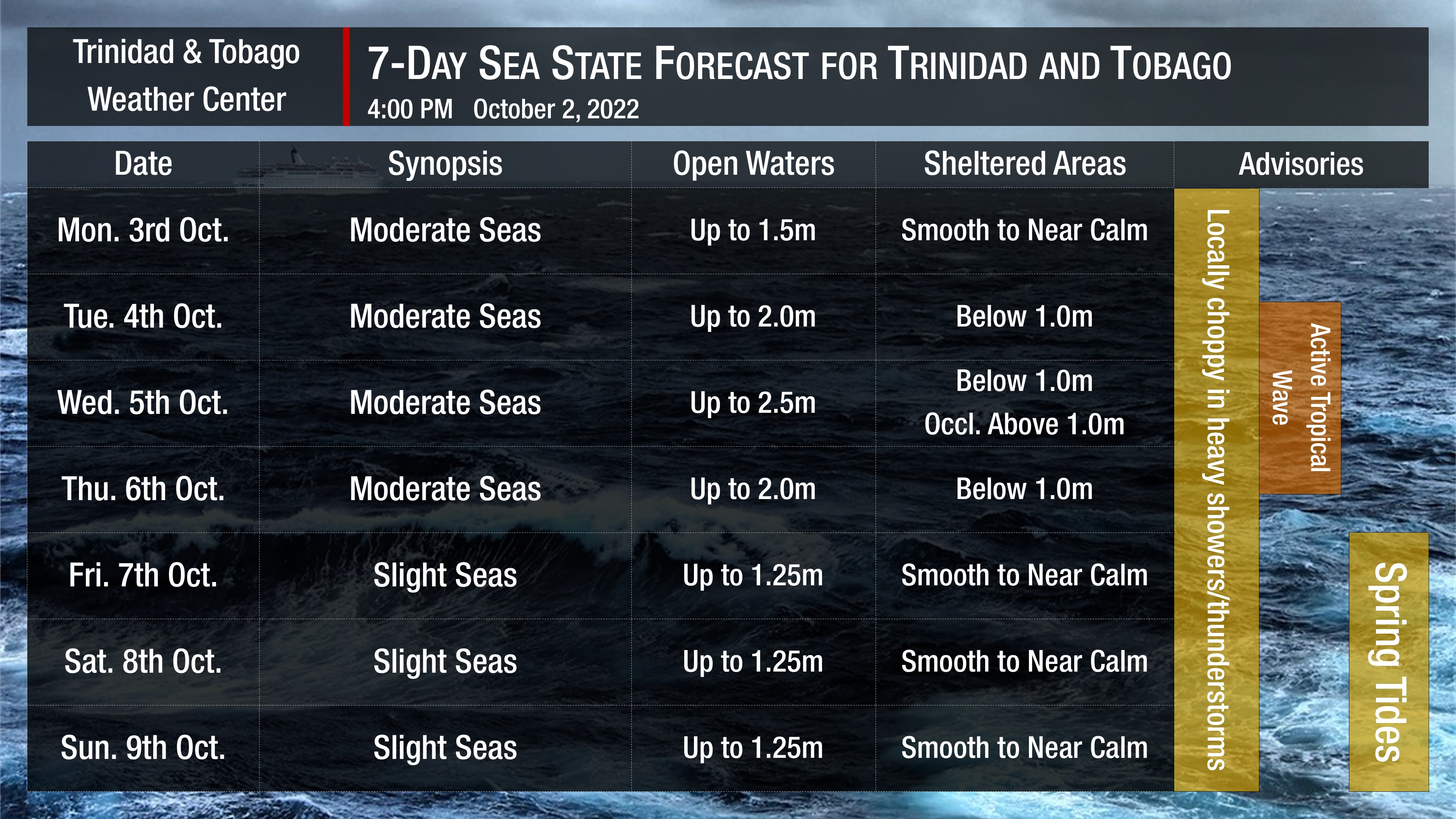
On Monday and through mid-Tuesday, seas are forecast to generally be moderate in open waters with waves up to 1.5 meters and less than 0.5 meters in sheltered areas. Swell periods are forecast to be moderate, up to 9 seconds from the northeast. Winds are forecast to generally be less than 15 knots from the east to northeast, with gusts up to 20 knots accompanying shower or thunderstorm activity.
By Tuesday evening, elevated winds trailing the passage of a low-level to surface trough and ahead of Invest 91L, a tropical disturbance spawned from Tropical Wave 41, will begin to affect the Windward Islands.
For Trinidad and Tobago, the country is forecast to remain on the southern portion of the wave axis, and across the country and our coastal waters. Still, waves in open waters, mainly north of Trinidad and Tobago, could reach 2.5 meters, while in sheltered areas, waves could occasionally top 1.0 meter. Wind speeds are forecast to remain less than 10 knots, with a general northeasterly direction on Tuesday night, becoming northerly overnight into Wednesday, and then southerly to southeasterly by Wednesday afternoon into Thursday. Gusts could exceed 25 knots, accompanying showers and thunderstorms. Swell periods are forecast to remain moderate, below nine seconds.
By late Thursday and into the weekend, winds are forecast to return to the usual gentle to moderate speeds, with sustained winds between 5 to 15 knots from generally the southeast to the northeast. Gusts during this period are forecast to reach 20 knots, accompanying isolated heavy showers or thunderstorms.
Spring tides are forecast to begin on October 7th, 2022. These are higher than usual high tides and lower than usual low tides which may increase the risk of rip currents. Spring tides may also lead to slower runoff of floodwaters and slower decrease of river levels.
How to spot a rip current

Rip Currents
Saharan Dust is also forecast to increase by Monday, mainly for islands north of Trinidad and Tobago. However, visibility and air quality across Trinidad and Tobago are not forecast to be significantly affected.


