


The Trinidad and Tobago Meteorological Service (TTMS) is forecasting hazardous long-period swells to affect predominantly T&T’s northern and eastern coastlines through Monday. However, forecast models indicate a more prolonged swell event set to kick off from Wednesday.
Latest Alert

Hazardous Seas Alert Discontinued For T&T
Trinidad and Tobago is NOT under any tropical storm or hurricane threat, watch, or warning at this time.
Seas Forecast For Trinidad and Tobago

Sunday: Seas are forecast to be slight to moderate in open waters, with waves up to 1.5 meters, while in sheltered areas, waves remain between 0.5 meters and 1.0 meter and occasionally choppy. Winds across Tobago are forecast to range between 10 knots to 15 knots from the northeast, gusting just above 15 knots at times, while across Trinidad, winds are forecast to be less than 10 knots; with most areas, winds are forecast to be light to near calm with a variable direction. The TTMS is forecasting swell periods of up to 15 seconds, leading to high-energy, large waves along T&T’s northern and eastern coastal areas. A Hazardous Seas Alert is in effect.
Monday: Seas are forecast to be moderate in open waters, with waves between 1.5 meters and 2.0 meters. In sheltered areas, waves are forecast to be near 1.0 meter and choppy, particularly in the vicinity of heavy showers or the occasional thunderstorm by the evening. Winds are forecast to range between 10 knots and 20 knots from the east to northeast, gusting to 25 knots, mainly in the vicinity of showers or evening/nighttime thunderstorms. The TTMS is forecasting swell periods of up to 15 seconds, leading to high-energy, large waves along T&T’s northern and eastern coastal areas. A Hazardous Seas Alert is in effect until noon (12:00 PM).
Tuesday: Seas are forecast to be moderate open waters, with waves generally between 1.5 and 2.0 meters. In sheltered areas, waves are forecast to be below 1 meter and with choppy conditions in the vicinity of heavy showers/thunderstorms. Swell periods are forecast to range between 8 and 11 seconds. Winds are forecast to be between 10 knots and 15 knots from east to northeast, with gusts up to 20 knots.
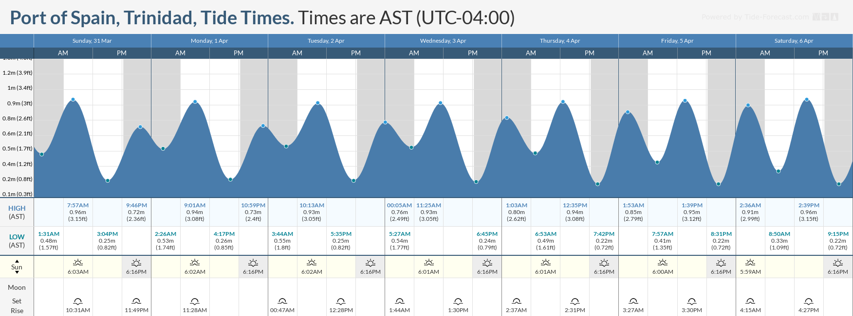
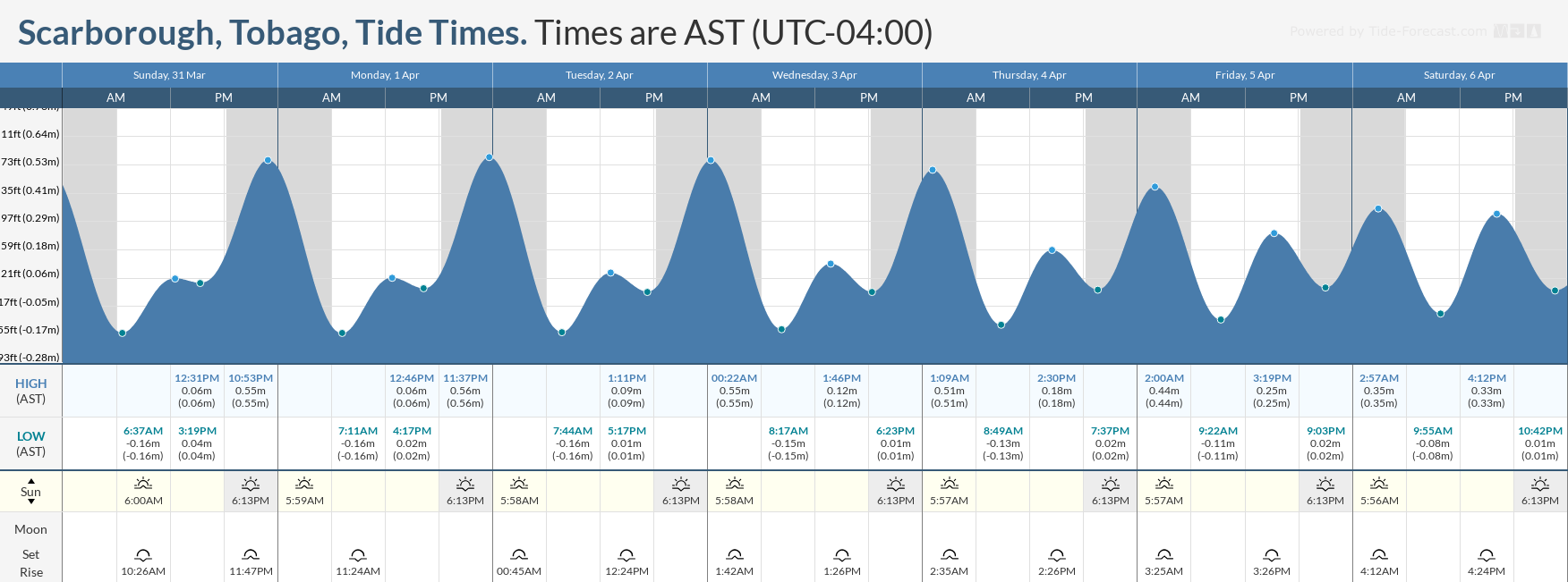
Wednesday through Saturday: Seas are forecast to be moderate in open waters, with waves between 1.5 and 2.0 meters. In sheltered areas, waves are forecast to be near 1.0 meter and choppy due to a combination of long-period swells and gusty winds in the vicinity of isolated heavy showers/thunderstorms. Swell periods are forecast to range between 10 and 16 seconds. Winds are forecast to range between 15 and 20 knots from the northeast to east-southeast, gusting to 25 knots. Stronger winds are forecast generally from Wednesday evening through Friday morning. Spring tides are also set to begin from Friday.
Possible Impacts
Through the forecast period, marine interests along northern coastlines will need to exercise caution due to long-period swells Sunday through mid-Monday, and again from Wednesday through the end of the forecast period.
Large battering waves in nearshore areas can be hazardous to some vessels, particularly for smaller craft operations, which can be difficult during this time. In nearshore areas, northerly swells will also pose a hazard for all mariners and beachgoers.
There will be an elevated risk of rip currents through the forecast period, particularly along northern and eastern coastlines. If caught in a rip current, swim perpendicular to the current (parallel to the shore). Mariners, especially small craft operators, should ensure their vessels are securely anchored or docked as choppy/breaking wave conditions may drag the vessel onto the ocean floor or reefs in shallow waters or even break anchorage/mooring.
Spring tides, which are higher-than-usual high tides and lower-than-usual low tides, will peak near April 8th, the night of the New Moon. Mariners and beachgoers will need to exercise caution at both low and high tide levels.
Saharan Dust concentrations are forecast to increase by Thursday, leading to some decrease in horizontal visibility, particularly during dawn and dusk.


