Two new active vents of the Cascadoux Mud Volcano erupted in Cascadoux Trace, Cascadoux Village, Mayaro, on Thursday evening at approximately 5:00 PM, prompting the evacuation of three homes closest to the new vents.
What you need to know
— A mud volcano erupts: Two new vents of the Cascadoux Mud Volcano, located just north of Mayaro, southeast Trinidad, have erupted, prompting the evacuation of three nearby homes. There have been no reports of injuries to people or livestock or property damage.
— Authorities respond: The Mayaro Rio Claro Disaster Management Unit, as well as officials from the T&T Fire and Police Service, were onsite.
— Current activity: As of late Thursday night, the earlier explosive eruption had ceased, with occasional venting (mud erupting up to a few feet in the air).
— Further threat: It is too soon to tell if this eruption is over or if there will be additional venting. Experts from the University of the West Indies will conduct comprehensive assessments. Authorities are asking the public to refrain from visiting the area at this time as access to the immediate area has been restricted
Last update: 10:30 AM Friday, January 12th, 2024.
According to reports in the area, hot mud began spewing into the air on Thursday afternoon, with residents reporting mud reaching as high as 15 feet in the vicinity of LP #120 Cascadoux Village, Mayaro. Though there are homes nearby, there have been no reports of any structural damage or injuries to people and livestock at this time.
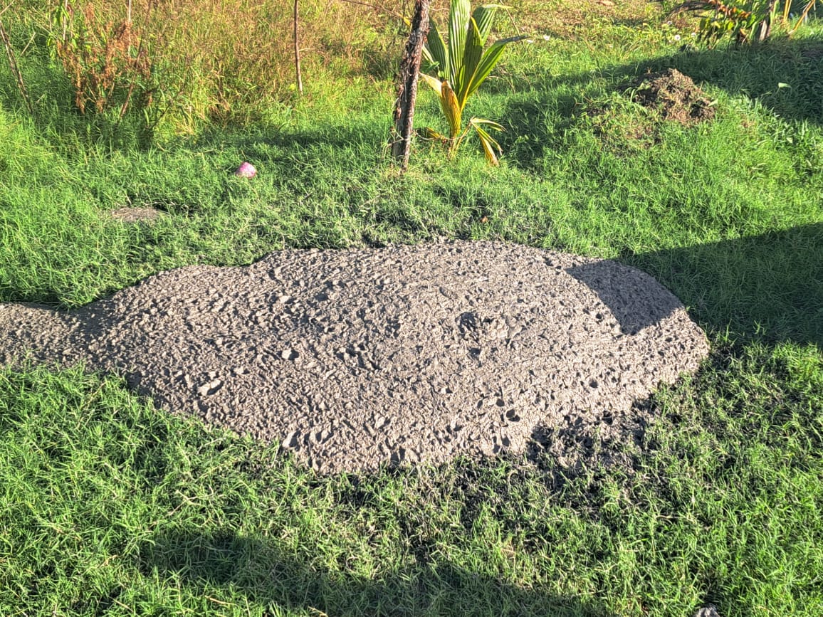
The new vents have created circular areas of fresh mud spanning approximately two feet in width and four feet in length. However, based on the latest observations, gas is being emitted with mud every 63 seconds.
The Disaster Management Unit attached to the Mayaro/Rio Claro Regional Corporation (MRCRC DMU) has confirmed the incident. The Mayaro branches of the Trinidad and Tobago Fire Service and Trinidad and Tobago Police Service have also aided in the evacuation of three families.
According to the councillor for the area, Renelle Kissoon, the families were evacuated into neighbouring homes or homes of relatives. On Friday morning, the member of parliament for the area, Rushton Paray, indicated that preparations have been made at the Mayaro Civic Center, which stood ready to serve as a shelter should the need arise.
The Office of Disaster Preparedness and Management (ODPM) and the Ministry of Rural Development and Local Government National Disaster Coordinator have been informed and are monitoring the situation.
The Cascadoux Mud Volcano
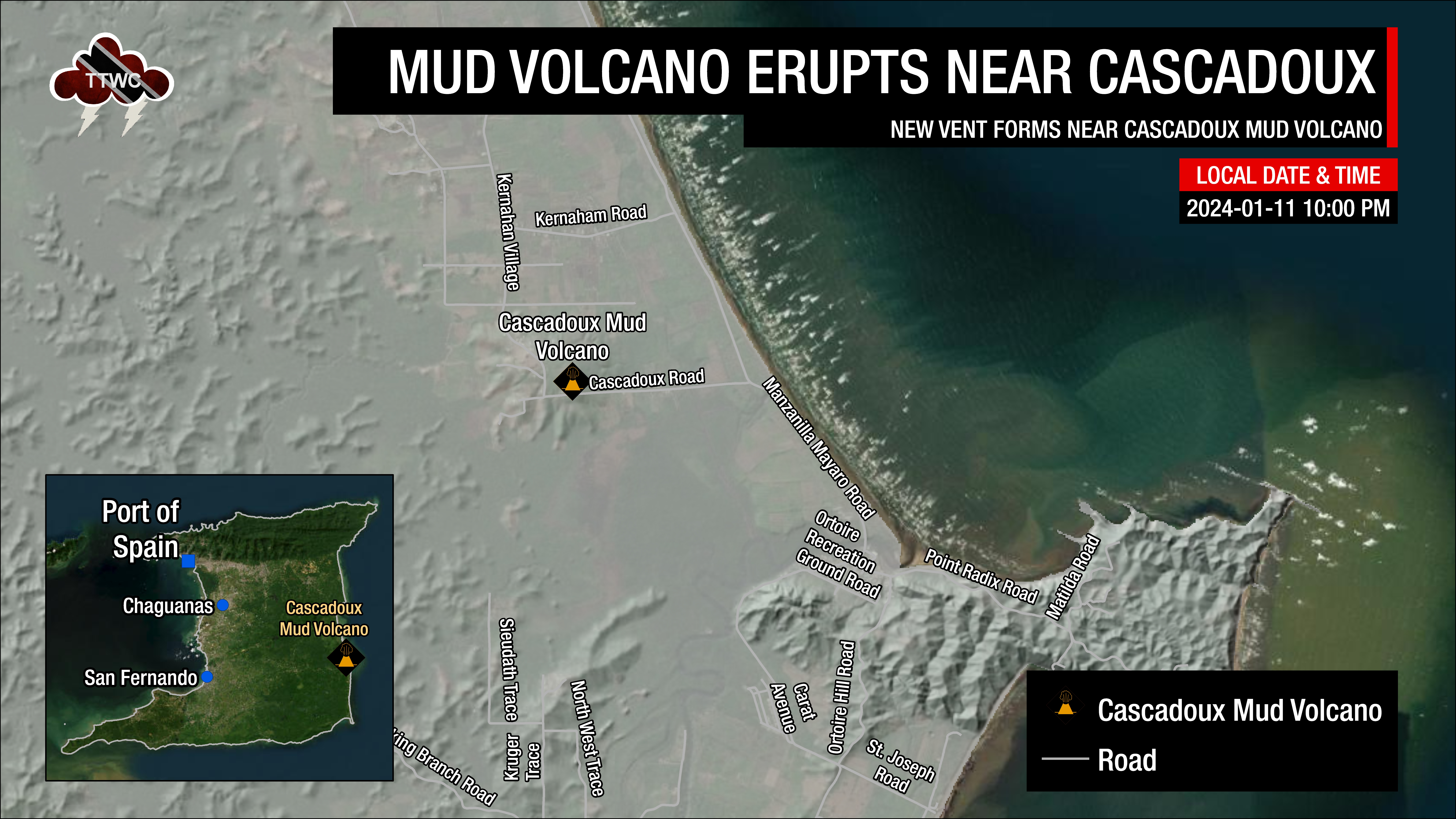
The Cascadoux Mud Volcano is located approximately 1.35 kilometers off the Mayaro-Manzanilla Road on Cascadoux Trace, Mayaro.
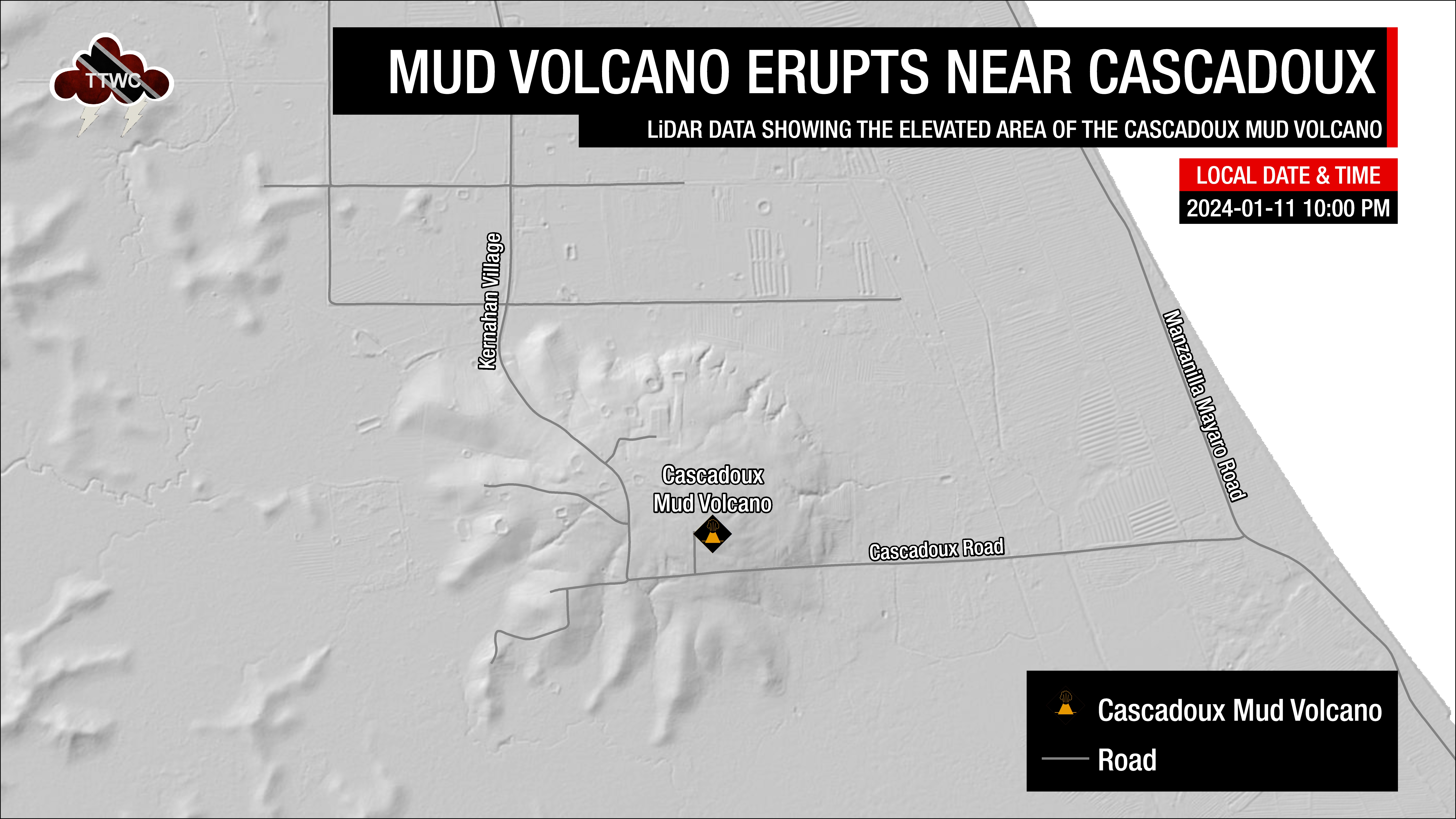
According to local geologist Curtis Archie, this mud volcano does not have a tassik (an open area on the ground, surrounded by forest, where mud and gases rise up to the surface). Still, there are several small cones on the apex of the hill that rise approximately 30 meters above the surrounding land.

Archie visited the area just a few days ago, and noticed two vents that were developing within 160 feet away from the main vent. This activity is typical with larger mud volcanoes that do not have a central vent. Other examples include the current (as of early 2024) forms of the Piparo and Devil’s Woodyard mud volcanoes located well west of Cascadoux.
Prior to this eruption, the Cascadoux Mud Volcano was generally comprised of two major cones, just under a meter high, where mud, oil and gas would erupt from. Most of the eruptions were small and mainly oozed out from smaller vents along the side of the cone.
The Geological History
According to geologist Xavier Moonan, The Cascadoux Mud Volcano is located along the Debe Wellington Anticline, a subsurface folded feature or buried hill that runs across the breadth of Trinidad. The Debe Wellington Anticline derives its name from the hill feature noted in the town of Debe, and it parallels, to some extent, the Wellington Road. This anticline makes its way across the country to the east coast, where the Cascadoux Mud Volcano occurs at its crest at the intersection with a significant easterly dipping tear fault.
Mud Volcanoes in Trinidad and Tobago
A mud volcano or mud dome is a landform created by the eruption of mud or slurries, water and gases – typically methane. Several geological processes may cause the formation of mud volcanoes. In Trinidad and Tobago, mud volcanoes exclusively exist across the southern half of Trinidad due to the specific geological processes that require them to form.
According to the Geological Society of Trinidad and Tobago in a recent Newsday article, Mud volcanoes tend to occur in zones that have thick layers of clays, oil and natural gas, where rocks are also being squeezed or compressed. The Trinidad area is within such a zone, between the South American and Caribbean Plates, where the Caribbean Plate is sliding horizontally past the South American plate. This type of plate boundary is called a transform plate boundary, and since no plate is being subducted beneath each other, no melting or volcanic activity can take place.
The horizontal motion, however, causes compression, and this is what created Trinidad’s modern-day Central and Southern Ranges – a discontinuous chain of low hills where most of the mud volcanoes occur. The compression within these hills is responsible for the buildup of the pressure of the trapped oil and natural gas within the rocks, primarily made up of clays. When the pressure reaches a critical level, it is released through weaknesses or faults in the rocks and rises to the surface through these faults, forming mud volcanoes.
Mud volcanoes are not true igneous volcanoes as they do not produce lava and are not necessarily driven by magmatic activity. The temperature of any given active mud volcano generally remains fairly steady and is much lower than the typical temperatures found in igneous volcanoes.
They may range in size from merely one or two metres high and one or two metres wide to 700 metres high and 10 kilometres wide. Smaller mud exudations are sometimes referred to as mud pots.
On land in Trinidad, there are just under 60 known mud volcanoes that scatter the southern half of the island. Many of them currently show no activity, while others ooze liquid mud, muddy water, bubbles or natural gas. Occasionally, there are large eruptions that last a few minutes, with the most recent occurring at the Devil’s Woodyard in 2018 and in Tabaquite in 2019. Off Trinidad’s east coast, hundreds of mud volcanoes can be found on the seafloor, some as large as Naparima Hill in San Fernando.