


In a very late-notice move, the Trinidad and Tobago Meteorological Service has issued an Adverse Weather Alert for both Trinidad and Tobago as heavy showers and thunderstorms are forecast to affect the country today (Tuesday).
What you need to know
— Rainfall: Through Tuesday night, additional periods of rain with isolated to scattered moderate to heavy showers and thunderstorms are forecast, interrupting mostly cloudy skies. Rainfall totals between 5 and 15 millimeters are forecast across the country, with totals between 15 and 35 millimeters possible across Trinidad. Locally higher amounts (between 50 and 100 millimeters) are possible in areas with persisting heavy showers or thunderstorms, favoring eastern Trinidad.
— Hazards: The main hazards will be street and flash flooding in heavy showers and thunderstorms, accompanied by gusty winds up to 55 KM/H. Localized wind and lightning damage, such as fallen trees and roof damage, are possible. Seas are forecast to become locally agitated during heavy showers or thunderstorms. Landslides are also possible in elevated areas. Although not explicitly mentioned, with the forecast rainfall totals, river basins across Trinidad will have to be closely monitored.
Latest Alerts

High Wind Alert Remains In Effect For T&T
Trinidad and Tobago is NOT under any tropical storm or hurricane threat, watch, or warning.
The Adverse Weather Alert
The Trinidad and Tobago Meteorological Service issued an Adverse Weather Alert (Yellow Level) on Monday at 11:43 PM. The alert retroactively went into effect for Trinidad and Tobago at 11:00 PM on Monday, November 6th, 2023, and remains in effect through 2:00 PM on Tuesday, November 7th, 2023.
Note that although this alert was issued at 11:43 PM Monday and retroactively went into effect, as of 2:00 AM Tuesday and at the time of publishing this article, it hasn’t appeared on the TTMS’ website. However, the alert has been received by international partners, including the World Meteorological Organization.
Trinidad and Tobago is not under any tropical storm watch or warning.
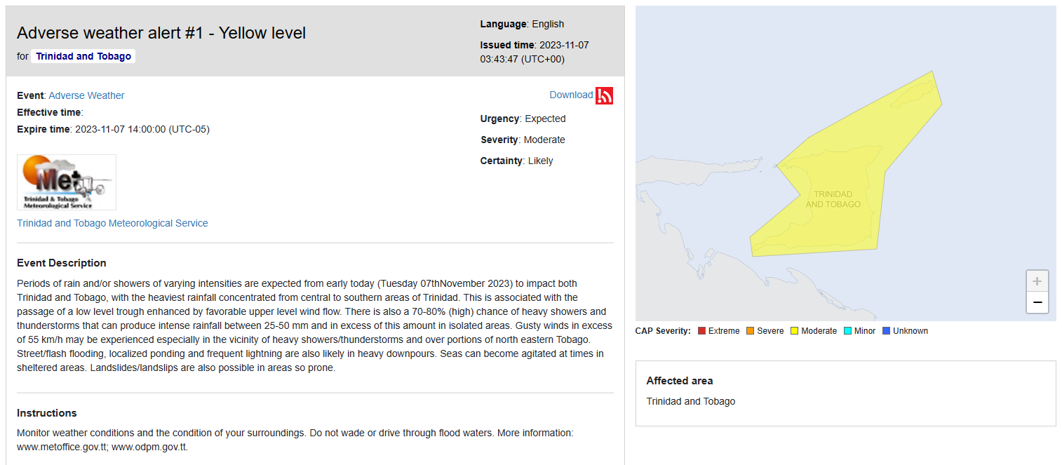
The forecast inclement weather is due to the passage of a low-level trough enhanced by favorable upper-level conditions.
This “alert” status takes into account the possibility of the event occurring. This adverse weather event is likely to have the following impacts, according to the TTMS:
- Periods of rain and/or showers of varying intensities are expected from early today (Tuesday, November 7th, 2023) to impact both Trinidad and Tobago, with the heaviest rainfall concentrated from central to southern areas of Trinidad.
- There is also a 70-80% (high) chance of heavy showers and thunderstorms that can produce intense rainfall between 25-50 mm and in excess of this amount in isolated areas.
- Gusty winds in excess of 55 km/h may be experienced, especially in the vicinity of heavy showers/thunderstorms and over portions of northeastern Tobago.
- Street/flash flooding, localized ponding, and frequent lightning are likely in heavy downpours.
- Seas can become agitated at times in sheltered areas.
- Landslides/landslips are also possible in areas so prone.
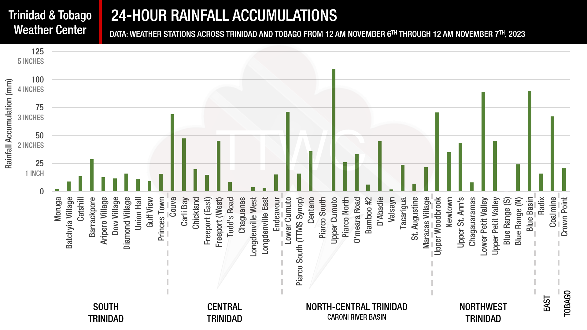
On Monday, Between 12.5mm (0.5 inches) and 37.5mm (1.5 inches) of rain fell across Trinidad and Tobago, with isolated totals between 50mm (2 inches) and 100mm (4 inches) recorded across parts of the Caroni and North Oropouche River Basins.

The color of the alert indicates the severity of the event and the probability of the event occurring. Currently, the alert level is Yellow. This means that the hazards have been observed, and the severity of the impacts is moderate for this particular alert. You should be aware of the hazards in your area associated mainly with gusty winds in excess of 45 KM/H, as well as frequent lightning.
For a moderate Adverse Weather Alert, there is the potential for possible injuries, where behavioral changes are required to ensure safety. There may be minor damage to property, with income-earning temporarily disrupted and a couple of communities affected.
The Met Office is advising the public to monitor weather conditions and the condition of their surroundings. Do not wade or drive through flood waters.


