


A broad area of low pressure along Tropical Wave 32 is being monitored by the National Hurricane Center (NHC). It is forecast to move across the Windward Islands overnight tonight (Wednesday) into tomorrow (Thursday). This disturbance has already begun to affect the southern Windward Islands with periods of showers and isolated thunderstorms.
What you need to know
— What is it: A tropical wave (also called a tropical disturbance) with a broad area of low pressure that formed out of the Intertropical Convergence Zone. It is not a tropical depression or tropical storm, but it is being monitored for development by the NHC for tropical cyclone formation after entering the Caribbean Sea.
— Who will be affected: Rainfall associated with this tropical wave is forecast to affect the southern and central Windward Islands, as well as the French Antilles over the next 48 hours. Namely, islands from Trinidad and Tobago to Guadeloupe, inclusive of Barbados.
— What can you expect: The main hazards associated with this system will be periodic showers and thunderstorms with isolated heavy to violent rainfall rates. Street/flash flooding may accompany these higher rainfall rates. Gusty winds up to and over 45 KM/H are possible for T&T and likely for islands north of T&T, accompanying heavier showers and thunderstorms. Lightning will accompany thunderstorms. Landslides and rockfalls are possible in elevated areas.
— Alerts/Watches/Warnings: There are no alerts, watches, or warnings in effect for Trinidad and Tobago from the Trinidad and Tobago Meteorological Service at this time. The Barbados Meteorological Service issued a statement on the disturbance, advising that flood watches or warnings may be required at short notice for Barbados, where no alerts, watches, or warnings are in effect at this time. A flash flood watch has been issued for St. Vincent and the Grenadines. There are no tropical storm or hurricane watches or warnings in effect for any eastern Caribbean country.
The latest from the NHC
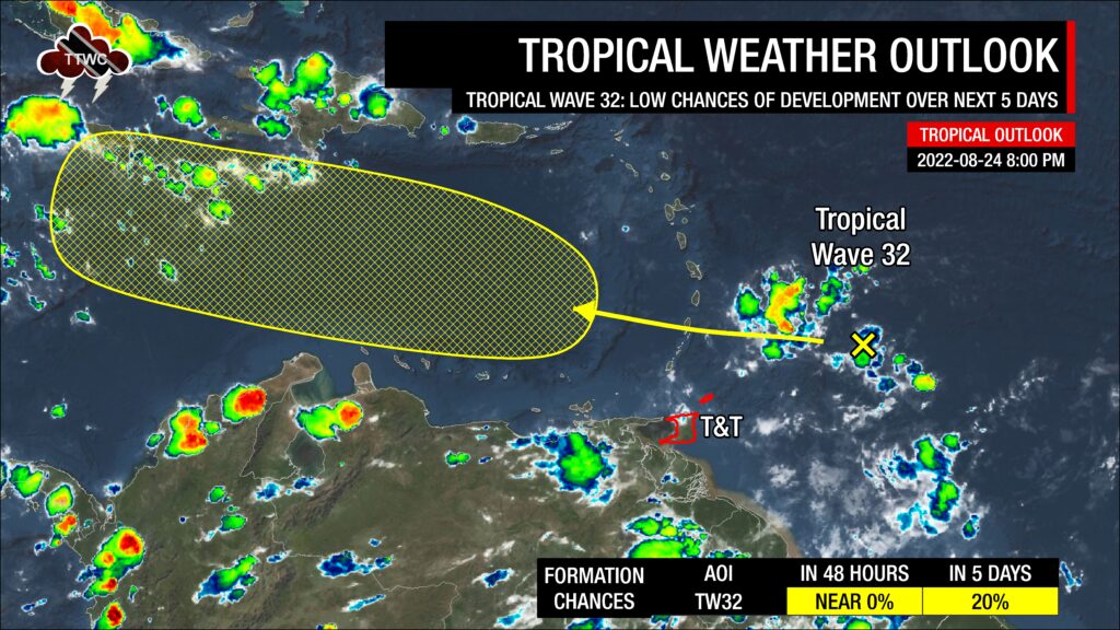
As of their 8:00 PM Tropical Weather Outlook, the NHC says, “Shower and thunderstorm activity remains disorganized associated with a tropical wave located a few hundred miles east of the Windward Islands. Environmental conditions could become more conducive for the slow development of this system in several days after it crosses the Windward Islands and moves across the eastern and central Caribbean Sea late this week into early next week.”
They give the disturbance a low chance of development over the next 48 hours and five days at near 0% and 20%, respectively.
The approximate center of the disturbance is located approximately 500 kilometers northeast of Tobago, though scattered showers and thunderstorms are widely scattered around this broad area of low pressure.
Who will be affected?

In the short term, the approximate center of this broad area of low pressure is forecast to track across Barbados, then St. Vincent and St. Lucia, into the Caribbean Sea. However, with these broad and disorganized systems, impacts extend well beyond the “center” of this tropical disturbance.
The associated tropical wave is forecast to bring showers, thunderstorms, and periods of rain to islands as far south as Trinidad and Tobago to as far north as Guadeloupe. However, forecast models have honed in on areas between St. Vincent and Guadeloupe, including Barbados, for the highest rainfall accumulations.
As this system moves into the Caribbean Sea, dry mid-level air plaguing the Atlantic Basin is forecast to limit any further organization. Most models have stopped developing this system as it tracks south of the Greater Antilles through the weekend, but conditions could become more favorable as it moves into the northwestern Caribbean Sea by the middle of next week.
Tropical Wave 32’s hazards


This system is primarily a rainfall threat to the eastern Caribbean. Forecast models indicate between 15-25 millimeters accumulating over the next 72 hours from Trinidad and Tobago to Guadeloupe.
The highest rainfall accumulations directly associated with this tropical disturbance are forecast to occur across Barbados, St. Vincent, St. Lucia, Martinique, and Dominica, with totals between 25-50 millimeters and isolated areas receiving locally higher amounts, up to 75 millimeters. These higher totals are possible on islands’ Windward (or Atlantic-facing) slopes. Street/flash flooding is possible in heavier showers/thunderstorms or areas that receive prolonged rainfall.
For Trinidad and Tobago, the Intertropical Convergence Zone and localized climatic effects will also contribute to shower/thunderstorm activity. Rainfall accumulations between 15-25 millimeters are forecast across both islands, with isolated totals up to 50 millimeters over the next 72 hours. Similarly, street/flash flooding is possible through Saturday, with chances for riverine flooding low at this time. Major rivers are elevated across eastern Trinidad.
Gusty winds up to and over 45 KM/H are possible for T&T and likely for islands north of T&T, accompanying heavier showers and thunderstorms. Lightning will accompany thunderstorms. Landslides and rockfalls are possible in elevated areas.
As a fairly light and variable wind regime is in place across the eastern Caribbean, funnel cloud development is possible. If a funnel cloud touches down on a body of water, it becomes a waterspout; if it touches down on land, it becomes a tornado. On Wednesday, a funnel cloud was spotted east of St. Philip, Barbados.
What should you do?
No tropical storm or hurricane is bearing down on Trinidad, Tobago, or the remainder of the Lesser Antilles. This system is forecast to be just another tropical wave moving through the Lesser Antilles with the typical unsettled weather we see during the Wet Season.
As an individual, there are a couple of things you can do as we head through the peak of the 2022 Atlantic Hurricane Season, though there are no organized tropical cyclones on our horizon:
- Stock your emergency kit
- Clean your surroundings and gutterings
- Secure light or loose objects outdoors
- If your roof is unsecured, purchase and install hurricane straps
- Clear larger trees near your home
- Ensure you have batteries and battery packs for your flashlights, radios, and mobile devices
- Ensure you have sufficient gas for gas-powered stoves and vehicles
- Ensure you have adequate dry foods and water to rally through an extended power outage (generally, the rule of thumb is 72 hours).
- Stock up on candles and mosquito repellant.
- Ensure you have alternative means of communication (like a battery-powered radio) if the internet or television goes down.
- Have a trusted source of information for the latest news before, during, and after a storm.
Elsewhere in the Atlantic

The NHC is also monitoring Tropical Wave 34, another tropical disturbance moving off the African coast into the Atlantic Ocean, for tropical cyclone development. According to the NHC in their 8:00 PM Tropical Weather Outlook, “Environmental conditions could support some slow development of this system late this week or over the weekend while it moves westward at 10 to 15 MPH.”
The Atlantic Basin, although we are heading into the climatological peak of the Hurricane Season, remains fairly hostile with anomalously strong wind shear and dry mid to upper-level air suppressing shower and thunderstorm development. Models are not enthusiastic about the development of this tropical wave at this time, with the NHC giving it a low chance (20%) of development over the next five days. It is too soon to tell how and if this system affects the Lesser Antilles.


