


On Thursday, and to a lesser extent on Friday, periods of showers and isolated thunderstorms are forecast to interrupt cloudy skies, bringing much-needed rainfall and heat relief to Trinidad and Tobago. By late Friday, drier, hot, and dusty conditions are forecast to linger into the weekend and next week.
What you need to know
— Rainfall: Over the next five days, across the western half of Trinidad, between 10 and 35 millimeters are forecast, while across the eastern half of Trinidad and across Tobago, between 35 and 50 millimeters are forecast. In isolated areas, locally higher amounts are possible, between 50 and 100 millimeters, particularly in isolated heavy showers or thunderstorms occur. Note that the heaviest rains are forecast on Thursday, with higher rainfall accumulations north of Trinidad and Tobago.
— Saharan Dust: Dust levels are forecast to increase from late Friday, peaking by Sunday into Monday.
— Hazards: Mainly through Friday, the main hazards will be heavy/violent rainfall producing street/flash flooding, accompanied by gusty winds exceeding 55 KM/H, producing localized wind damage and agitating marine conditions. Frequent cloud-to-ground lightning and landslides are also possible. From Saturday, sweltering temperatures are forecast to return across both islands. Heat indices across the country will reach dangerous levels.
— Marine: Seas are forecast to be moderate initially, with waves in open waters generally reaching as high as 2.0 meters through Friday and up to 1.5 meters through Monday. In sheltered areas, waves are forecast to be near to below 1.0 meter, but choppy in heavy showers/thunderstorms and along northern coasts due to long-period swells.
Latest Alerts

Localized Flood Alert Discontinued For Trinidad

Localized Flood Alert Issued For Trinidad
Trinidad and Tobago is NOT under any tropical storm or hurricane threat, watch, or warning at this time.
The Forecast
Thursday
ThursdayFriday
FridaySaturday
SaturdaySunday
SundayMonday
MondayMarine Forecast

Seas Forecast: Long-Period Swells To Return Next Week
Temperatures
Thursday
Low: 25-27°C
High: 28-30°C
Friday
Low: 24-27°C
High: 30-33°C
Saturday
Low: 24-26°C
High: 32-36°C
Sunday
Low: 25-27°C
High: 32-36°C
Monday
Low: 25-27°C
High: 33-37°C
Though heat relief will come on Thursday, hot temperatures are forecast to build from Saturday yet again across the country, with maximum highs reaching and exceeding 33°C in Tobago and 34°C in Trinidad. Across the country, from Saturday, the heat index, or feels like temperature, is forecast to range between 34°C and 48°C, reaching as high as 53°C across western and urbanized areas of both islands. Heat indices above 42°C are dangerous. Note that while hot temperatures are explicitly forecast, pop-up showers/thunderstorms could keep the actual temperature lower than forecast while the heat index remains high.
Forecast Impacts
Flooding
FloodingForecast Rainfall Totals
- Thursday: Between 5 and 15 millimeters across the western half of Trinidad, with highly isolated areas exceeding 25 millimeters, mainly in isolated heavy showers or thunderstorms. Across the eastern half of Trinidad and across Tobago, between 15 and 35 millimeters of rainfall, with isolated totals of up to 50 millimeters. In isolated persisting heavy showers or thunderstorms, favoring eastern and northern areas of both islands, rainfall totals exceeding 50 millimeters are possible.
- Friday: Up to 15 millimeters of rainfall across the country, with drier conditions across the western half of Trinidad and higher totals across eastern Trinidad and across Tobago. Isolated totals can reach or exceed 25 millimeters in heavy shower/thunderstorm activity.
- Saturday: Little rainfall across the country. In isolated heavy showers or thunderstorms, rainfall totals of up to 15 millimeters are forecast.
- Sunday: Little rainfall across the country. In isolated heavy showers or thunderstorms favoring northern and western areas, rainfall totals of up to 10 millimeters are forecast.
- Monday: Little to no rainfall across the country.
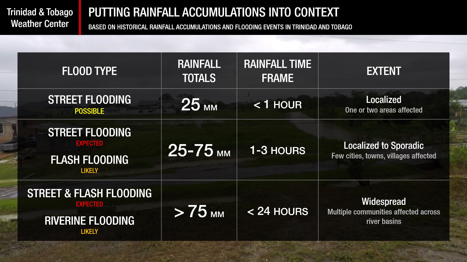
Understanding Rainfall Rates

Understanding Rainfall Accumulations
Putting the rainfall forecast into context, rainfall rates in excess of 50 millimeters per hour or areas that receive in excess of 25 millimeters within an hour tend to trigger street flooding across the country or flash flooding in northern Trinidad. For riverine flooding to occur, a large area of the country (not just in highly localized areas of western coastal Trinidad) would have to record upwards of 75 millimeters within 24 hours, and rainfall would have to fall across major rivers’ catchment areas.
Strong Thunderstorms
Strong ThunderstormsWhat is a strong or severe thunderstorm?
Given how rare these types of thunderstorms are in our region – we classify a severe or strong thunderstorm as one that produces any of the following:
- Damaging wind gusts exceeding 55 KM/H;
- Frequent lightning (more than 30 cloud-to-ground strikes within a 10-minute period);
- Hail (of any size);
- Rainfall of more than 50 millimeters or more within an hour or exceeding 75 millimeters or more within three hours;
- The sighting of a funnel cloud or touchdown of a waterspout/tornado associated with the thunderstorm.
Gusty Winds
Gusty WindsPossible impacts include localized wind damage to trees, power lines, and small structures, as well as fallen trees. Unsecured roofs may be blown off. Small potted plants may blow over with light outdoor objects, becoming airborne in stronger gusts. Tents may jump. Seas in sheltered areas will become agitated, and marine disruption is likely (on Thursday).
Other Hazards
Saharan Dust Forecast

Next Saharan Dust Surge Forecast By Mid-Next Week
Why I May Not/Will Not See Rainfall?
A frequent complaint is the forecast is wrong because I didn’t experience any rainfall. Scattered showers mean that you, individually, may experience some showers intermittently throughout the day, and there is a higher chance for this activity than isolated activity. Widespread showers mean that nearly all persons and areas may experience rainfall.
On Thursday, scattered rainfall is forecast, while on Friday and Saturday, isolated rainfall is forecast, becoming highly isolated thereafter.

Forecast Discussion
As forecast, Tropical Wave 49 is on T&T’s doorstep, knocking with showers and thunderstorms that are set to move across the Windward Islands today through tomorrow.
Forecast models continue to indicate much of the heaviest rains will remain north of Trinidad and Tobago, leaving western Trinidad in particular with mostly cloudy skies but little rains. Moderate to strong northerly shear is forecast to remain across T&T on Thursday into Friday, limiting persisting showers/thunderstorms. Still, mid and upper-level conditions are forecast to be quite favorable on Thursday through Friday morning, with peak favorability on Thursday afternoon to enhance convection (showers and thunderstorms). In heavy showers and thunderstorms on Thursday, gusty winds, heavy/violent rainfall, and lightning are likely.
Unsettled conditions are forecast to persist through the early afternoon on Friday as Tropical Wave 49 moves west, with trailing moisture and instability providing support for isolated showers and thunderstorms.
By late Friday into the weekend, a deep-layered ridge is forecast to rebuild across the region, including Trinidad and Tobago. Additionally, a surge of Saharan Dust is forecast to usher in a dusty and dry period across Trinidad and Tobago, which will also lead to rising daytime temperatures once again.
Particularly on Saturday, some pockets of low-level convergence and confluence will lead to the odd shower or even brief thunderstorm, but generally stable conditions are forecast into next week.
Tropical Wave 50, located along 33W on Wednesday night, is moving westward at about 15 knots but is forecast to slow down and stall in the central Main Development Region between the Lesser Antilles and the west coast of Africa. Its future is uncertain, as Tropical Wave 51 (yet to move off the African coast) is forecast to develop, entangling with Tropical Wave 50, which may mean that the wave never makes it to the Lesser Antilles as a separate entity. However, this wave will remain east of the region at least through the next 7 days, so we have several days (or even more than a week!) to monitor.


