The Trinidad and Tobago Meteorological Service (TTMS) is forecasting an above-average 2023 Atlantic Hurricane Season for Trinidad and Tobago. While systems may form within the TTMS area of interest, it only takes one storm to directly impact the country for it to be an active hurricane season for Trinidad and Tobago.
What you need to know
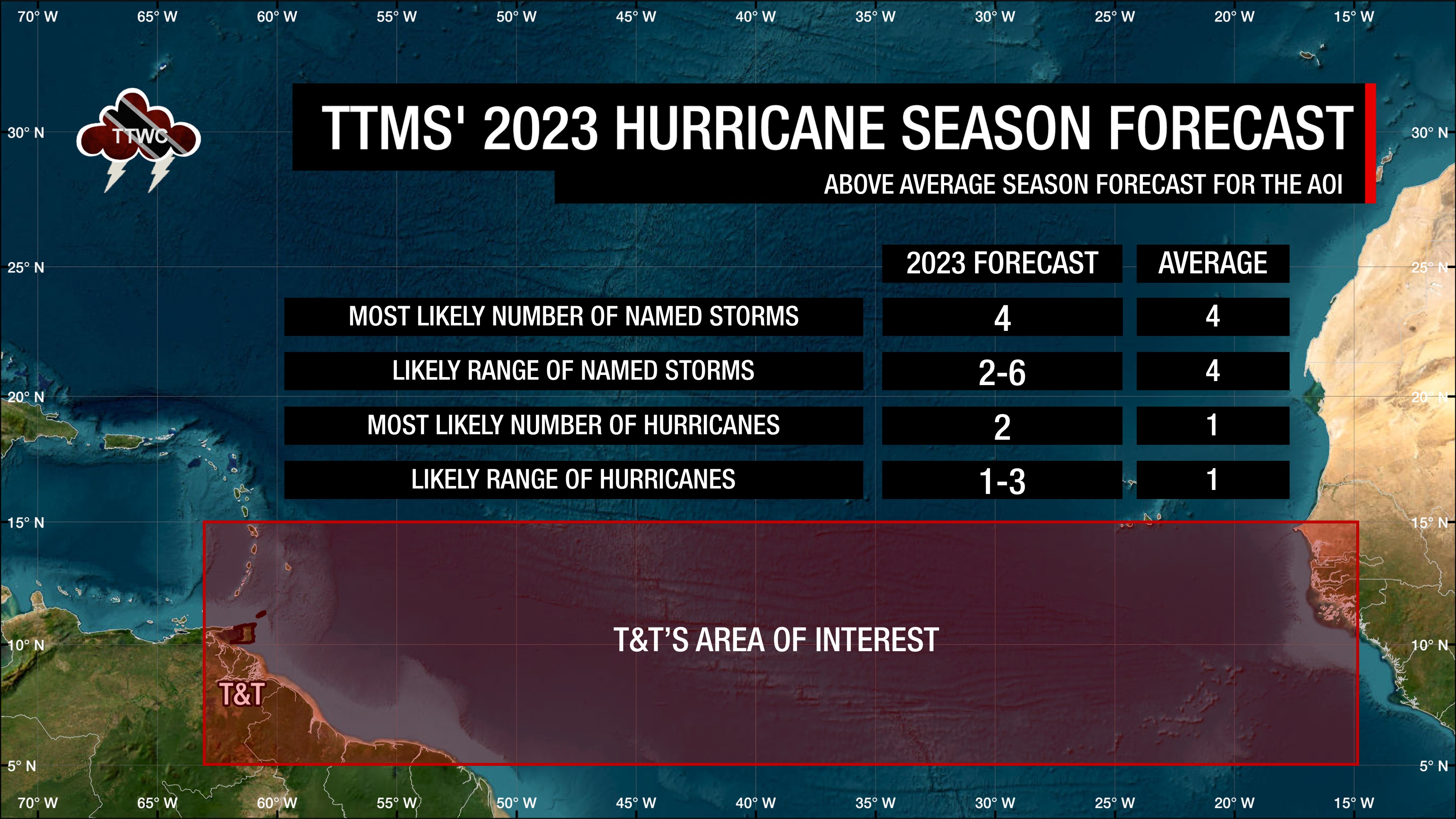
— The Forecast: Between the eastern Caribbean and the west coast of Africa, south of 15°N, the TTMS is forecasting between two to six named storms, with four named storms most likely forming and one to three of those becoming hurricanes, with two hurricanes most likely.
— How confident are they? The TTMS has a 34% chance of above-normal, 22% chance of below-normal, and 44% chance of near-normal activity.
— What should you do? Any tropical cyclone that forms in the area of interest has the potential to threaten Trinidad and Tobago and the remainder of the Eastern Caribbean. A season only needs one tropical cyclone to cause devastation in T&T and the remainder of the region. Citizens are advised to increase preparation ahead of the 2023 Atlantic Hurricane Season’s peak.
The Forecast Background
Since 2013, the Trinidad and Tobago Meteorological Service has been issuing seasonal forecasts for Trinidad and Tobago’s area of interest (AOI) for tropical cyclone activity.
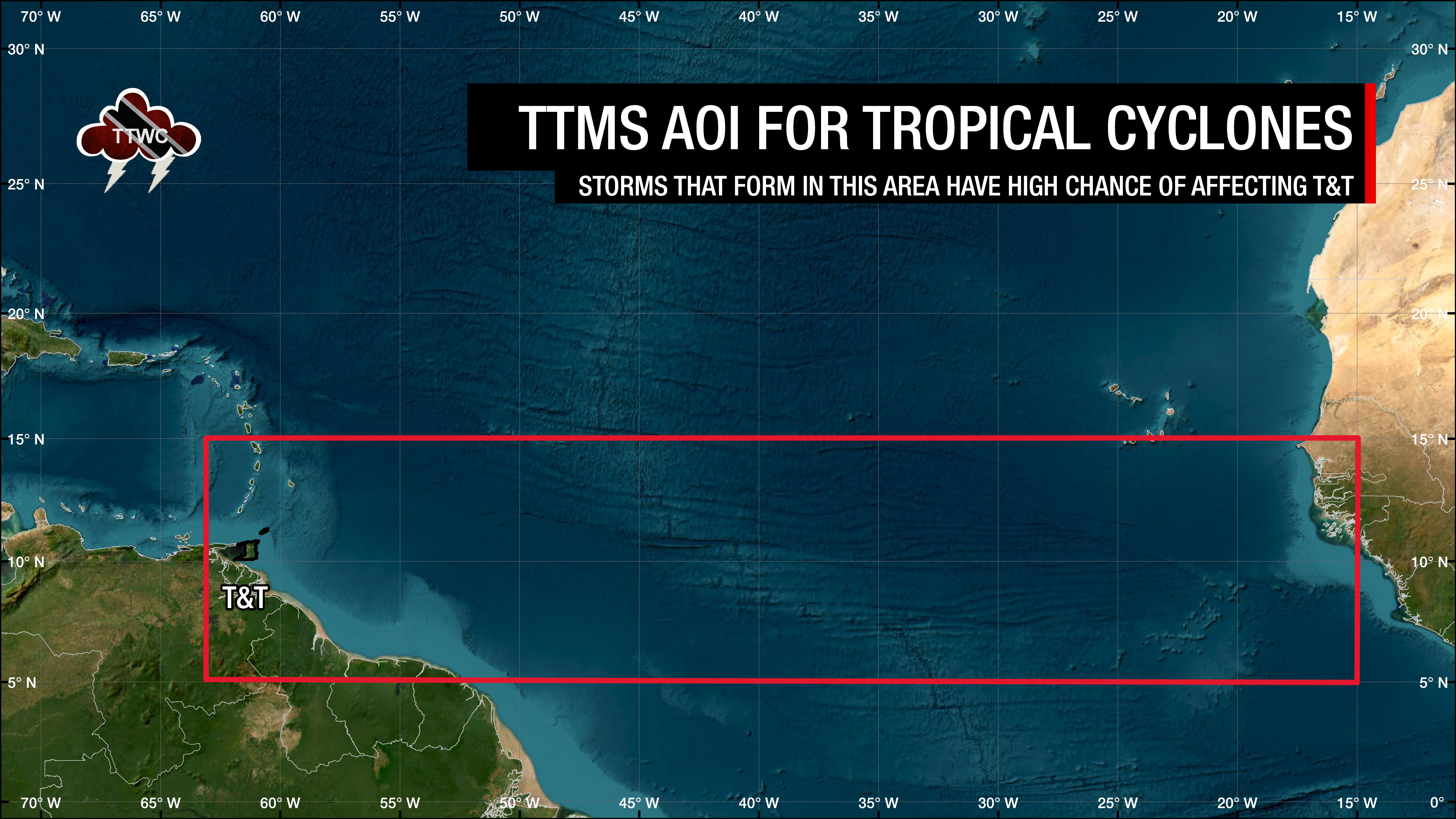
The Met Office has defined T&T’s AOI as south of 15°N latitude, between the eastern Caribbean and the west coast of Africa, within the north Atlantic Ocean. According to the Met Office, only tropical cyclones forming in this area have been known to directly threaten Trinidad and Tobago.
The North Atlantic Hurricane Season officially runs between June 1st through November 30th, but out-of-season systems have formed in the past, like January this year.
Based on the 1991-2020 climatological average, four named storms form in this area, with one becoming a hurricane.
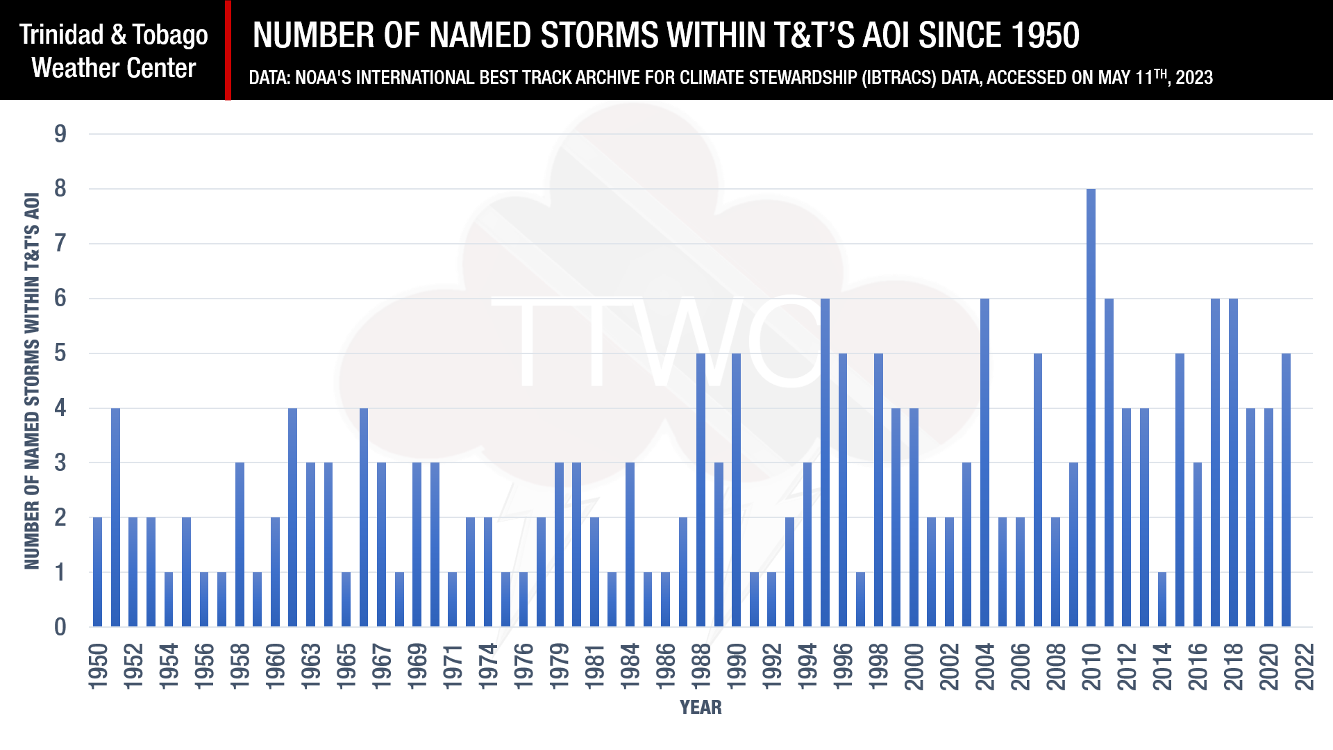
In 2022, the TTMS forecast called for four named storms as the most likely scenario, with two of these becoming a hurricane within the AOI. However, while Trinidad and Tobago was affected by three separate tropical disturbances that eventually formed Hurricane Bonnie, Hurricane Ian, and Hurricane Julia but none of these systems were named within the T&T’s AOI. The result – no named storms or hurricanes formed within the AOI.
The 2023 Hurricane Season Forecast For T&T
According to the Trinidad and Tobago Meteorological Service, there is a 34% chance of above-normal, 44% chance of near-normal, and 22% chance of below-normal tropical cyclone activity in the area of interest for T&T.
The TTMS is predicting that the most likely number of named tropical storms (tropical cyclones with winds of at least 34 knots, 39 MPH, or 63 KM/H) to occur within the AOI from June through November is four.
The most likely number of hurricanes (tropical cyclones with winds of at least 64 knots, 74 MPH, or 119 KM/H) predicted to occur within the AOI from June through November is two.
How does the forecast work?
According to the TTMS, the seasonal tropical cyclone predictions for T&T’s AOI are based on:
- Canonical Correlation Analysis and Principal Component Analysis to predict the number of storms based on sea-surface temperatures (SSTs) in oceanic regions, which are known to have strong correlations with tropical cyclone activity in the AOI;
- Analog years based on sea-surface temperature gradients.
The Met Office says their methodology considered three primary climate drivers in the form of SST gradients which are known to be responsible for annual tropical cyclone variability in the North Atlantic Ocean.
They explained that the three SST drivers of tropical cyclones are the El Niño-Southern Oscillation (ENSO), which is the known primary cause of variability in tropical cyclone activity in T&T’s AOI, the SSTs during March and April in the waters surrounding Trinidad and Tobago, which is that portion of the extension of the North Atlantic Warm Pool to the east and southeast of Trinidad and Tobago, and the SST gradients within the Atlantic Meridional Mode (AMM), which is north/south gradient in SSTs near the location of the mean Inter-Tropical Convergence Zone.
Current Conditions
Currently, SSTs east of Trinidad and Tobago to the west coast of Africa are above normal, with pockets of near-normal SSTs in and around the eastern Caribbean.
An El Niño Watch is in place for the eastern-central Pacific Ocean, with a moderate probability of an El Niño developing between May to July 2023. An El Niño will unfavorably influence rainfall and cloud development over T&T.
Furthermore, the north-south SST gradients, known as the Atlantic Meridional Mode (AMM), are currently in their positive mode and are likely to continue through the August-September-October period. A positive AMM is associated with enhanced ITCZ activity shifting further north and reducing upper-level westerly winds across the Atlantic Main Development Region
The North Atlantic Oscillation has alternated between phases since April 2023 and is forecast to move into the positive phase in June 2023, which results in increased trade winds across the Atlantic Ocean.
What does this mean for you?
Those that reside in Trinidad and Tobago know that it doesn’t take a tropical storm or hurricane to bring devastation to the country. In 2022, without a single direct hit from a tropical cyclone, the Caroni River overtopped five times within a month. Tobago experienced its wettest August on record, while Trinidad experienced its wettest November on record.
Though near to above-average tropical cyclone activity is forecast for T&T’s AOI, tropical waves, troughs, and the Intertropical Convergence Zone has been known to bring flooding rainfall to a highly flood-vulnerable country.
Use this dry transitionary month into the upcoming 2023 Wet Season to prepare your emergency kits, emergency plans and clean your surroundings. Know your emergency numbers in the event of a disaster, and for those living in a flood-prone area, know where you can readily access sandbags in the event of prolonged, heavy rainfall. The Office of Disaster Preparedness and Management also has a guide available to help prepare you for the upcoming Wet and Hurricane Season.