


Tropical Depression Thirteen has formed in the Central Main Development Region, midway between the Windward Islands and the African Coast. Forecast models and the National Hurricane Center (NHC) show significant development of this system over the next several days, keeping the potentially powerful tropical cyclone north of the Lesser Antilles, based on model runs and the latest forecast on Tuesday morning.
Based on the projected path, this system is forecast to spare most of the Lesser Antilles from significant winds and rains but will bring weakened winds, increased temperatures, and potentially hazardous seas to the region.
What you need to know
— What has happened: A robust tropical wave, designated as Invest 95L, has formed into Tropical Depression Thirteen well east of the Lesser Antilles. The National Hurricane Center is forecasting the system to become a strong tropical cyclone in the coming days.
— Where is it forecast to move: Forecast models and the NHC show the eventual hurricane remaining north of the Lesser Antilles, but given the forecast strength and size of the wind field, gusty winds and outer bands may affect the Leewards.
— The Intensity & Impacts: Forecast models indicate this tropical storm has the potential to become a powerful hurricane, remaining north of the Lesser Antilles. While feeder band activity can’t be ruled out at this time for the Leewards, for the remainder of the Lesser Antilles, mostly hot and sunny conditions are expected. Isolated daytime showers and thunderstorms, favoring the western halves of the islands, are possible from Friday, with agitated seas likely, particularly for the northern half of the island chain.
— Latest from officials: Across the island chain, there are no alerts, watches, or warnings. However, several meteorological offices, like Antigua and Barbuda, Trinidad and Tobago, and Barbados, have issued statements on the system.
The latest
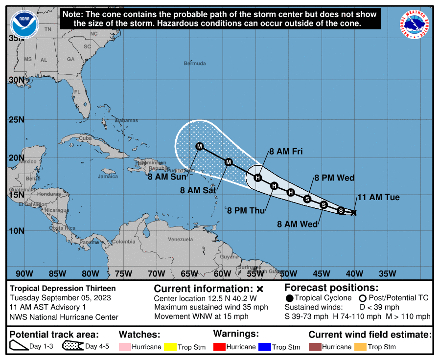
At 11:00 AM Tuesday, September 5th, 2023, the approximate center of Tropical Depression Thirteen was located at 12.5N, 40.2°W, placing it approximately 2,295 kilometers east of the Lesser Antilles and Trinidad and Tobago.
According to the NHC’s 11:00 AM Advisory, the depression is moving toward the west-northwest near 24 KM/H, and this motion is expected to continue for the next few days.
Maximum sustained winds are near 55 KM/H with higher gusts. The depression is forecast to be a hurricane in a couple of days and could become a major hurricane in a few days, according to the NHC.
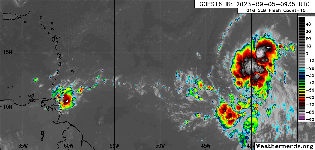
This disturbance is producing widespread cloudiness with scattered showers and thunderstorms. It is located in a pocket of favorable upper-level divergence, low-level convergence, and a narrow area of light to moderate wind shear. Sea surface temperatures are between 29°C and 30°C with anomalously high atmospheric moisture.
Where is it going?

Forecast models show Tropical Depression Thirteen being steered west-northwest over the next several days by a subtropical mid-level ridge anchored in the North Atlantic Ocean, taking the system generally north of the Leeward Islands, but it is still too early to determine exactly how close this system will get to the Leeward Islands, according to the NHC.
Over the last 24 hours, now Tropical Depression Thirteen has maintained a generally west to west-northwestward path, but once this system consolidates, as with most tropical cyclones east of the Lesser Antilles, it will continue its west-northwest path as it strengthens.
As it stands on Tuesday morning, Tropical Depression Thirteen and the eventual tropical storm/hurricane is no direct threat to Trinidad and Tobago. While forecast models keep this low-pressure system north of the Leewards, interest there should pay close attention to forecasts over the next five days as it nears the area.

How strong could it get?
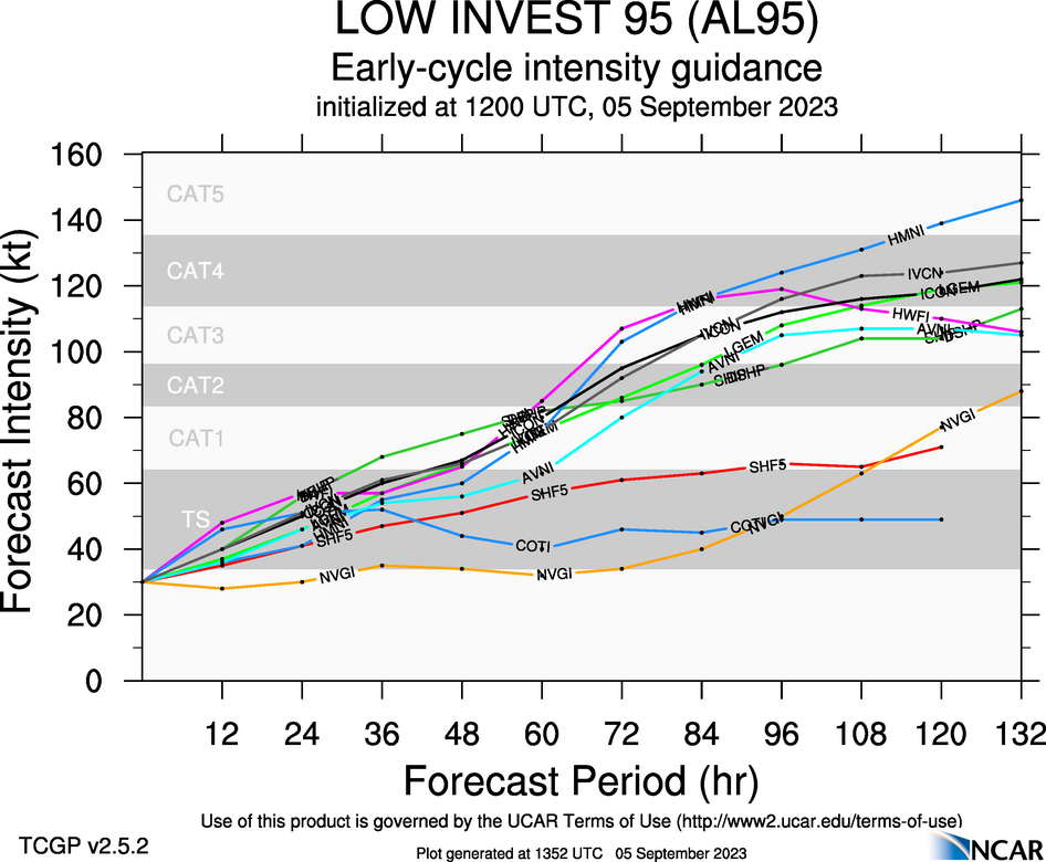
Based on the current forecast tracks, models move Tropical Depression Thirteen through an extremely favorable environment. With an upper-level high above the eventual tropical cyclone, with subtropical jet streams allowing for the storm to be ventilated (outflow leading to favorable upper-level conditions, light to moderate northeasterly vertical wind shear, high sea-surface temperatures analogous with the Gulf of Mexico and record warmth for the Atlantic, and a relatively moist environment, leading forecast models and their ensembles and the official NHC forecast show Tropical Depression Thirteen becoming a hurricane in 48 hours and a potential major hurricane in 72 hours.
According to the National Hurricane Center’s 2022 verification report, the consensus models IVCN and HCCA were the best aids overall, while the HWFL was the best individual model. For Tropical Depression Thirteen, these models have continuously shown a strengthening tropical cyclone into a major hurricane by Friday night into Saturday.
What does this mean for the Lesser Antilles?
Given the potential for a higher-end hurricane in the vicinity of the Leewards, interests in the Northern Lesser Antilles should pay close attention to official forecasts in the coming days as this eventual system is forecast to track in that vicinity by Friday night through the weekend. In addition, the close proximity to the eventual system may result in feeder band activity moving across the northernmost Leewards.
For the remainder of the Lesser Antilles, the main hazards from Friday into the weekend will be localized, heat-driven, heavy showers/thunderstorms along western and northern areas of islands, and potentially hazardous seas, particularly for the northern half of the island chain. For the southern half of the region, including T&T, stronger southeasterly winds are likely on Saturday, which may make it to the surface.
Wind

Based on the latest guidance, tropical-storm-force wind gusts and sustained winds (above 34 knots, 39 MPH, 63 KM/H) are forecast to remain north of the northernmost Leewards, but islands north of Guadeloupe and east of Puerto Rico are forecast to experience wind gusts in heavy showers/thunderstorms between 40 and 60 MPH (64 to 97 KM/H). However, this is dependent on how close the core of the eventual system moves to the Leewards.
For the central Lesser Antilles, a low-level to surface trough extending southwestward from the eventual low-pressure system will create slack to near-calm winds, leading to hot daytime temperatures and isolated late-morning through afternoon showers/thunderstorms along western and hilly areas.
For the southern Lesser Antilles, including T&T, the pressure gradient between the low-pressure system north of the Lesser Antilles and a high-pressure system over northern South America will lead to strong low-level southeasterly winds across the area from Saturday (the peak) through Monday, which can make it to the surface in showers or thunderstorms. Wind gusts exceeding 45 KM/H are likely during this period.
Rainfall

The highest rainfall accumulations are forecast to occur across the northernmost Leewards, with rainfall totals through Monday, September 11th, 2023, ranging between 25 and 50 millimeters (1-2 inches) with isolated totals up to 100 millimeters (4 inches) based on the current forecast track.
For the central Lesser Antilles, rainfall totals are forecast to be less than 25 millimeters (1 inch).
For Trinidad and Tobago, rainfall totals during this period are also forecast to be less than 25 millimeters (1 inch), with isolated totals up to 50 millimeters (2 inches).
Seas and Storm Surge

Forecast models are showing waves in open waters are forecast to exceed 3.0 meters (9 feet) and up to 4.0 meters (12 feet) near east and north-facing coastlines from Guadeloupe to Anguilla. From Dominica to Barbados, inclusive of St. Vincent and the Grenadines, open water waves can reach as high as 2.5 meters (8 feet). For T&T, seas are forecast to remain moderate, with open waters waves occasionally up to 2.0 meters this weekend into early next week.
Again, this is based on current track and intensity guidance, which can change in the coming days.
For Trinidad and Tobago
Latest Forecast

Forecast: Isolated Showers, Thunderstorms Ahead of Significant Saharan Dust Surge
Trinidad and Tobago is NOT under any tropical storm or hurricane threat, watch, or warning at this time.
Pay close attention to official forecasts in the coming hours and days from your respective authorities. For Trinidad and Tobago, official forecasts and early warnings come from the Trinidad and Tobago Meteorological Service.


