Tropical waves are beginning to roll off the African Coast, which is expected for May.
With these early-season tropical waves, showers and thunderstorms tend to be quite spare, and the wind shifts associated with them are quite weak. This trend continues in the case of the first two tropical waves for 2023.
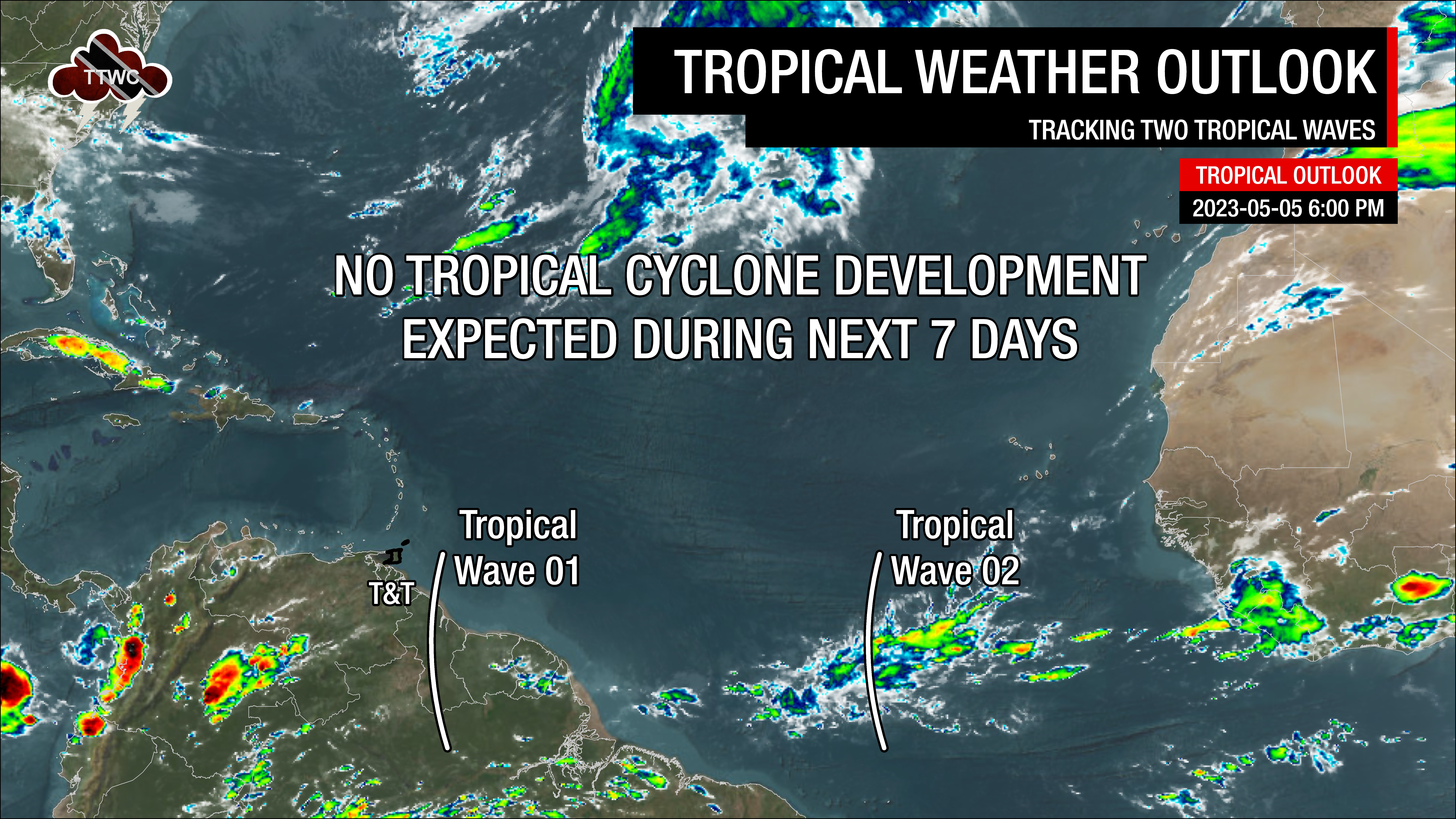
The result – no major rainfall or severe weather for Trinidad and Tobago is in the forecast.
What you need to know
— Tropical Wave 01: The axis of this tropical wave is poorly defined, with the overall wave very weak. On Friday evening, it is located along 57W, moving west at 15 knots (27 KM/H). It is forecast to move across Trinidad and Tobago later on Saturday, May 6th, 2023. No major rainfall is forecast. If rain is recorded at Piarco International Airport and the A.N.R. Robinson International Airport, the 2023 Wet Season will be triggered.
— Tropical Wave 02: The axis of this tropical wave is located along 37W, moving west at 15 knots to 20 knots (27-37 KM/H). Scattered showers have been noted on either side of the wave axis, particularly where the wave interacts with the ITCZ. The wave is forecast to remain mostly south of the Lesser Antilles, with the northern portion of the axis moving across T&T and Grenada on Monday night into Tuesday.
— Hazards: With a mostly dry and hostile atmosphere forecast, no major rainfall or severe weather is forecast across Trinidad and Tobago with either of these waves. On Tuesday, following the passage of Tropical Wave 02, a surge in easterly winds is forecast. Sustained winds could reach as high as 35 KM/H with gusts to 50 KM/H.
— Development Concerns: Tropical cyclone development is not forecast over the next seven days. The National Hurricane Center will issue the first official Tropical Weather Outlook on May 15th.
Tropical Wave 01
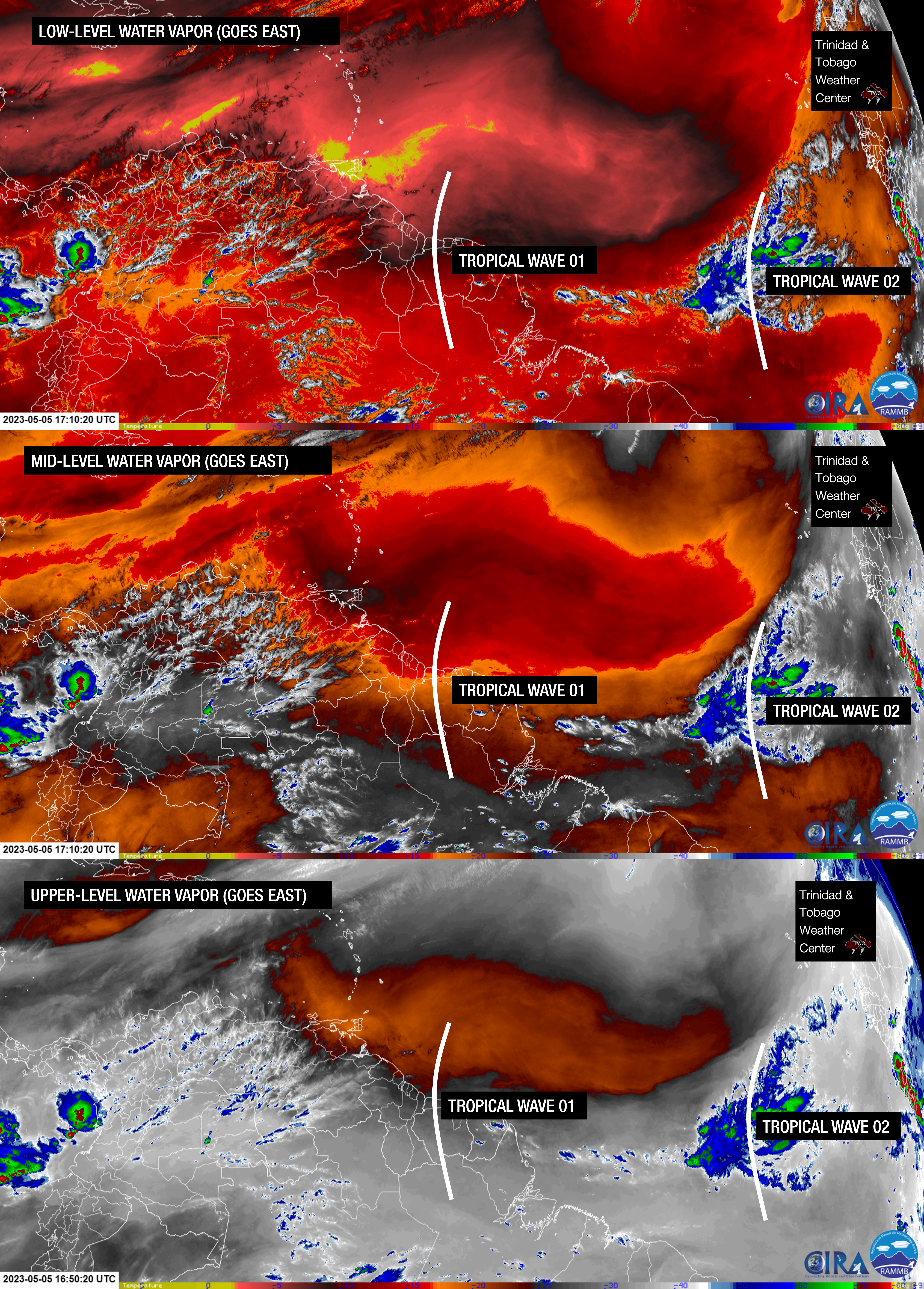
The first tropical wave analyzed by the Trinidad and Tobago Meteorological Service moved off the African Coast on April 30th, 2023. While convection pulsed with this wave as it moved across the Atlantic, it was poorly defined on its trek towards Trinidad and Tobago at the surface.
Tropical waves’ signature is best seen at the 700-millibar level, approximately three kilometers above ground. Outside of this 700-millibar signature of a wind shift, a vorticity maximum, and a minimal increase in atmospheric moisture, few surface features exist. This tropical wave has been moving westward at approximately 15 knots (28 KM/H). Based on its current trajectory, it is forecast to predominantly move south of Tobago, with the northern axis of the wave potentially moving across Trinidad on Saturday evening.
A weak vorticity maximum at the 700-millibar level is located along 57W as of 5:00 PM, Friday, May 5th, 2023, indicative of the location of the wave. There is little to no convection associated with the wave, with a marginal increase in total precipitable water (TPW).
Across the wave axis, TPW values are near 1.33 inches, with relative humidity between 300mb to 850mb, around 24%, indicative of a very, very dry atmosphere. Wind shear is roaring across the Lesser Antilles, with speeds up to 50 knots. Combined with an upper-level convergent pattern, these factors are forecast to limit rainfall across Trinidad, Tobago, and the southern Windwards as this weak tropical wave moves across the area.
Following the passage of this wave on Saturday evening, an increase in partly cloudy periods is forecast. Winds will be veering through the atmosphere, meaning winds will be turning clockwise as it increases in height through the atmosphere. This veering wind and a marginal increase in moisture could support a weak thunderstorm or a localized heavy shower Saturday night through Sunday, favoring southern coastal Trinidad.
Notably, this tropical wave has only been analyzed by the Trinidad and Tobago Meteorological Service and us at TTWC. It was not analyzed by the U.S. National Hurricane Center’s Tropical Analysis and Forecast Branch, the U.S. National Weather Service International Desks (though it was analyzed as an easterly wave), the Barbados Meteorological Service, and the Brazilian Navy, which produces synoptic maps for the Atlantic. This wave has had clear African origins and the relevant criteria for a tropical wave based on international definitions.
Tropical Wave 02
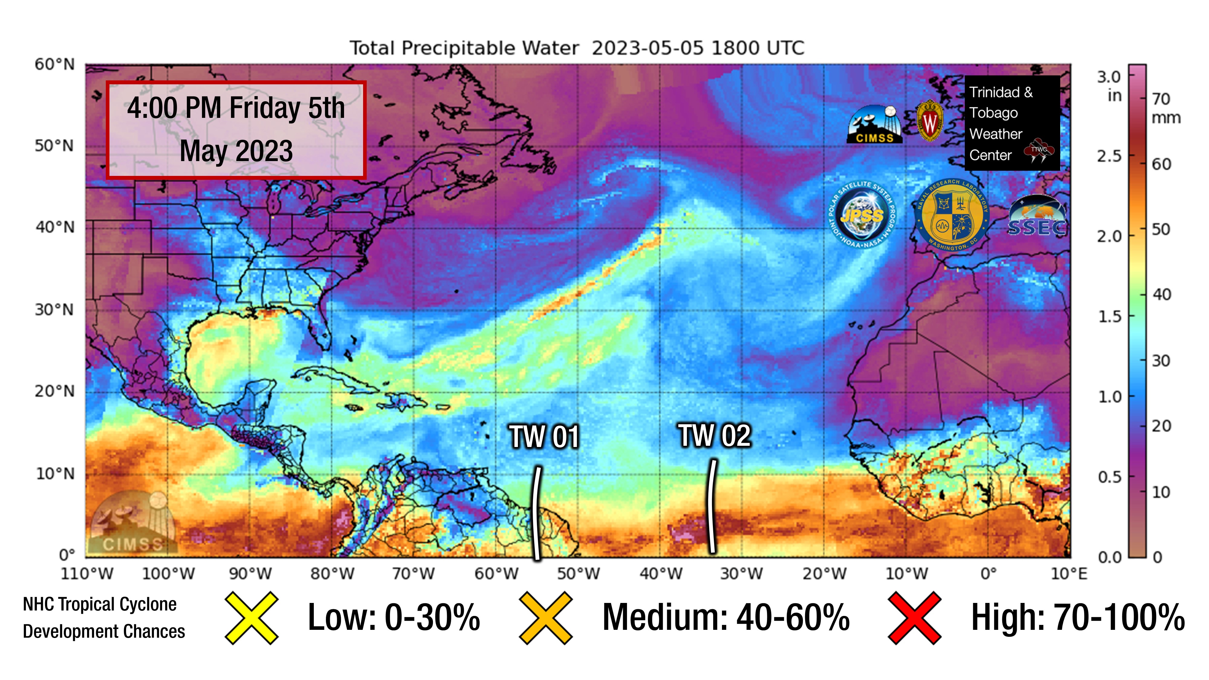
The second tropical wave for 2023 left the African coast on May 2nd, with pulsing convection as it moved into the central Main Development Region of the tropical Atlantic, interacting with the Intertropical Convergence Zone. As of 5:00 PM, the axis of this tropical wave is located along 37W, moving west at 15 knots to 20 knots (27-37 KM/H).
Based on its current trajectory, the axis of this wave is forecast to move across the southern Windwards and northern South America overnight Monday, May 8th, 2023, into Tuesday, May 9th, 2023.
Forecast models disagree on moisture levels as the wave axis moves across Trinidad and Tobago. The ECMWF shows a modest level of low-level moisture during the passage, while the GFS shows a very dry atmosphere persisting across the area. Regardless, both top models show little significant rainfall accumulating across the country.
However, following the passage of the wave axis, a surge in low-level winds is set to follow, with wind speeds reaching as high as 35 KM/H and gusts as high as 50 KM/H possible, particularly across eastern and elevated areas and in the vicinity of the showers.
This tropical wave has been analyzed by the Trinidad and Tobago Meteorological Service, us at TTWC, the U.S. National Weather Service International Desks, and the Barbados Meteorological Service. It was not analyzed by the U.S. National Hurricane Center’s Tropical Analysis and Forecast Branch.
Not Every Tropical Wave Brings Severe Weather
Tropical waves vary in intensity as it travels westward across the Atlantic. This variability can be on the order of days to as short term as hours. Sometimes, you may see satellite imagery that shows heavy thunderstorms and deep convective activity east of Trinidad and Tobago during the late night and early morning, but by daybreak – nothing.
This is due to diurnal (daily) variations in convective showers whereby convection peaks overnight and wanes during the day for already occurring convective systems (i.e., not triggered by daytime heating).
Activity can be enhanced by its proximity to upper-level troughs and the ITCZ but can also be degraded by hostile upper-level conditions and Saharan Dust.