


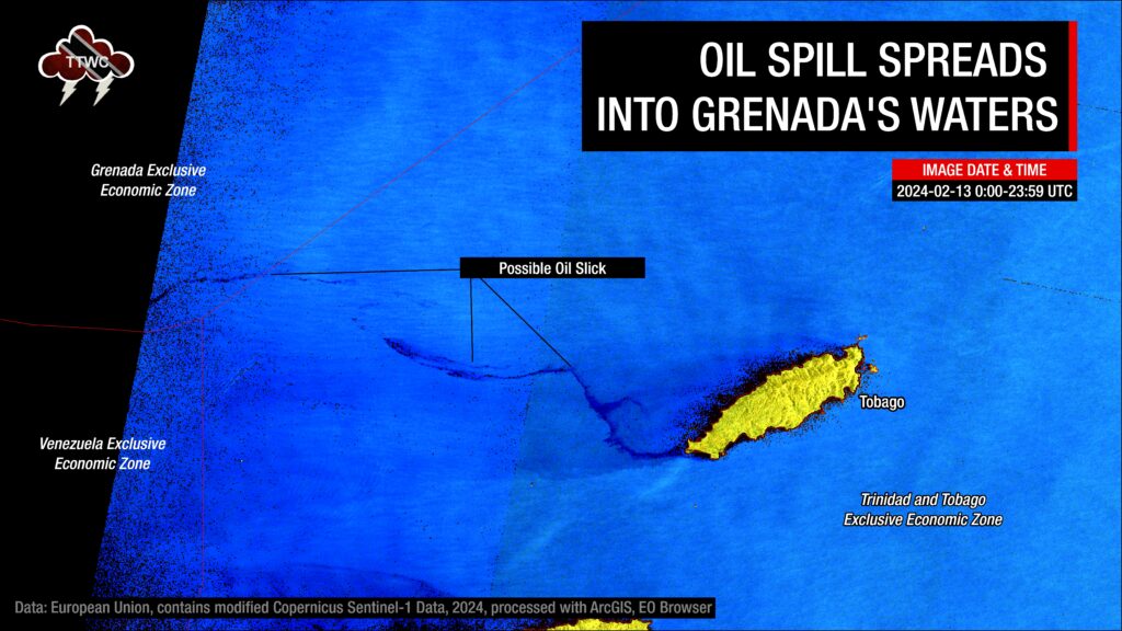
The latest satellite imagery by Copernicus Sentinel-2 and Canadian RCM has detected possible oil moving out of Trinidad and Tobago’s marine area, through Grenada’s southernmost marine area of responsibility and into Venezeuala’s marine area, north of Los Testigos Islands.

The Los Testigos Islands are located about 400 km (250 mi) northeast of Caracas and about 80 km (50 mi) northeast of Isla Margarita. The population is about 200 inhabitants (according to the 2001 census), mostly fishing families.
Based on data analyzed by TTWC and the Tobago Emergency Management Agency (TEMA), vividly showcases a silver-like slick and streaks of a thick, black-like substance. The anomaly now extends 150 nautical miles northwest from the westernmost point of Tobago, reaching areas north of The Los Testigos Islands, north of Venezuela, and south of Grenada.
Samples have been sent to the Institute of Marine Affairs for fingerprinting. Once the samples are run, the type of substance can be identified. In the past, crude oil has been misidentified as bunker fuel or another type of hydrocarbon. To ensure accuracy in reporting, until the samples are confirmed to be crude oil (or otherwise), we will continue to use “oil-like substance” in our reporting. TEMA estimates the IMA report should come in sometime this upcoming week.
The oil-like substance has been spilling into the ocean since sometime from February 4th to 5th, initially covering the windward coastlines of Tobago, closest to where the barge was stuck on Cove Reef from February 7th. On Sunday, February 11th, 2024, the oil-like substance traveled up to 88 kilometers west and northwest of Tobago, and by February 14th, the oil slick measured 78 nautical miles, approximately 144 kilometers in length, and extended from the west to northwest of Tobago, into the Caribbean Sea.
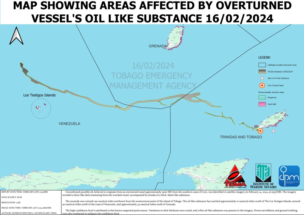
This spill has now extended well outside of Trinidad and Tobago’s Economic Exclusive Zone (EEZ), which is the of the sea in which T&T has exclusive rights regarding the exploration and use of marine resources, including energy production from water and wind.
The possible oil slick has moved through the southernmost area of Grenada’s Economic Exclusive Zone.
On Friday, February 16th, 2024, the Caribbean Disaster Management Agency (CDEMA) held a meeting with stakeholders across the southern Windwards, including T&T. According to CEO of TEMA, Allan Stewart: “I can report, based on what was said at the meeting, that they (CDEMA, Grenada) have activated their plan to cope with what is coming that may probably come their way based on those projections there. There is a probability. I will not give the level of that probability now, I will leave that for the other technical people to do, but that they may be missed.” Stewart added, “Definitely the southern part of it (Grenada), if it’s going to impact, certainly it will be the southern tip of Grenada which, as you know, St. George’s that is a southern part of the of the island.”
TEMA also added their collaboration with the Institute of Marine Affairs and the Office of Disaster Preparedness and Management yields a high confidence level attributed to the known suspected point source. Notable variations in slick thickness were observed, and a thin oil-like substance was evident in the imagery.
On Wednesday, February 14th, 2024, one week after the Tobago Oil Spill began, the Trinidad and Tobago Coast Guard made headway in learning new information about the vessel’s origins.


