In a cruel repeat of history, Tobago is facing another oil spill-related environmental disaster 44 years after the fifth-largest oil spill on record occurred 18 kilometers east of the island. This latest spill, however, is still shrouded in mystery nearly five days after a thick, black oil-like substance began to wash up on Tobago’s shores. There have been no reports of injuries or fatalities as a result of the overturned ship or subsequent spill at this time.
What you need to know
— The ship & leak: The details of the ship and the circumstances surrounding the wreck are still not clear. After divers identified the name of the ship as Gulfstream on Thursday, attempts to further explore the wreck to ascertain the vessel’s registration number have been unsuccessful due to poor visibility and the ship’s frequent movement in shallow water. Expert divers on Saturday, according to one media report, said plugging the leak may be impossible. Samples have been sent to the Institute of Marine Affairs to fingerprint the oil-like substance, with the report expected sometime this upcoming week.
— Who and where is affected: Nearly 45 kilometers of combined coastline and near-shore marine areas, spanning from south of Belle Garden to the southern end of Crown Point. have recorded the oil-like substance from Gulfstream.
— The response so far: The Tobago House of Assembly, in conjunction with the Tobago Emergency Management Agency, have been spearheading efforts both onshore and in collaboration with T&T’s central government agencies and multiple other entities to clean affected areas through manual removal of oil-soaked sargassum peat moss, and booms that both control and absorb the oil-like substance. Divers have been investigating the ship. Prime Minister Dr Keith Rowley is set to tour the affected areas today, Sunday.
What we know about the ship

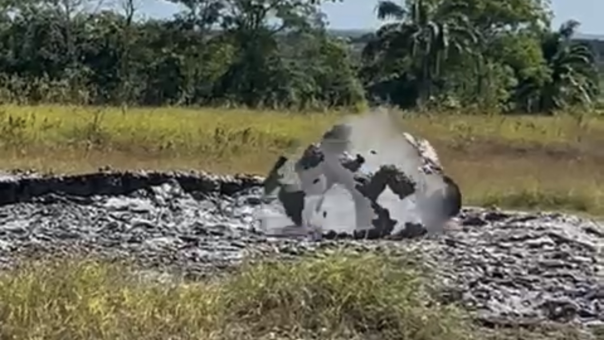
At 7:20 AM Wednesday, February 7th, 2024, the Tobago Emergency Management Agency (TEMA) received a report of a capsized ship approximately 150 to 200 meters south of Cove, Tobago, with a thick, oil-like substance washing up on nearby coastlines and spreading across Tobago’s windward coastal waters. The North Post Radio did not receive distress calls from the vessel.
It is still unclear where the ship overturned and whether there were any souls aboard at the time of capsizing. On Wednesday, the Tobago House of Assembly (THA) engaged local certified divers to conduct a rescue/recovery effort to investigate whether any individuals were trapped under the boat and ascertain the vessel’s name. By Wednesday night, divers were able to identify the 330-foot (100-meter) vessel as “Gulfstream”, and there were no visible signs of human life or remains. Repeat dives to the vessel proved challenging to get the International Maritime Organization (IMO) registration number due to poor visibility and the vessel constantly moving.
In their preliminary assessment, TEMA said, “It has been determined that the vessel may have been carrying lumber and sand,” but no lumber has washed up on any shore to date. However, the exact spot where the ship overturned is also still unclear.
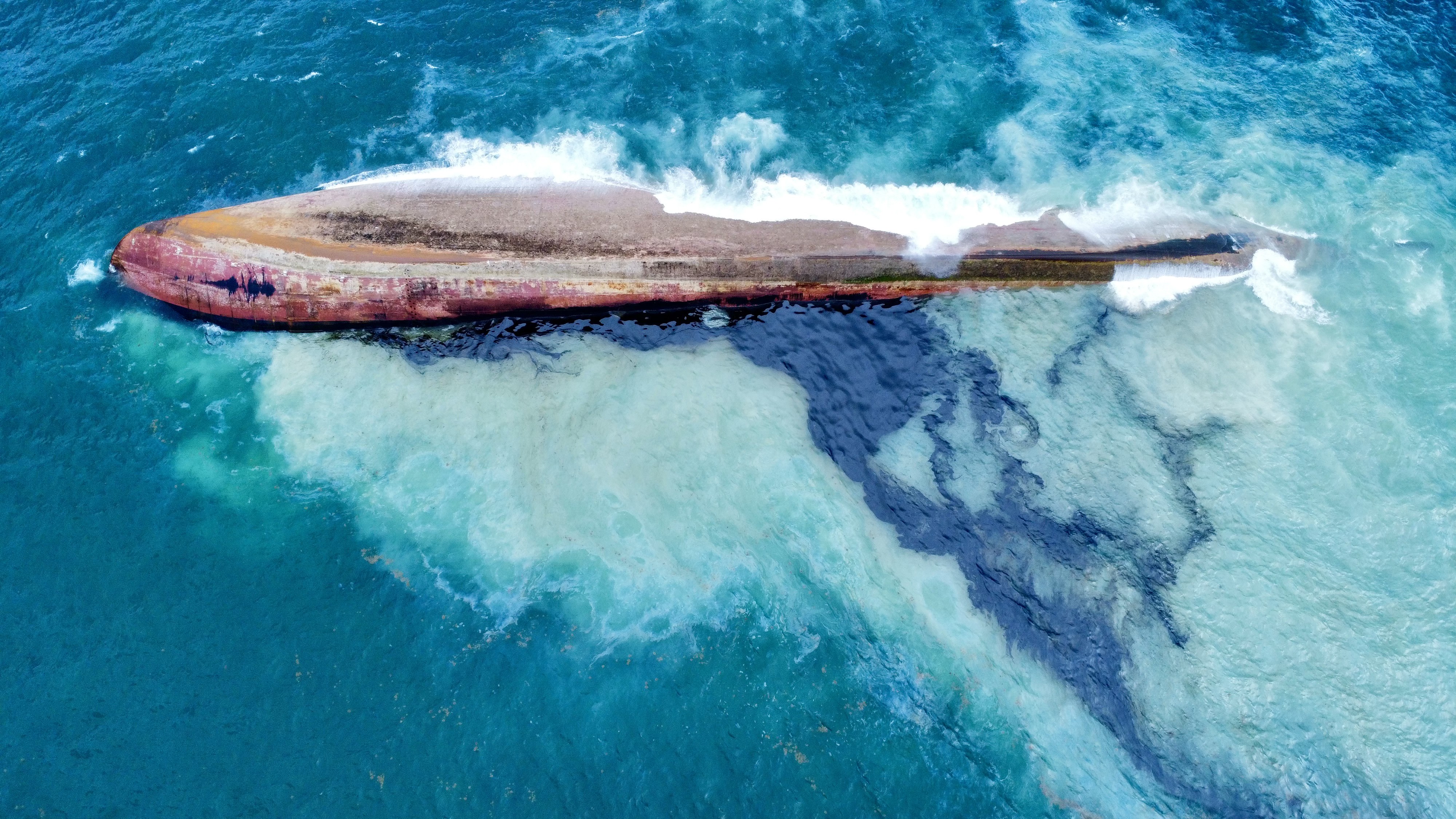
Divers returned on Thursday and Friday to inspect the overturned vessel. Lead Diver Alvin Douglas explained that the vessel was lying in 20 to 25 feet of water, the bow (front of the ship) in 25 feet of water at the edge of the reef, and the stern (back of the ship) in approximately 40 feet of water. He added, “It has moved somewhat; it’s actually in shallower waters because the prevailing currents and the wind are constantly pushing that vessel towards the shoreline.”

In their dive on Friday, the team made some new discoveries. Douglas said, “We also observe that there is a debris trail on the water that suggests that the vessel was turned over even before it made contact with the reef. The superstructure of the vessel was torn off. There were cranes, arms and railings all the way, and there’s a lot of destruction in that area.”
He also added, “We also found a cable that is connected to the bow of the vessel. That also suggests that the vessel may have been in tow because the anchor is secured where it’s at. But there is a huge tow line, approximately a third of the length of the vessel.”
The dive team also noted that the vessel was being pushed into the reef and still leaking the oil-like substance.
The leaking oil-like substance
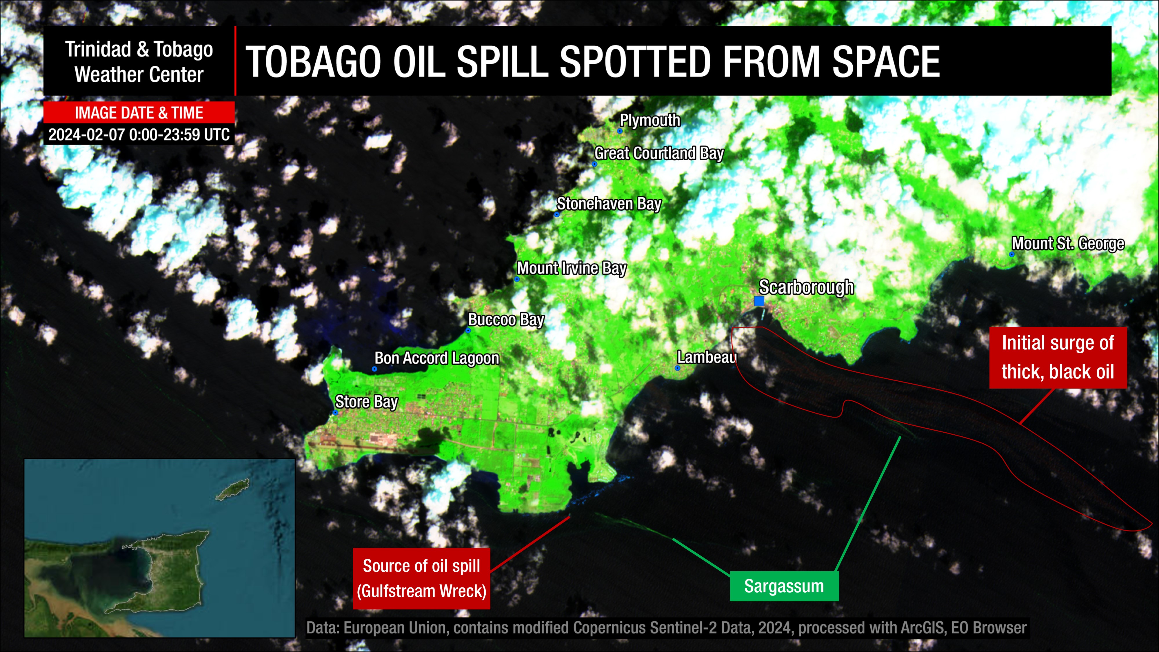
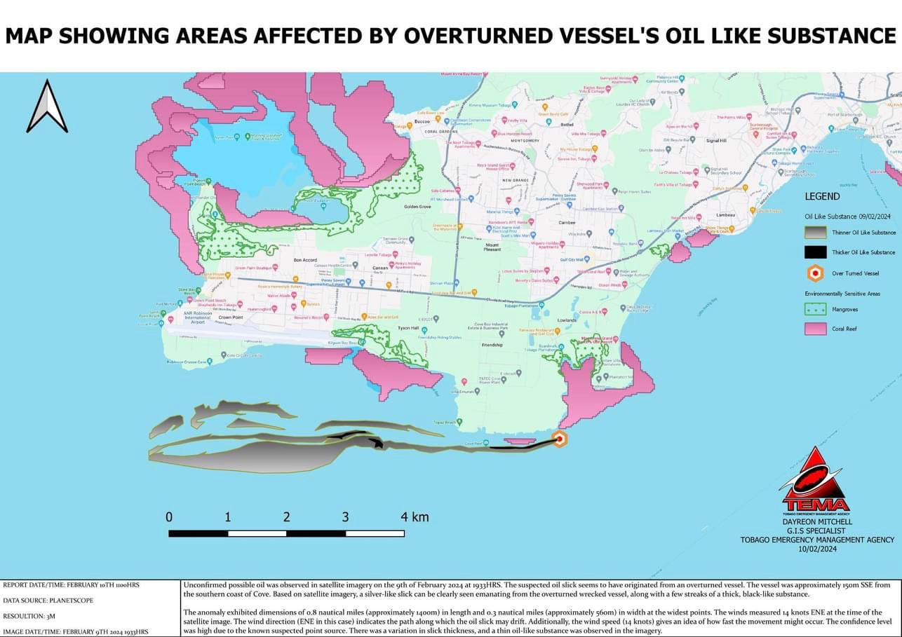
From Wednesday morning, the oil-like substance began washing up at Canoe Bay, extending to the Port of Scarborough. Moderate to strong southwesterly to southeasterly winds on February 7th pushed a 12 to 15-kilometer-length area of oil towards Scarborough and areas further north, which was captured on a very fortunate Sentinel-2 pass. This satellite data gave TEMA needed data, as the T&T Air Guard was unable to provide aerial support at the time.
Dayreon Mitchell, a TEMA GIS Specialist, has been using this data to support the response operations in Tobago. According to the data and observations, oil from this initial surge would have moved onshore in the vicinity of The Esplanade, Scarborough, towards Kilgwyn Bay, near Crown Point and the A.N.R. Robinson International Airport, spanning approximately 15 kilometers.
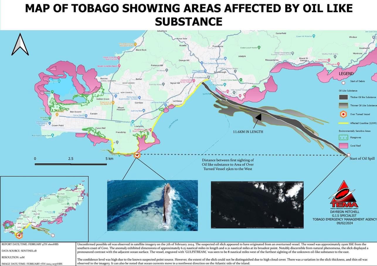
According to Mitchell, within this area, “We have some eco-sensitive areas along that [coast]line, including Kilgwyn Bay, the Magdalena Petit Trou, and the Lambeau Beach area. There are a lot of reefs along that site.
By Saturday, February 10th, 2024, prevailing winds are now mostly easterly, resulting in the oil-like substance, which continues to freely flow into the ocean, now moving to the west, toward Crown Point.
According to a recent report on Saturday night, lead diver Alvin Douglas told Guardian Media that the specialist divers from the Institute of Marine Affairs have found it impossible to plug the spill. He said the team will now have to re-strategize. “The spill has not been contained. What is happening is, from the professional commercial divers’ point of view, the vessel is in a peculiar area. It cannot be entirely contained. The boat keeps bobbing up and down. We did our best to contain as much as we can. With regard to plugging it, that may not be possible.”
Officials are still awaiting to acquire the formal details of the vessel to ascertain the type of vessel and maximum capacity of the ship, which will give an estimate of the potential worst-case discharge of the oil-like substance. On Sunday, the THA will be utilizing unmanned submarine vehicles with cameras to investigate the vessel and retrieve the necessary information.
Samples have been sent to the Institute of Marine Affairs for fingerprinting. Once the samples are run, the type of substance can be identified. In the past, crude oil has been misidentified as bunker fuel or another type of hydrocarbon. To ensure accuracy in reporting, until the samples are confirmed to be crude oil (or otherwise), we will continue to use “oil-like substance” in our reporting. TEMA estimates the IMA report should come in sometime this upcoming week.
The fallout in Tobago
Tobago’s economy is highly dependent on tourism, and its fisheries play a substantial part in the overall food security – both of which are now significantly affected.
From the first day of the spill, the THA strongly advised fisherfolk and beachgoers to avoid the coast between Rockley Bay to Canoe Bay. THA Chief Secretary Farley Augustine said, “Let me warn fisherfolk, those with vessels, those with jet skis, swimmers, whomever, please avoid the area as much as possible. Don’t go purposefully sightseeing and sailing into the area. It’s not an opportunity to go sightseeing isn’t an opportunity to go being more cautious. Please be cautious and avoid the area.”
Augustine also warned fisherfolk of plying their trade in the area, going as far as saying, “I wouldn’t want to raise the alarm to the extent of saying that people should not buy fish around the island because it’s not safe to eat. That’s not necessarily the case. Just avoid that area. And I assure you that most of our fisherfolk are responsible members of the industry, they will not go fishing in the midst of the oil spill, they will go distances much further away.” Many fisherfolk expressed concern for their livelihoods, but Augustine said until the vessel and its owner can be identified, only then can the conversation occur because there is still the question of liability.
The Junior Parade of the Bands on Sunday, February 11th, 2024, was cancelled as a precaution for health and safety, while some businesses in Scarborough reportedly closed on Thursday.
The Response
In the first few hours of the report of a capsized vessel and leaking of an oil-like substance, the THA engaged private divers to investigate the vessel for its identity, as well as rescue and recovery for any people that may have still been aboard.
The THA had meetings with TEMA and the Ministry of Energy and Energy Industries, which is the custodian of the National Oil Spill Contingency Plan and leads the Incident Command Team in the event of a major spill, and Kaizen Environmental Services, a company that specialises in oil spills. Kaizen allowed the THA to use their equipment to mitigate against further environmental damage, as it was already stored in Scarborough in the event of an oil spill. TEMA also had peat moss in stock, which can be used to encapsulate the oil-like substance for safe disposal.
In the first media conference concerning the spill, the THA Chief Secretary said while the T&T Coast Guard has been involved and is involved in efforts, Augustine alluded to their slow response due to the Coast Guard’s limitations in their Tobago operations. He explained that the T&T Coast Guard then was leading the marine response while the Division of Natural Resources and the Environment was leading the onshore response.
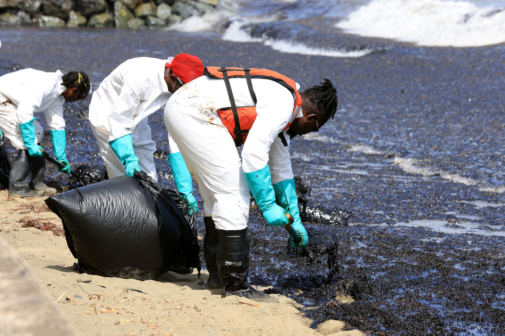
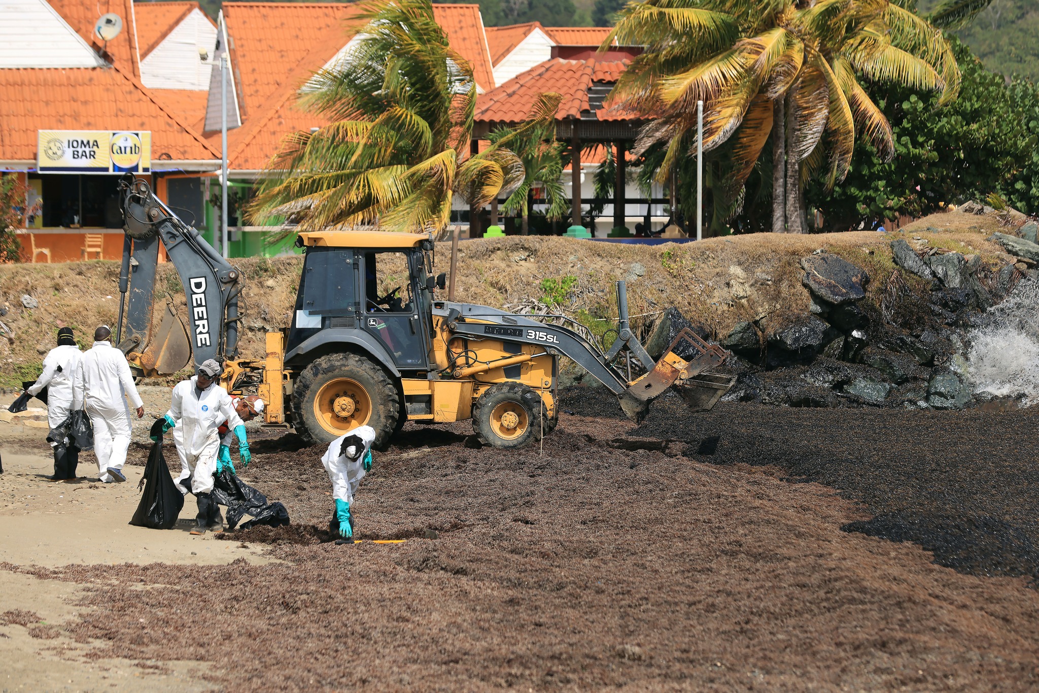
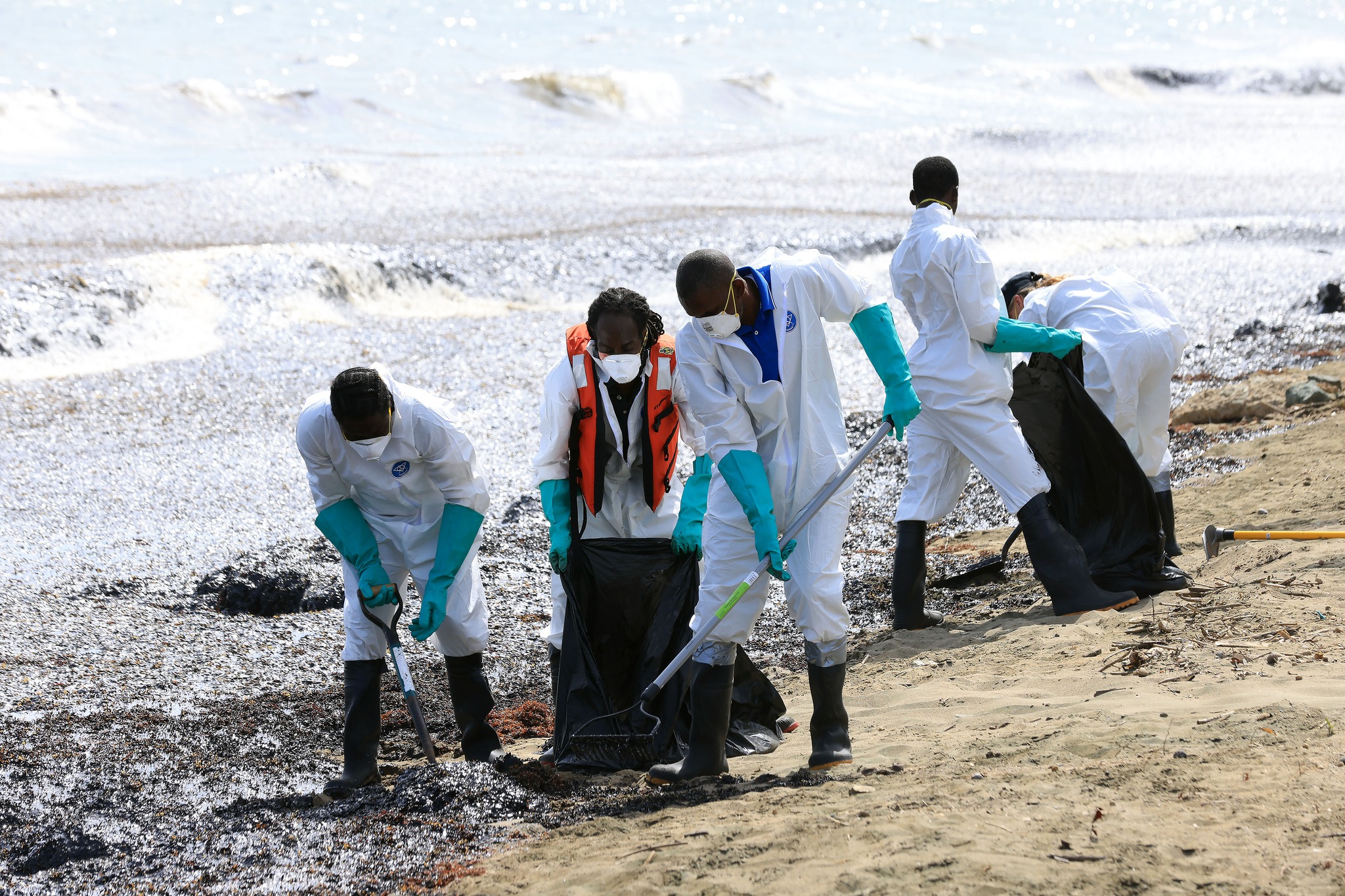
The more formal clean-up plan began on Thursday morning, with over 60 people working both on the coast and offshore to contain the oil-like substance. This included Tobago’s Public Health, CEPEP, URP, and CCC. The contingent was augmented with CERT volunteers, with a call for volunteers being put out on Saturday night by TEMA.
On Thursday morning, the Tobago Emergency Operations Center was activated at Level 2, indicating that national assistance has been sought and other stakeholders were brought in, including the Environmental Management Authority and the Office of Disaster Preparedness and Management. Oil spill response equipment and two vessels were also deployed. The THA indicated that they anticipate the disaster level would be raised to Level 3, meaning international assistance can be requested.
Though a typical nuisance, the mats of sargassum have proven useful, as they were absorbing or encapsulating the oil-like substance on shore and nearshore, leading to easy removal from the marine environment. The removed sargassum has been transported to a sealed containment area in Studley Park, Tobago.
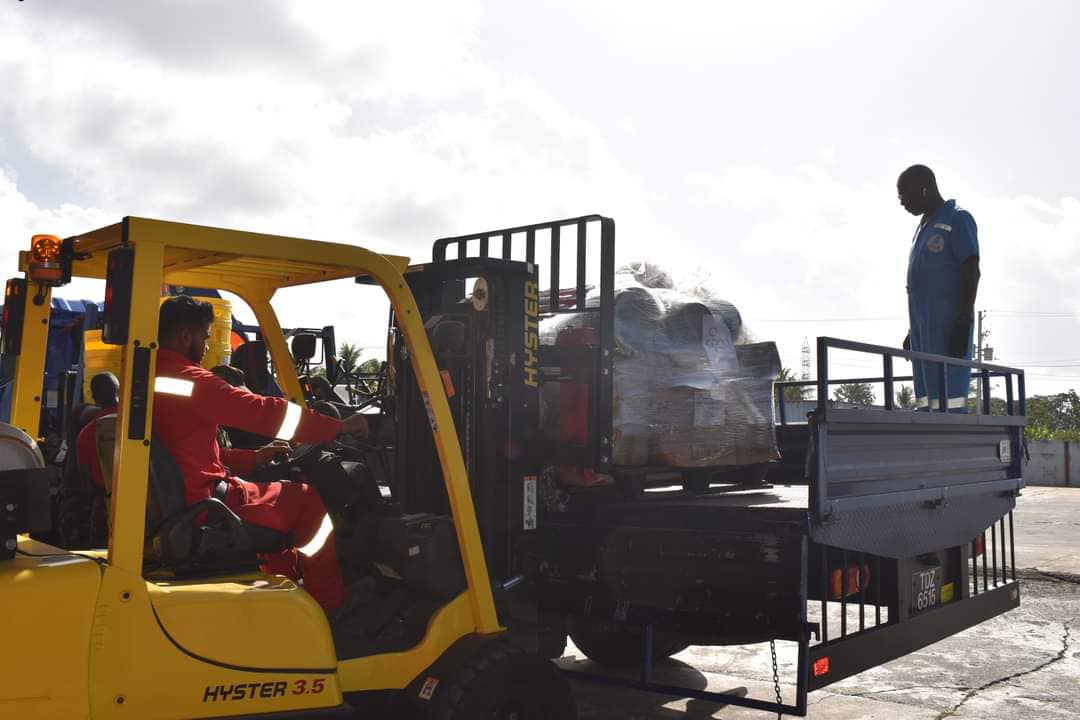
By Friday, Stuart Young, Minister of Energy and Energy Industry, and Rohan Sinanan, Minister of Works and Transport, had visited Tobago. Heritage Petroleum engaged subject matter experts from Health Safety Security and Environment (HSSE), logistics and field operations, with decades of experience in safely and efficiently managing hydrocarbon spills to head to Tobago to support clean-up operations on the island. The ODPM, with assistance from the Trinidad and Tobago Defence Force (TTDF), provided a number of Tyvek suits, hazmat bins, reflective vests, wheelbarrows, shovels, pitchforks, goggles, steel-toe boots, collapsible barrels, and roll polythene to the TEMA.
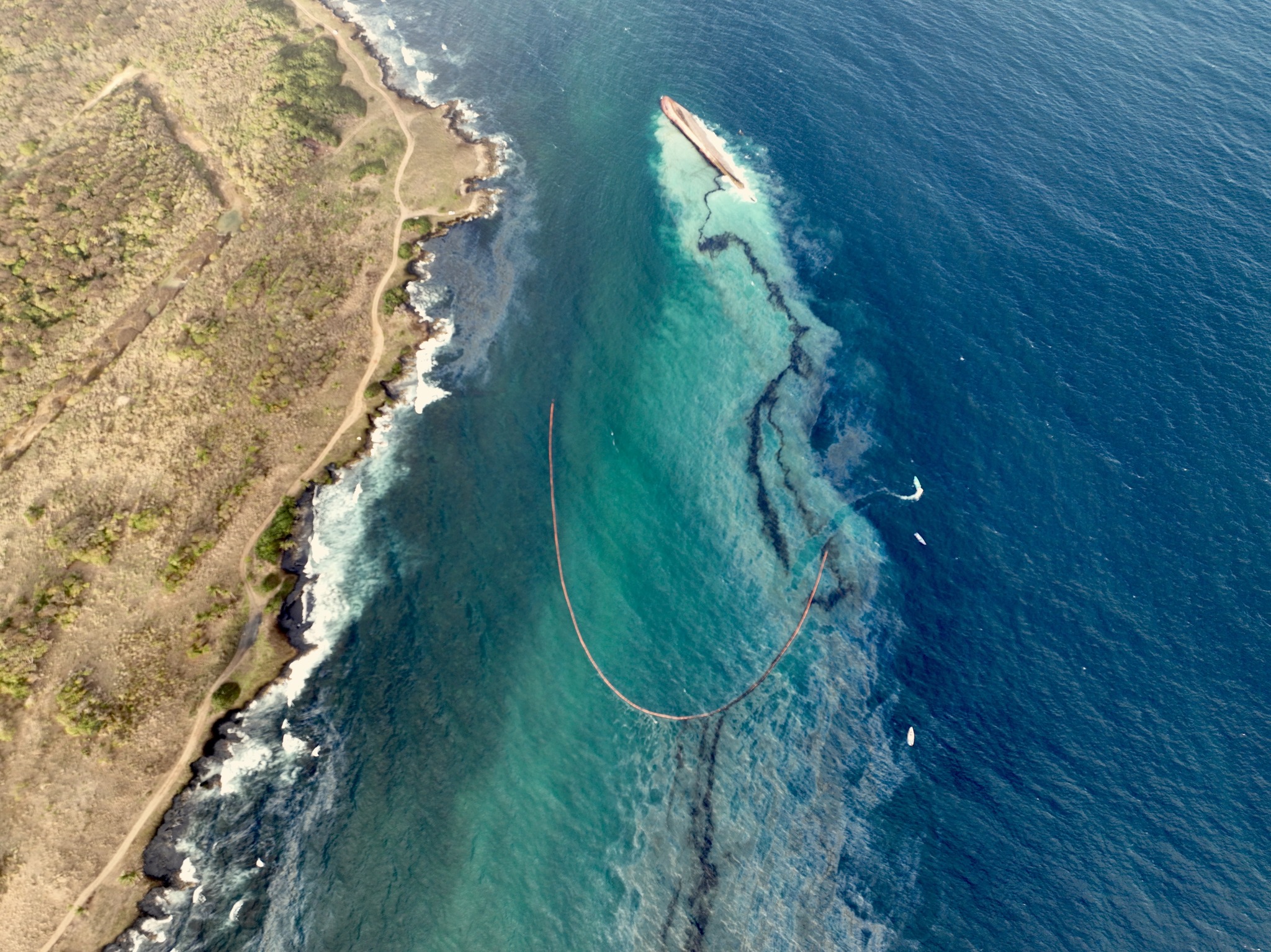
Booms were deployed Friday night into Saturday to cordon off the Port of Scarborough to ensure the harbour and docking area remain free from the oil-like substance with additional booms deployed near the Gulfstream vessel to control the movement of pollution.
Farley Augustine said the costs have come in at nearly one million TTD so far, but he still has to review each cost, and many invoices have yet to be submitted.
On Sunday, T&T’s Prime Minister, Dr Keith Rowley, is set to tour the disaster areas in Tobago impacted by the oil spill. Dr Rowley will also host a media conference at 12:30 p.m. at the Office of the Prime Minister – Central Administrative Services Tobago (CAST), Orange Hill Road, Scarborough.