


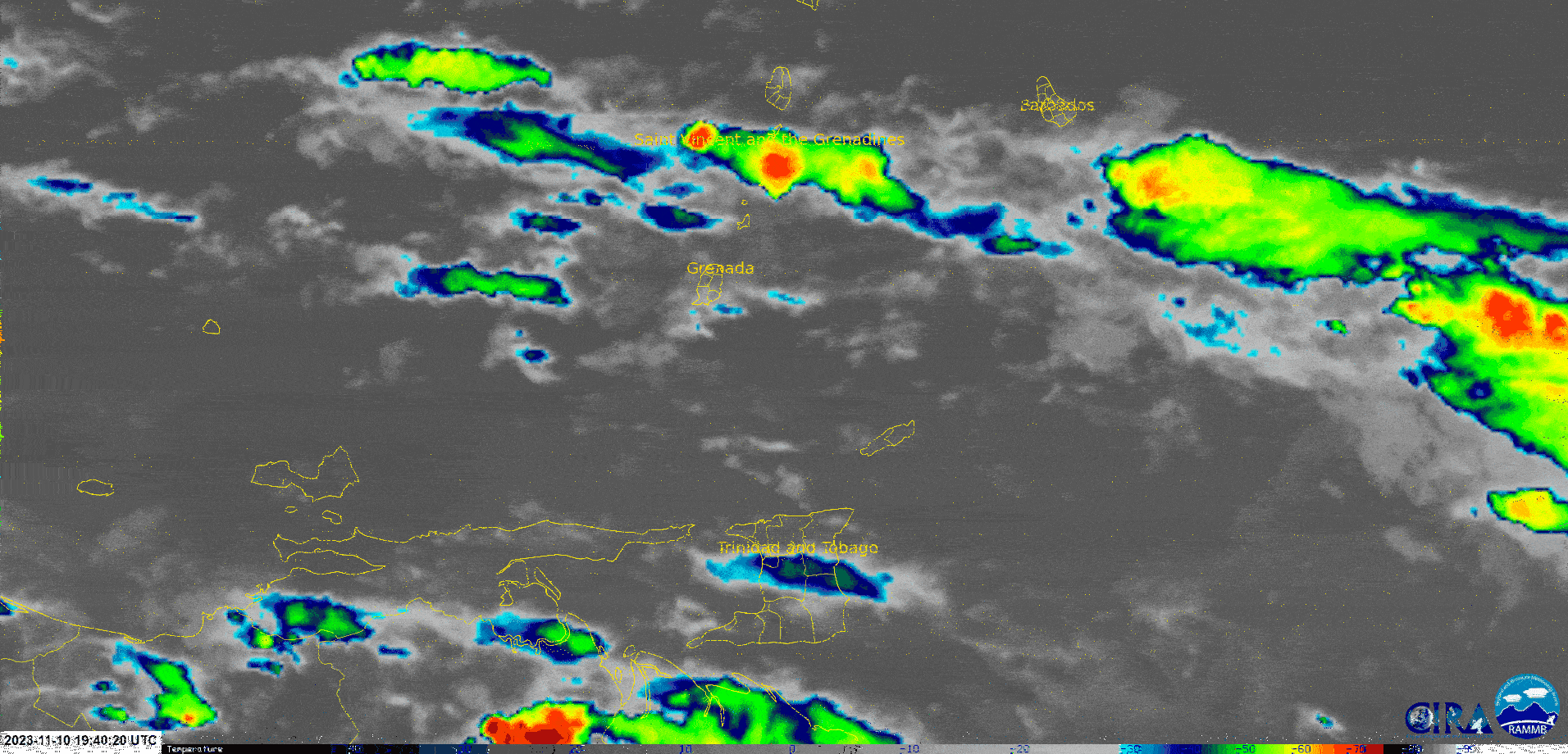
A combination of surface to low-level confluence, deep-layered moisture trailing a trough, and favorable upper-level conditions have supported rain, showers, and isolated thunderstorms mainly north of T&T over the last 12-18 hours. However, forecast models indicate this activity will intermittently affect the country through Sunday afternoon. The good news is that the latest forecast models have trended downwards for overall rainfall accumulations across Trinidad and Tobago, reducing flooding concerns.
What you need to know
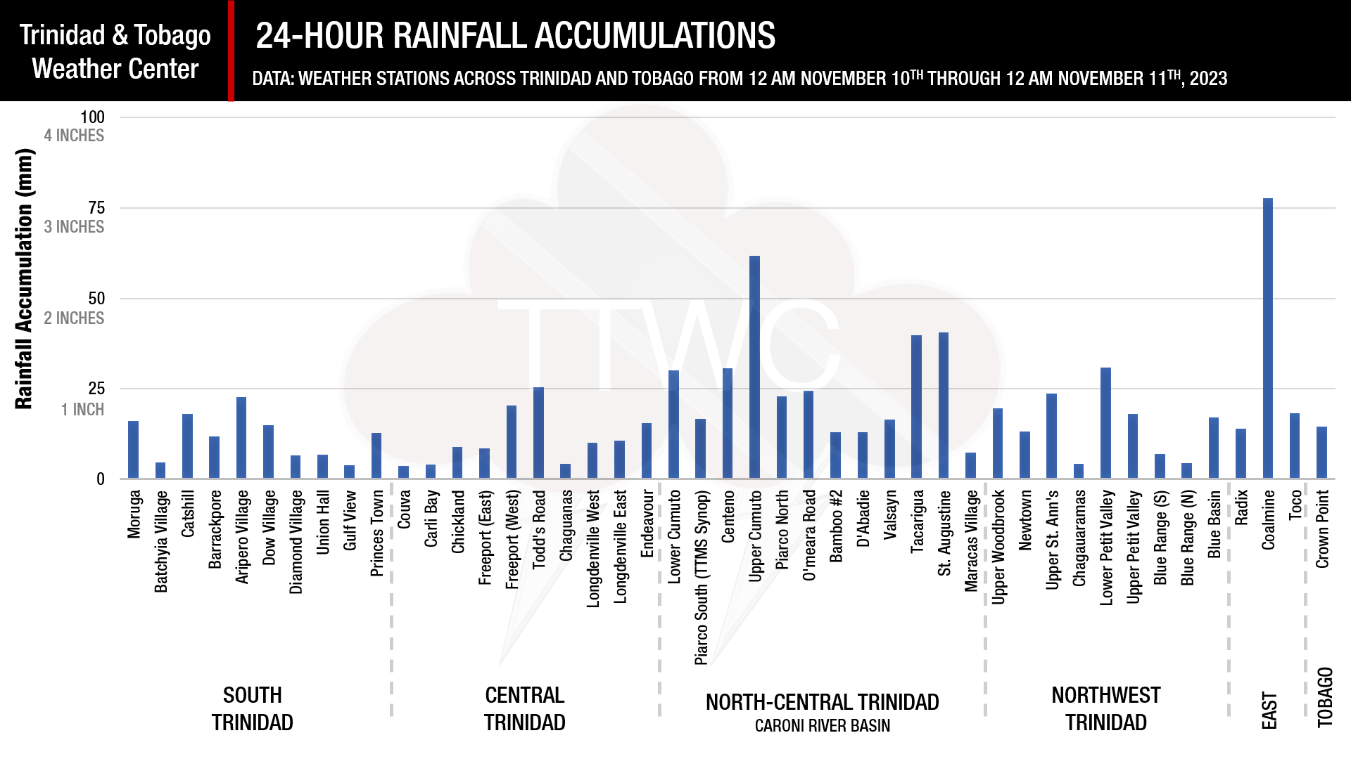
— Rainfall: Through Sunday night, forecast models have trended downward for additional rainfall accumulations across Trinidad and Tobago. For the western half of Trinidad, between 15 and 30 millimeters of rainfall is forecast, while across the eastern half of Trinidad and Tobago, between 30 and 75 millimeters of rainfall is forecast. Generally, eastern Tobago and northeastern Trinidad are forecast to record the highest rainfall accumulations.
— Hazards: The main hazards will originate from heavy showers and thunderstorms, producing cloud-to-ground lightning, gusty winds up to 55 KM/H (through Monday), and periods of heavy/violent rainfall, which can trigger street/flash flooding. Though riverine flooding concerns are low presently, eastern river basins and the Caroni River Basin will be monitored closely. In elevated areas of northern Trinidad and eastern Tobago, landslides are also possible, particularly as the weekend progresses. Seas are forecast to become locally agitated during heavy showers or thunderstorms.
Latest Alerts

Adverse Weather Alert Discontinued, Moderate Impacts Still Possible
Trinidad and Tobago is NOT under any tropical storm or hurricane threat, watch, or warning at this time.
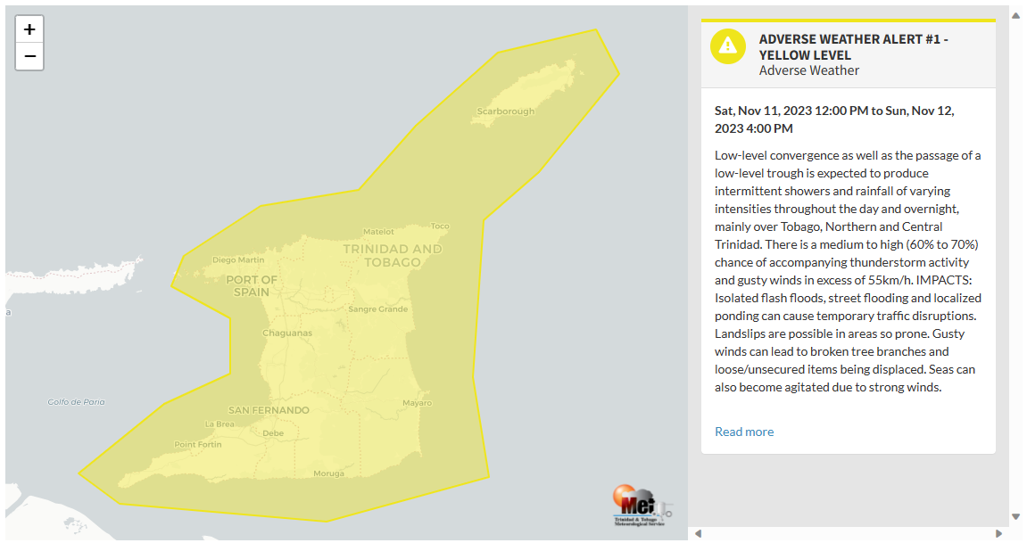
The Adverse Weather Alert
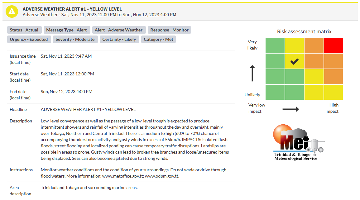
The Trinidad and Tobago Meteorological Service issued an Adverse Weather Alert (Yellow Level) on Saturday at 9:47 AM. The alert goes into effect for Trinidad and Tobago at 12:00 PM (noon) on Saturday, November 11th, 2023, and remains in effect through 4:00 PM Sunday, November 12th, 2023.
As mentioned earlier, the forecast of inclement weather is due to a combination of surface to low-level confluence, deep-layered moisture trailing a trough, and favorable upper-level conditions.
This “alert” status considers the possibility of the event occurring. This adverse weather event has been observed with the following impacts, according to the TTMS:
- Intermittent showers and rainfall of varying intensities throughout the day and overnight, mainly over Tobago, Northern and Central Trinidad. There is a medium to high (60% to 70%) chance of accompanying thunderstorm activity and gusty winds in excess of 55 KM/H.
- Isolated flash floods, street flooding, and localized ponding can cause temporary traffic disruptions.
- Landslips are possible in areas so prone.
- Gusty winds can lead to broken tree branches and loose/unsecured items being displaced.
- Seas can also become agitated due to strong winds.
What has happened
Heavy showers and isolated thunderstorms have affected Trinidad and Tobago from Friday afternoon. At Crown Point, Tobago, wind gusts between 30 and 55 KM/H have been recorded since 5:30 PM Friday, with sustained winds of 35 KM/H and a gust to 54 KM/H recorded at 6:03 AM Saturday during showers. At Piarco, winds up to 28 KM/H and a gust to 54 KM/H were recorded at 9:47 AM, ahead of showers.
Rainfall-wise, most areas have seen up to one inch (25 millimeters), with isolated areas across central and northern areas of Trinidad recording higher totals.
For Barbados, where a flood watch is in effect, 111.4 mm of rainfall was measured at Mount Pleasant, St. Philip, 66.2 mm and 65.6 mm were recorded at Chapel and Bushy Park, St. Philip and 35.6 mm was recorded at the Barbados Meteorological Service at Charnocks.

The color of the alert indicates the severity of the event and the probability of the event occurring. Currently, the alert level is Yellow. This means that the hazards have been observed, and the severity of the impacts is moderate for this particular alert. You should be aware of the hazards in your area associated mainly with gusty winds in excess of 55 KM/H and frequent lightning.
For a moderate Adverse Weather Alert, there is the potential for possible injuries, where behavioral changes are required to ensure safety. There may be minor damage to property, with income-earning temporarily disrupted and a couple of communities affected.
The Met Office is advising the public to monitor weather conditions and the condition of their surroundings. Do not wade or drive through flood waters.


