


There are no tropical waves currently analyzed between Trinidad and Tobago and the African Coast, but a series of surface-to-low-level troughs will continue to generate unsettled conditions across the Lesser Antilles over the next several days. The National Hurricane Center is monitoring a disturbance north of the Greater Antilles and the return of Tropical Storm Tammy in the North Atlantic Ocean.
What you need to know
— Tropical Wave 55: The axis of this tropical wave is located west of the Lesser Antilles and Trinidad and Tobago in the Caribbean Sea after moving across the region on Friday. The main rainmaker for T&T in the short term is a low-level trough east of the Lesser Antilles, forecast to affect the country and region on Sunday.
— Invest 96L: This area of low pressure is forecast to move into the far southwestern Atlantic Ocean, moving north of the Bahamas, where it could become a short-lived tropical depression or tropical storm.
— Tropical Storm Tammy: In Tammy’s second act, after regenerating in the open North Atlantic Ocean as a short-lived tropical storm, it is forecast to dissipate as early as Sunday morning due to hostile conditions.
— Hazards: There are no forecast tropical hazards for T&T during the next week. However, due to a series of low-level troughs, the proximity to the Intertropical Convergence Zone and a favorably positioned upper-level trough by mid-week, periods of showers and thunderstorms could produce localized gusty winds and flooding rainfall through the week. See the forecast for more information.
Tropical Wave 55
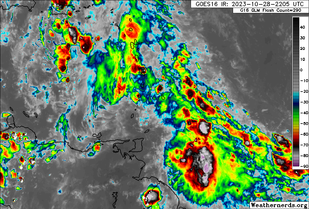
The 55th tropical wave for the 2023 Atlantic Hurricane season, though not formally analyzed by the National Hurricane Center but by all other regional and international meteorological offices, is now located in the Caribbean Sea west of the Lesser Antilles and T&T.
This wave is not forecast to further affect the Lesser Antilles, but scattered showers, cloudiness and isolated thunderstorms between the wave and a low-level to surface trough east of the region will continue through Monday.
Invest 96L
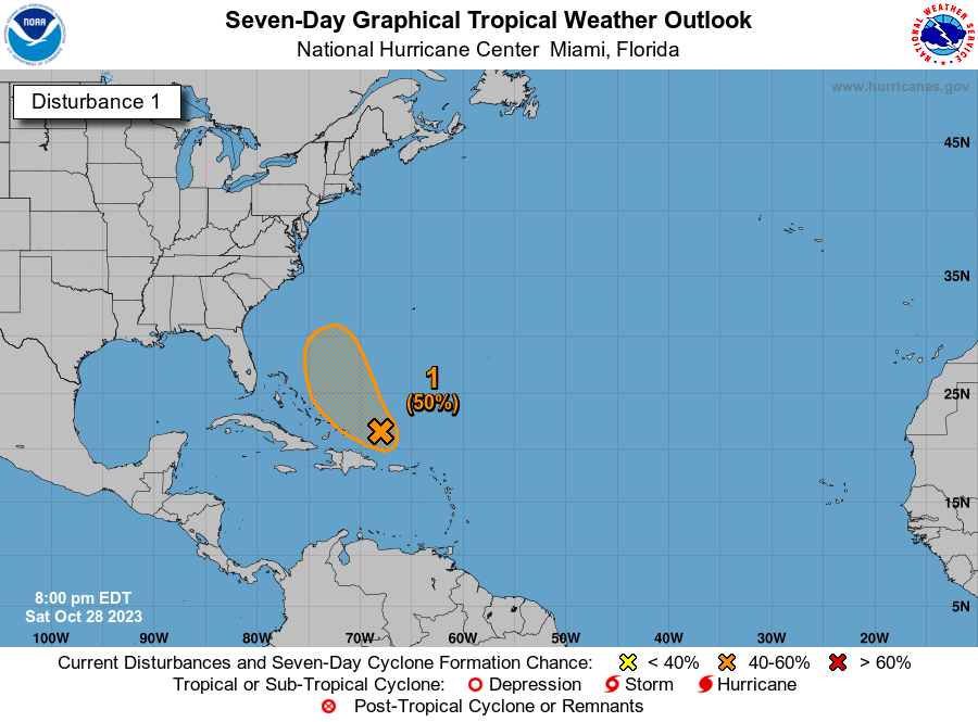
The National Hurricane Center (NHC) has been monitoring an area of low pressure that has formed north of the Greater Antilles for the last day or so and has shown some signs of organization with an increase in shower and thunderstorm activity on Saturday evening.
According to the NHC, while upper-level winds are only marginally conducive for further development, this system could become a short-lived tropical depression or storm over the next day or so. It has a medium chance (50%) of development over the next 48 hours and 7 days.
However, by Monday, upper-level winds are forecast to become too strong for further development as the system turns northward to the east of the northwestern Bahamas.
Regardless of development, this system is not forecast to pose any direct or indirect threat to the Lesser Antilles at this time.
Tropical Storm Tammy
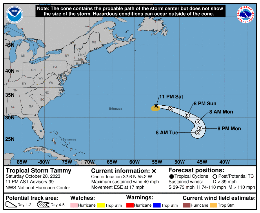
Tropical Storm Tammy’s second act in the North Atlantic Ocean is set to be quite shortlived, after reforming just over 36 hours ago as of 11:00 PM Saturday.
According to the NHC, while some sheared puffs of moderate convection have attempted to re-form off to the northeast of an increasingly elongated circulation center, this activity lacks sufficient organization to maintain Tammy as a tropical cyclone. The NHC has continued advisories in the event that there could be one final nocturnal burst of deeper convection closer to the center.
In the meantime, satellite intensity estimates and recent ASCAT data suggest some continued spin-down from this afternoon, and the initial intensity was set at 65 KM/H on Saturday night. If more organized convection does not return soon, Tammy could become a post-tropical low as soon as overnight, and likely during the day tomorrow as the storm succumbs to the increasingly hostile high shear and dry mid-level air environment.
Tammy is beginning to lose latitude, with the estimated motion now east-southeast. Over the next 2-3 days, Tammy or its remnant low should be primarily steered clockwise around an amplifying ridge to the storm’s north and west. This should result in a further turn southeastward and then southward before the low-level circulation opens up into a trough.
Not Every Tropical Wave Brings Severe Weather
Tropical waves vary in intensity as they travel westward across the Atlantic. This variability can be on the order of days to as short term as hours. Sometimes, you may see satellite imagery that shows heavy thunderstorms and deep convective activity east of Trinidad and Tobago during the late night and early morning, but by daybreak – nothing.
This is due to diurnal (daily) variations in convective showers whereby convection peaks overnight and wanes during the day for already occurring convective systems (i.e., not triggered by daytime heating).
Activity can be enhanced by its proximity to upper-level troughs and the ITCZ but can also be degraded by hostile upper-level conditions and Saharan Dust.
As we progress through October, tropical waves are forecast to gradually decrease in intensity and frequency, but low-level troughs interacting with the ITCZ and occasional tropical wave activity in the past have led to prolific rainfall events in the country.


