


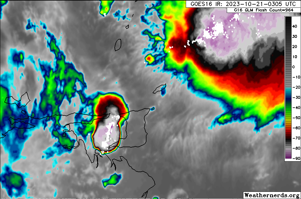
Intense thunderstorms moved off western Venezuela into the Gulf of Paria and then across Trinidad late Friday night into Saturday morning, producing severe lightning, with GOES-East GLM detecting nearly 5,000 lightning strikes across T&T between 10:05 PM Friday and 3:05 AM Saturday. As a result, a short-notice Adverse Weather Alert (Yellow Level) was issued for the Gulf of Paria and the western half of Trinidad.
What you need to know
— Rainfall: These thunderstorms are not producing significant rainfall totals across the country, with 10-35 millimeters of rainfall recorded over the last 6 hours. Through Saturday night, additional periods of rain with isolated to scattered moderate to heavy showers and thunderstorms are forecast, interrupting partly to mostly cloudy skies, producing between 5-10 millimeters with isolated totals up to 25 millimeters.
— Hazards: The main hazard will be frequent lightning and gusty winds generally up to 45 KM/H, with a low to medium risk of street and flash flooding in heavy showers and thunderstorms. Localized wind and lightning damage, such as fallen trees and roof damage, is possible. Seas are forecast to become locally agitated during heavy showers or thunderstorms.
Latest Alerts

Hazardous Seas Alert Discontinued For T&T
Trinidad and Tobago is NOT under any tropical storm or hurricane threat, watch, or warning at this time.
The Adverse Weather Alert
The Trinidad and Tobago Meteorological Service issued an Adverse Weather Alert (Yellow Level) on Friday at 10:43 PM. The alert retroactively went into effect for western Trinidad and the Gulf of Paria at 10:40 PM on Friday, October 20th, 2023, and remains in effect through 8:00 PM Saturday, October 21st, 2023.
Trinidad and Tobago is not under any tropical storm watch or warning at this time.


The forecast inclement weather is due to Hurricane Tammy’s feeder bands, coupled with a favorable atmospheric environment.
This “alert” status takes into account the possibility of the event occurring. This adverse weather event has been observed with the following impacts, according to the TTMS:
- A band of very active thunderstorms that originated over the Venezuelan mainland is now propagating towards the western half of Trinidad. Offshore marine areas in the Gulf of Paria will also be affected.
- Frequent heavy showers and thunderstorms with accompanying gusty winds are likely.
- Additionally, electrical discharge from lightning will also pose a threat.
- Seas in offshore areas in the Gulf of Paria may also become agitated.

The color of the alert indicates the severity of the event and the probability of the event occurring. Currently, the alert level is Yellow. This means that the hazards have been observed, and the severity of the impacts is moderate for this particular alert. You should be aware of the hazards in your area associated mainly with gusty winds in excess of 45 KM/H, as well as frequent lightning.
For a moderate Adverse Weather Alert, there is the potential for possible injuries, where behavioral changes are required to ensure safety. There may be minor damage to property, with income-earning temporarily disrupted and a couple of communities affected.
The Met Office is advising the public to monitor weather conditions and the condition of their surroundings. Do not wade or drive through flood waters.


