Trinidad and Tobago have recorded extremely hot temperatures over the last week as the country remains under a prolonged heat wave, leading the Trinidad and Tobago Meteorological Service to place the country under a Hot Spell Warning.
While Trinidad has yet to surpass October 18th, 2020’s record of 35.5°C, maximum high temperatures at Piarco have reached or crossed 35.0°C three times this year already, a first since 2020.
Latest Alerts

Localized Flood Alert Discontinued For Trinidad
Trinidad and Tobago is NOT under any tropical storm or hurricane threat, watch, or warning at this time.
T&T’s Record Heat to Date
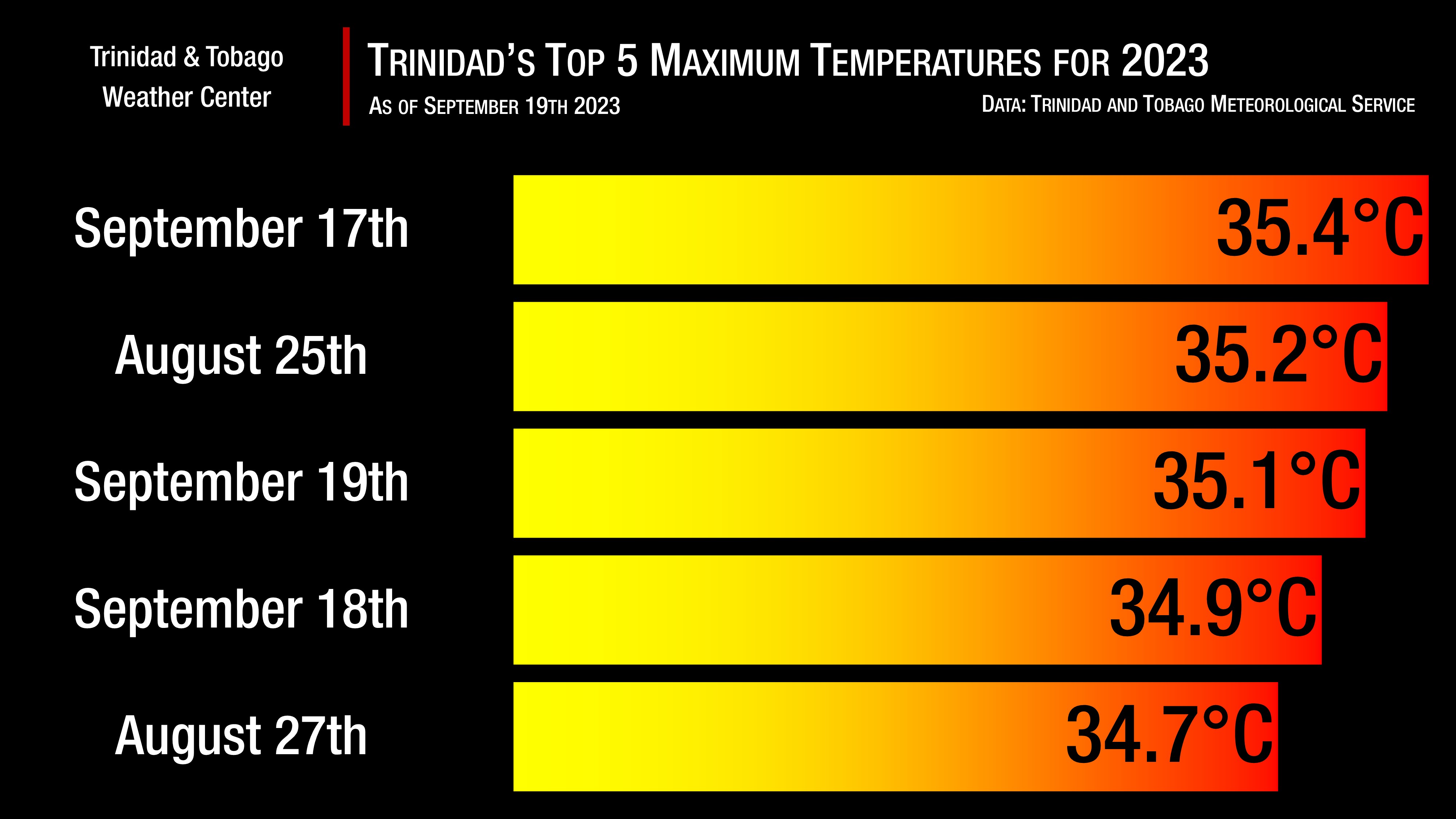
At Trinidad’s climate reference site, Piarco, maximum high temperatures over the last 3 days (September 17th through 19th) have ranked in the top five hottest days for the year so far. During this period, maximum high temperatures between 34.9°C and 35.4°C were recorded, with the highest recorded on September 17th, becoming the hottest day for 2023.
This is based on data from the Trinidad and Tobago Meteorological Service (TTMS) and cross-checked by the Met Office’s Climatology Division. Maximum high temperatures reported in the daily 4:00 PM forecast from the TTMS only account for the highest temperature during that day until 2:00 PM, but on hot days, hotter temperatures are recorded after that cutoff period, and these higher temperatures are not necessarily reported to the public.
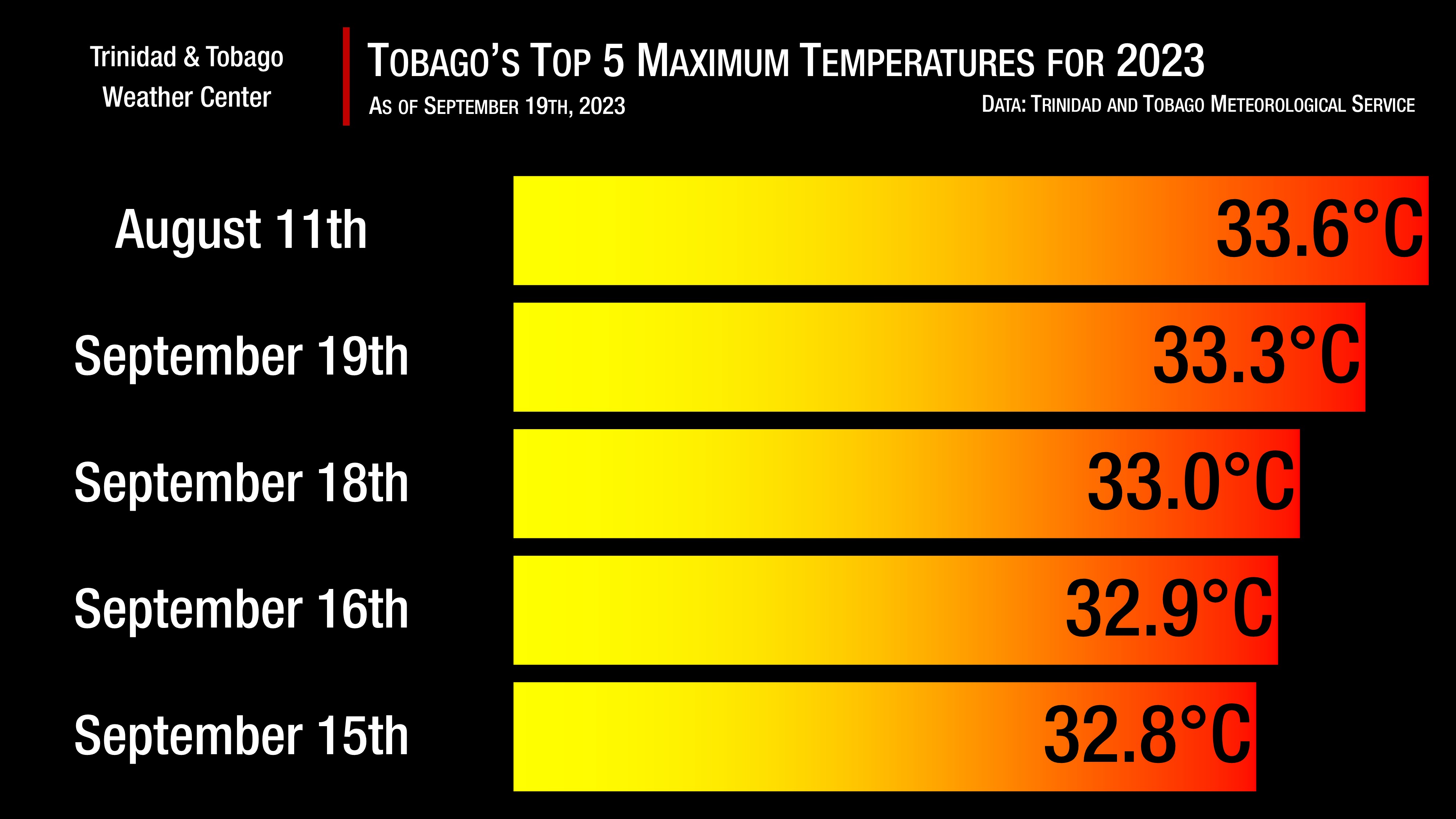
Meanwhile, Tobago has recorded equally hot days by the island’s standard at the climate reference site located at Crown Point. While maximum high temperatures in September have not surpassed the August 11th 33.6°C, temperatures over the last week have been in the top 10% of maximum high temperatures for Tobago’s climate record.
Since September 9th, Crown Point has recorded maximum high temperatures greater than 32.0°C, the cutoff for the top 10% of maximum high temperatures on the island.
Though temperatures have been excessively warm, the feels-like temperature, or the heat index, has been at dangerous levels for the past five to seven days across the country. The heat index is a calculation of what the outside feels like based on the recorded air temperature and humidity (measured by relative humidity or dew point), so it is not what you see on a thermometer but can be several degrees hotter. The heat index is important because of sweating. Your body sweats to cool the skin and maintain a constant, healthy body temperature. If the humidity is too high, sweat will not be able to evaporate, and you will feel much hotter.
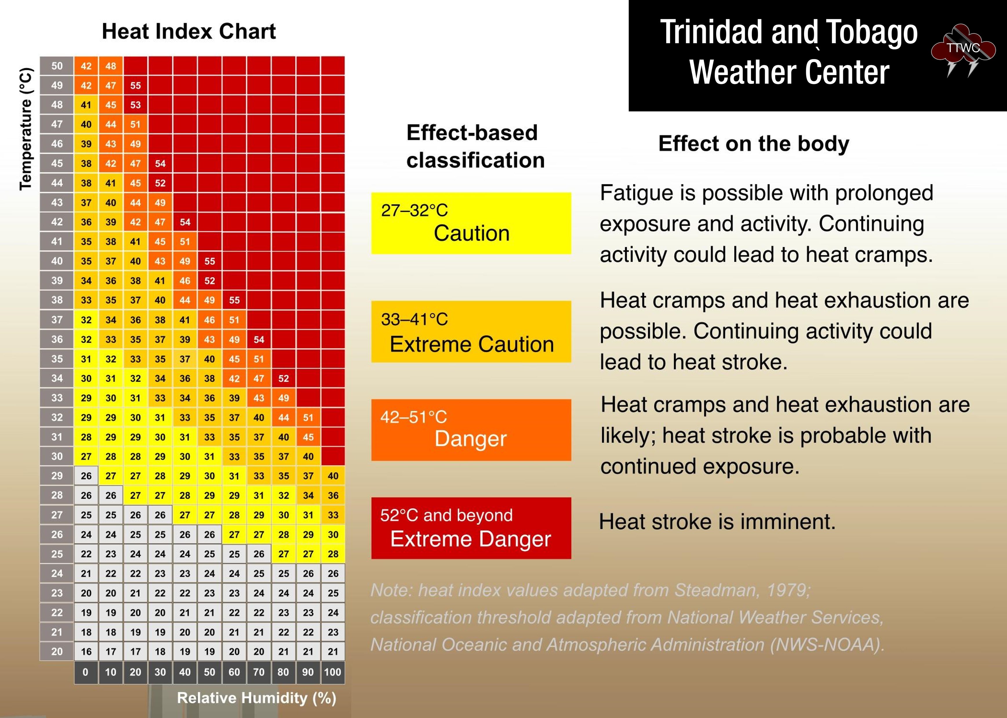
For the last week, heat indices have ranged between 38°C to 53°C, solidly in the dangerous to occasionally reaching extreme danger.
What’s causing the excessive heat?
Since mid-August, multiple tropical cyclones have safely moved north of Trinidad and Tobago. The result of these stronger low-pressure systems traversing north of the region is weaker surface winds, coming from the southeast and south, to near calm and calm at times.
Though the mid to upper-level environment remains fairly dry, the low-level environment has marginal amounts of moisture, which leads to elevated humidity. As a result, high amounts of warm air remaining near the surface, while at night, occasional mid/upper-level clouds prevent the escape of heat into the atmosphere. T
The result is warm, humid nights and hot, humid days across not only Trinidad and Tobago but the remainder of the Lesser Antilles.
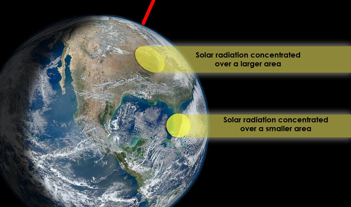
On a larger scale, the solar altitude, or the angle of the sun relative to the Earth’s horizon, is at 90° across T&T (occurred on August 25th). When this occurs, solar radiation is concentrated over a smaller surface area, causing warmer temperatures.
Trinidad and Tobago is also entrenched in its heat season, which runs from March to October, with the first peak in April and May and the second peak in late August through early October. During these months, the islands experience mostly hot sunny periods and warm nights. Winds are generally weak but occasionally moderate strength from the east to southeast with speeds of 20-30 KM/H.
According to the Met Office, there are many climatic features working together to promote warmer to hotter days this month. “The winds are calm to light, with fewer cloudy periods, which enables greater incoming solar radiation, particularly during the mid-morning to afternoon periods:
- A moderately strong El Nino which generally restricts cloud development.
- A negative phase of the North Atlantic Oscillation (NAO) encourages weak winds across the Caribbean.
- A warmer than usual Atlantic Ocean Sea Surface Temperatures (SSTs) east of the Trinidad and Tobago.
- The apparent local position of the sun at our latitude.
- The southeasterly flow of wind from the equatorial region.
Marginally Cooler Temperatures Coming
Across both islands, from Wednesday afternoon, the Intertropical Convergence Zone, interacting with the passage of a tropical wave on Thursday, is forecast to produce showers, isolated thunderstorms, and cloudy skies, bringing some much-needed heat relief to the country. However, hot and sunny conditions return by the weekend.
Wednesday
Low: 25-27°C
High: 32-34°C
Thursday
Low: 24-26°C
High: 29-32°C
Friday
Low: 24-26°C
High: 31-34°C
Saturday
Low: 24-27°C
High: 32-35°C
Sunday
Low: 24-27°C
High: 32-35°C
Temperatures in cities, such as Port of Spain, tend to be much higher than in surrounding locations due to a phenomenon called the Urban Heat Island Effect. There are several causes, but the main instigator for this phenomenon tends to be increased dark surfaces, such as roads and pavement in cities, which absorb solar radiation more than surrounding areas.
On Wednesday, the heat index is forecast to remain between levels that require extreme caution to dangerous levels, dropping to levels that require caution and extreme caution through Friday, even with increased cloud cover. By Saturday into next week, the heat index is forecast to remain between levels that require extreme caution to dangerous levels. For Thursday and Friday, across Trinidad and Tobago, the maximum heat index is forecast to be between 32°C and 35°C and even higher in urbanized areas. On Wednesday and from Saturday, the maximum heat index is forecast to be between 35°C and 48°C.