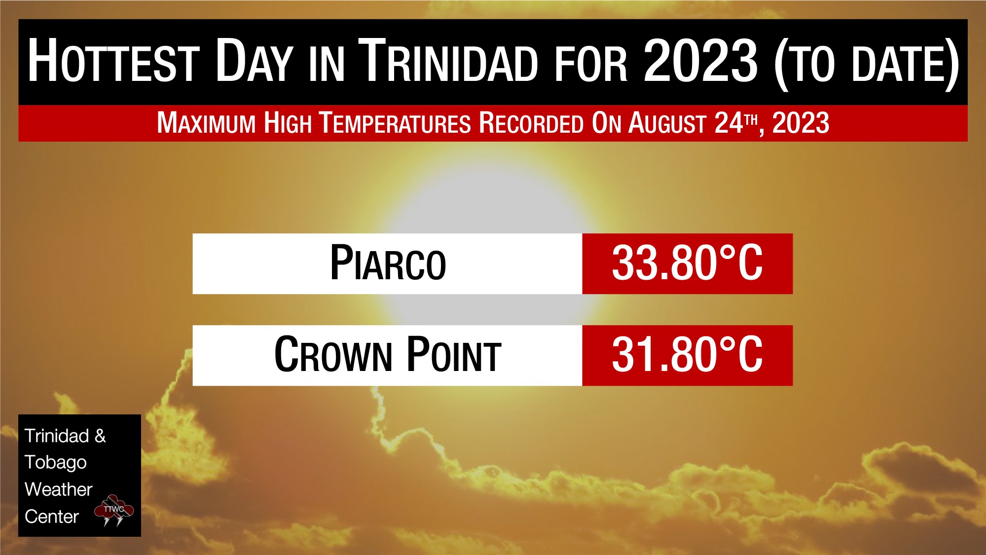
On Thursday, thermometers at Piarco recorded 33.8°C, breaking the August 7th record, making it the hottest day for the year at Trinidad’s climate reference site, while at Crown Point, Tobago, the maximum high was a quite humid 31.8°C.
However, minimum lows were far more substantial when looking at T&T’s climate record. Today was the warmest morning of the year so far, with minimum lows at Piarco and Crown Point coming in at 27.2°C and 28.7°C respectively, well above the long-term averages of 24.0°C for Piarco and 24.9°C for Crown Point. These departures from average were so high they rank as the 3rd warmest (tied with yesterday, August 23rd) minimum low temperature for Piarco and the 2nd warmest for Crown Point on record.
Over the last week, the remnants of Tropical Storm Gert lingered east of the Leeward Islands, leading to light southerly winds, to near calm at times, with high levels of atmospheric moisture leading to warm air remaining near the surface, while at night, mid/upper-level clouds prevent the escape of heat into the atmosphere. The result is warm, humid nights and hot, humid days across not only Trinidad and Tobago but the remainder of the Lesser Antilles.
While it isn’t officially considered a heat wave across Trinidad and Tobago (more on this later), countries further up the island chain, like Antigua and Barbuda, have issued an Excessive Heat Warning through next Tuesday.
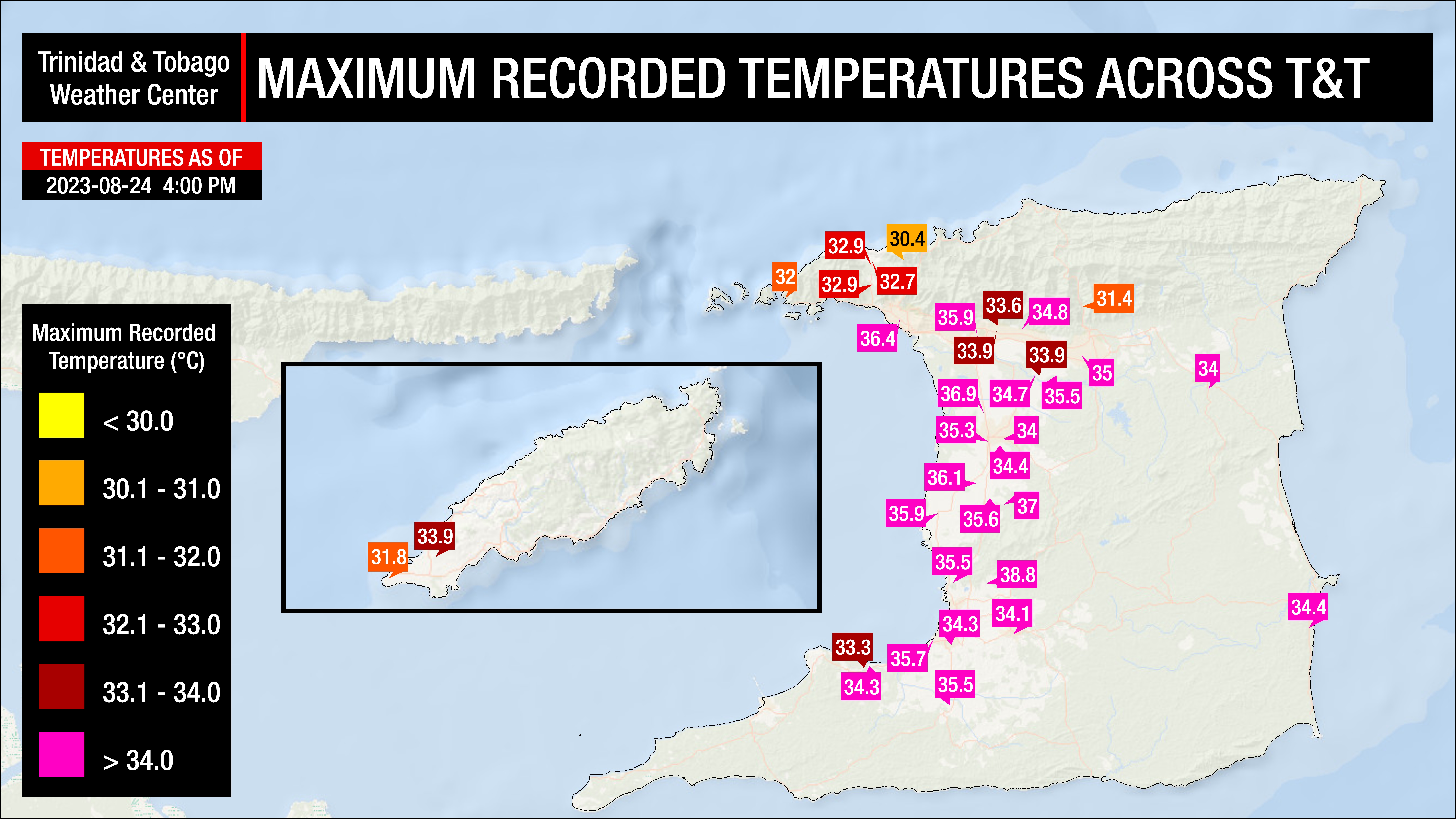
On Thursday, across most of the country, temperatures ranged between 34.0°C and 37.0°C, mainly across Trinidad. Increased cloud cover across northern Trinidad and western Tobago kept the temperatures marginally cooler. In urban areas and areas where development is prevalent, temperatures trended higher.
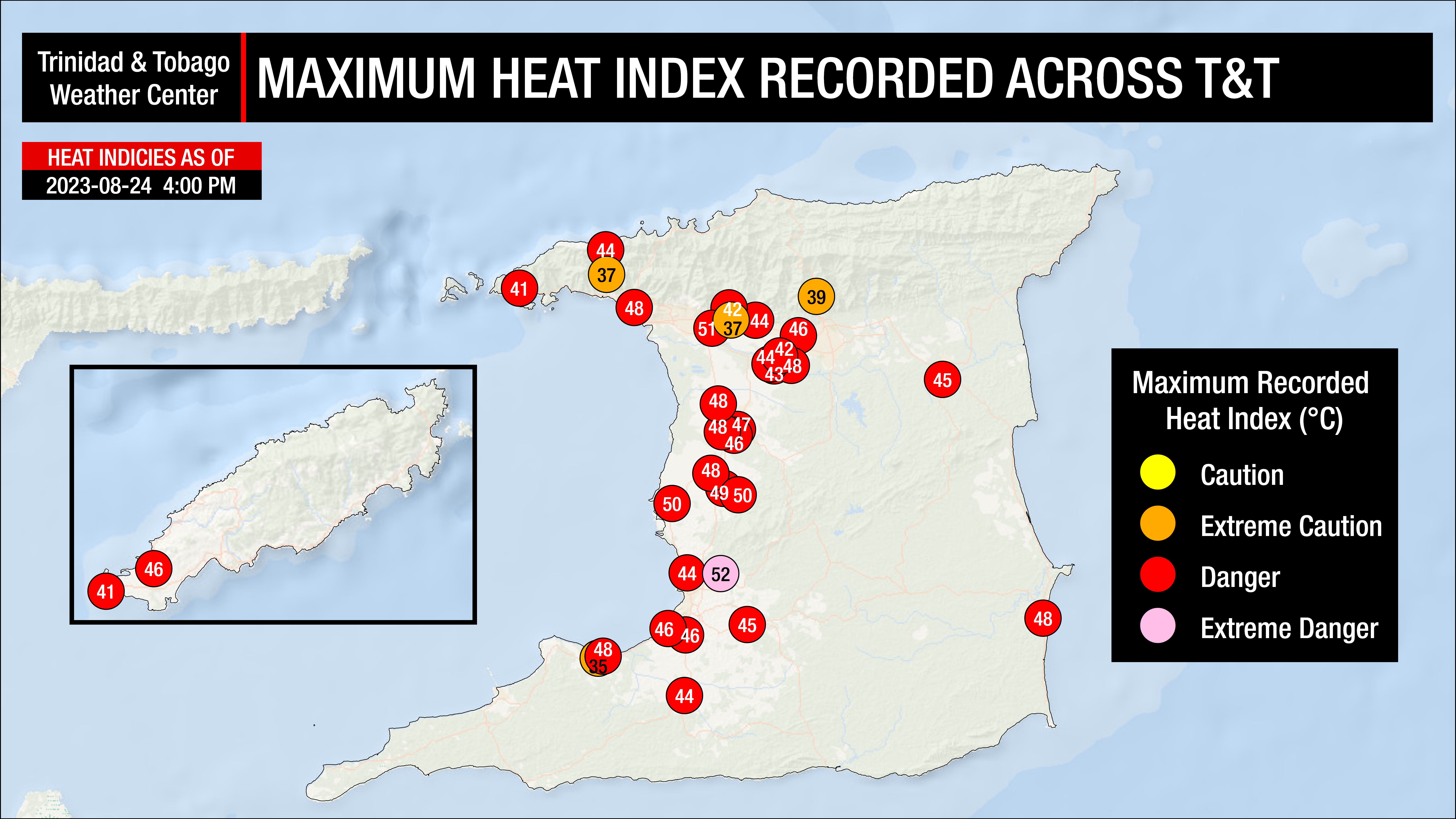
With abundant moisture present at the lowest levels of the atmosphere, the heat indices remained high, in the dangerous category across much of Trinidad and Tobago.
Where do these temperatures stand compared to our records? The hottest recorded temperature for August in Trinidad, according to the Trinidad and Tobago Meteorological Service (1946-2022), stands at 35.8°C recorded on August 23rd, 2017, while at Crown Point, Tobago, the maximum high was 34.2°C recorded on August 28th, 2008. At Piarco International Airport, the hottest temperature ever was recorded on September 25th, 1990, at 36.5°C.
Hot Temperatures Continue
Across both islands, hot conditions are forecast over the next several days. However, with a marginal surge in moisture on Saturday, some increased cloud cover could keep temperatures on the “cooler” side. On Tuesday, the Intertropical Convergence Zone, interacting with the passage of a tropical wave, is forecast to produce showers, isolated thunderstorms, and cloudy skies, bringing some much-needed heat relief to the country.
Friday
Low: 26-28°C
High: 32-36°C
Saturday
Low: 26-28°C
High: 32-36°C
Sunday
Low: 26-28°C
High: 33-37°C
Monday
Low: 26-28°C
High: 32-36°C
Tuesday
Low: 26-28°C
High: 29-31°C
Over the next five days, maximum high temperatures are forecast to be hot, near 33°C to 34°C at Piarco, trending slightly cooler on Tuesday. At Crown Point, maximum high temperatures are forecast to remain near 32°C, with similar cooler weather on Tuesday. Generally, higher temperatures are forecast across urbanized areas of Trinidad on Friday through the weekend, where in built-up areas, maximum high temperatures are likely to exceed 34°C. Minimum lows are forecast to remain warm, ranging between 26°C and 28°C in Trinidad and Tobago, trending marginally cooler in interior areas. The heat index will generally be above 35°C through the forecast period, outside of Tuesday.
Temperatures in cities, such as Port of Spain, tend to be much higher than in surrounding locations due to a phenomenon called the Urban Heat Island Effect. There are several causes, but the main instigator for this phenomenon tends to be increased dark surfaces, such as roads and pavement in cities, which absorb solar radiation more than surrounding areas.
The heat index will be between levels that require extreme caution to near dangerous levels over the next five days across Trinidad and Tobago. The heat index is a combination of air temperature and relative humidity, determining what the air feels like to a person, i.e., how hot it actually feels.
Across Trinidad, the maximum heat index is forecast to be between 35°C and 50°C and even higher in urbanized areas. In Tobago, the maximum heat index is forecast to be between 35°C and 45°C.
The heat index is important because of sweating. Your body sweats to cool the skin and maintain a constant, healthy body temperature. This cooling process means that the sweat has to evaporate off the skin to remove heat. However, if the sweat is unable to evaporate, the body isn’t able to regulate temperature.
Is this a heatwave?
Not yet.
Currently, the forecast maximum high temperature is forecast to be between 33.0°C and 34°C at Piarco, Trinidad, and between 31.0°C and 33.0°C at Crown Point, Tobago.
For a hot spell to be declared in Trinidad and Tobago by the Trinidad and Tobago Meteorological Service, a period of hot temperatures, characterized by maximum temperatures of at least 34.0°C in Trinidad and 32.0°C in Tobago, lasting five or more consecutive days. A short-duration hot spell is three or more consecutive hot days.