


Over the next five days, two tropical waves are forecast to move across Trinidad and Tobago, with the stronger wave affecting the country today (Wednesday) through Thursday. However, while isolated areas could see locally high rainfall totals, widespread heavy rainfall is not forecast.
What you need to know
— Rainfall: Over the next five days, between 10 and 25 millimeters are forecast across Trinidad and Tobago, with areas along eastern Trinidad and coastal areas receiving up to 50 millimeters. In isolated areas across western and eastern coastal Trinidad, locally higher amounts are possible daily.
— Saharan Dust: Elevated Saharan Dust concentrations are forecast across T&T, particularly from August 14th.
— Hazards: Over the next five days, but particularly Wednesday and Thursday, the main hazards will be localized street/flash flooding and gusty winds exceeding 45 KM/H in heavy showers and isolated thunderstorms. The threat of gusty winds will be elevated on Thursday.
— Marine: Seas are forecast to be slight to moderate, with waves in open waters ranging between 1.0 and 1.5 meters, while in sheltered areas, seas are forecast to be near calm, with waves remaining below 0.5 meters.
Latest Alerts

High Wind Alert Remains In Effect For T&T
Trinidad and Tobago is NOT under any tropical storm or hurricane threat, watch, or warning at this time.
The Forecast
Wednesday
WednesdayThursday
ThursdayFriday
FridaySaturday
SaturdaySunday
SundayMarine Forecast

Seas Forecast: Long-Period Swells To Return Next Week
Temperatures
Wednesday
Low: 24-26°C
High: 29-33°C
Thursday
Low: 24-26°C
High: 30-34°C
Friday
Low: 25-27°C
High: 31-35°C
Saturday
Low: 25-27°C
High: 32-35°C
Sunday
Low: 25-27°C
High: 31-34°C
Over the next five days, maximum high temperatures are forecast to be hot, ranging from 30°C to 35°C, with higher temperatures across urbanized areas of Trinidad, particularly after Thursday, where in built-up areas, maximum high temperatures are likely to exceed 34°C. Minimum lows are forecast to remain mild, ranging between 24°C and 27°C in Trinidad and Tobago, trending marginally cooler in interior areas. The heat index will generally be above 30°C through the forecast period and higher than 35°C from Friday.
Forecast Impacts
Flooding
FloodingForecast Rainfall Totals
- Wednesday: Between 5 and 15 millimeters across T&T, with totals up to 25 millimeters favoring the northern and eastern halves of Trinidad, as well as Tobago. In highly isolated downpours favoring the western half of Trinidad, local rainfall totals could exceed 25 millimeters.
- Thursday: Between 5 and 10 millimeters across T&T, with isolated totals up to 20 millimeters. In highly isolated downpours, favoring but not limited to the western half of Trinidad, local rainfall totals will exceed 25 millimeters.
- Friday: Less than 5 millimeters of rainfall across T&T, with isolated rainfall amounts up to 25 millimeters favoring western coastal Trinidad.
- Saturday: Between 0 and 5 millimeters of rain across T&T, with isolated totals nearing 15 millimeters across eastern and western coastal areas of both islands. In thunderstorm activity, locally higher totals are possible.
- Sunday: Between 5 and 15 millimeters of rain across T&T, with isolated totals exceeding 15 millimeters across eastern coastal Trinidad, as well as northern and western areas of both islands. In thunderstorm activity, locally higher totals are possible.
Understanding Rainfall Rates

Understanding Rainfall Accumulations
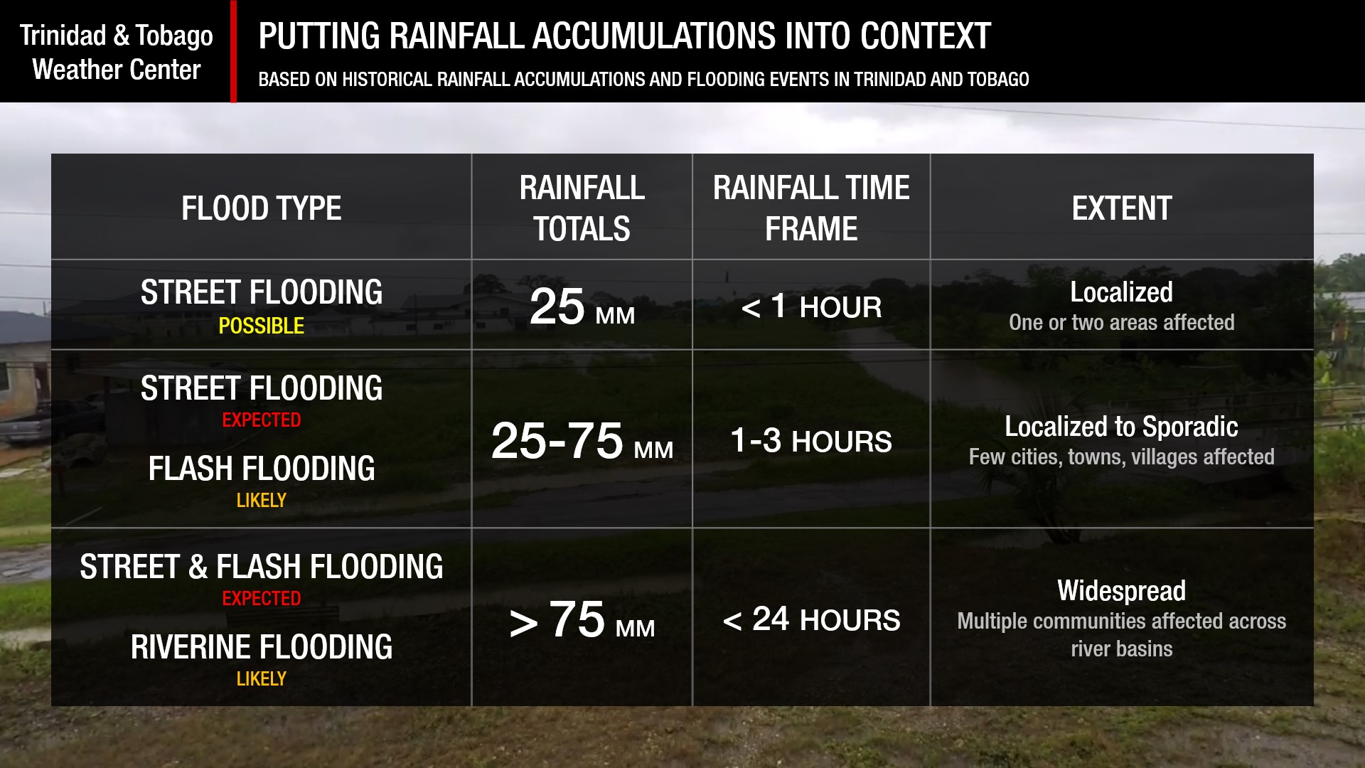
Putting the rainfall forecast into context, rainfall rates in excess of 50 millimeters per hour or areas that receive in excess of 25 millimeters within an hour tend to trigger street flooding across the country or flash flooding in northern Trinidad. For riverine flooding to occur, a large area of the country (not just in highly localized areas of western coastal Trinidad) would have to record upwards of 75 millimeters within 24 hours, and rainfall would have to fall across major rivers’ catchment areas.
Strong Thunderstorms
Strong ThunderstormsWhat is a strong or severe thunderstorm?
Given how rare these types of thunderstorms are in our region – we classify a severe or strong thunderstorm as one that produces any of the following:
- Damaging wind gusts exceeding 55 KM/H;
- Frequent lightning (more than 30 cloud-to-ground strikes within a 10-minute period);
- Hail (of any size);
- Rainfall of more than 50 millimeters or more within an hour or exceeding 75 millimeters or more within three hours;
- The sighting of a funnel cloud or touchdown of a waterspout/tornado associated with the thunderstorm.
Gusty Winds
Gusty WindsPossible impacts include localized wind damage to trees, power lines, and small structures. Small potted plants may blow over with light outdoor objects becoming airborne in stronger gusts. Tents may jump.
Other Hazards
Saharan Dust Forecast

Next Saharan Dust Surge Forecast By Mid-Next Week
Why I May Not/Will Not See Rainfall?
A frequent complaint is the forecast is wrong because I didn’t experience any rainfall. Scattered showers mean that you, individually, may experience some showers intermittently throughout the day, and there is a higher chance for this activity than isolated activity. Widespread showers mean that nearly all persons and areas may experience rainfall.
During the forecast period, isolated to scattered rainfall is forecast, with isolated activity favoring Friday into Saturday.

Forecast Discussion
Tropical Update

Tropical Update: Atlantic Remains Quiet, Tropical Wave To Bring Rainfall To T&T
On Wednesday into Thursday, Tropical Wave 32 is forecast to move across Trinidad and Tobago. While the strongest convection (heavier showers, stronger thunderstorms) is forecast to remain north of T&T, there is the potential for isolated strong convection across the country. Favorable mid to upper-level conditions with deep tropical moisture are forecast to prevail across the Windwards, including T&T, with light southerly to southeasterly and, at times, near calm winds.
While showers and thunderstorms are likely to also move in from the east associated with TW32, local climatic effects such as orographic precipitation (influence of the terrain), daytime heating, and sea breeze convergence are likely to act as triggers for additional showers and thunderstorms, or further intensify existing activity. With light winds, where westerly winds could dominate along western Trinidad on Wednesday, there is the potential for funnel clouds.
Additionally, on Thursday, low-level winds are forecast to increase as TW32 moves west, which can make it to the surface in heavy showers or thunderstorms. The ECMWF model has been fairly persistent in the development of a mesoscale convective system well east of T&T on Thursday morning and moving across the country by the afternoon. While confidence is not particularly high, the potential is there, and the good news about these types of systems is we’ll be able to see it develop on both radar and satellite imagery before it affects land, providing ample heads-up.
By Friday and into Saturday, mid to upper-level conditions remain favorable due to a favorably positioned upper-level trough, but moisture begins to decrease as the ITCZ, which has been north/near T&T in days prior, drifts south as a high-pressure ridge regains dominace. Still, with isolated afternoon thunderstorms as a result of daytime heating and sea breeze convergence, convection could take advantage of these conditions and develop into isolated strong thunderstorms in the Gulf of Paria. However, model guidance suggests thunderstorms and showers are likely to remain non-severe.
Tropical Wave 33 is forecast to move across T&T by Sunday, but with already present mild concentrations of Saharan Dust at this time and a moderate to high-concentration surge on TW33’s heels, forecast models are not too enthusiastic about significant rainfall on Sunday. Still, an increase in cloudiness with isolated showers remains in the forecast.
To note for north of T&T: As a result of favorable mid to upper-level conditions, cool mid-level temperatures, ample instability, and likely thunderstorms, forecast models show the potential for strong/severe thunderstorms north and east of T&T, to the Leewards on Thursday into Friday, with an elevated potential for hail. Pay attention to the latest information coming out of your local meteorological offices.


