


Some of the highest high tides and lowest low tides for 2023 are forecast to begin in tandem with a surge in low-level winds associated with a strong tropical wave. Until Monday, seas are forecast to remain near-normal for this time of year.
Latest Alerts

Hazardous Seas Alert Discontinued For T&T
Trinidad and Tobago is NOT under any tropical storm or hurricane threat, watch, or warning at this time.
Seas Forecast For Trinidad and Tobago

Following the passage of Tropical Wave 17, winds have returned from the east-southeast to east-northeast on Thursday and are forecast to continue through early Saturday, with sustained winds between 15 and 20 knots and higher gusts. As a result, seas are forecast to be moderate in open waters with waves between 1.5 and 2.0 meters, with waves generally below 1.0 meter in sheltered areas.
On Saturday, as Tropical Wave 18 moves across the region, winds are forecast to become relatively lighter during the second half of the day, up to 10 knots. While seas in open waters are forecast to remain at moderate levels, sheltered areas, particularly in the Gulf of Paria, could become calm but occasionally choppy in heavier showers and thunderstorms.
Winds pick back up on Sunday, ranging between 10-15 knots, and gusts to 20 knots from the east to east-northeast, resulting in moderate seas in open waters with waves between 1.5 and 2.0 meters, with waves generally below 1.0 meter in sheltered areas.
From Monday, based on the latest guidance from models as of Thursday afternoon, winds are forecast to increase in the region associated with Tropical Wave 19. On Monday and Tuesday, sustained winds are forecast to range between 20 and 25 knots, gusting as high as 30 knots. By Wednesday into Thursday, winds are forecast to remain elevated but gradually decrease, ranging between 15 to 25 knots, and occasionally higher gusts.
The result – seas in open waters are forecast to be moderate to rough from Monday through Wednesday, returning to a moderate state by Thursday. Waves in open waters are forecast to range between 2.0 and 3.0 meters, reaching as high as 3.5 meters in open waters on Tuesday, while in sheltered areas, waves are forecast to reach as high as 1.5 meters.
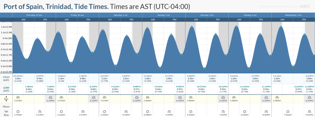
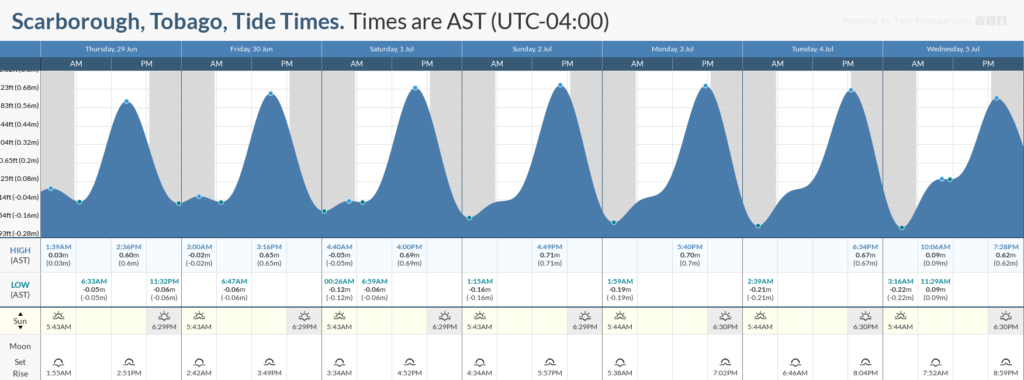
While no long-period swells are forecast, King Tides, or some of the highest high tides and lowest low tides of the year, will begin on Friday, which will increase the hazard potential during high tide periods through next week.
Saharan Dust levels are forecast to remain elevated through late Friday, June 30th, 2023, and again from Sunday, July 2nd, 2023, but briefly.
Through next week, swell periods are forecast between six and eleven seconds.
Possible Impacts
Saharan Dust concentrations are forecast to remain at elevated levels through late Friday and again on Sunday, affecting visibility and air quality.
Additionally, King Tides are forecast to begin on June 30th, 2023. While spring tides are higher than usual high tides and lower than usual low tides, King Tides are some of the highest high tides and lowest low tides for the year, which will increase the rip current threat. Rip currents are strong currents perpendicular to the shoreline that can carry even the strongest swimmers out to sea. With heavy rainfall forecast on Saturday and during the first half of next week, high tide periods may slow down runoff, enhancing chances of riverine flooding if modeled rainfall totals materialize.
The main marine impacts are likely from Monday, with an increase in winds and increased tidal range. These include coastal erosion; coastal flooding; localized disruptions of businesses; sea search and rescue disruptions; damage or loss of boats and fishing equipment; disruptions to marine recreation and businesses, and economic losses.
Forecast models have trended away from having the strongest winds move across T&T, keeping it north of the country. Stronger winds near T&T will result in higher waves, but it is important to note that the current sea state forecast is already at the higher end of what has been modeled for T&T.


