


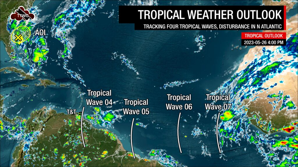
There are now four tropical waves between Trinidad and Tobago and the African Coast, with the closest wave moving across the country on Friday afternoon, as forecast. As we head into June, tropical waves are forecast to become more frequent, moving across T&T every two to three days.
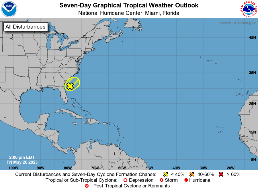
Meanwhile, in the North Atlantic near the southeastern United States, the National Hurricane Center is still monitoring a non-tropical area of low pressure for tropical cyclone development, but chances are low as it moves onshore over the weekend.
What you need to know
— Tropical Wave 04: The axis of this wave has been analyzed along 60W, moving west at approximately 15-20 knots (27-38 KM/H). Scattered showers and isolated thunderstorms have been noted with this wave across and east of T&T. It is forecast to continue affecting T&T today, Friday, May 26th, 2023, with trailing activity into the upcoming weekend.
— Tropical Wave 05: The axis of this tropical wave is located along 48W, moving west at 15 knots (27 KM/H). Scattered showers have been noted with this wave, and it is now forecast to move across T&T on Sunday, May 28th, 2023.
— Tropical Wave 06: The axis of this tropical wave is located along 38W, moving west at 15 knots (27 KM/H). No significant showers have been noted with this wave, and it is forecast to remain a fairly weak tropical wave as it nears the region, moving across T&T late Tuesday, May 30th, 2023, into Wednesday, May 31st, 2023.
— Tropical Wave 07: The axis of this tropical wave is located along 20W, moving west at 10 knots (18 KM/H). Scattered moderate to isolated strong convection have been noted on either side of the wave axis, mainly where this wave interacts with the Intertropical Convergence Zone (ITCZ). Forecast models indicate this wave is forecast to near the region by the end of next week into the weekend.
— AOI Near Southeastern US: The NHC is monitoring a non-tropical low-pressure system off the coast of the southeastern United States, producing disorganized showers and thunderstorms. While development appears unlikely, gusty winds, heavy rainfall, and dangerous surf and rip currents are forecast for portions of the Carolinas and Virginia. Development chances remain low.
— Hazards: Rainfall chances are set to increase from Friday through the weekend as convergence follows the passage of TW04 and TW05, and the nearby proximity to the ITCZ is forecast to support shower and thunderstorm activity. Though widespread severe weather or heavy rainfall is not expected, localized gusty winds and street flooding will be possible in heavy showers and thunderstorms.
— Development Concerns: Elsewhere across the Atlantic, tropical cyclone development is not expected, according to the National Hurricane Center.
Tropical Wave 04
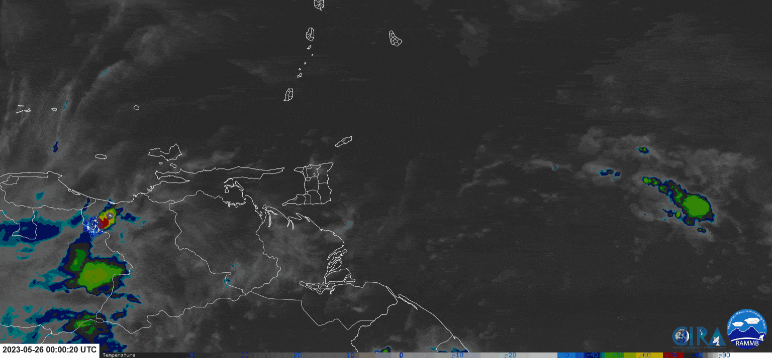
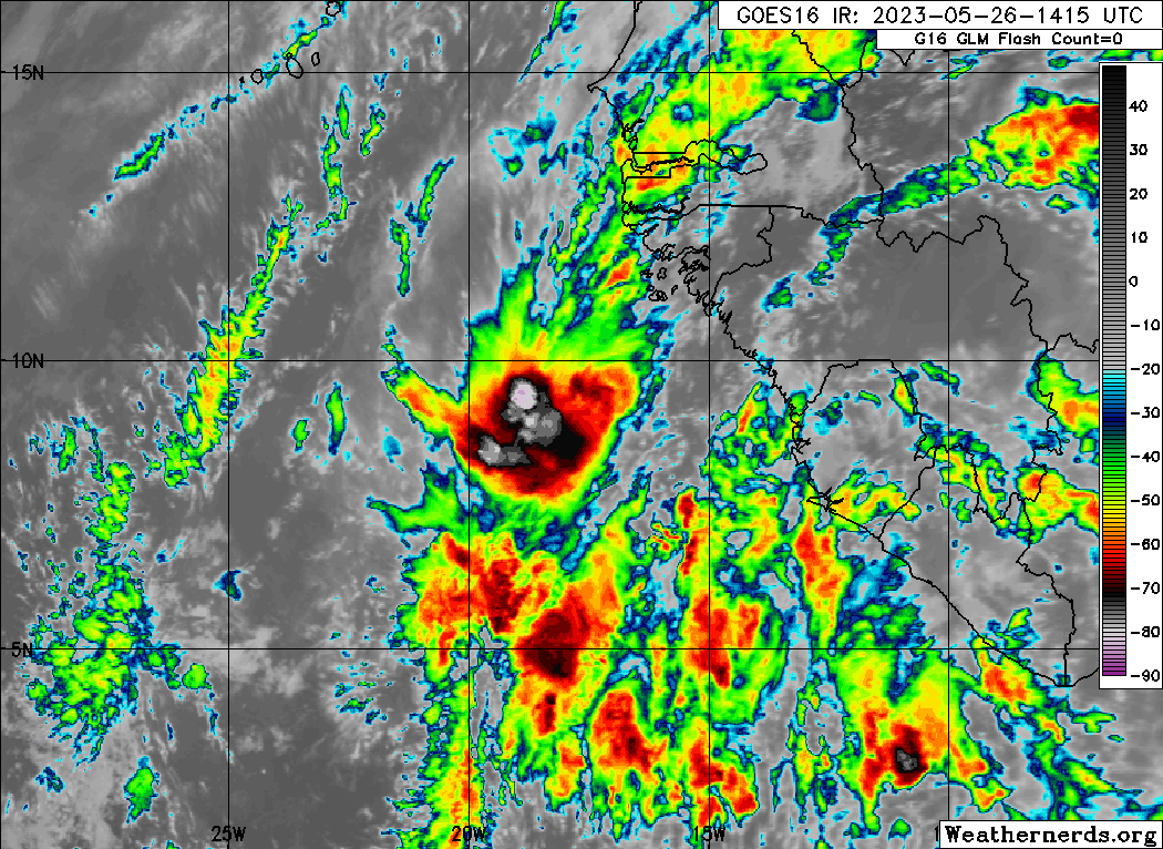
The fourth tropical wave analyzed as of 4:00 PM May 25th, 2023, is along 60W and south of 12N, moving west at 15 to 20 knots (27 to 38 KM/H). The wave is currently affecting Trinidad and Tobago, with the bulk of activity still east of the country. Scattered showers and thunderstorms have affected the country since early Friday, with additional showers and thunderstorms forecast overnight and through the weekend.
Across the wave axis, total precipitable water (a measure of atmospheric moisture) values are near 2.34 inches, but with relative humidity between 300mb to 850mb, around 80%, indicative of a very moist atmosphere. Wind shear remains moderate, up to 20 knots from the west. While an upper-level convergent environment is present across Trinidad and Tobago on Friday afternoon, suppressing shower/thunderstorm activity over the wave axis, a highly favorable upper-level divergent and low-level convergent environment is present, supporting showers and thunderstorms developing.
Specifically for T&T, as this tropical wave and associated activity move west, wind shear across Trinidad and Tobago is forecast to improve, with speeds between 10 to 25 knots still from the west. As a result, there is the potential for increased persisting showers/thunderstorms, but overall, stronger showers, thunderstorms, and heavy rainfall are forecast to remain offshore eastern Trinidad and Tobago with isolated heavy showers and thunderstorms along western and hilly areas. Additional details can be found in the weather forecast.
Tropical Wave 05

The fifth tropical wave for 2023 is located along 48W, south of 10N, moving west at 15 knots (27 KM/H). Scattered showers and cloudiness exist ahead of the wave axis between TW04 and TW05 between 7N and 12N.
Based on forecast models, this wave is forecast to eventually move across the Windwards on Sunday, May 28th, 2023. However, this wave is not forecast to be particularly strong, bringing any major rainfall to the country. Still, this wave is forecast to bring the ITCZ closer and even across the country on Sunday through the first half of Monday.
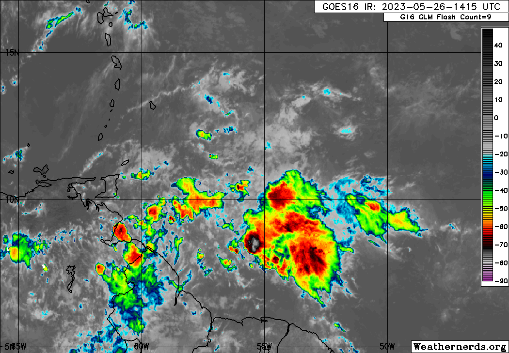
The axis of Tropical Wave 04 along 60W and Tropical Wave 05 along 48W on Friday, May 26th, 2023, with scattered moderate to isolated strong convection between both waves, east of Trinidad and Tobago. (Weathernerds.org)
Tropical Wave 06
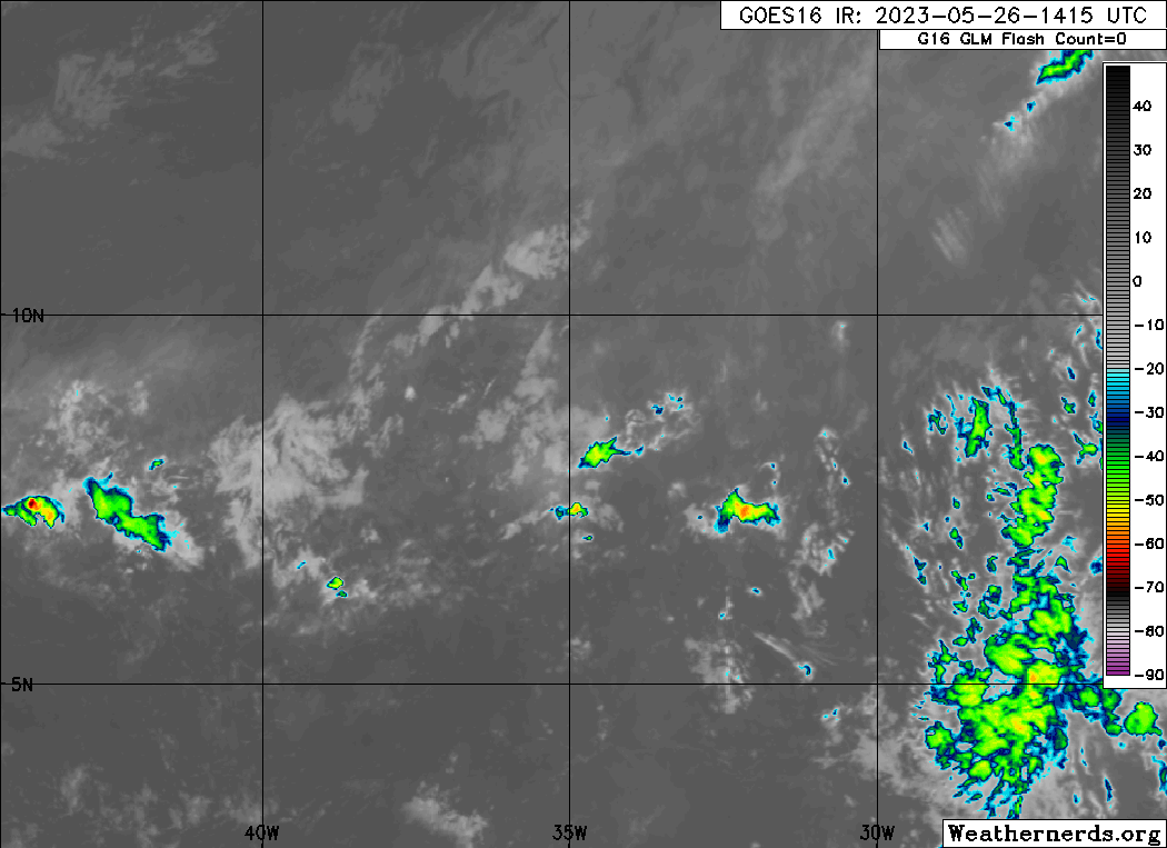
The sixth tropical wave for 2023 is located along 38W, south of 11N, moving west at 15 knots (27 KM/H). Little to no convection (showers and thunderstorms) are associated with this wave, with few showers developing following the wave axis.
This tropical wave is not forecast to be particularly strong or intense as it moves towards the Windwards, as it faces strong to very strong wind shear (up to 50 knots from the northwest).
Still, showers and thunderstorms are possible on Tuesday, drying out by Wednesday across the country.
Tropical Wave 07
The seventh tropical wave for 2023 has left the African coast with pulsing convection, mainly where the wave interacts with the Intertropical Convergence Zone. As of 4:00 PM, the axis of this tropical wave is located along 20W, moving west at 10 knots (18 KM/H).
Trade winds are forecast to decrease across the Atlantic next week, leading to weaker steering currents for this tropical wave. As a result, this tropical wave is forecast to slow down as it moves across the Atlantic Ocean, with forecast models showing the wave and associated moisture plume reaching across the Windwards by June 2nd, in tandem with a moderate to high concentration surge of Saharan Dust, which could weaken the wave.
However, longer-range forecast models show a deep plume of moisture moving across much of the Eastern Caribbean next weekend with a decrease in wind shear across the region. Additionally, the Eastern Caribbean will be on the western periphery of a high-pressure system located northwest, leading to enhanced low-level convergence.
Ultimately, there is still abundant time to monitor this wave as it moves across the Atlantic, with eventual impacts still over a week away.
Area of Interest Near SE United States

The National Hurricane Center (NHC) has been monitoring an area of disturbed weather north of the Bahamas and east of Florida for the last several days, giving it a low (10%) chance of tropical cyclone formation over the next 48 hours and seven days as of 2:00 PM Friday, May 26th, 2023.
In their latest Tropical Weather Outlook, the NHC says, “Disorganized showers and thunderstorms located near the southeastern United States coast are associated with a non-tropical low-pressure area and associated frontal boundary. The low is unlikely to become a subtropical or tropical cyclone since it is forecast to remain frontal while moving generally northward and inland over the Carolinas late Saturday or Sunday.”
They added that regardless of development, the system is likely to produce gusty winds and
dangerous surf and rip current conditions along portions of the southeastern United States late this week and into the weekend. In addition, they warn that heavy rainfall is expected in portions of the Carolinas and Virginias, with hazardous marine conditions expected over the coastal and offshore waters where gale and storm warnings are in effect.
This system poses no threat to Trinidad, Tobago, and the remainder of the Eastern Caribbean.
Not Every Tropical Wave Brings Severe Weather
Tropical waves vary in intensity as it travels westward across the Atlantic. This variability can be on the order of days to as short term as hours. Sometimes, you may see satellite imagery that shows heavy thunderstorms and deep convective activity east of Trinidad and Tobago during the late night and early morning, but by daybreak – nothing.
This is due to diurnal (daily) variations in convective showers whereby convection peaks overnight and wanes during the day for already occurring convective systems (i.e., not triggered by daytime heating).
Activity can be enhanced by its proximity to upper-level troughs and the ITCZ but can also be degraded by hostile upper-level conditions and Saharan Dust.


