


Long-period swells originating from a low-pressure system in the North Atlantic, just off the west coast of Africa, are moving toward the Lesser Antilles. These high-energy waves are forecast to affect T&T from early Saturday morning with potentially dangerous conditions for sea bathers and mariners into the new year.
What you need to know
— What is happening: Beginning early Saturday morning, swells with periods of up to 22 seconds are forecast to affect Trinidad and Tobago’s northern and eastern coastlines. Over the next seven days, swells are forecast to continue with decreasing swell periods, eventually affecting Trinidad’s sheltered, north-facing coastlines in the Gulf of Paria.
— What can we expect: Large, battering waves are possible along T&T’s northern and eastern coastlines, with choppy conditions in sheltered areas. Minor to moderate coastal erosion is possible. There is a high risk of rip currents along the country’s northern and eastern coastlines. The overall sea state in open waters is forecast to remain moderate through the alert period.
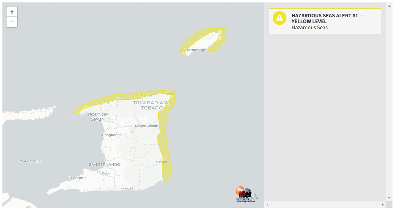
— Alerts/Watches/Warnings: A Hazardous Seas Alert (Yellow Level) goes into effect for northern and eastern Trinidad and Tobago from 2:00 AM Saturday, December 31st, 2022, and remains in effect through 12:00 PM (noon) Monday, January 2nd, 2023, from the Trinidad and Tobago Meteorological Service. There are no tropical storm or hurricane watches or warnings in effect for T&T at this time.
The Hazardous Seas Alert
The Trinidad and Tobago Meteorological Service issued a Hazardous Seas Alert (Yellow Level) on Friday at 12:01 PM. The alert goes into effect for northern and eastern Trinidad and Tobago from 2:00 AM Saturday, December 31st, 2022, and remains in effect through 12:00 PM (noon) Monday, January 2nd, 2023. Swells are forecast to propagate into the Gulf of Paria, affecting the north-facing coastlines of southwestern Trinidad over the weekend.
Trinidad and Tobago is not under any tropical storm watch or warning at this time.
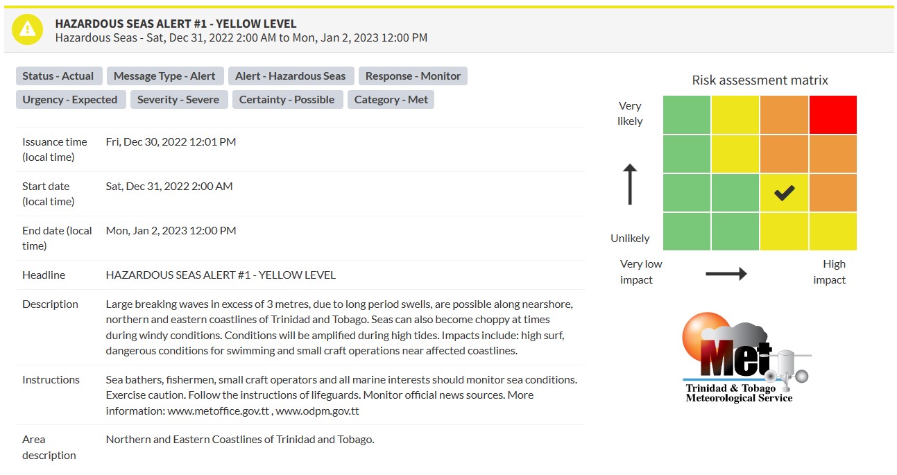
“Large breaking waves in excess of 3 metres, due to long period swells, are possible along nearshore, northern and eastern coastlines of Trinidad and Tobago. Seas can also become choppy at times during windy conditions. Conditions will be amplified during high tides. Impacts include high surf, dangerous conditions for swimming and small craft operations near affected coastlines,” according to the Trinidad and Tobago Meteorological Service.

The alert’s color indicates the event’s severity and probability of the event occurring. Currently, the alert level is Yellow. Unlike the typical yellow-level Hazardous Seas Alerts that have been issued in the past, certainty is possible for this event. This certainty level is lower than usual, ranking 2 out of 4, with 4 being the highest confidence. However, the impacts, unlike most yellow-level events, could be severe.
Large, battering waves in nearshore areas are forecast, producing dangerous conditions for all nearshore marine interests with a high risk of rip currents and beach erosion.
For a severe Hazardous Seas Alert, there is the potential for a loss of a single life or serious injuries; physical defenses are needed, major losses are possible in confined areas, income earning is impossible for several days, and several communities are affected where external help is needed for recovery.
The Met Office is advising sea bathers, fishermen, and small craft operators to carefully monitor coastal sea conditions and exercise caution along the coast. They added that the public should follow the instructions of lifeguards.


Forecast and Impacts
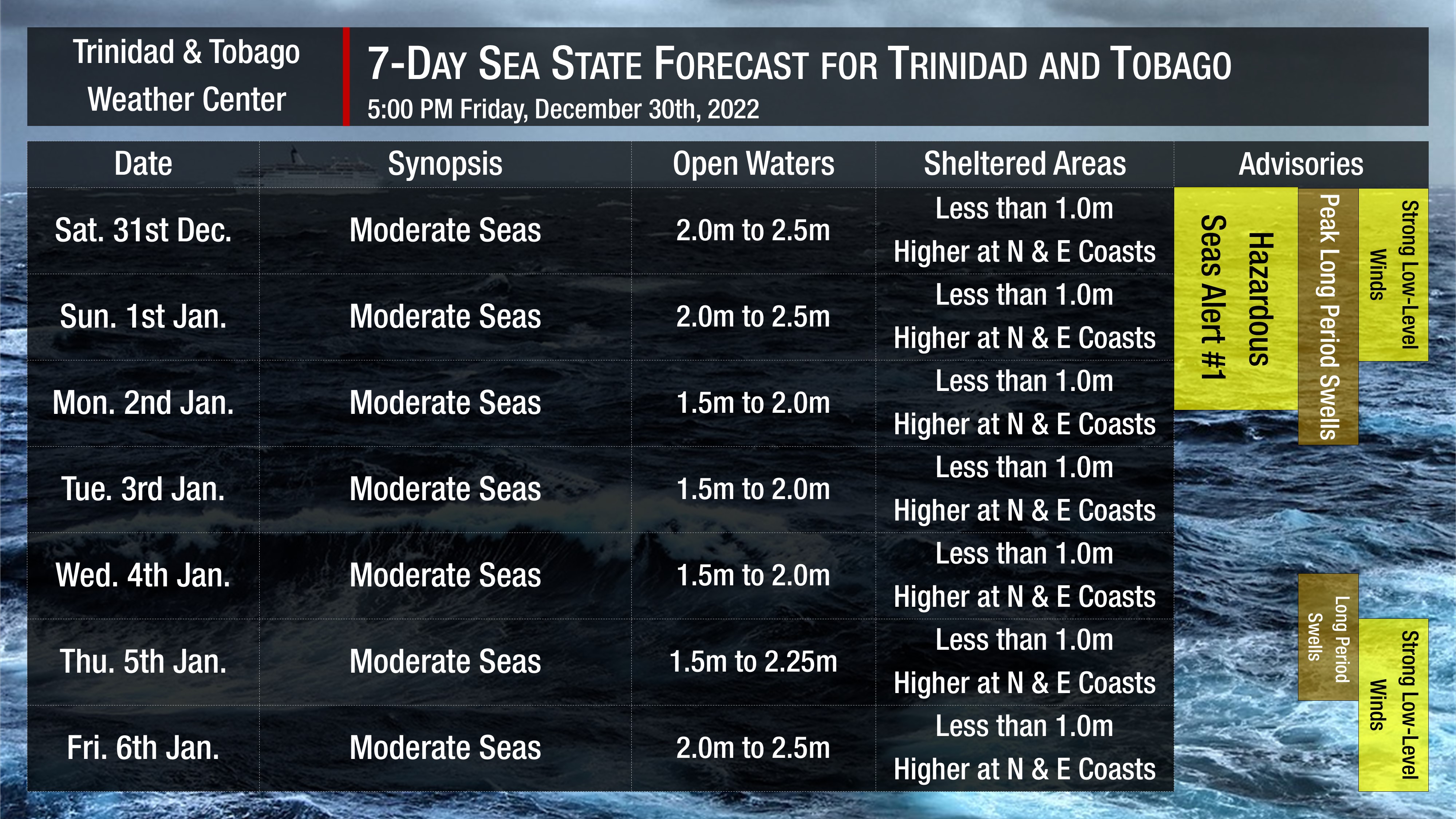
Over the next seven days, seas are forecast to be moderate into next week. Waves in open waters are forecast to be generally between 1.5 and 2.5 meters through the forecast period. However, in nearshore areas, particularly along the northern and eastern coastlines of Trinidad and Tobago, waves could exceed 3.0 meters. Elsewhere, in sheltered areas, waves are forecast to be less than 1.0 meters.
Swell periods are forecast to peak between 14 and 22 seconds between Saturday and Monday, diminishing between 9 and 15 seconds through the remainder of the forecast period.
Winds are forecast to be fresh to strong through next week, with sustained winds between 15 and 20 knots from the east to northeast. Gusts during this period are forecast to reach 30 knots, especially in the vicinity of brief showers.
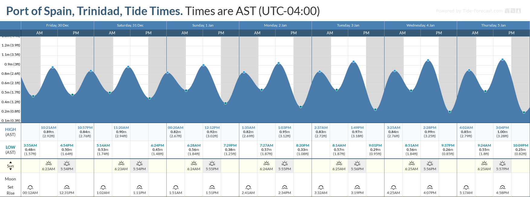
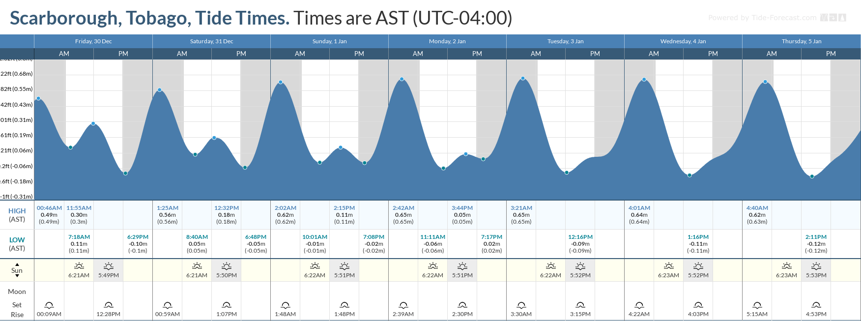
Unlike the prior Hazardous Seas event, which triggered the first-ever orange-level seas alert, spring tides are not expected. Still, during high tide periods, dangerous, breaking waves, beach erosion, and rip tides are all forecast to be amplified.
Saharan Dust is also forecast to remain at mild to moderate levels through the forecast period, marginally reducing visibility and air quality across Trinidad and Tobago.
Impacts from long-period swells and battering waves include the following:
- Coastal erosion;
- Coastal flooding;
- Localized disruptions of businesses;
- Sea search and rescue disruptions;
- Damage or loss of boats and fishing equipment;
- Disruptions to marine recreation and businesses
- Economic losses.
There is also the potential for loss of life and injuries. There is a very high risk of rip currents, which can carry even the strongest swimmers out to sea.
How to spot a rip current

Rip Currents
High surfs can knock spectators off exposed rocks and jetties. Breaking waves may occasionally impact harbors making navigating the harbor channel dangerous.
Saltwater will likely splash onto low-lying coastal roads such as Pigeon Point Road, the Guayaguayare Mayaro Road at the Guayaguayare Sea Wall, and the Manzanilla-Mayaro Road. Bays and beaches may become inundated, particularly along the northern coastlines of the country.
Coral reefs may experience increased stress and damage, in addition to localized beach erosion, particularly in areas where battering waves focus.

