


Tropical Wave 23 moved across the Lesser Antilles on Friday, with few showers and isolated thunderstorms predominantly affecting the northern Windwards and Leewards. A low-level to surface trough follows with another tropical wave, a surge of winds at low levels of the atmosphere, and the Intertropical Convergence Zone are all set to keep rainfall on tap through the weekend.
What you need to know
— Saharan Dust: Fluctuating Saharan Dust levels are forecast through Sunday, with a high-concentration surge arriving by Sunday afternoon into the evening. Generally, higher dust concentrations are forecast to remain north of T&T.
— Rainfall: Isolated to scattered showers and thunderstorms are forecast over the weekend through early Monday and from Wednesday. The wettest day is forecast to be Sunday. Over the next five days, 50 and 100 millimeters of rainfall is forecast across most of the country, with isolated totals up to 150 millimeters favoring southern Trinidad and localized areas of western and northern Trinidad.
— Hazards: The main hazards are localized street/flash flooding favoring the western half of Trinidad, with gusty winds up to and in excess of 45 KM/H accompanying heavy showers or thunderstorms. The chances for riverine flooding remain low at this time. Lightning will accompany thunderstorms.
— Alerts/Watches/Warnings: A High Wind Alert (Yellow Level) is in effect for Trinidad and Tobago from 8:00 PM Saturday, 30th July, 2022, through 8:00 PM Sunday, August 1st, 2022, from the Trinidad and Tobago Meteorological Service. There are no tropical storm or hurricane watches or warnings in effect for T&T at this time.
The Forecast
Saturday
SaturdaySunday
SundayMonday
MondayTuesday
TuesdayWednesday
WednesdayMarine: Through Wednesday, seas are forecast to be slight to moderate, with waves in open waters up between 1.0 and 2.0 meters. In sheltered areas, waves are forecast to be below 1.0 meter and occasionally choppy in the vicinity of heavy showers/thunderstorms.
Temperatures
Through the forecast period, the minimum low in Trinidad and Tobago is forecast to be between 23.0°C and 26.0°C.
Over the next five days, maximum highs across the country are forecast to be up to 33.0°C in Trinidad and 32.0°C in Tobago, with cooler maximum highs up to 31.0°C from Sunday through Monday and again on Wednesday across both islands due to increased cloud cover. In urbanized areas like Port of Spain, Scarborough, San Fernando, and Chaguanas, the maximum high temperatures could exceed 34.0°C on Saturday and Tuesday.
Forecast Impacts
Flooding
FloodingThere is a high chance of street and flash flooding, particularly across the western half of Trinidad. Chances for riverine flooding remain low as major rivers across the country are well within their banks.
Forecast Rainfall Totals
- Saturday: Between 15 and 25 millimeters of rainfall across both islands, trending higher across eastern and southern areas of Trinidad, as well as along western coastal Trinidad.
- Sunday: Between 15 and 35 millimeters of rainfall across both islands, trending higher across Trinidad with isolated totals between 50 and 75 millimeters, particularly in central and southern areas.
- Monday: Less than 20 millimeters of rainfall across the country, trending higher across southern Trinidad, with isolated totals between 50 and 75 millimeters.
- Tuesday: Less than 10 millimeters across the country, with isolated rainfall totals up to 25 millimeters favoring southern and western coastal Trinidad.
- Wednesday: Between 15 and 25 millimeters of rainfall across both islands, trending higher across northeastern areas of Trinidad and across Tobago.
Putting the rainfall forecast into context, rainfall rates in excess of 50 millimeters per hour or areas that receive in excess of 25 millimeters within an hour tend to trigger street flooding across the country or flash flooding in northern Trinidad. For riverine flooding to occur, a large area of the country (not just in highly localized areas of western coastal Trinidad) would have to record upwards of 75 millimeters within 24 hours, and rainfall would have to fall across major rivers’ catchment areas.
Strong Thunderstorms
Strong ThunderstormsThe chances of strong thunderstorms are medium, but activity will be short-lived. Funnel cloud development is possible through the next five days due to near calm to light and variable winds. The highest chances for funnel cloud/waterspout development exist along western coastal areas of both Trinidad and Tobago, as well as along southern and eastern coastal areas of Trinidad. If a funnel cloud touches down on a body of water, it becomes a waterspout; if it touches down on land, it becomes a tornado.
While abundant frequent cloud-to-ground lightning isn’t likely, lightning is expected in thunderstorm activity.
Gusty Winds
Gusty WindsWith wind gusts up to and in excess of 55 KM/H, whole trees are expected to be in motion, and there may be some inconvenience when walking against the wind gusts. Light outdoor objects may topple or become airborne such as garbage cans, potted plants, loose galvanize or construction material, and other outdoor furniture. Tents may jump. Older/weaker trees may fall, bringing down utility poles and lines.
Other Hazards
Saharan Dust will fluctuate over the next five days, occasionally reducing air quality and affecting visibility. Dust levels are forecast to increase by late Sunday.
Why I May Not/Will Not See Rainfall?
A frequent complaint is the forecast is wrong because I didn’t experience any rainfall. Scattered showers mean that you, individually, may experience some showers intermittently throughout the day, and there is a higher chance for this activity than isolated activity. Widespread showers mean that nearly all persons and areas may experience rainfall.
Isolated to scattered showers and thunderstorms are forecast on Saturday through early Monday and again from Wednesday.

Forecast Discussion
Tropical Waves (and other features) East of T&T: Based on the Tropical Analysis and Forecast Branch’s 18Z surface analysis on July 29th, 2022, as well as the latest satellite and model guidance:
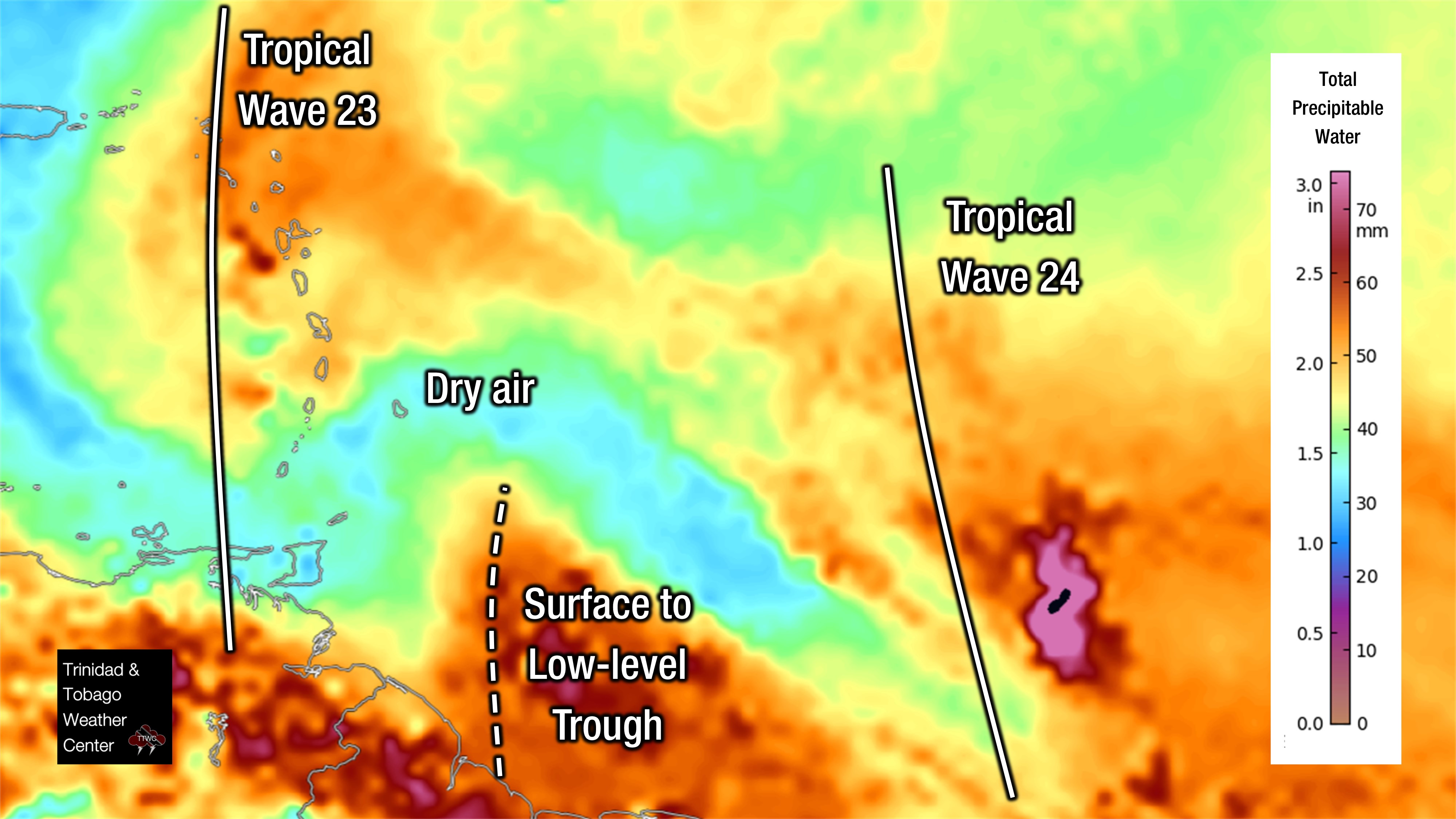
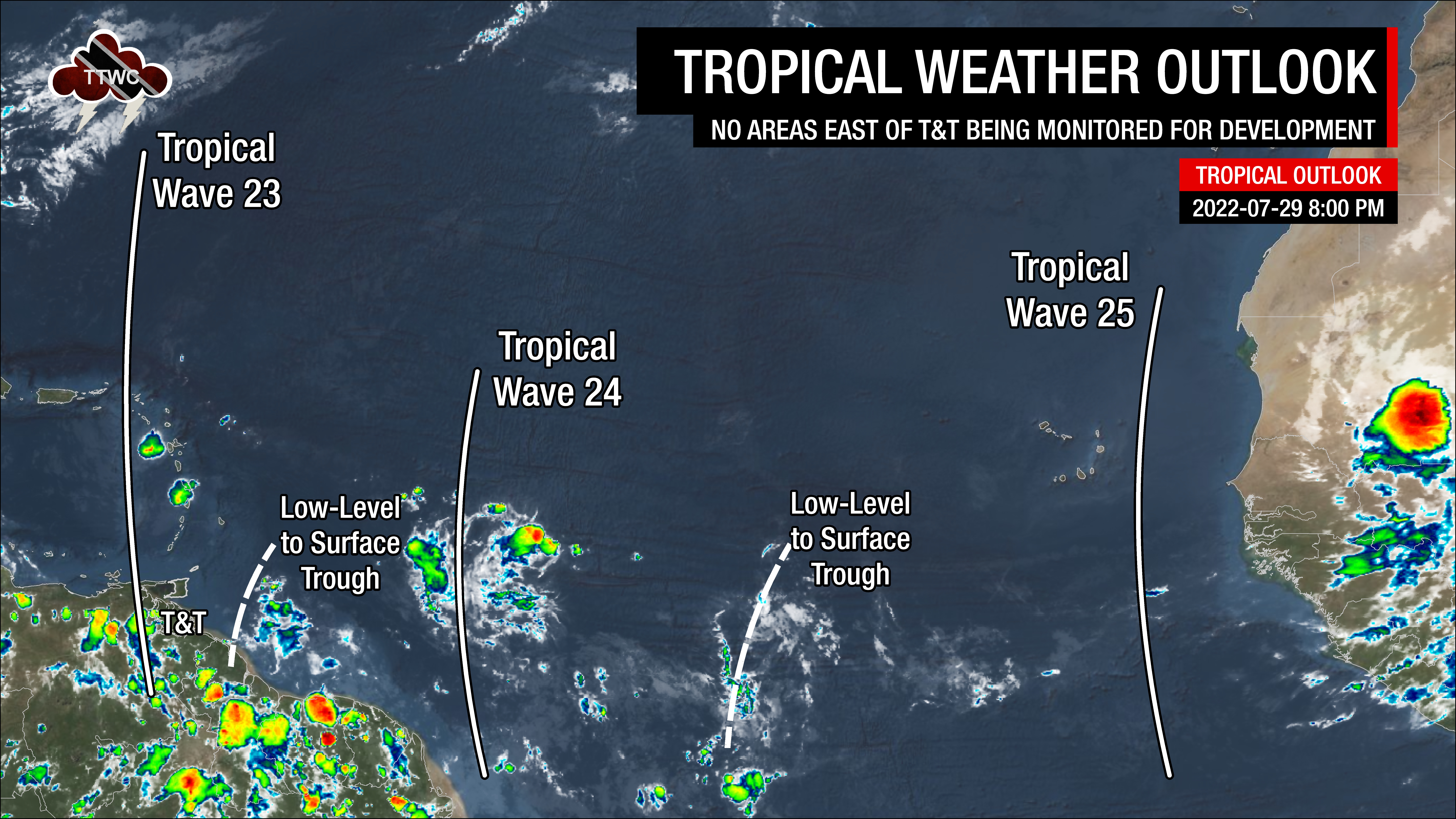
- The 23rd tropical wave for 2022 (TW23) is a large, elongated wave with the leading edge along 63°W, south of 22°N, moving west at 10-15 knots (18-28 KM/H). No significant showers or thunderstorms are noted near the wave due to abundant Saharan Dust. Still, isolated pockets of showers have been noted near the Leewards, where the highest moisture levels moved through on Friday.
- A surface to low-level trough is along 58°W, south of 12°N, moving west at 15-20 knots (28-37 KM/H). Scattered pockets of showers and isolated thunderstorms have been noted near the trough axis with abundant atmospheric moisture. This surface to low-level trough is forecast to begin affecting Trinidad and Tobago from 5:00 AM Saturday, July 30th, 2022.
- The 24th tropical wave for 2022 (TW24) is along 48°W, south of 22°N, moving west at 15-20 knots (28-37 KM/H). Scattered moderate convection is ongoing near the southern portion of the wave. This tropical wave is forecast to move across the region by late Saturday night into Sunday, ushering a surge of Saharan Dust by mid to late Sunday.
- Another surface to low-level trough is along 37/38°W, south of 12°N, moving west at 15-20 knots (28-37 KM/H). A cluster of showers and thunderstorms gradually dissipated near the well-defined trough axis on Friday. This trough is forecast to interact with the ITCZ as it moves across T&T on Wednesday, August 3rd, 2022.
- The 25th tropical wave for 2022 (TW25) is along 19°W, south of 20°N, moving west at 10-15 knots (18-28 KM/H). No deep convection is associated with this tropical wave due to dense Saharan Dust. Forecast models indicate this tropical wave will move across the Lesser Antilles by Thursday, August 4th, 2022.
On Friday, a dry and stable mid- to upper-level environment was present across Trinidad, Tobago, and the Southern Windwards Islands as dry air associated with Tropical Wave 23’s southern portion moved across the area. Still, Trinidad and, to a lesser extent, Tobago did experience increased cloudiness during the afternoon along western coastal areas due to localized climatic features – sea breeze convergence and daytime heating.
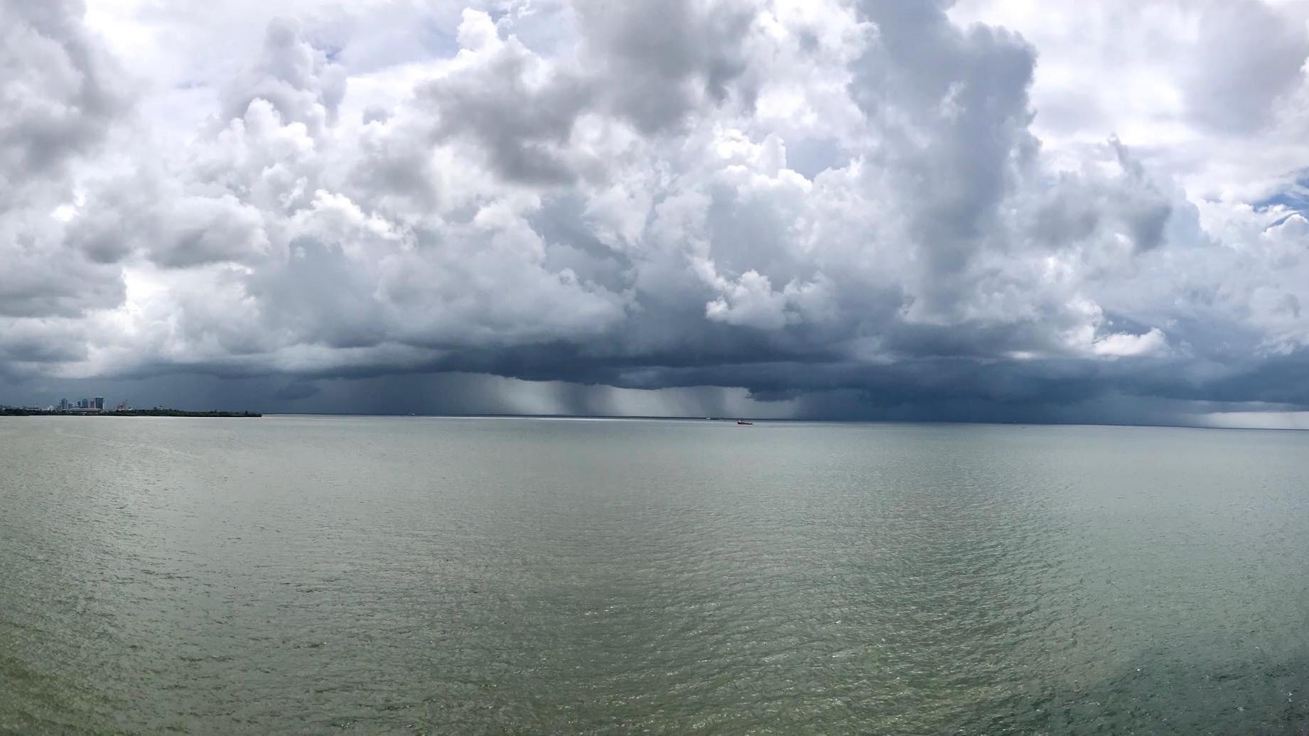
To the east, a fast-moving surface to low-level trough is approaching Trinidad and Tobago with scattered areas of cloudiness, showers, and isolated thunderstorms. Based on the current speed and trajectory as of Friday evening, activity from the trough is forecast to begin affecting the country from approximately 5:00 AM Saturday, July 30th, 2022, with unsettled weather through the day. A low-level jet is forecast to develop and persist through the weekend across the Windwards, enhancing showers and thunderstorms, as well as causing elevated surface winds and strong wind gusts to accompany showers and thunderstorms.
By nightfall on Saturday, TW24 will be approaching the area, losing its characteristic wind signature. However, strong convergence associated with the southern portion of the wave, as well as the presence of the Intertropical Convergence Zone (following the passage of the surface trough), will support scattered showers and thunderstorms into Sunday.
Following the passage of TW24, a surface to mid-level high-pressure system is forecast to rebuild across the region on Sunday. In tandem, a significant surge of Saharan Dust is forecast to begin moving across the region, including Trinidad and Tobago, from mid-Sunday. However, the Intertropical Convergence Zone is forecast to remain near and across Trinidad. While increasingly hazy and settled conditions are forecast across Tobago, Trinidad will remain under a moist and unstable atmosphere.
The ITCZ will continue to linger across Trinidad, drifting southward by Monday morning, with variably cloudy and hazy skies persisting across both islands due to the ITCZ’s proximity. However, increasingly stable conditions are forecast to build during the second half of Monday and through Tuesday.
By Wednesday, the second surface to low-level trough in the Atlantic is forecast to bring the ITCZ back across Trinidad and Tobago with a favorable atmosphere, supportive of showers and thunderstorms. This unsettled pattern is forecast to continue into the end of the upcoming week as TW25 moves across the region, even with the presence of Saharan Dust.


