


Saharan Dust is doing its best to quell rainfall across Trinidad and Tobago, but as Tropical Waves continue to move off the African coast and the Intertropical Convergence Zone (ITCZ) lingers nearby, occasionally wet days remain in the forecast.
What you need to know
— Saharan Dust: Moderate Saharan Dust is forecast to linger across the region through the next five days, with gradually decreasing concentrations toward the end of the week.
— Rainfall: The wettest days this week are forecast to be on Tuesday (today) and Friday into Saturday due to tropical waves and by the end of the week, the ITCZ as well.
— Hazards: The main hazards remain street/flash flooding, landslides in elevated areas, particularly across northern Trinidad, and gusty winds (up to and in excess of 45 KM/H), particularly on Thursday into Friday, accompanying heavy showers or thunderstorms. The chances for riverine flooding remain low at this time. Lightning will accompany thunderstorms.
— Alerts/Watches/Warnings: There are no alerts, watches, or warnings in effect for T&T from the Trinidad and Tobago Meteorological Service at this time. There are also no tropical storm or hurricane watches or warnings in effect for T&T.
The Forecast
Tuesday – Tropical Wave 15 & The ITCZ
Tuesday – Tropical Wave 15 & The ITCZWednesday
WednesdayThursday
ThursdayFriday – The ITCZ
Friday – The ITCZSaturday – ITCZ & Approaching Tropical Wave 16
Saturday – ITCZ & Approaching Tropical Wave 16Marine: Through Saturday, seas are forecast to be moderate with waves in open waters up to 2.0 meters, occasionally exceeding 2.0 meters from late Thursday. In sheltered areas, waves are forecast to be near or below 1.0 meter, becoming choppy by late Thursday into Friday, associated with increased low-level winds and rainfall activity.
Temperatures
Through the forecast period, the minimum low in Trinidad and Tobago is forecast to be between 24.0°C and 27.0°C.
Maximum highs across the country are forecast to be generally up to 32.0°C in Trinidad and Tobago. In urbanized areas like Port of Spain, Scarborough, San Fernando, and Chaguanas, the maximum high temperatures could exceed 32.0°C.
On Tuesday and Friday into Saturday, temperatures are forecast to be cooler due to increased cloud cover and anticipated rainfall.
Forecast Impacts
Flooding
FloodingThere is a high chance of street and flash flooding, mainly on Tuesday and Friday into Saturday. Chances for riverine flooding remain low as major rivers across the country are well within their banks.
Forecast Rainfall Totals
- Tuesday: Between 15 and 25 millimeters across the country, trending higher across southern and eastern areas of Trinidad and across Tobago with totals up to and in excess of 35 millimeters. In highly isolated areas, mainly across eastern Trinidad, totals upwards of 50 millimeters are forecast. Note that the GFS model, which has been more reliable with precipitation forecasts, shows widespread totals of 30+ mm of rainfall across Trinidad, with isolated pockets of 50+ mm across southern Trinidad. If these totals materialize, Trinidad may see impactful street and flash flooding on Tuesday. However, the GFS run remains an outlier at this time, and our forecast is more conservative for now.
- Wednesday: Less than 10 millimeters of rainfall across the country, trending higher across eastern areas of Trinidad, as well as southern coastal locations.
- Thursday: Less than 10 millimeters of rainfall across the country, trending higher across eastern areas of Trinidad. Across southeastern Trinidad, isolated totals up to 15 millimeters are possible.
- Friday: Across the western half of Trinidad, between zero and 15 millimeters of rainfall is forecast, with isolated totals exceeding 25 millimeters in thunderstorms or heavy/violent shower activity. Across the eastern half of Trinidad, isolated southern coastal areas, and across Tobago, rainfall totals between 15 and 25 millimeters are forecast, with isolated totals up to 35 millimeters possible.
- Saturday: Across the western half of Trinidad, between zero and 15 millimeters of rainfall is forecast, with isolated totals exceeding 25 millimeters in thunderstorms or heavy/violent shower activity. Across the eastern half of Trinidad, isolated southern coastal areas, and across Tobago, rainfall totals between 15 and 25 millimeters are forecast, with isolated totals up to 35 millimeters possible.
Putting the rainfall forecast into context, rainfall rates in excess of 50 millimeters per hour or areas that receive in excess of 25 millimeters within an hour tend to trigger street flooding across the country or flash flooding in northern Trinidad. For riverine flooding to occur, a large area of the country (not just in highly localized areas of western coastal Trinidad) would have to record upwards of 75 millimeters within 24 hours, and rainfall would have to fall across major rivers’ catchment areas.
Strong Thunderstorms
Strong ThunderstormsWith minimal to no wind shear, a highly moist atmosphere, and light to moderate low-level winds, there is a low to medium chance of a strong thunderstorm on Tuesday. Funnel cloud development is possible, particularly on Friday. If a funnel cloud touches down on a body of water, it becomes a waterspout; if it touches down on land, it becomes a tornado. Frequent cloud-to-ground lightning will be possible in thunderstorm activity.
Increasing wind shear and a drier low to mid-level environment are forecast to limit strong thunderstorm development by Wednesday into the weekend.
Gusty Winds
Gusty WindsWith wind gusts up to and in excess of 45 KM/H, whole trees are expected to be in motion, and there may be some inconvenience when walking against the wind gusts. Light outdoor objects may topple or become airborne such as garbage cans, potted plants, loose galvanize or construction material, and other outdoor furniture. Tents may jump. Older/weaker trees may fall, bringing down utility poles and lines.
Other Hazards
Saharan Dust will remain across the region through the forecast period, reducing air quality and affecting visibility.
Why I May Not/Will Not See Rainfall?
A frequent complaint is the forecast is wrong because I didn’t experience any rainfall. Scattered showers mean that you, individually, may experience some showers intermittently throughout the day, and there is a higher chance for this activity than isolated activity. Widespread showers mean that nearly all persons and areas may experience rainfall.
Isolated to scattered rainfall is forecast over the next five days.

Forecast Discussion
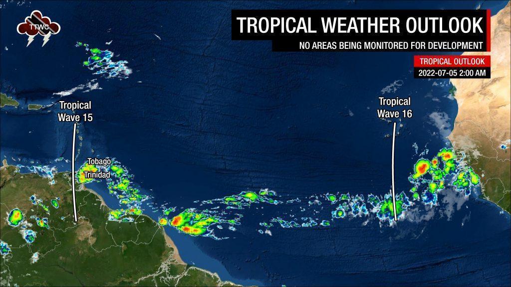
Tropical Waves East of T&T: Based on the Tropical Analysis and Forecast Branch’s 00Z surface analysis on July 5th, 2022, as well as the latest satellite and model guidance:
- The 15th tropical wave for 2022 (TW15) is along 62°W, south of 22°N, moving west at 15 knots (27 KM/H). On Monday night, this wave moved across Trinidad and Tobago and the remainder of the Lesser Antilles. Scattered moderate convection is ongoing behind the wave axis, mainly east of Trinidad and Tobago.
- The 16th tropical wave for 2022 (TW16) is along 25°W, south of 18°N, moving west at 15 knots (27 KM/H). This wave is forecast to move across Trinidad and Tobago on Saturday, July 9th, 2022, into Sunday, June 10th, 2022. Scattered moderate convection has been observed near the southern portion of the wave axis, while dense Saharan Dust limits convection elsewhere.
Showers and isolated thunderstorms have begun to affect Trinidad and Tobago early Tuesday morning associated with the passage of Tropical Wave 15 on Monday, July 4th, 2022, which dragged the ITCZ closer to the country. The strongest activity remains east of Trinidad and Tobago, with light to moderate rain spreading across parts of the country, while isolated heavy showers and thunderstorms favor eastern Trinidad.
Over the next 18 hours, a highly favorable mid- to upper-level atmosphere is forecast to support heavier showers and thunderstorms across T&T under a low-shear and high-moisture environment. On Tuesday morning, strong upper-level divergence and favorable low-level convergence were noted across Trinidad and Tobago. All of these ingredients coming together results in elevated chances for showers and thunderstorms through Tuesday night.
By Wednesday, a high-pressure ridge is set to return across T&T with a surge of Saharan Dust drying out the mid to low-level atmosphere, quelling rainfall chances until Friday when the ITCZ returns. On Wednesday through Thursday, wind shear is forecast to increase, keeping heavier rainfall activity localized to the East Coast while moisture remains capped to the lowest levels of the atmosphere.
By Friday, wind shear decreases somewhat, and moisture levels increase as the ITCZ nears the country. Additionally, low-level winds increase to 25 knots, which leads to breezy/windy conditions near the surface and gusty winds accompanying showers/thunderstorms. Marginally favorable atmospheric conditions will support isolated thunderstorm activity, with scattered showers forecast from Friday through Sunday due to the ITCZ and forecast passage of Tropical Wave 16.


