The 2022 Wet Season is off to a busy start, with four tropical waves moving across Trinidad and Tobago in just under two weeks since the official declaration on May 16th, 2022.
This year, the Trinidad and Tobago Meteorological Service (TTMS) has issued a “Flood Potential Outlook” as part of their overall Wet Season climate outlook, marking the second instance of such a product.
Thorugh the next six months, they are forecasting accumulated rainfall totals from 1300 millimeters in most areas of Tobago and areas along the west coast of Trinidad. Higher rainfall accumulations near 3000 millimeters in northeast Trinidad, in the vicinity of Sangre Grande, Vega De Oropouche, Plum Mitan, and environs are also forecast.
The Met Office indicates that flooding is expected to worsen and expand across the country as the 2022 Wet Season progresses.
According to the TTMS, there is an enhanced flood risk potential across the entire Wet Season this year, with the Caroni, North Oropouche, and South Oropuche river basins the most at risk. Areas not indicated in the following maps also have flood risks according to the TTMS but not as high as the ones singled out.
High Flood Risk Potential – 21 Communities
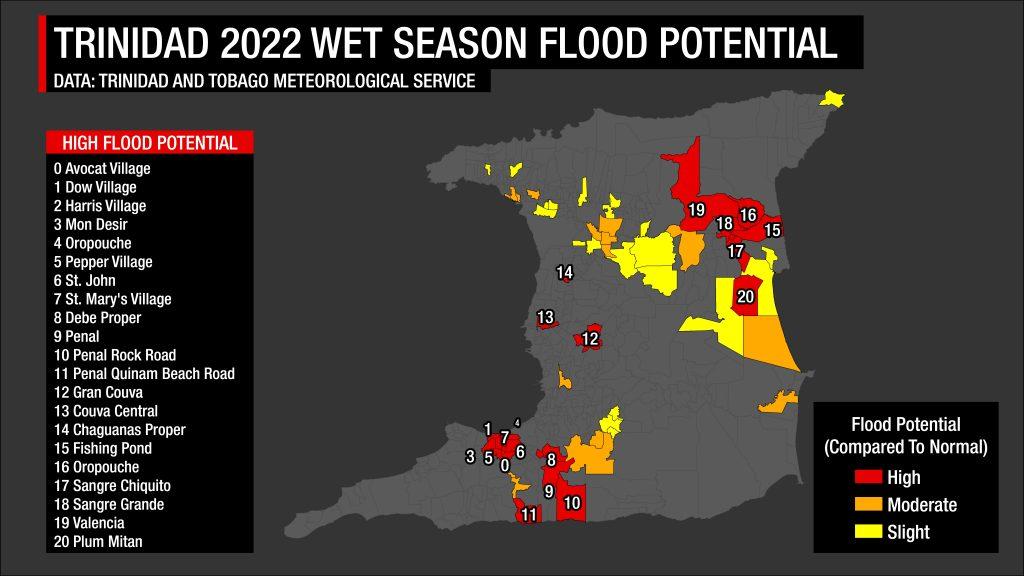
Based on the Met Office’s analysis, the following communities have a much higher than normal flood potential:
- Avocat Village
- Dow Village
- Harris Village
- Mon Desir
- Oropouche
- Pepper Village
- St. John
- Penal Rock Road
- Penal Quinam Beach Road
- Gran Couva
- Couva Central
- St. Mary’s Village
- Debe Proper
- Penal
- Chaguanas Proper
- Fishing Pond
- Oropouche
- Sangre Chiquito
- Sangre Grande
- Valencia
- Plum Mitan
Moderate Flood Risk Potential – 16 Communities
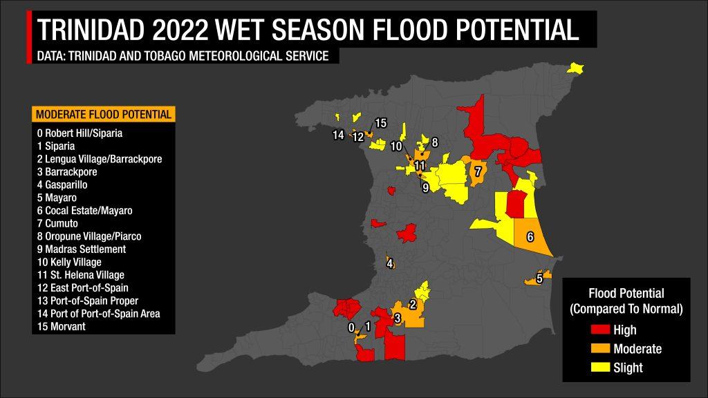
Based on the Met Office’s analysis, the following communities have a moderately higher than normal flood potential:
- Robert Hill/Siparia
- Siparia
- Lengua Village/Barrackpore
- Barrackpore
- Gasparillo
- Mayaro
- Cocal Estate/Mayaro
- Cumuto
- Oropune Village/Piarco
- Madras Settlement
- Kelly Village
- St. Helena Village
- East Port-of-Spain
- Port-of-Spain Proper
- Port of Port-of-Spain Area
- Morvant
Slight Flood Risk Potential – 44 Communities
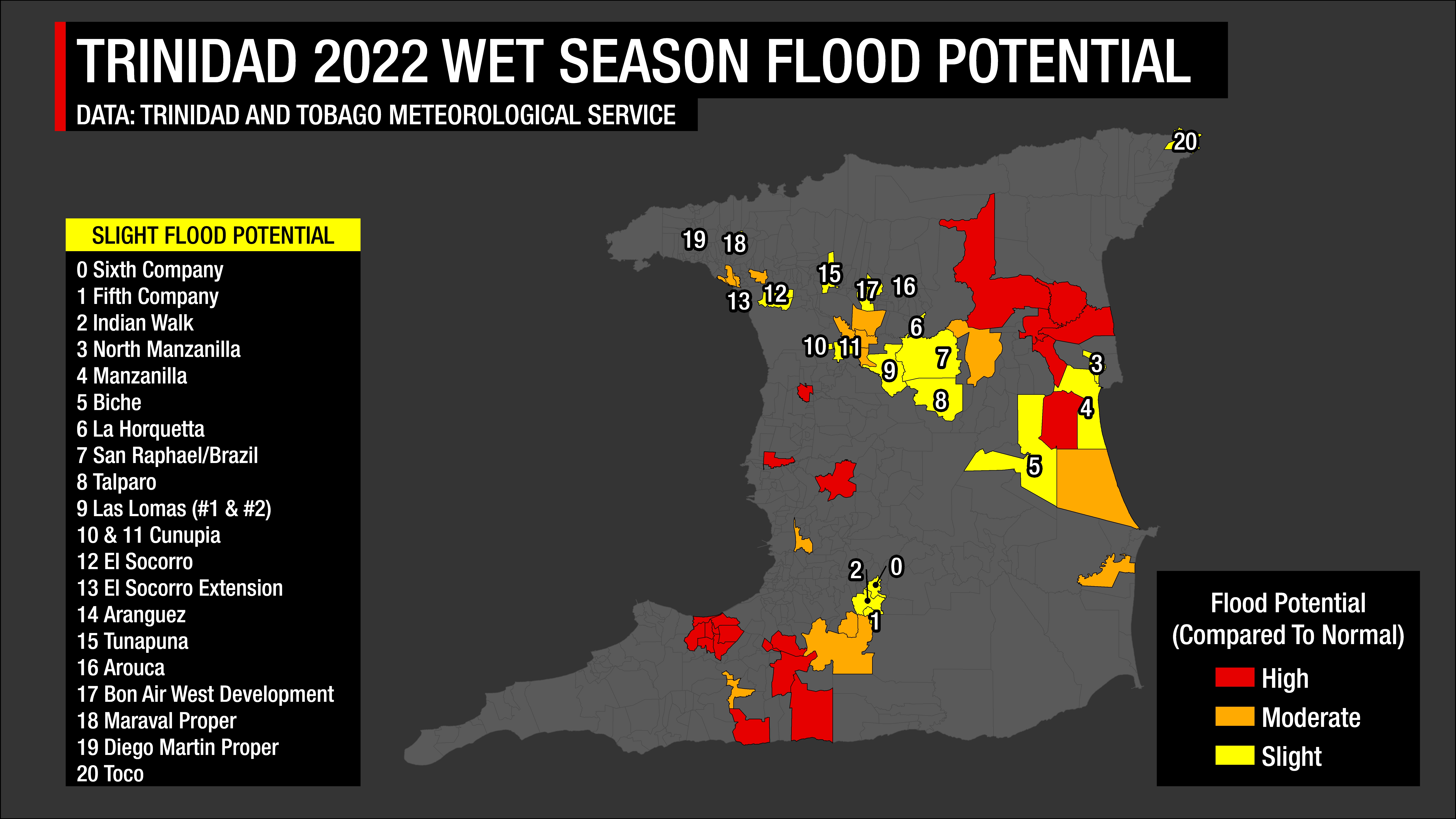
Across Trinidad, 20 communities met the Met Office’s threshold for a slightly higher than normal flood potential:
- Sixth Company
- Fifth Company
- Indian Walk
- North Manzanilla
- Manzanilla
- Biche
- La Horquetta
- San Raphael/Brazil
- Talparo
- Las Lomas (#1 & #2)
- Cunupia
- El Socorro
- El Socorro Extension
- Aranguez
- Tunapuna
- Arouca
- Bon Air West Development
- Maraval Proper
- Diego Martin Proper
- Toco
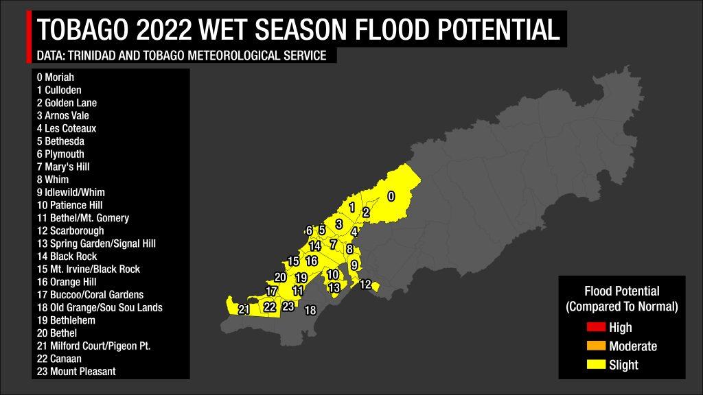
In Tobago, only communities with slightly above normal flood potential were indicated by the TTMS, totaling 24:
- Moriah
- Culloden
- Golden Lane
- Arnos Vale
- Les Coteaux
- Bethesda
- Plymouth
- Mary’s Hill
- Whim
- Idlewild/Whim
- Patience Hill
- Bethel/Mt. Gomery
- Scarborough
- Spring Garden/Signal Hill
- Black Rock
- Mt. Irvine/Black Rock
- Orange Hill
- Buccoo/Coral Gardens
- Old Grange/Sou Sou Lands
- Bethlehem
- Bethel
- Milford Court/Pigeon Pt.
- Canaan
- Mount Pleasant
When can we expect to see most floods?
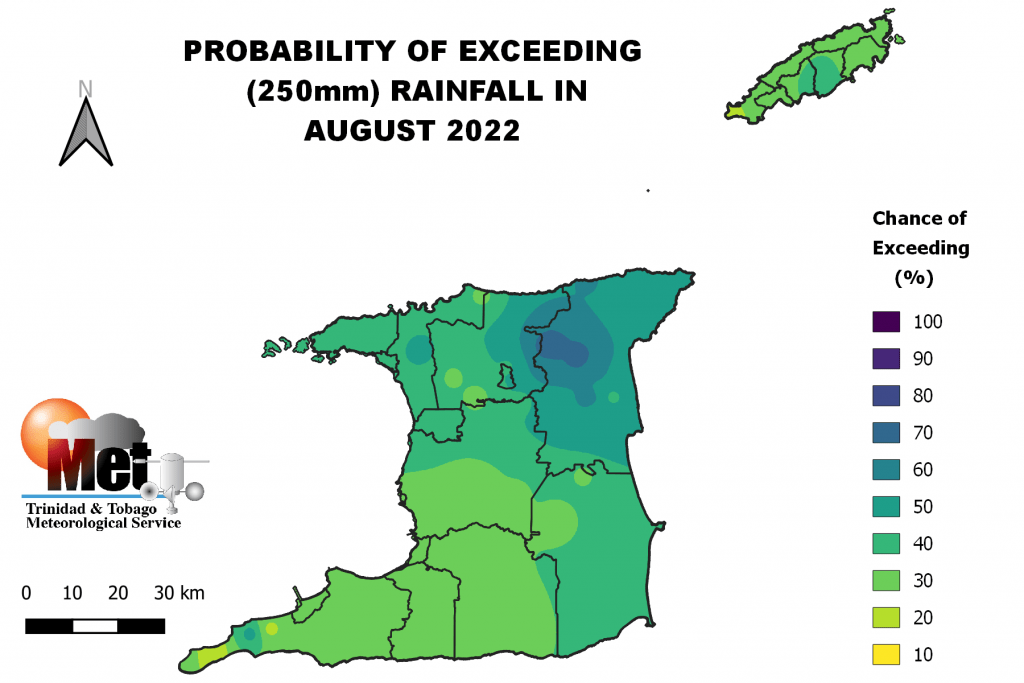
August is the wettest month of the year climatologically for Trinidad. For 2022, the chances of rainfall exceeding the monthly threshold for flooding (250 millimeters of rainfall accumulation) are high, according to the TTMS.
Their outlook shows a 20% to 50% chance of rainfall accumulation reaching and exceeding 250 millimeters, with the highest chances near Sangre Grande and its environs.
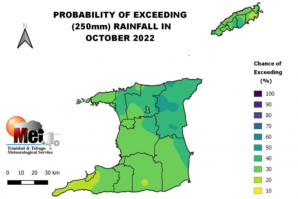
Meanwhile, October is the most flood-prone month with high-impact flood events. Like August, the chances of monthly accumulated rainfall exceeding the flood threshold are high, according to the TTMS.
There is a 14% to 40% chance for October’s rainfall to reach or exceed 250 millimeters across most areas of the country, with higher chances across northeastern Trinidad. This area is generally the wettest area of the country.


