


The 2022 Wet Season has begun for Trinidad and Tobago. For the next six months, Trinidad and Tobago will experience periods of rainfall associated with tropical waves, the Intertropical Convergence Zone, and even tropical cyclones. All the rainfall won’t arrive at once, but here’s what you should know for the next several months.
A slower than usual start to the 2022 Wet Season Forecast
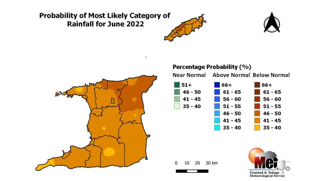
The Trinidad and Tobago Meteorological Service (TTMS) is forecasting below-average rainfall totals across much of the country for June 2022 in their updated outlook, issued on May 23rd, 2022.
In the latest outlook, the TTMS says that there is a 40% to 50% chance for below-normal rainfall in June for Trinidad and Tobago.
June is the second wettest month of the year for Trinidad, and the fifth wettest month for Tobago, with an average (1991-2020) monthly rainfall of 243.3 millimeters at Piarco, Trinidad, and 157.3 millimeters at Crown Point, Tobago.
In the last 41 years (1981-2021), the driest June recorded 113.1 millimeters at Piarco and 50.3 millimeters at Crown Point, in 2009 and 1981, respectively. The wettest June in the same period recorded 457.1 millimeters at Piarco in 1983 and 377.4 millimeters at Crown Point in 1992.
Read More

TTMS: June Likely To Bring Below-Average Rainfall To T&T
A wetter than usual season expected
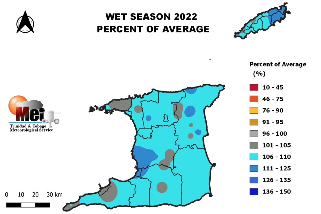
The 2022 Wet Season is forecast to end with above-average rainfall totals across most of the country. As we progress through the remainder of 2022, rainfall is expected to increase across the country. Overall, probabilities are greater than 40% for above-normal accumulated rainfall totals across Trinidad and Tobago for the 2022 Wet Season.
During the first half of the Wet Season, there is a greater than 45% chance for near-normal rainfall totals from June through August. From July through September, however, there is a greater than 40% chance of near-normal rainfall. There is a greater than 50% chance for above-normal rainfall totals by the August to October period. By the end of the year, from September to November, very high chances exist for above-normal rainfall.
The TTMS is forecasting August, October, and November to be the year’s wettest months.
“Volatile & Erratic”
The TTMS describes this year’s Wet Season as “volatile and erratic.” Wet Season rains have been consistent over a large area in the past. However, the Met Service has noted that more of T&T’s rainfall is coming in extremely heavy rainfall days, and 2022 is forecast to be no exception.
For 2022, there is a 58% chance for an above-normal number of heavy rainfall days (days with rainfall equal to or exceeding 25 millimeters). The country is likely to get 16-20 heavy rainfall days during the season. There is also a 37% chance for above-normal, extremely heavy rainfall days where rainfall reaches or exceeds 50.0 millimeters. The Met Office is also forecasting the country is likely to get 4 to 10 extremely heavy rainfall days, with at least two likely to produce in excess of 3 inches or 75 millimeters of rainfall.
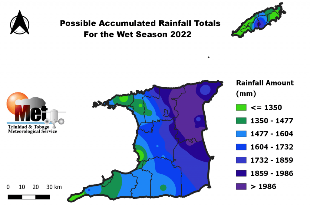
Thorugh the next six months, they are forecasting accumulated rainfall totals from 1300 millimeters in most areas of Tobago and areas along the west coast of Trinidad. Higher rainfall accumulations near 3000 millimeters in northeast Trinidad, in the vicinity of Sangre Grande, Vega De Oropouche, Plum Mitan, and environs are also forecast.
The Wet Season usually produces 102 to 106 wet days (days with rainfall greater than 1 millimeter). This year is likely to get a slight increase in the number of wet days, with 110 to 122 wet days most likely.
Keeping with the extreme theme, the Met Office’s outlook is forecasting at least four 5-day wet spells, with 5-day totals exceeding 80 millimeters of rainfall, and at least two of the 5-day wet spells are likely to exceed 100 millimeters. The TTMS adds that there is also a high chance for at least six 3-day wet spells, with 3-day totals exceeding 50 millimeters, and at least three of these wet spells are likely to produce above 80 millimeters of rainfall.
High flood risk potential
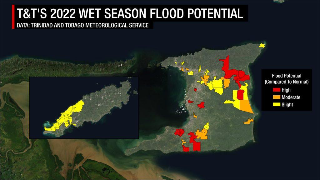
The Met Office indicates that flooding is expected to worsen and expand across the country as the 2022 Wet Season progresses.
According to the TTMS, there is an enhanced flood risk potential across the entire Wet Season this year, with the Caroni, North Oropouche, and South Oropuche river basins the most at risk. The Met Office has singled out 81 communities across T&T with elevated flood risk for the 2022 Wet Season.
Read More

2024 Wet Season: Higher-than-usual Flood Potential In 181 Communities
Warmer than average temperatures expected
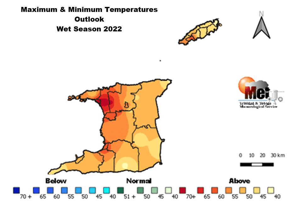
The (TTMS) is forecasting yet another Wet Season with above-average temperatures. For the 2022 Wet Season, the TTMS says there is a 45% chance for maximum day temperatures and minimum nighttime temperatures to be above average.
In Trinidad and Tobago, the local heat season has its peak during August through October, and the TTMS is forecasting maximum temperatures to reach or exceed 34.0°C during this time. There are also elevated chances for short-duration hot spells and “heat surges” where maximum temperatures reach or exceed 34.0°C during September and early October.
Read More

2022 Wet Season: More Hot Temperatures
What should you do?
- Strengthen community coordination with disaster management personnel.
- Persons living in flood risk areas should quicken their flood planning and preparedness efforts.
- Purchase emergency supplies, pack a grab and go-bag with clothes and essentials, and have these on standby.
- Get acquainted with your flood-prone areas and shelter locations and become sand-bag ready.
- Develop an evacuation plan that outlines the safety of family members and pets.
- Update contact information for the local disaster officials and other emergency services.


