


Tropical Storm Gonzalo Key Messages:
– Watches & Warnings: Tropical Storm Warnings are in effect for Tobago, Grenada, and its dependencies (according to NaDMA Grenada), St. Lucia, St. Vincent and the Grenadines, and Barbados. Hurricane Watches have been discontinued for Barbados and St. Vincent and the Grenadines. An Adverse Weather Alert is in effect for Trinidad.
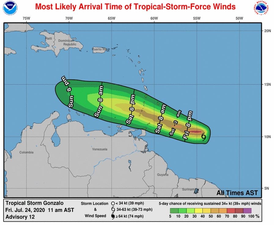
– Track: The track of Tropical Storm Gonzalo has shifted south and west towards Tobago. The core of Gonzalo is forecast to move across Trinidad and Tobago on Saturday, clipping Northeastern Tobago. The NHC is forecasting the center of the system to move north of Tobago, but further southward adjustments are anticipated. Activity is forecast to begin across Tobago late Friday night and across Trinidad by Saturday afternoon. Peak activity is expected late Saturday morning through Saturday afternoon across both islands.
– Intensity: There remains great uncertainty in the forecast intensity of this tropical storm. Gonzalo is forecast to remain a tropical storm but weaken as it nears landfall or passage across T&T. Across Trinidad, wind gusts in excess of 65 KM/H are likely in heavier showers or thunderstorms. Across Tobago, wind gusts in excess of 85 KM/H are expected. An aircraft reconnaissance flight is investigating Gonzalo this afternoon.
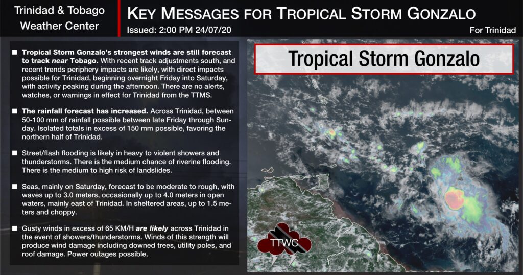
– Rainfall: As of Friday afternoon, direct and indirect impacts are forecast, with the overall forecast rainfall totals increased. Slight adjustments in the track may have significant changes in the rainfall forecast. Generally, between 50-100 millimeters of rainfall are forecast Friday through Sunday, with isolated totals in excess of 150 millimeters in areas of persisting heavy rainfall and thunderstorm activity, mainly across northern, eastern Trinidad and Tobago.
– Flooding: Street flooding and flash flooding in heavy to violent showers and thunderstorms are likely. There is a medium chance of riverine flooding.
– Landslides: There is a medium to high risk of landslides across Trinidad and a very high risk across Tobago.
– Seas: Seas are forecast to deteriorate on Friday night, with waves up to 2.5 meters, occasionally up to 3.0 meters into Saturday. Mainly on Saturday, forecast to be moderate to rough, with waves up to 3.0 meters, occasionally very rough, up to 4.0 meters in open waters. In sheltered areas, up to 1.5 meters and choppy.

NHC: Gonzalo To Affect Windwards on Saturday

The National Hurricane Center, as of 2:00 PM, continues to issue advisories on Tropical Storm Gonzalo, 1,170 KM east of the Windward Islands.
At 2:00 PM AST, the center of Tropical Storm Gonzalo was located by an Air Force Reserve Hurricane Hunter aircraft near latitude 9.9 North, longitude 54.8 West. Gonzalo is moving toward the west near 18 MPH (30 KM/H). A general westward to west-northwestward motion is expected during the next couple of days. On the forecast track, the center of Gonzalo will approach the southern Windward Islands tonight and then move across the islands on Saturday and over the eastern Caribbean Sea on Sunday.
The Hurricane Hunter aircraft has not yet completed its survey of Gonzalo, but preliminary data indicate that maximum sustained winds are near 45 mph (75 km/h) with higher gusts. There is considerable uncertainty in the intensity forecast, but some strengthening is possible during the next day or so before Gonzalo reaches the southern Windward Islands. Weakening is expected after Gonzalo moves into the Caribbean Sea, and the cyclone is expected to dissipate by the middle of next week.
Gonzalo is a small tropical cyclone. Data from the reconnaissance aircraft indicate that tropical storm-force winds extend outward up to 35 miles (55 KM) from the center. That’s approximately the distance from Sangre Grande to Chaguaramas in Trinidad. The most recent minimum central pressure reported by the Hurricane Hunter plane was 1008 millibars.
Hazards Affecting Land
WIND: Tropical storm conditions are expected within portions of the Tropical Storm Warning area on Saturday.
RAINFALL: Gonzalo is expected to produce total rain accumulations of 2 to 5 inches (50 to 125 mm), with isolated maximum amounts of 8 inches in Barbados and the Windward Islands through Sunday night. Gonzalo is also expected to produce total rain accumulations of 2 to 4 inches (50 to 100 mm) in Trinidad and Tobago, as well as 1 to 2 inches (25 to 50 mm) over northeastern Venezuela. Rainfall in Barbados and the Windward Islands could lead to life-threatening flash floods.
Watches & Warnings

The government of Barbados has canceled the Hurricane Watch for Barbados and St. Vincent and the Grenadines.
A Tropical Storm Warning is in effect for:
- Barbados
- St. Vincent and the Grenadines
- St. Lucia
- Grenada and its dependencies (based on an update from NaDMA Grenada)
UPDATE: A TROPICAL STORM WARNING IS IN EFFECT FOR TOBAGO.
A Tropical Storm Warning means that tropical storm conditions are expected somewhere within the warning area within 24 to 36 hours.
Interests elsewhere in the Windward Islands should monitor the progress of this system.

What We Know
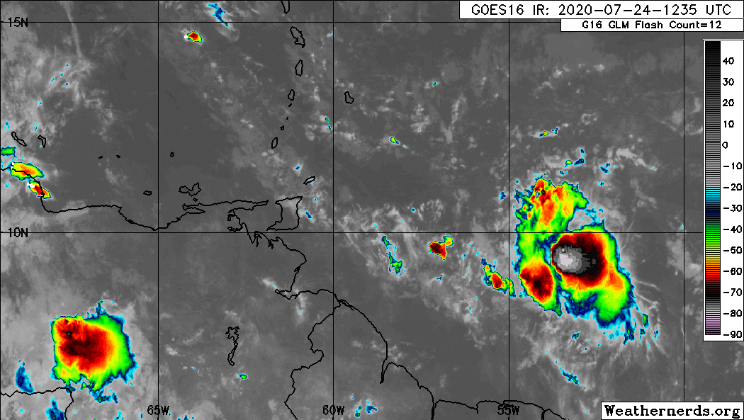
Tropical Storm Gonzalo continues to produce a compact area of moderate to strong convection in the Atlantic, east of Trinidad and Tobago.
After ingesting a hefty portion of dry, stable air (Saharan Dust) over the last 36 hours, Gonzalo has struggled to maintain its intensity, gradually weakening as it moved westward.
Convection continued to wane and restrengthen over the last several hours, with pop-up showers and thunderstorms near the system’s center.
Tropical Storm Gonzalo will be traversing warmer waters, with sea surface temperatures between 29°C and 30°C over the next 24 to 36 hours, allowing for possible strengthening. Gonzalo has broken the current record for the earliest 7th named storm formation in the Atlantic, edging out Gert on July 24th, 2005.
This tropical storm is forecast to bring adverse weather to the Southern Windwards, including T&T, on Saturday into Sunday, with tropical storm conditions generally remaining north of Trinidad but possible across Tobago. With additional southward adjustments of the track, tropical storm conditions may be possible across Trinidad.
What We Forecast
Track
Across Trinidad, south of Tobago, on Saturday, July 25th, 2020. This new track is slightly faster than last night. Models continue to trend further south, resulting in this change.

Based on present model guidance, the core (i.e., where the heaviest showers and thunderstorms may occur) is forecast to affect northeastern Trinidad and Tobago. Models, and the official forecast, have moved southward and westward on Friday.
However, based on the present steering flow, Gonzalo inches closer to T&T as it maintains a mostly westward track for now. Overall model guidance continues to trend to the south. This increases the chances of heavy rainfall and gusty winds across both islands.
Given the small radii of circulation, slight track adjustments northward would result in minimal impacts to T&T, while track adjustments southward would mean widespread heavy showers, thunderstorms, and gusty winds to the islands.

Due primarily to the adjusted initial position, the NHC track forecast has been adjusted a fair amount west and south of the previous advisory. Overall, Gonzalo is still forecast to move generally westward or west-northwestward through the period, steered by the subtropical ridge to the north. The new NHC forecast lies between the old forecast, adjusted for the new initial position, and the HFIP Corrected Consensus.
You should not focus on these relatively small shifts in the forecast track from cycle to cycle, and for the Windward Islands, in particular, consider that 24-48 hour forecast points can be off by an average of 50-80 nautical miles. That’s approximately the distance from Toco to Cedros in Trinidad.
The motion of this system continues to be westward within the stiff mid-tropospheric steering flow provided by an anchored subtropical ridge to the cyclone’s north. The song remains the same, with Gonzalo expected to speed up toward the west and west-northwest through the entire period.
Intensity
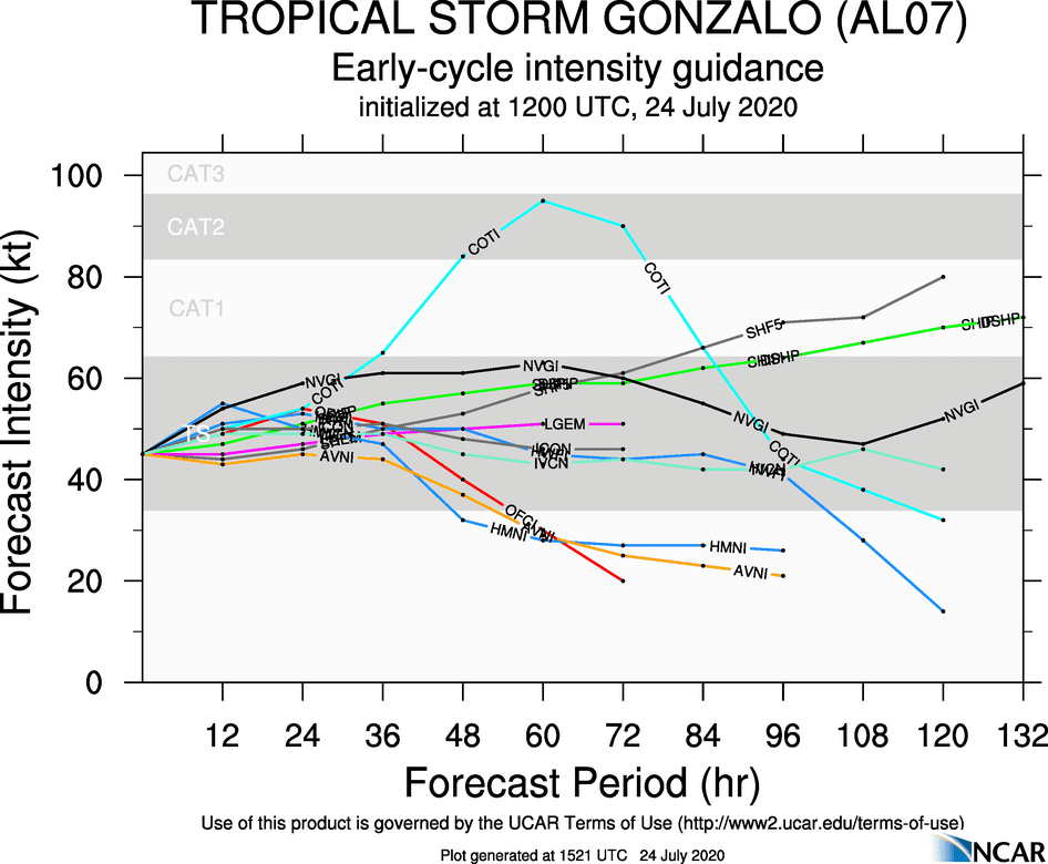
Four days later since Tropical Depression Seven formed, now Tropical Storm Gonzalo, and models still continue to grapple with the intensity of this system.
There is still greater-than-normal uncertainty in Gonzalo’s forecast intensity due to its small size and how it will behave in an environment of relatively light shear and warm sea surface temperatures counterbalanced by a lot of dry air.
Gonzalo continues to produce bursts of deep convection, especially in the southeast quadrant but has not become any better organized overall since the last advisory. Microwave imagery overnight indicated the low-level structure of Gonzalo is still largely intact, but this has not translated into better convective organization. ASCAT data, valid shortly after 12Z, revealed that Gonzalo had accelerated west faster than anticipated and had not strengthened.
Gonzalo’s small size makes it susceptible to short-term changes in intensity that cannot be reflected in the official forecast.
The intensity guidance is generally lower than it has been for the last day or so, and none of the operational models forecast Gonzalo to reach hurricane strength. Unfortunately, small storms like Gonzalo are often subject to large swings in intensity, up or down, and that aspect of the forecast remains highly uncertain, even though the spread in the guidance is not particularly high.
The NHC forecast has been adjusted only slightly lower for this cycle and is now above all of the guidance at the time the system is forecast to pass through the Windward Islands. A larger adjustment could be made later today as the recon mission found that Gonzalo is even weaker than the current estimates.
While the NHC forecast suggests a tropical storm, with sustained winds of up to 100 KM/H and gusts to 120 KM/H, may track near or across T&T, given the increased shear, proximity to dry air, and continued disorganization, it is entirely within the realm of possibility that Gonzalo weakens into a tropical depression, as a weaker system would maintain a westward path.
In this scenario, Tobago may experience tropical storm conditions, while across Trinidad, periphery impacts are more likely, but tropical storm conditions are possible. Across Trinidad, wind gusts in excess of 65 KM/H are likely in heavier showers or thunderstorms. Across Tobago, wind gusts in excess of 85 KM/H are expected.
Impacts From Tropical Storm Gonzalo
For Trinidad, the main hazard is heavy rainfall causing flooding and landslides, with gusty winds also a localized concern. For Tobago, heavy rainfall, triggering flooding, landslides as well and damaging wind gusts are the main hazards, as well as rough seas.
Much of the worst weather associated with this system will remain offshore and north and east of Trinidad and Tobago as of Friday afternoon.
Wind
Across Trinidad, wind gusts in excess of 65 KM/H are likely in heavier showers or thunderstorms. Across Tobago, wind gusts in excess of 85 KM/H are expected, with tropical storm conditions possible.
With wind gusts in excess of 85 KM/H, it will be hazardous to be outdoors. Whole trees are expected to be in motion, with tree damage likely. Outdoor objects may topple or become airborne such as garbage cans, potted plants, loose galvanize or construction material, and other outdoor furniture. Tents may jump. Older/weaker trees may fall, bringing down utility poles and lines. Power outages are expected, with damage to trees, power lines, and small structures possible.

Rainfall
Overall rainfall accumulations have increased over the three-day period between Friday through Sunday across T&T, with isolated totals high. Heavy rainfall will be possible across T&T. Generally, between 50-100 millimeters of rainfall are forecast Friday through Sunday, with isolated totals in excess of 150 millimeters in areas of persisting heavy rainfall and thunderstorm activity, mainly across Northern, Eastern Trinidad and Tobago.
Street flooding and flash flooding in heavy to violent showers and thunderstorms are likely. There is a medium chance of riverine flooding. There is a medium to high risk of landslides across Trinidad and a very high risk across Tobago.
Thunderstorms and Lightning
In thunderstorms, locally severe wind (in excess of 55 KM/H), violent rainfall rates (in excess of 50 millimeters per hour), and lightning are all possible.
Gusty winds and lightning pose a threat to our power grid, causing localized power outages. Lightning may also strike trees, homes, or utility poles, causing damage to property. Lightning can also be deadly to persons outside during a thunderstorm.
Seas and Surf
Seas, mainly on Saturday, are forecast to be moderate to rough, with waves up to 3.0 meters, occasionally up to 4.0 meters in open waters. In sheltered areas, up to 1.5 meters and choppy. A Hazardous Seas Alert is in effect.
But this model shows…
Individual model runs are just one possible outcome from a myriad of outcomes. Weather does not always follow what is modeled and even what may be forecast. Beware of individual model runs being posted on social media.
Always check the National Hurricane Center for the latest information on tropical cyclones and your local meteorological offices for country-specific advisories.
What should I do?
A tropical storm warning is in effect for Tobago, and an Adverse Weather Alert is in effect for Trinidad.
If you live in Tobago and are risk-averse, now is the time to check your inclement weather, flood, or hurricane season plan, ensuring your preparedness supplies are not expired, stocked, and in a safe location.
Across Tobago, strong wind gusts are the main hazard on that island, as well as flooding rainfall. Across Trinidad, as with most tropical systems moving through our area, our main hazard tends to be heavy flooding rainfall.
If you live in a flood-prone area, it is always recommended to prepare sandbags and ensure watercourses and guttering on your property are cleared. Secure loose objects outdoors and trim larger trees. You can request assistance from your local city, borough, or regional corporation.
If your roof is not secured, consider securing your roof with hurricane straps. A hurricane strap costs between $8 to $10. It takes about 50 straps to secure the roof of an average three-bedroom house. Most straps are available in your neighborhood hardware and are made with galvanized steel.
The Office of Disaster Preparedness and Management has put together a comprehensive guide for preparing for the Wet and Hurricane Season.


