


For the last week, Trinidad and Tobago and Guyana have been experiencing a very smoky atmosphere. While near-record dry conditions across Trinidad and Tobago have led to abundant bush and forest fires, our local fires aren’t the only culprit.
In neighboring Venezuela, their Dry Season typically extends from December to March with heavy rains returning in April and May. The country’s fire season generally follows the same pattern, with the number of fires observed by satellites tending to rise in January, peak in March, and drop in May.
Smoke from Venezuela drifting across Trinidad and Tobago and Guyana on March 29th, 2024.
And so it went for the 2024 burning season, with one key difference. In the preceding months, unusually warm and dry weather, potentially a consequence of global warming and shifting circulation and rainfall patterns associated with the ongoing El Niño, parched the country’s landscapes and primed them to burn.
NASA’s MODIS (Moderate Resolution Imaging Spectroradiometer) sensor detected a record-breaking number of fires in Venezuela in the early part of the year, according to data posted by Queimadas, a program of Brazil’s National Institute for Space Research (INPE).
Fire counts in January 2024 and February 2024 were above 9,000—higher than any other January or February since the beginning of the MODIS record in the early 2000s. In March 2024, the sensor detected more than 11,000 fires; the only other March that the sensor detected more was in 2003. VIIRS (Visible Infrared Imaging Radiometer Suite), a similar but newer sensor that can detect smaller and lower-temperature fires, also observed unusually high numbers of fires in Venezuela during the first three months of 2024, according to data posted by Global Forest Watch.
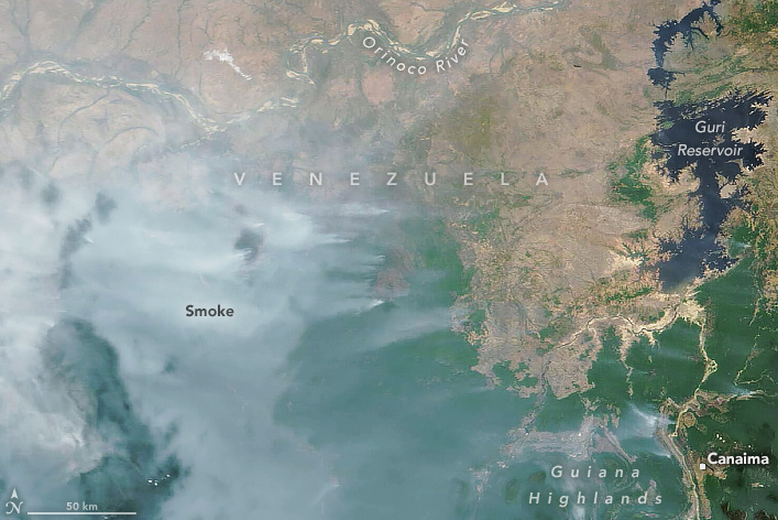
Brown areas in the northern part of the image are part of the Llanos, a mostly treeless savanna covered with seasonally flooded grasslands and cattle pastures. The green areas in the southern part of the image are rainforests that span the fringes of the Guiana Highlands, a plateau that covers the southern half of Venezuela. Data from the SERVIR Amazon Fire Dashboard indicate that several large understory forest fires have burned in the region in March.
However, for the last week, the typical easterly winds we see during March, the windiest month of the year for Trinidad and Tobago, have been nearly non-existent. As a result, smoke from Venezuela has drifted across Trinidad, Tobago, and Guyana, leading to increased smoke in the atmosphere, particularly by dusk.
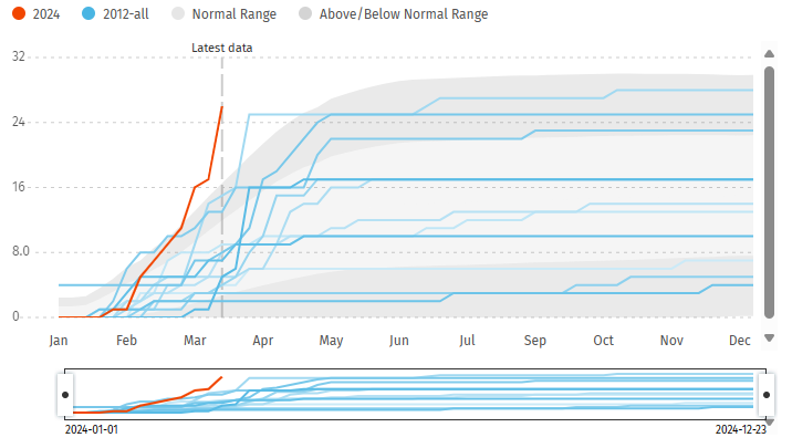
Based on data posted by Global Forest Watch, Trinidad and Tobago’s fire season, particularly larger bushfires that are detected by satellite imagery, has been off to a rapid start in 2024. Since 2012, when satellite tracking on fires began for T&T via VIIRS, 2024 has surpassed every year for the number of fires detected as of March 25th.
The dryness in Trinidad and Tobago also can’t be overstated. Since August, the country has recorded mostly below-average rainfall at its climate sites. Piarco’s monthly totals were 115.9 mm, 48.1 mm, and 3.5 mm, while Crown Point’s monthly totals were 53.4 mm, 49.0 mm, and 3.9 mm for December, January, and February. February’s rainfall totals were among the top five driest months for both Piarco, Trinidad, and Crown Point, Tobago.
For those wishing the smoke away, Trinidad and Tobago is set to see a temporary hiatus from the prevailing dry conditions. Rainfall is forecast from today (Sunday) through Wednesday as a result of a few trough systems interacting with an increase in atmospheric moisture. It is important to note that as the week progresses, dryer conditions are forecast to return as the 2024 Wet Season is likely still at least four to six weeks away, with a surge of Saharan Dust moving in by Thursday.
Editor’s note: The cover photo was captured by Sham Sahadeo in Southern Trinidad.


