


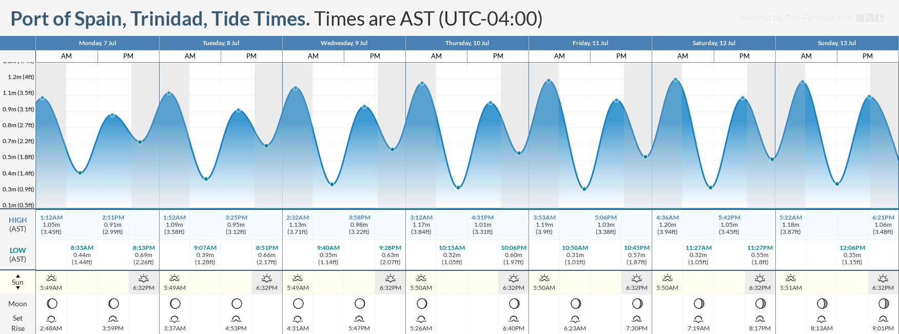
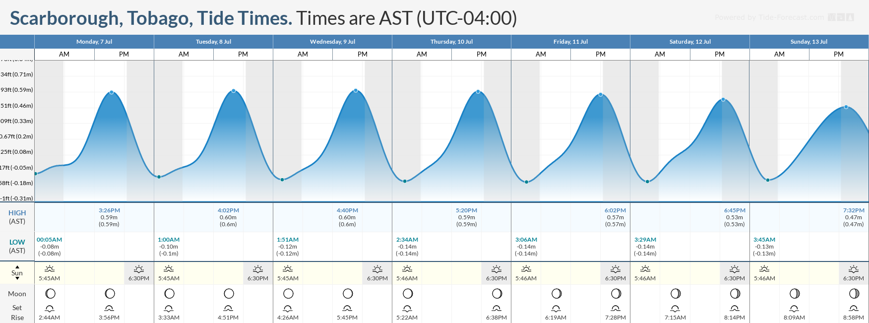
The light winds across T&T are expected to increase following the passage of a tropical wave (TW15) from Thursday evening, which will result in higher wave heights in open waters. Spring tides are ongoing, resulting in higher-than-usual high tides and lower-than-usual low tides through Sunday.
What you need to know
— What’s happening: While slight to moderate seas are forecast across the entire marine area over the next seven days, choppy seas are likely in sheltered areas during heavy showers and thunderstorms. Spring tides are set to end on July 13th. Elevated low-level winds between Thursday and Saturday will also agitate seas in open waters.
— Impacts: Choppy seas, caused by elevated winds in showers and thunderstorms, can be hazardous to smaller marine vessels, making operations difficult due to the large waves.
— What Should You Do: Inexperienced mariners should avoid navigating in hazardous conditions, especially those operating smaller vessels during heavy showers and thunderstorms. If you intend to go into the water, it is recommended that you use beaches with lifeguards on duty.
Latest Alert
There are no alerts, watches, or warnings in effect for Trinidad and Tobago from the Trinidad and Tobago Meteorological Service at this time.
Trinidad and Tobago is NOT under any tropical storm or hurricane threat, watch, or warning at this time.
Seas Forecast For Trinidad and Tobago

July 8th through 9th: Winds are forecast to range between 10 and 15 knots from the southeast to east-northeast with gusts up to 25 knots. Seas in open waters are forecast to remain moderate, with waves up to 2.0 meters. In sheltered areas, waves are forecast to range between 0.5 and 1.0 meters, with occasionally choppy conditions in isolated heavy showers or thunderstorms. Swell periods are forecast to remain between 6 and 9 seconds, with swells coming from the north. A mild concentration of Saharan Dust is forecast with little effect on visibility. Spring Tides ongoing.
July 10th through 13th: Winds are forecast to range between 15 and 20 knots from the east-southeast to northeast with gusts to 30 knots. Seas in open waters are forecast to remain moderate, with waves ranging from 1.25 to 2.0 meters. With peak winds forecast on Friday, open water wave heights may reach as high as 2.5 meters in northeastern marine areas. In sheltered areas, waves are generally forecast to be below 1.0 meters. Occasionally, choppy conditions, particularly in the Gulf of Paria, are likely in isolated heavy showers or thunderstorms. Swell periods are forecast to remain below 9seconds, with swells coming from the north. A significant surge of Saharan Dust is forecast to move across the Lesser Antilles from Thursday, with higher dust levels mainly north of Trinidad and Tobago. Still, horizontal visibility may decrease as low as five kilometers, particularly on Thursday, Saturday, and Sunday. Spring Tides are to end on the 13th.
July 14th: Winds are forecast to decrease, between 5 and 10 knots from the southeast to east-northeast and gusts to 20 knots. Seas in open waters are forecast to be slight, with waves between 1.0 and 1.25 meters, and conditions are expected to be near calm in sheltered areas. Seas may become locally choppy in the vicinity, particularly during heavy showers and thunderstorms, in the Gulf of Paria.
What should you do
All marine interests should practice common-sense safety. Small craft operators should seek safe harbor during heavy showers and thunderstorms. Inexperienced mariners, especially those operating smaller vessels, should avoid navigating in hazardous conditions. Inexperienced swimmers, if intending to go into the water, should use beaches with lifeguards on duty.
A combination of elevated winds and Saharan Dust will lead to decreased horizontal visibility between Thursday and Sunday, warranting additional caution from small craft operators.
Rip currents always pose a hazard on the nation’s beaches. If caught in a rip current, swim perpendicular to the current, parallel to the shore.
With spring tides coming into effect, mariners, especially small craft operators, should ensure their vessels are securely anchored or docked, as choppy or breaking wave conditions may drag the vessel onto the ocean floor or reefs in shallow waters, or even break the anchorage or mooring.


